July 05 , 2023.
La réunion , Piton de la Fournaise :
Press release from the Paris Institute of Earth Physics, Piton de la Fournaise Volcanological Observatory, July 04, 2023 – 1:00 p.m. – 9:00 a.m. UTC.
Ongoing eruption
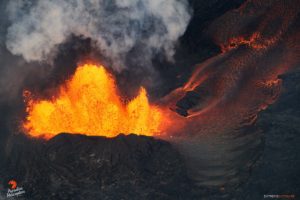
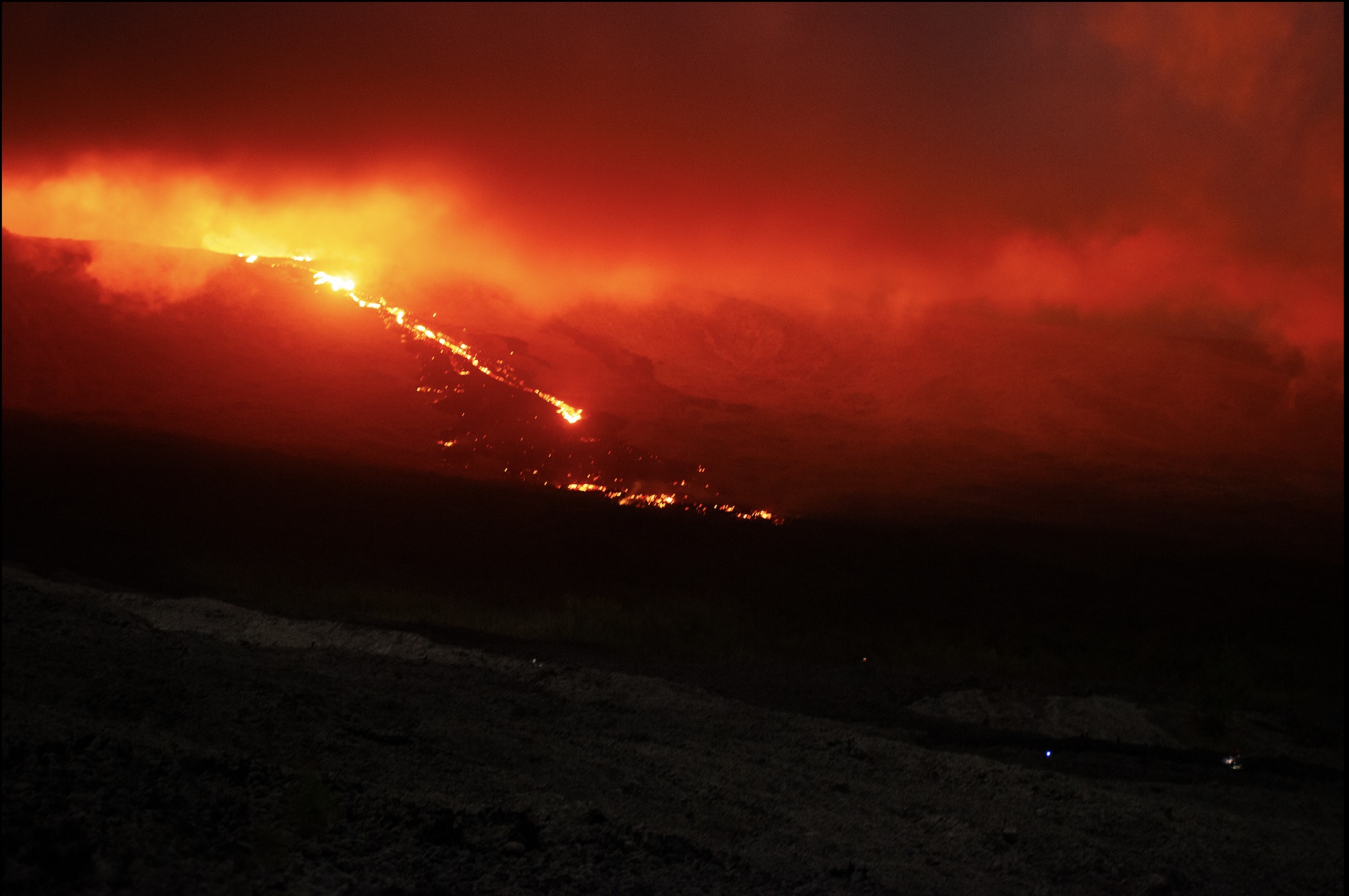
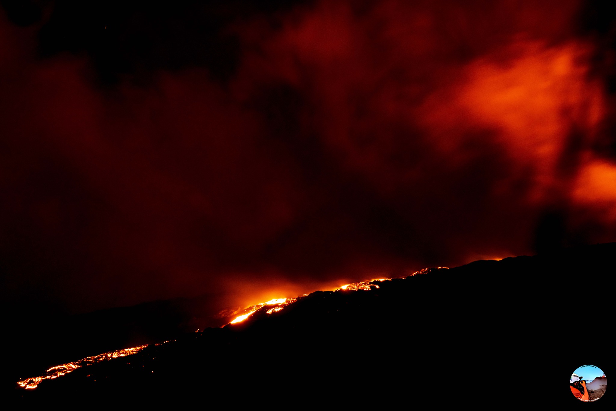
The eruption started on July 02, 2023, around 08:30 local time continues. The amplitude of the volcanic tremor (indicator of an emission of lava and gas on the surface) has remained relatively stable over the last 24 hours with some low amplitude fluctuations.
Lava flow estimates established by satellite method on the HOTVOLC (OPGC – Clermont Auvergne University) and MIROVA (University of Turin) platforms over the last 24 hours indicated flows between 5 and 20 m3 / sec.
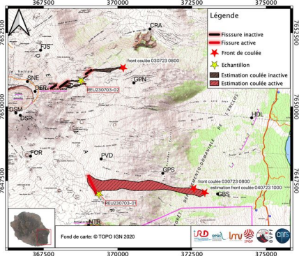
The last VIIRS satellite image acquired on July 3, 2023 at 10:24 UTC (2:24 p.m. local time) indicated that the thermal anomaly, corresponding to the extension of the flow, had propagated over a length of 3.5 km towards the East.
The images from the webcams this morning show a slow progression of the flow front. The rate of progression of the flow front over the last 24 hours is estimated at 40 m/hour. It was this morning between 2 and 2.5 km from the RN2.
Last night and tonight, the most active parts of the lava flow were located on the upper part of the Grandes Pentes.
The activity at depth is still maintained even if the number of superficial volcano-tectonic earthquakes over the last 24 hours has decreased: 162 against 1059 the previous 24 hours. Nevertheless, it is still not excluded that other eruptive cracks open, especially at lower altitudes, and/or outside the Enclos .
Increased vigilance is required in the sectors bordering the North and South Enclos . Indeed, given the high probability of the emission of degassed magma, it could be that the OVPF stations located in the sector do not record a volcanic tremor if a crack were to open at low altitude and /or outside the Enclos .
Alert level: Alert 2-1 (eruption in the Enclos without any particular threat to the safety of people, property or the environment).
Monthly Bulletin – June 2023
Seismicity
In June 2023, the OVPF-IPGP recorded at the level of the Piton de la Fournaise massif in total:
• 791 superficial volcano-tectonic earthquakes (0 to 2.5 km above sea level) under the summit craters;
• 2 deep earthquakes (below sea level);
• 18 long-period type earthquakes;
• 163 landslides.
The month of June 2023 will have been marked by an increase in seismicity under the summit from June 12, going from 4 superficial volcano-tectonic earthquakes per day at the beginning of the month to 40 per day in the second half of the month.
These earthquakes were located under the Dolomieu crater between -500 and 1200 m above sea level.
Numerous landslides in the Cratère Dolomieu, at the Broken River of the East and at the level of the flow of the eruption of September-October 2022 have also been recorded.
Deformation
Peak inflation that had stopped in early May resumed in mid-June . This slow inflation (maximum elongation of the terminal cone < 2 cm in 15 days) is linked to a pressurization of the superficial magmatic reservoir located at 1.5-2 km depth under the craters.
Source : OVPF
Photos : OVPF , Vincent Tunneldelave Réunion.
Italy / Sicily , Etna :
WEEKLY BULLETIN, from June 26, 2023 to July 02, 2023, (issue date July 04, 2023)
ACTIVITY STATUS SUMMARY
In the light of the monitoring data, it is highlighted:
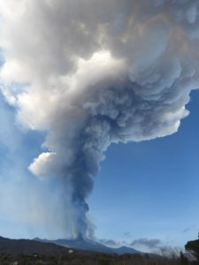
1) VOLCANOLOGICAL OBSERVATIONS: Degassing activity at the summit craters, in particular continuous degassing at the Southeast crater (CSE) and at the Bocca Nuova crater (BN).
2) SEISMOLOGY: moderate increase in fracturing seismicity; amplitude of tremor in the range of mean values; location of the sources of the tremor in the area of the Southeast crater
3) INFRASOUND: Low activity level: moderate increase compared to the previous week and sources located at the Bocca Nuova crater and subordinate to the Southeast crater.
4) GROUND DEFORMATIONS: Data from ground deformation monitoring networks did not show any significant variations.
5) GEOCHEMISTRY: SO2 flux at an average level.
The CO2 fluxes show a decreasing trend based on average degassing values.
There are no Helium isotope ratio updates.
The partial pressure of dissolved CO2 does not show any significant variations.
6) SATELLITE OBSERVATIONS: Thermal activity observed from the satellite was generally weak.
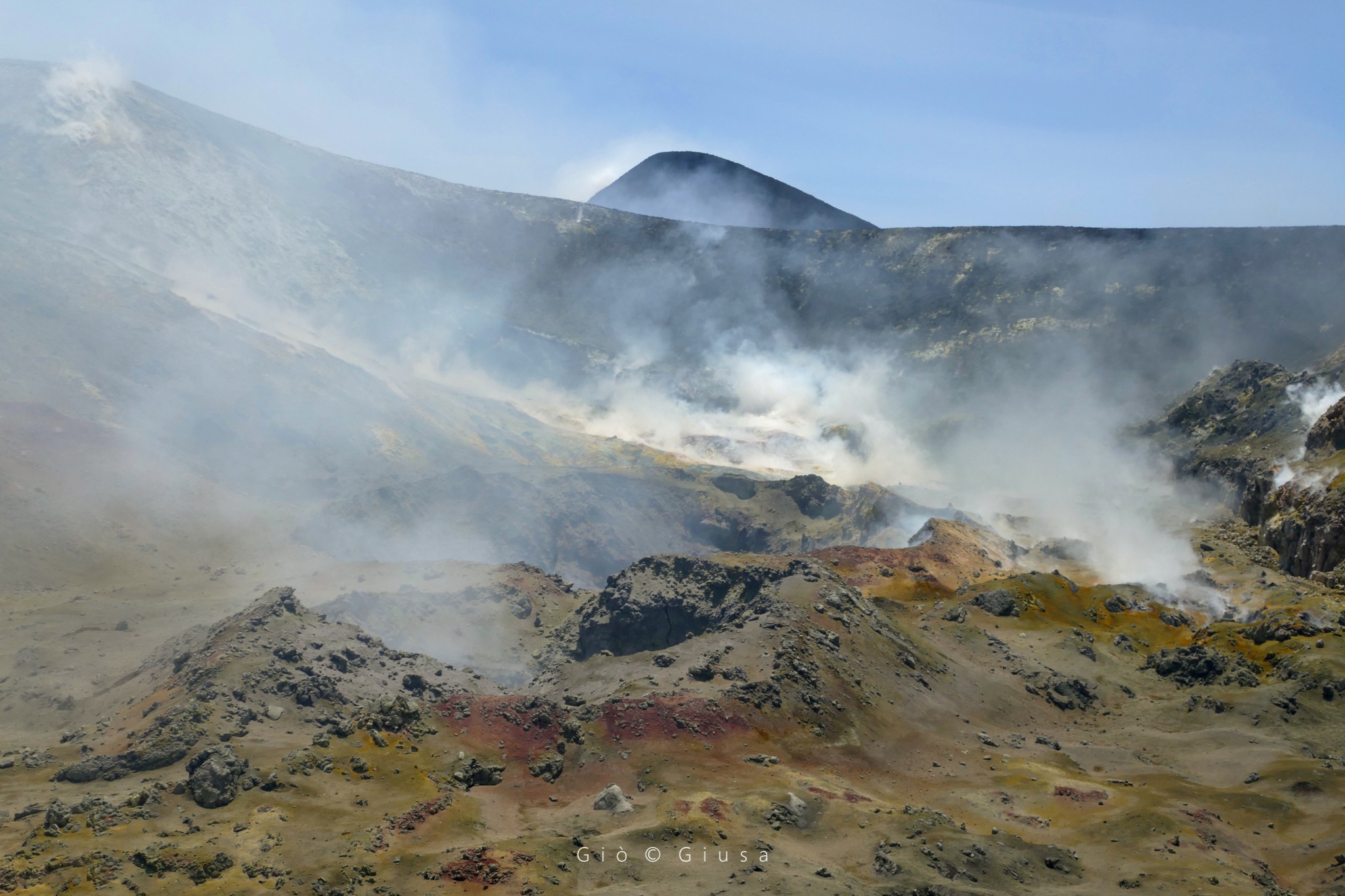
La Bocca Nuova and the summit of the Southeast Crater
VOLCANOLOGICAL OBSERVATIONS
During the week, monitoring of Etna’s activity was carried out through the network of surveillance cameras of the INGV – Osservatorio Etneo. Throughout the period, sightings were discontinued due to fog and cloud cover, which often affected the summit area during the day.
During the week, without significant variations compared to the previous weeks, the degassing of the summit craters continued, especially of the Southeast crater (SEC) and to a much lesser extent of the Bocca Nuova crater (BN). Weak vapor emissions from the Northeast Crater (NEC) were observed only under conditions of high atmospheric humidity.
SEISMOLOGY
During the week in question, an increase in the rate of occurrence of earthquakes and stress releases was observed, mainly determined by the occurrence of a seismic swarm which, from the afternoon of the 27th to the first hours of June 28, affected the sector on the east side of the volcano, in an area between the towns of Zafferana Etnea, S. Venerina and Fleri, at depths between ground level and 12 km below sea level. Only 6 events exceeded the magnitude 2 threshold. The largest energy release was associated with an earthquake on June 27 at 22:12 UTC (ML = 3.1), located 1.5 km north of Zafferana Etna at a depth of 2.3 km below sea level.
Source : INGV.
Photo : Gio Giusa.
Italy , Stromboli :
WEEKLY BULLETIN, from June 26, 2023 to July 02, 2023, (issue date July 04, 2023)
ACTIVITY STATUS SUMMARY
In the light of the monitoring data, it is highlighted:
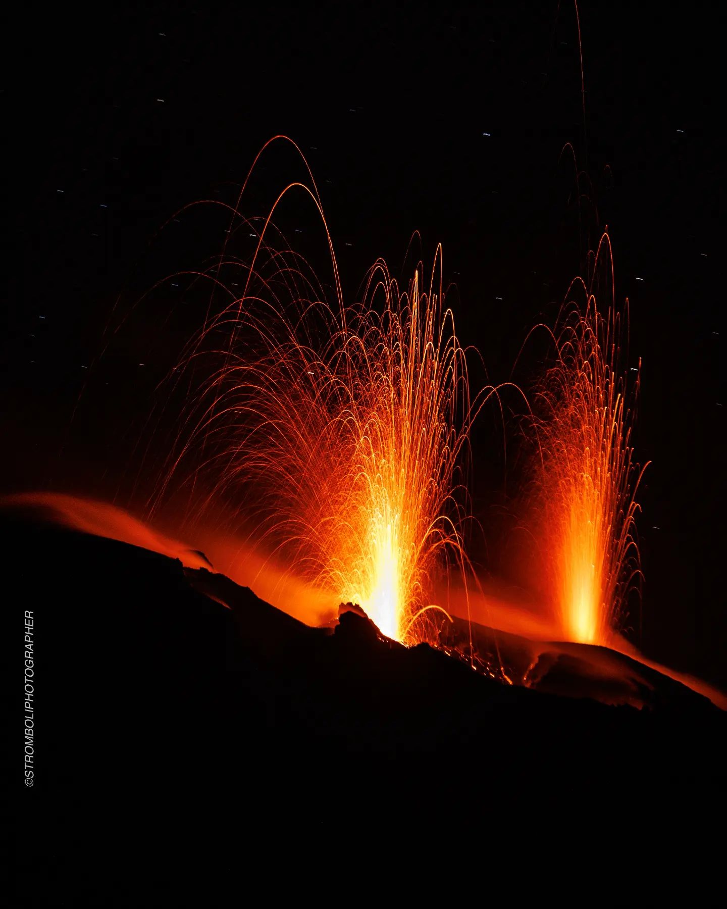
1) VOLCANOLOGICAL OBSERVATIONS: Explosive volcanic activity of Strombolian type mainly produced by the Center-South zone and with the total frequency of explosions at a medium and stable level. The intensity was mainly low in the North crater zone and medium in the Center-South crater zone.
2) SEISMOLOGY: The seismological parameters monitored do not show any significant variations.
3) GROUND DEFORMATIONS: The ground deformation monitoring networks did not show any significant variations.
4) GEOCHEMISTRY: The flow of SO2 is placed on a medium and medium-low level
The CO2 flux in the Pizzo area displays medium to high values.
There are no C/S data updates in the plume.
There is no update on the isotope ratio of helium in groundwater.
5) SATELLITE OBSERVATIONS: The thermal activity observed from the satellite was generally weak.
VOLCANOLOGICAL OBSERVATIONS
In the period under observation, the eruptive activity of Stromboli was characterized by the analysis of the images recorded by the surveillance cameras of the INGV-OE at an altitude of 190 m (SCT-SCV), from the Pizzo sopra la Fossa (SPT) and Punta dei Corvi (SPCT). The explosive activity was mainly produced by the Center-South zone and secondarily by the eruptive vents located in the North zone of the crater.
During the week, modest landslides occurred in the area corresponding to the base of the North Zone of the crater, caused by the detachment of material from the ravine niche produced following the active eruption of October 2022 .
Observations of explosive activity captured by surveillance cameras
In the northern zone of the crater (N), characterized by a vent located in the N1 sector and one in the N2 sector, a low intensity explosive activity was observed (the eruptive products reached a height of less than 80 m) in the two sectors. The component of eruptive products was a mixture of coarse materials (bombs and lapilli) and fine materials (ash). The average frequency of explosions varies between 3 and 5 events/h.
With regard to the Center-South (CS) zone, sector S1 showed high pressure degassing sometimes associated with the emission of coarse materials, while sector C showed no explosive activity. Sector S2, with three active vents, mainly showed explosive activity of variable intensity from low to medium with emission of coarse material mixed with fine material. The average frequency of explosions fluctuates between 7 and 9 events/h.
Source : INGV.
Photo : Stromboli Stati d’animo
Philippines , Mayon :
MAYON VOLCANO BULLETIN 05 July 2023 8:00 AM
In the past 24-hour period, a very slow effusion of lava from the summit crater of Mayon Volcano continued to feed lava flows and collapse debris on the Mi-isi (south) and Bonga (southeastern) gullies as well as rockfall and PDCs on these and the Basud (eastern) Gullies. The lava flows have advanced to approximate lengths of two thousand eight hundred (2800) meters and one thousand three hundred (1300) meters along Mi-isi and Bonga gullies, respectively, from the summit crater while collapse debris has deposited to four thousand (4000) meters from the crater. Five (5) dome-collapse pyroclastic density currents (PDC) that lasted from two (2) to two and a half (2.5) minutes, two hundred thirty-two (232) rockfall events, one (1) volcanic earthquake, and an ongoing repetitive pulse tremor observed since 3:47 PM (PST) of July 3, 2023, were recorded by the Mayon Volcano Network.
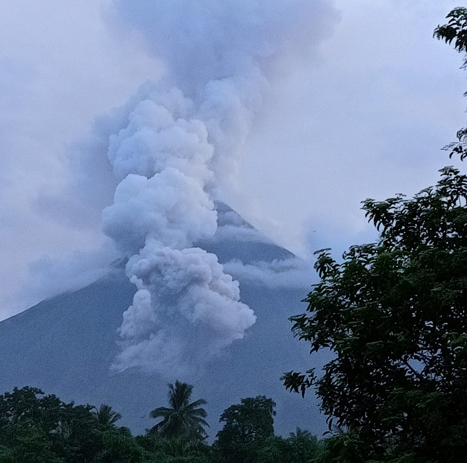
Continuous moderate degassing from the summit crater produced steam-laden plumes that rose 200 meters before drifting to the west-northwest and west-southwest direction. Sulfur dioxide (SO2) emission averaged 1,170 tonnes/day on 04 July 2023. Short-term observations from EDM and electronic tiltmeter monitoring show the upper slopes to be inflating since February 2023. Longer-term ground deformation parameters based on EDM, precise leveling, continuous GPS, and electronic tilt monitoring indicate that Mayon is still inflated, especially on the northwest and southeast.
Alert Level 3 is maintained over Mayon Volcano, which means that it is currently in a relatively high level of unrest as magma is at the crater and hazardous eruption within weeks or even days is possible.
Source : Phivolcs.
Photo : Christina Fegason
Colombia , Chiles / Cerro Negro :
Weekly activity bulletin of the volcanic complex of Chiles and Cerro Negro (CVCCN)
Regarding the monitoring of the activity of the VOLCANOES CHILES AND CERRO NEGRO, the MINISTRY OF MINES AND ENERGY through the COLOMBIAN GEOLOGICAL SERVICE (SGC) informs that:
For the week between June 27 and July 3, 2023, and compared to the immediately preceding week, a decrease in seismic activity was recorded, both in occurrence and in energy released. The predominance of earthquakes associated with rock fracturing within the volcanic edifice continued, followed by seismicity related to fluid movement.
Seismicity related to rock fracturing was located mainly south of the Chiles volcano at distances up to 4 km, had depths less than 6 km from its summit (4700 m altitude) and a maximum magnitude of 2, 2. No felt earthquakes were reported.

The soil deformation processes continue on the volcanic edifice, detected instrumentally by the sensors installed on the volcanoes and also by remote satellite sensors.
The possibility of earthquakes of considerable energy that can be felt by residents of the area of influence remains.
The activity level of volcanoes remains at the YELLOW LEVEL ■ (III): CHANGES IN THE BEHAVIOR OF VOLCANIC ACTIVITY
Source : SGC
Photo : igepn
Iceland , Fagradalsfjall :
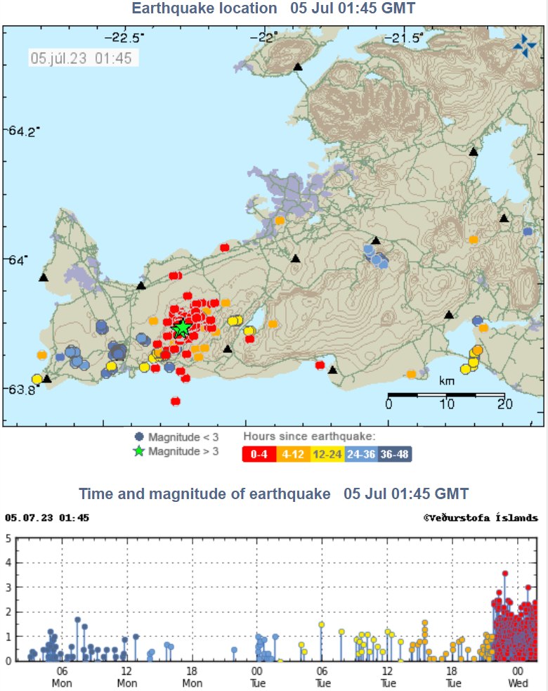
Around 16:00 yesterday (4/7) a swarm of earthquakes started in Fagradalsfjall. Roughly 1000 earthquakes have been measured and have the largest earthquakes been felt in the capital area. Continued seismic activity can be expected during the day.
Two earthquakes were located in the caldera of Bardarbunga, a M3.3 at 20:00 and a M3.9 at 20:02. Earthquakes of these magnitudes are not unusual in Bardarbunga.
Land rising on Reykjanes likely caused by magma
A land rise of around two to two and a half centimeters of land is now measured on the Reykjanes Peninsula, which is most likely caused by magma accumulation. Seismic activity has been fairly consistent lately.
Hildur María Friðriksdóttir, a natural disaster expert at the Icelandic Meteorological Office, says that there have been continuous increases since the beginning of April. Land has risen by two to two and a half centimetres according to measurements on the entire peninsula.
« What we have been seeing now is a steady rise at Fagradalsfjall, although we are not seeing anything sudden. We are seeing land rise which is presumably due to magma that is accumulating again under there. It is still at quite a depth. The situation is currently stable, » says Hildur.
The Met Office is closely monitoring developments.
It is not unlikely that the land rise is a precursor to a volcanic eruption. However, Hildur María says that little can be said about if and when the eruption will begin.
« There is currently no indication of an eruption. I dare not promise anything, but there is no indication of an eruption as of now. »
Sources : IMO Iceland , RUV.
Photo : IMO.