July 01 , 2023.
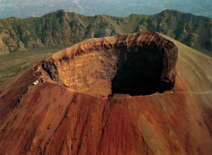
Hawaii , Kilauea :
HVO/USGS Volcanic Activity Notice
Current Volcano Alert Level: ADVISORY
Previous Volcano Alert Level: WATCH
Current Aviation Color Code: YELLOW
Previous Aviation Color Code: ORANGE
Issued: Friday, June 30, 2023, 8:35 AM HST
Source: Hawaiian Volcano Observatory
Notice Number: 2023/H245
Location: N 19 deg 25 min W 155 deg 17 min
Elevation: 4091 ft (1247 m)
Area: Hawaii
Volcanic Activity Summary:
Kīlauea is no longer erupting. Lava supply to the Halemaʻumaʻu lava lake ceased on June 19 based upon lava lake levels and behavior of the crater floor. Sulfur dioxide emissions have decreased to near pre-eruption background levels.
Accordingly, the USGS Hawaiian Volcano Observatory (HVO) is lowering the Volcano Alert Level for ground-based hazards from WATCH to ADVISORY and the Aviation Color Code from ORANGE to YELLOW.

Seismic activity—including eruptive tremor—in the summit region has been low since the eruption ceased. Over that period, gradual inflation has been recorded at summit tiltmeters. Overnight webcam views showed some incandescence from previously erupted lava as the lava proceeds to cool. There remains the potential for eruptive activity to resume in the near future at or near the summit of Kīlauea with little or no warning.
HVO continues to closely monitor Kīlauea for signs of renewed activity. Should volcanic activity change significantly, a new Volcanic Activity Notice will be issued.
Remarks:
Hazard Analysis:
Levels of volcanic gas (sulfur dioxide and carbon dioxide) can remain locally hazardous even though Kīlauea is no longer erupting. Sulfur dioxide (SO2) gas emissions have greatly decreased; however, local concentrations of sulfur dioxide (SO2) or hydrogen sulfide (H2S) may persist in downwind areas, and residents may notice odors of these gases occasionally. Significant hazards also remain around Halemaʻumaʻu from crater wall instability, ground cracking, and rockfalls that can be enhanced by earthquakes within the area closed to the public.
Source : HVO
Photo : USGS/ M. Zoeller.
Alaska , Great Sitkin :
52°4’35 » N 176°6’39 » W,
Summit Elevation 5709 ft (1740 m)
Current Volcano Alert Level: WATCH
Current Aviation Color Code: ORANGE
Lava continued to erupt slowly at Great Sitkin over the past week, adding to a thick lava flow confined to the summit crater. Multiple satellite radar images this week showed that the lava continues to slowly move to the east into the intracrater glacier. Weakly elevated surface temperatures and a steam plume were observed in satellite data this week in mostly cloudy viewing conditions. More than twenty earthquakes were located beneath Great Sitkin over the past week, but the earthquakes were all small with magnitudes lower than 1.
Great Sitkin is monitored by local seismic and infrasound sensors, satellite data, web cameras, and regional infrasound and lightning networks.
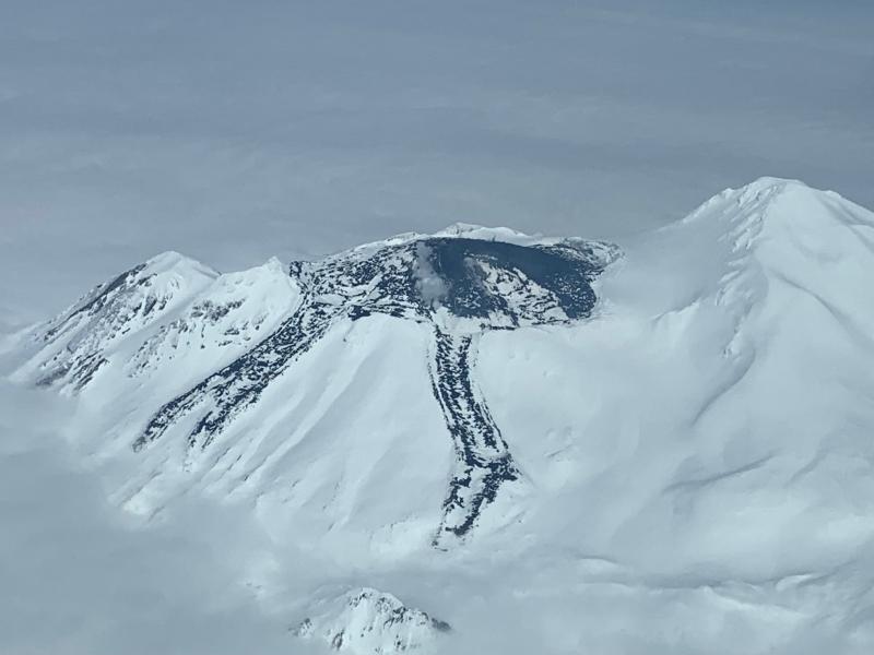
Great Sitkin Volcano is a basaltic andesite volcano that occupies most of the northern half of Great Sitkin Island, a member of the Andreanof Islands group in the central Aleutian Islands. It is located 26 miles (43 km) east of the community of Adak. The volcano is a composite structure consisting of an older dissected volcano and a younger parasitic cone with a ~1 mile (1.5 km)-diameter summit crater. A steep-sided lava dome, emplaced during the 1974 eruption, occupies the center of the crater. That eruption produced at least one ash cloud that likely exceeded an altitude of 25,000 ft (7.6 km) above sea level. A poorly documented eruption occurred in 1945, also producing a lava dome that was partially destroyed in the 1974 eruption. Within the past 280 years a large explosive eruption produced pyroclastic flows that partially filled the Glacier Creek valley on the southwest flank.
Source : AVO
Photo : Clum, Dave.
Philippines , Mayon :
MAYON VOLCANO BULLETIN 01 July 2023 8:00 AM
Eruptive activity at Mayon Volcano yesterday was dominated by the generation of dome-collapse pyroclastic density currents or PDCs on the Basud Gully on the eastern slopes. The largest of these events occurred at 1:01 PM and lasted eight (8) minutes based on the seismic record. Four (4) visible PDCs between 6:00 PM and 8:00 PM that lasted approximately four (4) minutes each traveled 3 to 4 kilometers downslope of the Basud Gully and generated one (1) kilometer-tall ash clouds that drifted to the north and northwest. Ashfall was recorded to have fallen on Tabaco City. For the past 24-hour observation period, very slow effusion of lava from the summit crater of Mayon Volcano continued to feed lava flows on the Mi-isi (south) and Bonga (southeastern) gullies as well as rockfall and PDCs on these and the Basud (eastern) Gullies. Lava flows advanced to approximate lengths of two thousand two hundred thirty (2230) meters and one thousand three hundred (1300) meters along Mi-isi and Bonga gullies, respectively, from the summit crater while collapse debris deposited to three thousand three hundred (3300) meters from the crater
.
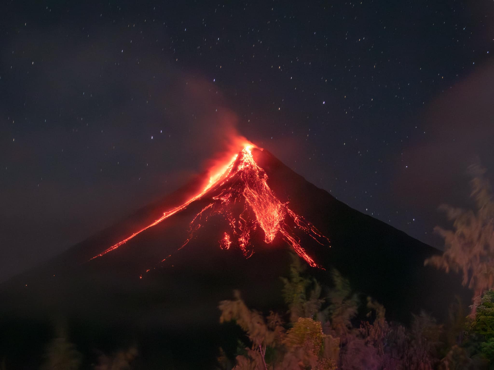
A total of seventeen (17) dome-collapse pyroclastic density currents (PDC), two hundred fifty-four (254) rockfall events, and sixty-five (65) weak volcanic earthquakes were recorded by the Mayon Volcano Network. Continuous voluminous degassing from the summit crater produced steam-laden plumes that rose 2000 meters before drifting to the east-northeast and general west direction. Sulfur dioxide (SO2) emission averaged 1,002 tonnes/day yesterday and was first detected in significant concentrations by satellite monitors on 29 June 2023. Short-term ground deformation parameters from EDM and electronic tiltmeter monitoring indicate inflation of the upper slopes since February 2023, while longer-term data including those from Precise Leveling and continuous GPS, and electronic tilt monitoring indicate that Mayon is still inflated particularly its northwest and southeast slopes.
Alert Level 3 is maintained over Mayon Volcano, which means that it is currently in a relatively high level of unrest as magma is at the crater and hazardous eruption within weeks or even days is possible.
Source : Phivolcs
Photo : Rick Estillomo
Peru , Ubinas :
Analysis period: June 29-30, 2023 Arequipa, June 30, 2023.
Alert Level: YELLOW
The Geophysical Institute of Peru (IGP) reports that the geophysical processes that allow to know the dynamic behavior of the Ubinas volcano (Moquegua region) continues to record an increase in its seismic activity associated with the rise of magma, thermal anomalies in its crater and the recording of slight ash emissions. For this, it is suggested that the authorities raise the volcanic alert level to the Orange level.
During the analysis period, the occurrence of 173 volcano-tectonic (VT) type earthquakes was detected, associated with rock breaking processes that occur inside the volcano. In addition, 351 seismic signals of the long period type (LP) were recorded, associated with the movements of volcanic fluids (gas and magma), with a maximum energy of 0.3 Megajoules. Finally, the first seismic signals of the harmonic tremor type were observed, in direct relation to the rise of the magma. In this axis, the seismic signals associated with ash emissions have increased in recent hours. For all this, the magmatic phase (volcanic explosions) could occur in a short or medium duration.
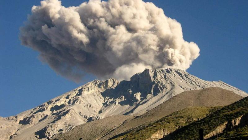
The monitoring of the deformation of the volcanic structure, show variations of less than 5 mm of displacement (within the margin of error of the instruments). Satellite monitoring shows since June 26 a thermal anomaly in the crater of Ubinas with a maximum value of 8 MW. The surveillance cameras made it possible to identify columns of gas and ash which reached heights of up to 800 m above the summit of the volcano, which were dispersed mainly towards the West, South-West, North-West sectors. West, East and North-East of the Ubinas volcano. Finally, the values of the flow of sulfur dioxide (SO2) reached between 600 and 1150 t/d
RECOMMENDATIONS
• Raise the Volcanic Alert Level to ORANGE.
Source : IGP.
Photo : Auteur inconnu.
Ecuador , Cotopaxi :
DAILY REPORT OF THE STATE OF COTOPAXI VOLCANO, Friday June 30, 2023.
Information Geophysical Institute – EPN.
Surface activity level: Moderate, Surface trend: Downward.
Internal activity level: Moderate, Internal trend: Downward.
Seismicity: From June 29, 2023, 11:00 a.m. to June 30, 2023, 11:00 a.m.:
The number of seismic events recorded at the reference station over the past 24 hours is shown below.
Emission Tremor (TREMI) 6
Long Period (LP): 18
Lahars (LH): 2.

Rains / Lahars:
In the afternoon of June 29, two seismic signals were recorded related to the descent of small flows of muddy water on the western flank of the volcano. The flows were formed by light thaws due to intense sunny weather.
Emission / Ash Column:
During the afternoon of yesterday and the morning of today, several small emissions of gas and water vapor were observed at heights less than 200 meters above the level of the crater.
Gas:
The Mounts satellite system reports 319.5 tonnes of SO2 recorded on 2023-06-29 at 1:38 p.m. TL.
Observation:
Most of the time the volcano remained partially clear.
Alert level: Yellow.
Source : IGEPN
Photo : Cris Carrillo