December 5 , 2022.
Indonesia, Semeru :
Press release on the volcanic activity of Mount Semeru, December 3, 2022.
The present character of the eruptions of the Semeru volcano is in the form of explosive eruptions that alternate with effusive eruptions. Volcanic-like ash eruptions occur daily, which are sometimes accompanied by lava avalanches and hot cloud avalanches. Hot avalanche flows led to the opening of the Southeast Crater, which leads upstream from Besuk Kobokan, Besuk Bang and Besuk Kembar. The current activity level for Mount Semeru is Level III (SIAGA) as of December 16, 2021.
The latest developments in the activity of the Semeru volcano from November 1, 2022 to December 2, 2022 at 24:00 WIB are as follows:
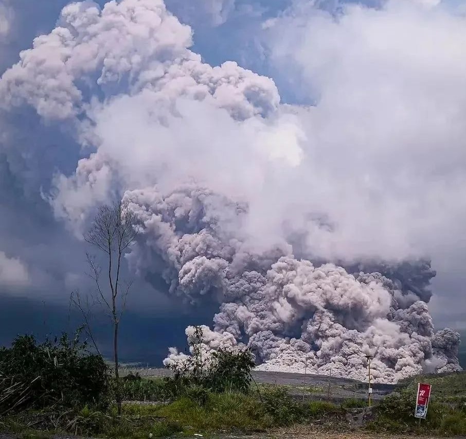
Visual monitoring of Mount Semeru shows ash eruptions occurring with an average of 88 eruptions per day. Hot cloud avalanches occurred 2 times with a maximum slip distance of 4.5 km from the summit. The smoke from the main crater is observed to be white / gray with low to thick intensity and reaches a height of 50 to 1500 meters above the summit.
Seismic activity recorded 2919 eruption earthquakes, 2 hot cloud earthquakes, 81 avalanche earthquakes and 137 emission earthquakes. This shows that hot avalanche cloud activity still has the potential to occur due to deposition of material from the eruption center. Besides the potential for hot cloud formation, the potential for lahar descents is still high given the relatively high rainfall on Mount Semeru.
Deformation monitoring still shows inflation (increasing pressure), indicating that the magma feeding process is continuing in the magma chamber or on the surface. Monitoring of hotspots shows a thermal anomaly of about 12 Mw around the crater area which indicates that there is still a lot of hot material in the crater of Mount Semeru.
Considering that the activity of the Semeru volcano is still high and that there is still a potential for hot cloud avalanches and lava flows, the Geological Agency said that the activity level of the Semeru volcano is still at level III (SIAGA) until December 2. 2022.
Considering that the level of activity of the Semeru volcano is currently still at level III (SIAGA), the public/visitors/tourists are advised not to carry out any activity in the Southeast sector along Besuk Kobokan, until 13 km from the summit (the center of the eruption). Outside of this distance, the community should not carry out activities within 500 meters of the bank (river edge) along Besuk Kobokan as it has the potential to be affected by cloud expansion. hot and lahar descents up to a distance of 17 km from the summit.
Press release RECLASSIFICATION OF THE STATUS OF G. SEMERU FROM LEVEL III (SIAGA) TO LEVEL IV (AWAS)
Hot clouds were observed at a distance of 12 km from the summit and are still in progress.
• Smoke from the main crater was not observed.
• The distribution of eruptive material in the form of incandescent rock eruptions is estimated at a radius of 8 km from the summit, while ash-sized ejected material currently reaches 12 km to the southeast. The distribution direction and distance of this ash material may change depending on wind direction and speed.
• The direction of the avalanches and the sliding of the hot avalanche clouds is towards the South-East and South sectors of the summit, The sliding distance of the hot avalanche clouds has reached more than 13 Km. Lahars can occur along rivers flowing through the area.
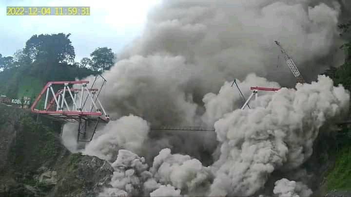
The results of the visual and seismic monitoring analysis showed an increase in activity, and it was assessed that the activity level of G. Semeru was raised from level III (SIAGA) to level IV (AWAS) , from December 4, 2022 at 12:00 WIB
At least 1,979 people have been moved to shelters following the eruption of the Semeru volcano on Sunday. The alert level was raised to level 4 with the ban on approaching within 8 kilometers of the volcano after a rain of ash and potential new explosions.
According to local media, no fatalities have been reported so far, while rescue teams continue to evacuate and search for potential victims in Lumajang, the worst affected area after the eruption.
Source : PVMBG.
Photos : Berita Viral 24Jam , Red climatica Mundial.
Italy , Stromboli :
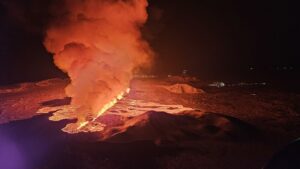
Statement on Stromboli activity, 04 December 2022, 16:38 (15:38 UTC).
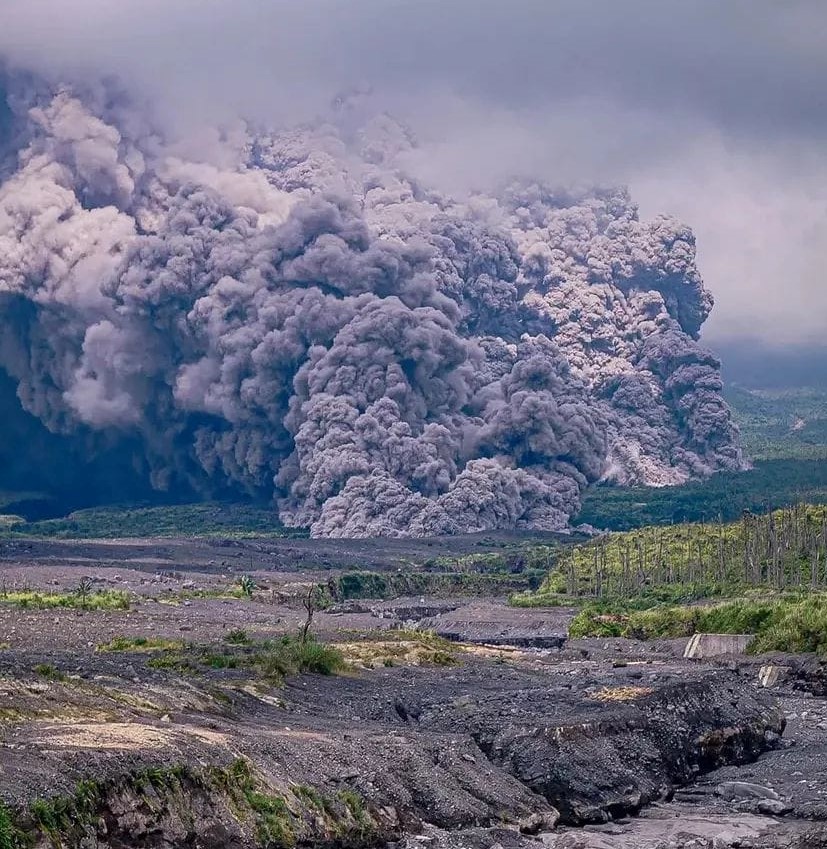
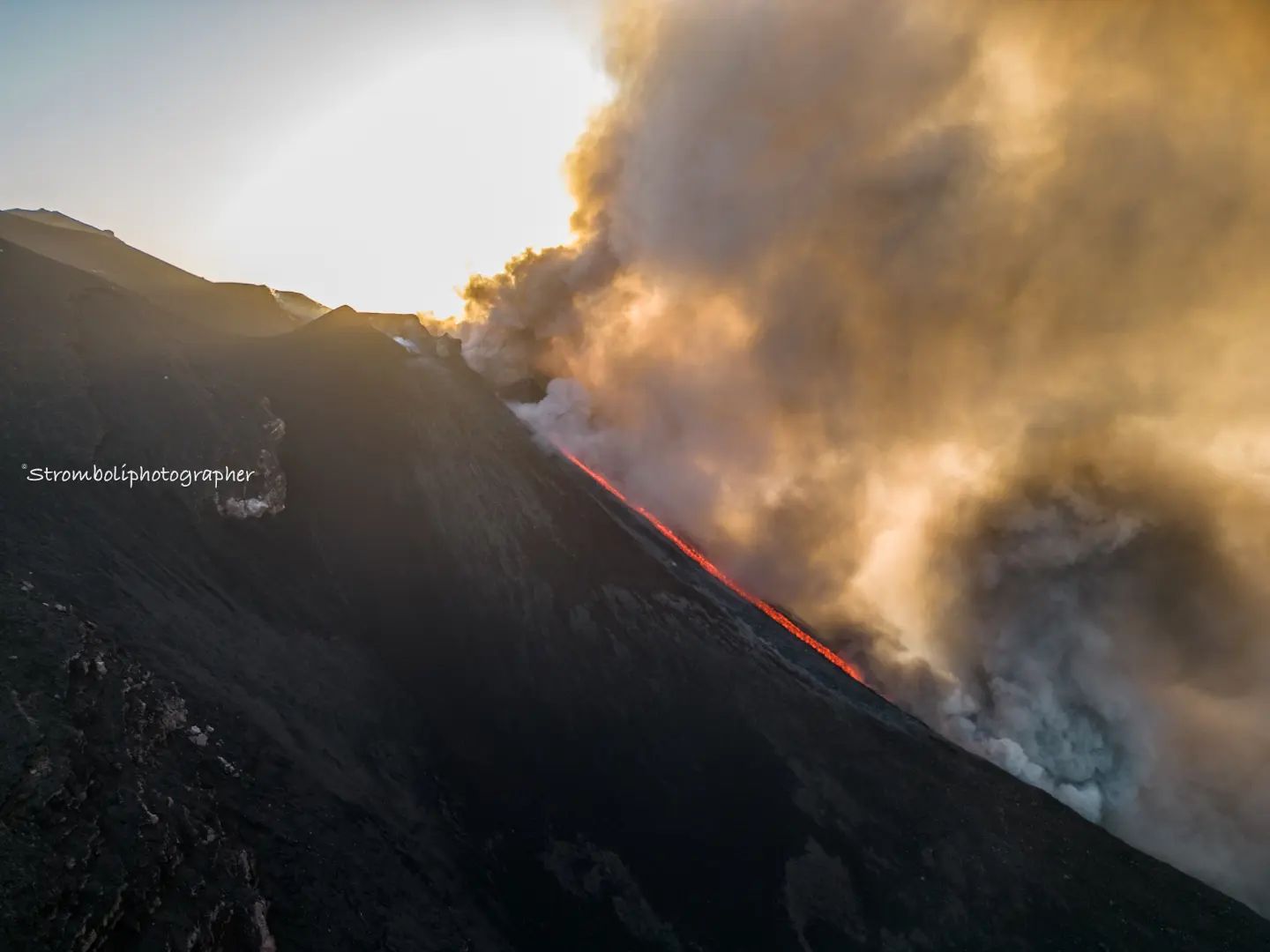
The National Institute of Geophysics and Volcanology, Osservatorio Etneo, reports that monitoring networks recorded at 4:35 p.m. (3:35 p.m. UTC), that from 2:10 p.m. UTC, there was an overflow of lava from the area of the North crater concomitantly with which intense explosive activity continued at the vent of the northern zone of the crater. At 14:16 UTC, there was a more intense explosion from the South-Central crater area. From 14:28 UTC, small collapses of material began to be observed along the upper part of the Sciara del Fuoco and at 14:31 UTC, while lava overflow and explosive activity continued, one or more flows pyroclastics probably triggered by the collapse of part of the northern sector crater rim.
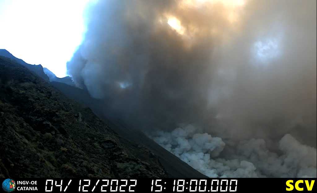
At 15:19 UTC the formation of another large pyroclastic flow is observed. From a seismic point of view, the average amplitude of the volcanic tremor is currently in the medium-high level with a tendency to increase. Current signals from available ground deformation monitoring networks show no significant variations. The GNSS and inclinometer stations of Timpone del fuoco (STDF) showed modest signal disturbances, associated with the seismic activity recorded this morning in the wind zone.
Further updates will be communicated promptly and in any case within 3 hours of this press release.
At 3:28 p.m. local time and 4:18 p.m. local time, two landslides occurred in the Scaria del Fuoco, the second of which generated a tsunami of approximately 1.5 m at the two monitoring buoys, which triggered the alert tsunami and the sound of sirens.
Statement on Stromboli activity, 04 December 2022, 19:06 (18:06 UTC)
The National Institute of Geophysics and Volcanology, Osservatorio Etneo, communicates that the large pyroclastic flow of 15:19 UTC, described in the press release of 15:35 UTC, continued for several minutes producing abundant ash which temporarily prevented the view of the summit area. At 15:40 UTC, it was possible to observe a lava flow which was channeled along the Sciara del Fuoco and which around 16:00 UTC arrived on the coast. As the ash cloud cleared, explosive activity was observed to continue at the vent in the northern crater area. Fine materials are dispersed by light southwesterly winds.
From a seismic point of view, from 14:00 UTC, an increase in the amplitude of the volcanic tremor was observed which reached very high levels around 15:00 UTC in conjunction with the pyroclastic flow at 14:31 UTC. At 15:19 UTC, a seismic signal was observed, of considerable amplitude, attributable to a second pyroclastic flow. Currently, the amplitude of the volcanic tremor is at average levels.
Signals from soil deformation monitoring networks show no significant changes. The Timpone del fuoco (STDF) inclinometer station showed an impulsive variation in correspondence with the pyroclastic flow of 15:19 UTC.
Further updates will be communicated soon.
Source : INGV.LGS.
Photo : INGV. Stromboli Stati d’animo .
Hawaii , Mauna Loa :
HVO/USGS Volcanic Activity Notice
Current Volcano Alert Level: WARNING
Current Aviation Color Code: ORANGE
Previous Aviation Color Code: RED
Issued: Sunday, December 4, 2022, 8:10 AM HST
Source: Hawaiian Volcano Observatory
Notice Number: 2022/H628
Location: N 19 deg 28 min W 155 deg 36 min
Elevation: 13681 ft (4170 m)
Area: Hawaii
Volcanic Activity Summary:
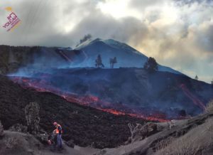
Lava eruption from fissure 3 on the Northeast Rift Zone of Mauna Loa continues, but the threat to aviation of significant volcanic ash emission into the atmosphere has passed. For this reason, HVO is reducing the aviation color code from RED to ORANGE.
The ground-based volcano alert level will remain at WARNING, reflecting the ongoing hazards of the fissure 3 lava flow. Lava flows are slowly moving north toward Daniel K. Inouye Highway and are spreading out and inflating (thickening) as they advance over low-sloping ground. The fronts of lava flows can break open unexpectedly, sending flows in several directions. Rain on lava creates steam and reduces visibility. If visiting the County of Hawai’i public viewing area, remain with your vehicle and do not approach the flows.
The Federal Aviation Administration has issued a temporary flight restriction extending from the surface to 1500 feet (457 meters) above ground level in the eruption area.

Aerial view of fissure 3 erupting on the Northeast Rift Zone of Mauna Loa the morning of December 4, 2022. Lava fountaining at the vent has been approximately 100 feet (33 m) tall over the past day, depositing fragments of volcanic material in the area near the vent.
Remarks:
The eruption has now focused at a single vent, fissure 3, at an elevation of 11,500 ft (3510 m) along the Northeast Rift Zone of Mauna Loa. Lava fountaining at the vent has been approximately 100 feet (33 m) tall over the past day, depositing fragments of volcanic material in the area near the vent. Pele’s hair (small strands of volcanic glass) are being wafted great distances and have been reported as far as Laupāhoehoe, a community on the northeast coastline of the Island of Hawai’i about 23 miles (37 km) north of Hilo and 37 mi (59 km) northwest of fissure 3.
Sulfur dioxide (SO2) emission rates of approximately 180,000 tonnes per day (t/d) were measured on December 1, 2022 and remain elevated at this time. Volcanic gas is rising high and vertically into the atmosphere before being blown to the west at high altitude, generating vog (volcanic air pollution) in areas downwind.
As of 7 a.m. today, December 4, the flow front was about 2.3 mi (3.6 km) from Saddle Road. During the past 24 hours, the lava flow advanced at an average rate of about 40 feet per hour (12 meters per hour). Though the advance rate has slowed over the past several days, the lava flow remains active with a continuous supply from the fissure 3 vent.
Tremor (a signal associated with subsurface fluid movement) continues beneath the currently active fissures. This indicates that magma is still being supplied to the fissure, and activity is likely to continue as long as we see this signal.
There is no active lava in the Moku’āweoweo caldera or in the Southwest Rift Zone. We do not expect any eruptive activity outside of the Northeast Rift Zone.
Source : HVO
Photo : USGS/ L. DeSmither.
Russia / Kuril Islands , Ebeko :
VOLCANO OBSERVATORY NOTICE FOR AVIATION (VONA)
Issued: December 04 , 2022
Volcano: Ebeko (CAVW #290380)
Current aviation colour code: ORANGE
Previous aviation colour code: orange
Source: KVERT
Notice Number: 2022-186
Volcano Location: N 50 deg 41 min E 156 deg 0 min
Area: Northern Kuriles, Russia
Summit Elevation: 1156 m (3791.68 ft)
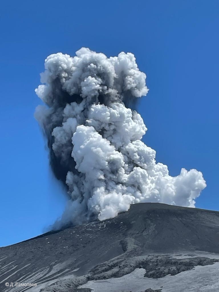
Volcanic Activity Summary:
A moderate explosive activity of the volcano continues. According to visual data by volcanologists from Severo-Kurilsk, an explosion sent ash up to 1.9 km a.s.l., an ash cloud is drifting to the south-east of the volcano.
A moderate eruptive activity of the volcano continues. Ash explosions up to 6 km (19,700 ft) a.s.l. could occur at any time. Ongoing activity could affect low-flying aircraft and airport of Severo-Kurilsk.
Volcanic cloud height:
1900 m (6232 ft) AMSL Time and method of ash plume/cloud height determination: 20221204/2337Z – Visual data
Other volcanic cloud information:
Distance of ash plume/cloud of the volcano: 5 km (3 mi)
Direction of drift of ash plume/cloud of the volcano: SE
Source : Kvert.
Photo : D. Ermolaev.
Guatemala , Fuego :
Activity:
The Fuego Volcano Observatory -OVFGO- reports that activity was observed in the crater at night and early in the morning with weak, moderate and sometimes strong explosions, in a range of 5 to 8 per hour, expelling columns of ashes at an approximate height of 4,500 to 4,800 meters above sea level (14,763 – 15,748 feet) that the wind disperses over 30 km in a west and southwest direction. Strombolian activity is maintained with glowing pulses at a height of between 200 meters above crater level.
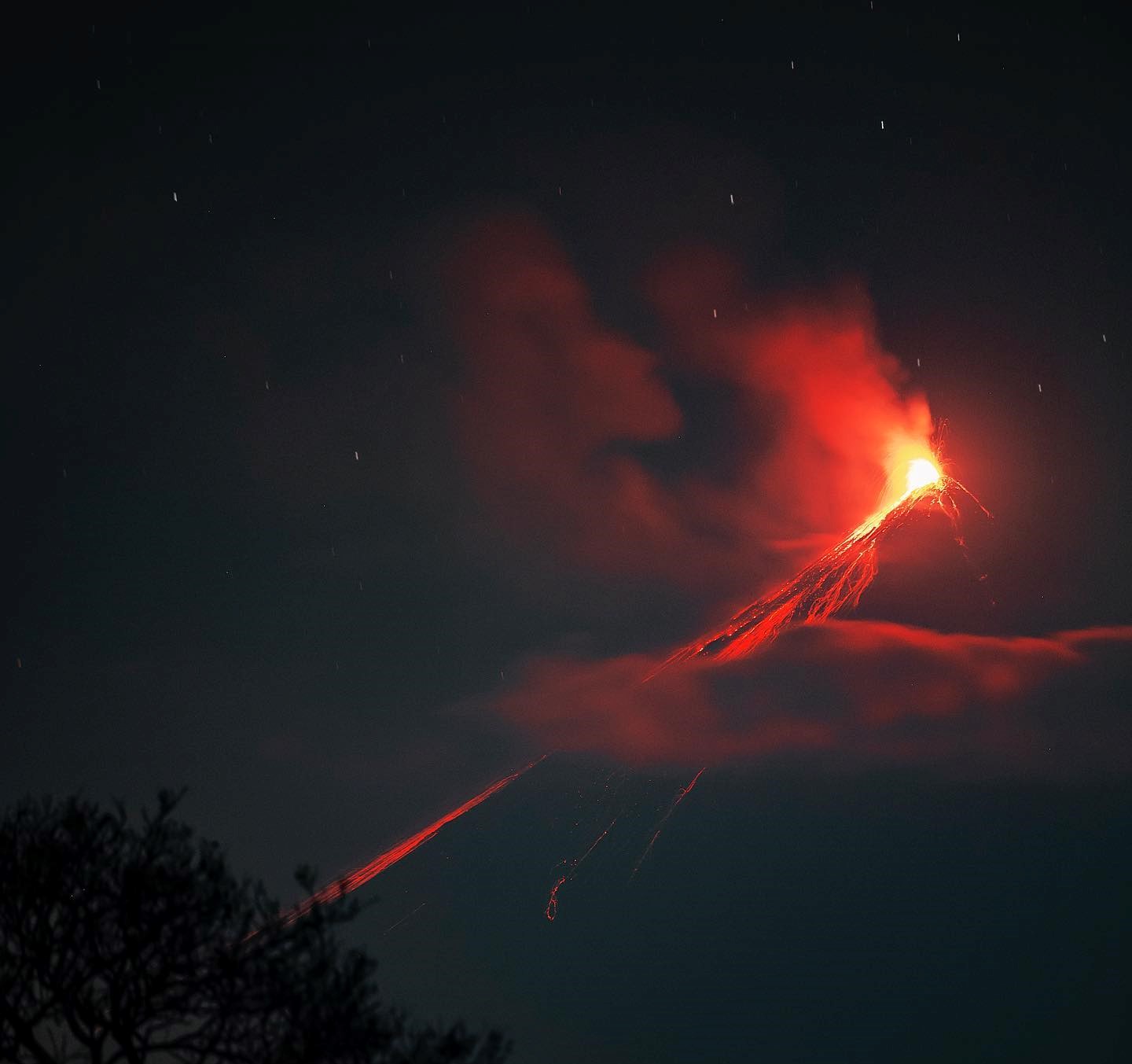
The explosions generate weak to moderate avalanches from the crater rim, towards the ravines of Ceniza, Santa Teresa, Las Lajas and Trinidad. Moderate to strong explosions generate rumblings and shock waves that shake the roofs and houses of the villages near the volcano. Ash falls are reported in Panimache I and II, Morelia, Santa Sofía, Yucales. Due to the speed of the wind, the ashes are sometimes lifted, forming curtains of ash on the South and Southwest flanks, which could be redeposited in towns such as Santa Lucia Cotz and other communities located to the West. of the Fuego volcano. Sounds similar to a train locomotive are reported with a duration of 2 to 6 minutes.
Source : Insivumeh.
Photo : Diego Rizzo