October 20 , 2022.
Indonesia , Kerinci :
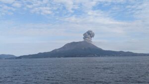
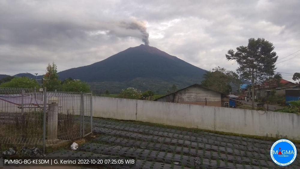
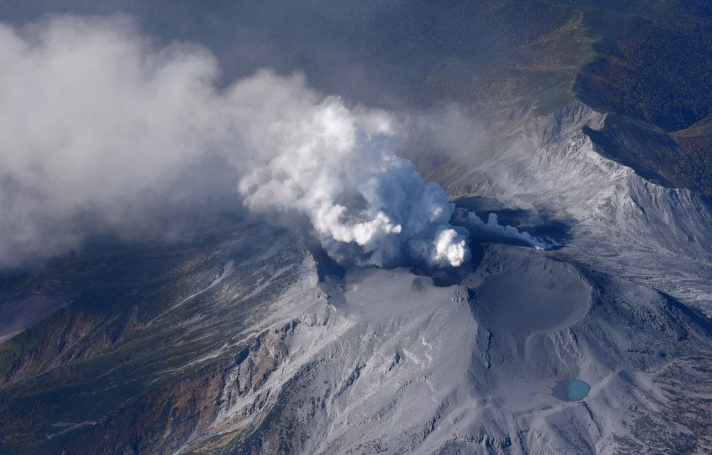
Mount Kerinci erupted on Thursday, October 20, 2022 at 07:03 WIB with an ash column height observed at ± 750 m above the summit (± 4555 m above sea level). The ash column is observed to be gray with moderate intensity to the northwest. This eruption was recorded on a seismograph with a maximum amplitude of 2 mm and a duration of 600 seconds.
VOLCANO OBSERVATORY NOTICE FOR AVIATION – VONA
Issued : October 20 , 2022.
Volcano : Kerinci (261170)
Current Aviation Colour Code : ORANGE
Previous Aviation Colour Code : orange
Source : Kerinci Volcano Observatory
Notice Number : 2022KER04
Volcano Location : S 01 deg 41 min 49 sec E 101 deg 15 min 50 sec
Area : Jambi, West Sumatra, Indonesia
Summit Elevation : 12176 FT (3805 M)
Volcanic Activity Summary :
Eruption with Volcanic ash cloud at 12h03 UTC (06h03 lokal)
Volcanic Cloud Height :
Best estimate of ash-cloud top is around 14576 FT (4555 M) above sea level, may be higher than what can be observed clearly. Source of height data: ground observer.
Other Volcanic Cloud Information :
Ash-cloud moving to Northwest
Remarks :
Seismic activity by contiuous volcanic tremor
PVMBG reported that white-and-black plumes from Kerinci rose as high as 350 m above the summit and drifted NE during 15-16 October. Two VONAs were posted on 19 October; at 0620 on 19 October an ash plume rose 500 m above the summit and drifted NW, and at 0815 an ash plume rose 700 m and drifted NW. The Aviation Color Code was raised to Orange (the second highest level on a four-color scale). The Alert Level remained at 2 (on a scale of 1-4), and the public was warned to remain outside of the 3-km exclusion zone.
Source : Magma Indonésie , GVP.
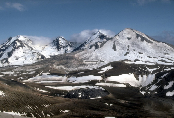
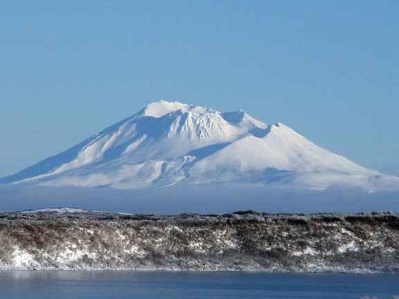
Alaska , Trident / Ugashik-Peulik / Ukinrek Maars :
Trident :
Current Volcano Alert Level: NORMAL
Previous Volcano Alert Level: ADVISORY
Current Aviation Color Code: GREEN
Previous Aviation Color Code: YELLOW
Issued: Wednesday, October 19, 2022, 2:06 PM AKDT
Source: Alaska Volcano Observatory
Notice Number: 2022/A1190
Location: N 58 deg 14 min W 155 deg 6 min
Elevation: 3599 ft (1097 m)
Area: Alaska Peninsula
Volcanic Activity Summary:
The swarm of earthquakes that began on August 24, 2022, beneath Trident Volcano has subsided and seismic tremor has not been observed since September 30, 2022. Occasional local earthquakes continue to be detected at background levels. Due to this decrease in activity and the absence of other signs of unrest, we are lowering the Aviation Color Code to GREEN and the Volcano Alert level to NORMAL.
Should activity increase, AVO will issue further notices. AVO monitors Trident with a local network of seismometers, a webcam, remote sensing data, and regional infrasound and lightning networks.
UGASHIK-PEULIK :
57°45’1″ N 156°22’12 » W,
Summit Elevation 4836 ft (1474 m)
Current Volcano Alert Level: UNASSIGNED
Current Aviation Color Code: UNASSIGNED
Aviation color code and alert level changed to GREEN/NORMAL due to the restoration of communication with seismic stations.
The Ugashik-Peulik volcanic complex lies south of Becharof Lake and east of Upper Ugashik Lake. Late-Pleistocene caldera formation was followed by the emplacement of at least five Holocene lava domes within the 4.5-km-wide caldera. Most of the caldera walls consist of basement sandstones of Jurassic age. Following caldera formation the small, 3 km3 Peulik stratovolcano grew 2.5 km to the N. Lava flows from Peulik cover the caldera rim to the south and extend to Becharof Lake, 6 km N. A small lava dome on the E flank of Peulik was the source of a small block-and-ash flow. The summit of Peulik contains a 1.5-km-wide crater breached to the west that is partially filled by a lava dome. Debris-avalanche deposits cover a 75 km2 area to the NW. A single documented historical eruption took place from Peulik in 1814.
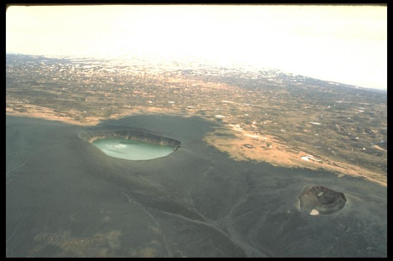
UKINREK MAARS :
57°50’2″ N 156°30’50 » W,
Summit Elevation 299 ft (91 m)
Current Volcano Alert Level: UNASSIGNED
Current Aviation Color Code: UNASSIGNED
Aviation color code and alert level changed to GREEN/NORMAL due to the restoration of communication with seismic stations.
Ukinrek Maars are two explosion craters that were created in an area without previous volcanic activity during a 10-day phreatomagmatic eruption March-April 1977. The basaltic maars were erupted through glacial deposits in the Bering Sea lowlands 1.5 km S of Becharof Lake and 12 km W of Peulik volcano; their location is related to the regional Bruin Bay fault. The elliptical West Maar, which was the first to form, is 105 x 170 m wide and 35 m deep. The other maar, 600 m to the east, is 300 m wide and 70 m deep. Both maars are now filled by crater lakes; the eastern lake encircles a 49-m-high lava dome that was emplaced at the end of the eruption. Base surges were directed primarily to the NW. Juvenile material from the Ukinrek eruptions was of mantle-derived olivine basaltic composition. The dacitic Gas Rocks lava domes, of Quaternary age, are located on the shores of Becharof Lake, 3 km N of Ukinrek maars and were the site of a phreatic eruption about 2,300 years ago.
Source : AVO / GVP.
Photos : McGimsey, R. G./ Alaska Volcano Observatory/U.S. Geological Survey , Dreeszen, Robert , Dewhurst, Donna .
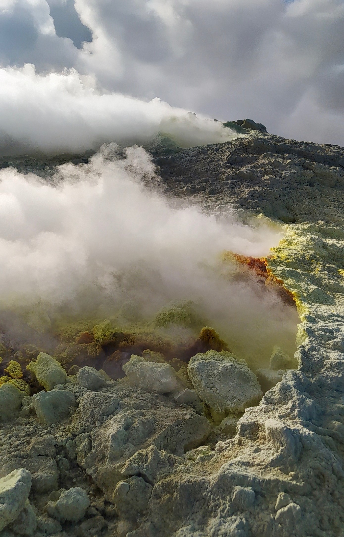
Italy , Vulcano :
WEEKLY BULLETIN, from October 10, 2022 to October 16, 2022, (issue date October 18, 2022)
ACTIVITY STATUS SUMMARY
In the light of the surveillance data, it is highlighted:
1) Temperature of the crater fumaroles: Along the upper edge, the maximum emission temperature has stable and high values, around 375°C.
2) CO2 flux in the crater area: The CO2 flux in the crater area remains at medium-high values.
3) SO2 flux in the crater area: stable at a moderately medium-high level
4) Geochemistry of fumarolic gases: There are no updates.
5) CO2 fluxes at the base of the La Fossa cone and in the Vulcano Porto area: The CO2 fluxes recorded in the Rimessa, C. Sicilia sites always show values above background levels. The P4max site displays medium to high values, while at the Faraglione site there are values close to the background level.
6) Geochemistry of thermal aquifers: in the well of Camping Sicilia there are always high values of temperature and conductivity at medium-low levels; in the Bambara well, the level and conductivity values show no significant variations.
7) Local seismicity: There are no significant variations in the rate of occurrence of local micro-shocks.
8) Regional seismicity: Absence of regional earthquakes of local magnitude equal to or greater than 1.0
9) Deformations – GNSS: No significant variation is observed in the time series of the GNSS stations.
10) Deformations – Inclinometry: No significant variation of the inclination data.
11) Gravimetry: There are no significant medium-long term changes.
12) Other Notes: Mobile GNSS. The GNSS mobile network acquires and transmits movements in real time at a frequency of 1 Hz. The time series acquired so far do not show significant variations around the Porto di Levante area.
CRATER FUMEROLES TEMPERATURE:
Along the upper edge, the maximum emission temperature has extremely stable values, with an hourly maximum of 375°C (T1). The fumarolic field has homogeneous emission temperatures along the summit fracture line, confirming a thermal anomaly maintained by a stable vapor flow. The thermal signal from the FT3 sensor (F5AT fumarole) is inserted between the temperatures recorded in FT1 and FT2 (these 2 probes are located in the F5AT fumarole). The total range of hourly temperatures recorded on board is between 351 and 375°C. Data loss is observed at night due to backup battery failure.
Source : INGV.
Photo : G. De Astis (INGV-Rome1)
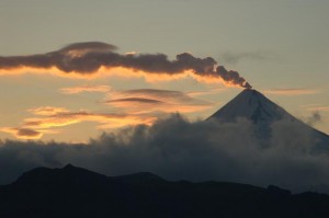
Japan , Suwanosejima :
JMA reported that the eruption at Suwanosejima’s Ontake Crater continued during 10-17 October. A total of 71 explosions produced eruption plumes that rose as high as 2 km above the crater rim and ejected blocks as far as 600 m from the vent. Crater incandescence was visible nightly. Occasional ashfall was reported in Toshima village (3.5 km SSW) during the first half of the week. The Alert Level remained at 2 and the public was warned to stay 1 km away from the crater.
The 8-km-long island of Suwanosejima in the northern Ryukyu Islands consists of an andesitic stratovolcano with two historically active summit craters. The summit is truncated by a large breached crater extending to the sea on the east flank that was formed by edifice collapse. One of Japan’s most frequently active volcanoes, it was in a state of intermittent Strombolian activity from Otake, the NE summit crater, between 1949 and 1996, after which periods of inactivity lengthened. The largest recorded eruption took place in 1813-14, when thick scoria deposits blanketed residential areas, and the SW crater produced two lava flows that reached the western coast. At the end of the eruption the summit of Otake collapsed, forming a large debris avalanche and creating the open Sakuchi caldera, which extends to the eastern coast. The island remained uninhabited for about 70 years after the 1813-1814 eruption. Lava flows reached the eastern coast of the island in 1884. Only about 50 people live on the island.
Source : Agence météorologique japonaise (JMA) , GVP.
Photo : ontake , Masanori Genko.
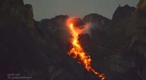
Guatemala , Santiaguito :
Activity:
The Observatory of the Santa María-Santiaguito Volcanic Complex reports moderate degassing fumaroles 600 meters above the Caliente dome, which are moving southwest, as well as steam from the active lava flow. This vapor is accompanied by a faint smell of sulfur perceptible on certain farms south of the dome. Incandescences were observed on the dome and avalanches descending on the western and southern flanks. Activity ahead of the active lava flow in the San Isidro and El Tambor channels continues with some boulder collapses, which generate ash clouds up to several hundred meters high.
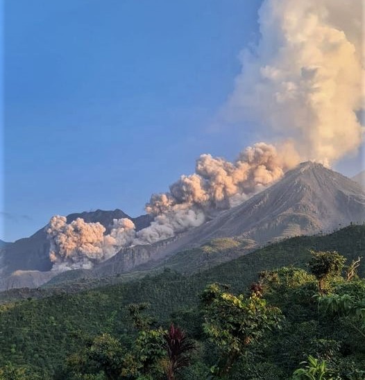
It is recommended not to approach the lava flow, due to the intense heat it emits and the constant collapses that occur on its edges, which could cause burns and other serious injuries to those who come close. Extrusive activity remains at a high level and continues to accumulate unstable material in the lava flow, in the San Isidro and El Tambor channels, as well as in the Caliente dome, so it remains possible that some of this collapses of materials and long-distance pyroclastic flows are generated in the South-West, South and East.
Source : Insivumeh.
Photo : Edgar Cabrera / CONRED