October 13 , 2022.
Italy , Stromboli :
Statement on the activity of STROMBOLI, October 12, 2022, 13:28 (11:28 UTC).
The National Institute of Geophysics and Volcanology, Osservatorio Etneo, announces that through the images of the surveillance cameras and the observations on the ground made by the personnel of the INGV, the eruptive scenario is stable and does not show any specific variation by compared to what was reported in the October 11 press release. Effusive activity shows moderate and variable feeding with the most advanced fronts remaining at an altitude of around 400 m.
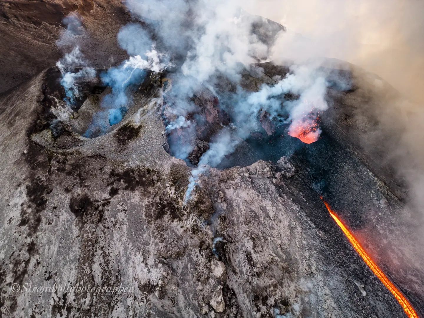
The pulsating regime of the lava effusion causes frequent collapses and detachments of material from the lava channel eroded by the flows and from the front itself which rolls along the Sciara del Fuoco, quickly reaching the coast flowing into the sea. Regarding the ordinary explosive activity, it does not show any particular variations and the projection activity at the North crater persists.
From the seismic point of view, the average amplitude of the volcanic tremor showed slight fluctuations, almost always and up to the current state in the medium-low level.
Since the last update, data from deformation monitoring networks on the island show no significant changes.
Further updates will be communicated soon.
Source : INGV
Photo : Stromboli stati d’animo
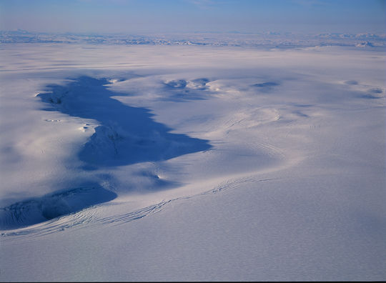
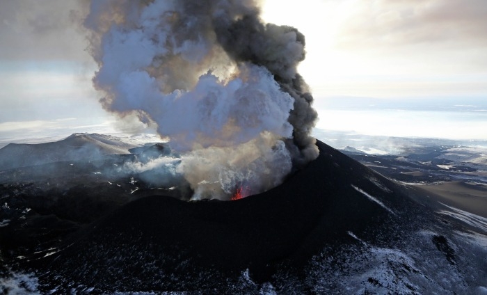
Iceland , Grímsvötn :
Measurements from the Institute of Earth Sciences at the University of Iceland indicate that water has started flowing from Grímsvötn into the Vatnajökull glacier and a glacial flood is expected in the Gígjukvísl river. The ice cap has retreated nearly 3m in the past few days, but the water level is low at Grímsvötn, so a small flood is expected, one-fifth the volume of the last flood. Flooding is most likely to start in Gígjukvísl tomorrow, Tuesday, and last for several days. If the subglacial Lake Grímsvötn drains completely, the ice shelf can probably sink about 10 to 15 m in total.
Volcanic activity closely monitored
There are examples of volcanic eruptions on Grímsvötn coinciding with glacial floods. It is likely that the sudden relief of pressure due to lower water levels could trigger eruptions. The last time such a scenario occurred was in 2004, and before that in 1934 and 1922. However, Grímsvötn has had much more frequent flooding without an eruption. However, the flight color code for Grímsvötn has been changed to yellow due to the flooding, as it is difficult to rule out the possibility of an eruption starting as a result, although this is considered unlikely. Two things have to happen; The pressure relief must be sufficient to « trigger » and reawaken the volcano, and the magma pressure within the volcano must be sufficient to trigger an eruption, but there is uncertainty on both aspects. Maximum pressure relief on the Grímsvötn can be expected on Wednesday, when the flood reaches its peak, and with it an increased risk of an eruption, which will decrease rapidly after the flood.
Icelandic Meteorological Office (IMO) reported that recent GPS measurements indicated that the ice sheet had subsided about 3 m and the lake beneath the glacier at Grímsvötn had begun to drain, though the water had not reached the glacier’s margins. IMO forecasted a small jökulhlaup and raised the Aviation Color Code to Yellow (the second lowest level on a four-color scale) on 10 October. The report noted that neither seismicity nor gas emissions were elevated, though activity at the volcano had been increasing over time. Notably, a pulse of seismic tremor was recorded for about an hour during the previous week, and magmatic gases were measured in fumarolic plumes in 2020. By 12 October the outflow of water was about 300 cubic meters per second, with the onset of the jökulhlaup occurring slower than initially calculated, and the ice sheet had subsided a total of 7 m. The flooding was likely going to be equal to that seen during the summer and would likely not impact bridges or structures.
Source : Vedur is , GVP
Photo : Veðurstofa Íslands/Oddur Sigurðsson)
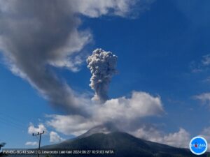
Russia / Kurils Islands , Ebeko :
VOLCANO OBSERVATORY NOTICE FOR AVIATION (VONA)
Issued: October 13 , 2022
Volcano: Ebeko (CAVW #290380)
Current aviation colour code: ORANGE
Previous aviation colour code: orange
Source: KVERT
Notice Number: 2022-129
Volcano Location: N 50 deg 41 min E 156 deg 0 min
Area: Northern Kuriles, Russia
Summit Elevation: 1156 m (3791.68 ft)
Volcanic Activity Summary:
A moderate eruptive activity of the volcano continues. According to visual data by volcanologists from Severo-Kurilsk, explosions sent ash up to 4 km a.s.l., an ash cloud is drifting to the east of the volcano; an ashfall is observing at Severo-Kurilsk.
A moderate eruptive activity of the volcano continues. Ash explosions up to 6 km (19,700 ft) a.s.l. could occur at any time. Ongoing activity could affect low-flying aircraft and airport of Severo-Kurilsk.
Volcanic cloud height:
3500-4000 m (11480-13120 ft) AMSL Time and method of ash plume/cloud height determination: 20221013/0523Z – Visual data
Other volcanic cloud information:
Distance of ash plume/cloud of the volcano: 5 km (3 mi)
Direction of drift of ash plume/cloud of the volcano: E
Time and method of ash plume/cloud determination: 20221013/0523Z – Visual data
Source : Kvert.
Photo : Yuri Demyanchuk
Iles Tonga , Home Reef :
The Geological Survey of Tonga reported that daily steam plumes from Home Reef were identified in satellite imagery from October 4-11. The Aviation Color Code was raised to Orange (the second highest level on a four-color scale) on October 5. At 12:40 a.m. on October 6, an ash plume rose up to 3 km (10,000 ft) above sea level and drifted 5 km to the southeast. Satellite measurements showed that the island had not changed in size between September 28 and October 10, remaining at 268 m North-South and 283 m East-West. The island reached 15 to 18 m above the water surface and was steeper on the eastern half but more gently sloping on the west. The number of daily broadcasts was variable with around 8-19 events per day from October 4-9 and around 1-3 per day from October 10-11. The Aviation Color Code was lowered to yellow on October 11. Navigators were advised to stay 4 km from the volcano.
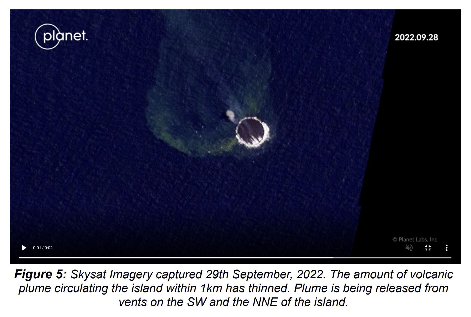
Home Reef, a submarine volcano midway between Metis Shoal and Late Island in the central Tonga islands, was first reported active in the mid-19th century, when an ephemeral island formed. An eruption in 1984 produced a 12-km-high eruption plume, copious amounts of floating pumice, and an ephemeral island 500 x 1500 m wide, with cliffs 30-50 m high that enclosed a water-filled crater. Another island-forming eruption in 2006 produced widespread dacitic pumice rafts that reached as far as Australia.
Source : Tonga Geological Services, Government of Tonga , GVP.
Photo : Skysat / tonga geological service
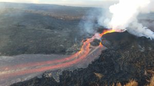
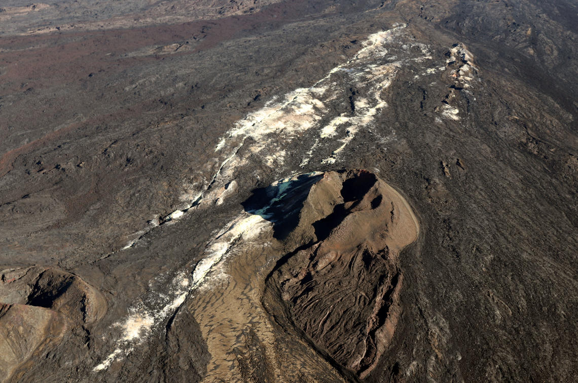
Hawaii , Mauna Loa :
19°28’30 » N 155°36’29 » W,
Summit Elevation 13681 ft (4170 m)
Current Volcano Alert Level: ADVISORY
Current Aviation Color Code: YELLOW
Activity Summary:
Mauna Loa is not erupting and there are no signs of an imminent eruption at this time. However, Mauna Loa continues to be in a state of heightened unrest as indicated by increased earthquake activity and inflation of the summit. The current unrest is most likely being driven by renewed input of magma 2-5 miles (3-8 km) beneath Mauna Loa’s summit. Monitoring data show no significant changes in the past day and conditions remain similar to those reported for the past week.
Observations:
During the past 24 hours, HVO detected 65 small-magnitude (below M3.0) earthquakes 2-3 miles (3-5 km) below Mokuāʻweoweo caldera and 4-5 miles (6-8 km) beneath the upper-elevation northwest flank of Mauna Loa. Both of these regions have historically been seismically active during periods of unrest on Mauna Loa.
Global Positioning System (GPS) instruments at the summit and on the flanks of Mauna Loa continue to measure inflation at rates elevated since mid-September. However, tiltmeters at the summit are not showing significant surface deformation over the past week.
Concentrations of sulfur dioxide (SO2), hydrogen sulfide (H2S), and carbon dioxide (CO2), as well as fumarole temperatures, remain stable at the summit and at Sulphur Cone on the upper Southwest Rift Zone. Webcam and thermal camera views have shown no changes to the volcanic landscape on Mauna Loa over the past week.
On 5 October HVO noted recent increases in seismicity and deformation at Mauna Loa. The number of earthquakes increased from 5-10 per day in June to 10-20 per day during July-August. The number of daily earthquakes again intensified, to 40-50 per day, starting at about 0200 on 23 September, and peaks as high as 100 per day were recorded on 23 and 29 September. The small-magnitude (less than M3) earthquakes occurred beneath Moku‘aweoweo, the summit caldera, at depths of 2-3 km. Inflation accompanied the swarm and had also increased during the past two weeks.
Daily earthquake counts were relatively unchanged during 6-12 October. Data from Global Positioning System (GPS) instruments at the summit and flanks showed continuing inflation, though data from tiltmeters at the summit did not show significant surface deformation over the past week. Earthquakes were clustered beneath the summit caldera at depths of 3-5 km and below the NW flank at depths of 6-8 km. The Volcano Alert Level remained at Advisory (the second lowest level on a four-level scale) and the Aviation Color Code remained at Yellow (the second lowest level on a four-color scale).
Source : HVO , GVP.
Photo : USGS.