October 12 , 2022.
Italy , Stromboli :
Press release on the activity of STROMBOLI, October 11, 2022, 18:26 (16:26 UTC).
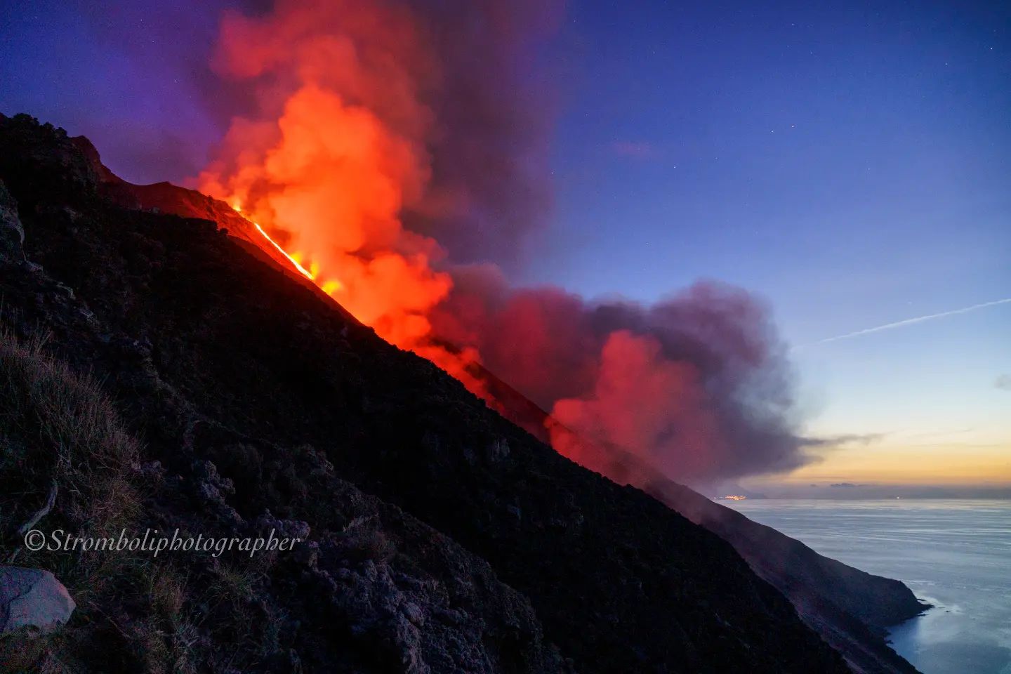
The National Institute of Geophysics and Volcanology, Osservatorio Etneo, announces that according to ground observations made by INGV staff at the end of the morning, it appears that the eruptive scenario described in the previous press release remains almost unchanged. Indeed, the lava flows continue to be poorly fed and the fronts have not advanced since the last press release. Frequent collapses and detachments of material from the lava channel eroded by the flows and from the front itself which rapidly reach the sea continue to be observed.

Finally, spatter activity at the North Crater persists.
From the seismic point of view, during the day today, the average amplitude of the volcanic tremor showed modest fluctuations, almost always up to the current state in the medium-low level.
Data from deformation monitoring networks on the island show no significant changes since the last release.
Further updates will be communicated soon.
WEEKLY BULLETIN, from October 03, 2022 to October 09, 2022, (issue date October 11, 2022)
ACTIVITY STATUS BULLETIN SUMMARY
In the light of the surveillance data, it is highlighted:
1) VOLCANOLOGICAL OBSERVATIONS: During this period, normal Strombolian-type explosive activity with spattering activity and three lava overflows with pyroclastic flow from the North Crater area were observed. The total hourly frequency oscillated between low values (4 events/h) and average (12 events/h). The intensity of the explosions was low and medium in the North crater area while it was medium in the Center-South crater area.
2) SEISMOLOGY: The seismological parameters do not show significant changes, except for the increase in tremor in correspondence with the pyroclastic flow of 9/10 at 07:22 (UTC).
3) GROUND DEFORMATIONS: There are 2 slight tilt variations on October 4 (0.1-0.2 microradians) and October 9 (0.05 microradians) between 07:17 UTC and 07:24. There are no significant variations on the SVIN-TDF distance measured by the GNSS network.
4) GEOCHEMISTRY: SO2 flux at an average level.
CO2 fluxes in the crater area remain at average values (about 8500 g/m2*g). The C/S ratio in the plume is at average values (C/S = 8.4).
There are no updates on the isotope ratio of helium in groundwater.
5) SATELLITE OBSERVATIONS: Thermal activity observed by satellite in the summit area was moderate to high.
VOLCANOLOGICAL OBSERVATIONS
In the period under observation, the eruptive activity of Stromboli was characterized by the analysis of the images recorded by the surveillance cameras of the INGV-OE at an altitude of 190m (SCT-SCV) which were restored on September 21 2022 and Punta dei Corvi, and through field observations by INGV staff under the UN Departmental Project and Annex A-DPC. The cameras at altitude 400m and Pizzo due to problems acquiring video signals caused by damage to the optical fiber connecting Punta Labronzo and COA due to the bad weather that hit the island on August 12, 2022, are not not available at the moment.
The explosive activity was mainly produced by 3 (three) eruptive vents located in the North crater area and by at least 2 (two) eruptive vents located in the Center-South crater area. All vents are placed within the depression that occupies the crater terrace.
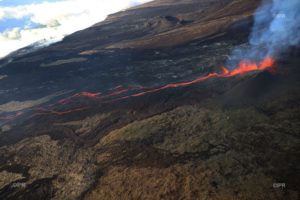
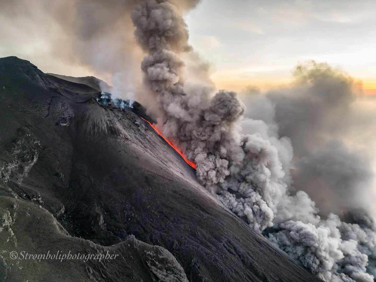
On October 3 and 4, 2022, two lava flows were emitted from the northern area of the crater, while on October 9, a lava overflow followed by a pyroclastic flow occurred from the same area of the crater.
Lava flows of October 3 and 4, 2022
At 09:08:56 UTC, from a fracture on the outer cone of sector N2 inside the Sciara del fuoco, a lava flow begins, which gradually increases in volume, forming a lava channel that s ‘extends along the Sciara until it reaches the coast, as evidenced by the bright spot clearly visible from 10:10 UTC. The lava flow appears to cool around 4:00 p.m. UTC. On October 4, from 09:07 UTC, a new lava overflow is observed from the North crater which overlaps that of the day before. Such an overflow causes material to roll along the Sciara del fuoco and remains confined to the upper part of the Sciara, cooling within hours.
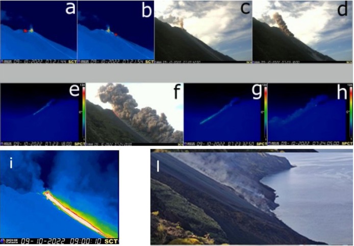
Fig.3.3 (a-b) Images of the pyroclastic flow taken by the infrared camera at altitude 190 (SCT), by the visible camera at altitude 190 (SCV; c-d-f) and by the infrared camera at Punta dei Corvi (SPCT ; e-g-h). In (i) lava flow captured by the camera of 190 (SCV) and thanks to field observations by INGV staff (l)
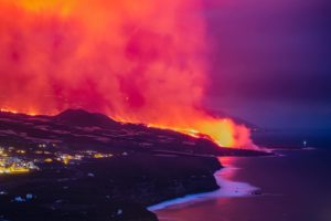
Lava overflow and pyroclastic flow of October 9, 2022
On October 9, 2022, a lava overflow followed by a pyroclastic flow occurred from the northern zone of the crater of sector N2. At 07:21:44 an overflow of lava begins from the northern part of sector N2 (Fig.3.3 a) which is followed at 07:21:54 by a fracture placed on the outer cone of sector N2 inside from the Sciara del fuoco, already the emission point of the October 3 flow, a weak lava flow begins to spread (Fig. 3.3 b). At 07:22:42 a pyroclastic flow begins with the collapse of the edge of sector N2 overlooking the Sciara del fuoco. The flow spreads rapidly in about 30 seconds along the Sciara del fuoco (Fig. 3.3 c-d-e-f), reaching the coast at 07:23:32 and spreading over the sea for a few hundred meters (Fig. 3.3 g-h) . The pyroclastic flow is immediately followed by a vigorously well-fed lava flow, developing into two main arms and pouring into the sea after a few minutes (Fig 3.3 i, l) Throughout the day of October 9, the flow lava was still active.
Observations of explosive activity captured by surveillance cameras.
Sector N1, located in the area of the North crater, produced explosions of low intensity (less than 80 m high) to medium (less than 150 m high) emitting coarse materials (bombs and lapilli). Sector N2, with two emission points, showed explosive activity of medium intensity, emitting coarse materials and continuous projection activity that was very intense for long periods from both mouths. The average frequency of explosions varied from 3 to 6 events/h.
In the Center-South zone, it was not possible to discriminate between the different sectors due to the close framing of the cameras at an altitude of 190m towards the CS crater zone. In this crater area, with at least two emission points, explosions of mainly medium intensity (less than 150 m) emitting coarse material from one vent and fine material (ash) from the other vent were observed. The frequency of explosions varied between less than 1 and 6 events/h.
Source : INGV.
Photos : INGV , Stromboli Stati d’animo .
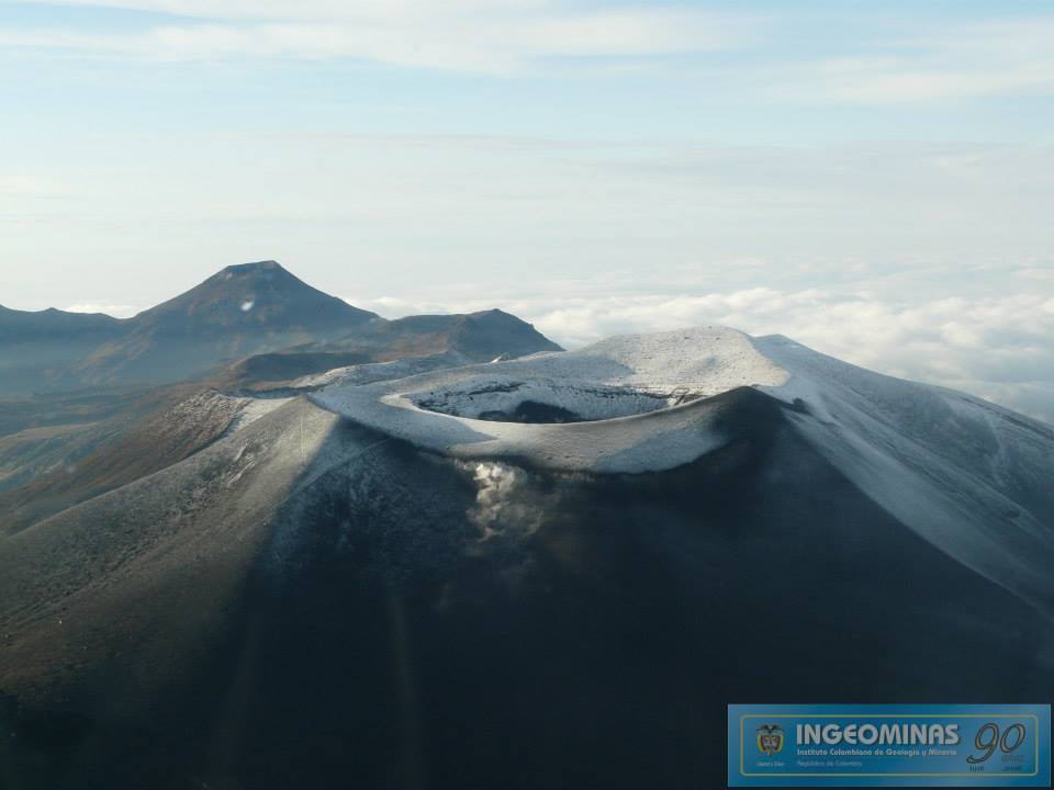
Colombia , Puracé / Chaîne volcanique Los Coconucos :
Weekly bulletin of the activity of the Puracé volcano – Los Coconucos volcanic chain.
The activity level of the volcano continues at the Yellow Activity Level or (III): changes in the behavior of volcanic activity.
From the analysis and evaluation of the information obtained through the monitoring network of the Puracé volcano – Los Coconucos volcanic chain, during the week of October 4 to 10, 2022, the COLOMBIAN GEOLOGICAL SERVICE – Volcanological and Seismological Observatory of Popayan reports that:
With regard to the seismic activity recorded, there were no notable variations in terms of the number of events and the energy released. Of a total of 1,521 seismic events recorded, 315 were associated with rock fracturing processes (type VT) and 1,206 with fluid dynamics in volcanic conduits.
The geodetic network of GNSS (Global Navigation Satellite System) stations monitoring ground deformation continues to record a process related to inflation.
By monitoring the surface activity with the images obtained during the week thanks to the Anambío, Mina, Lavas Rojas, Cerro Sombrero and Curiquinga web cameras, a degassing of the volcanic system was highlighted, with a white column oriented preferentially towards the North-west.
Regarding volcanic gas monitoring, sulfur dioxide (SO2) flux emissions recorded by telemetric stations continue to show changes in the flux, with a maximum emitted of 508 t/day for the week assessed, this which marks a decrease compared to the immediate preceding week. The other instruments for measuring carbon dioxide (CO2) and radon gas (222Rn) in the area of volcanic influence record considerable variations in their concentrations for the period evaluated, which is normal in active volcanic systems.
Magnetic field and infrasonic wave monitoring sensors did not record variations associated with changes in volcanic activity.
It is concluded from the above that variations in volcanic activity continue to be recorded, consistent with the behavior expected at activity level III (yellow level), which could evolve towards states of greater activity.
Source : SGC.
Photo : Ingeominas.
Chile , Nevados de Chillan :
Seismology
The seismological activity of the period was characterized by the recording of:
125 volcano-tectonic (VT) earthquakes associated with brittle rupture processes; the most energetic earthquake had a local magnitude (ML) equal to 2.1, the location of which was estimated with a depth of 4.0 km and an epicentral distance of 4.8 km East-South -Is relative to the active crater. It should be noted that most of the recordings of volcano-tectonic type earthquakes were concentrated epicentrally very close to the active crater (distances <1Km) and with low energies, corresponding for the most part to local magnitudes less than or equal to 1. moreover, hybrid earthquakes – type events (HB) associated with brittle rupture processes associated with magmatic fluid movements were recorded, with a total of 108 earthquakes, mainly with low energies corresponding to local magnitudes less than 1 and a spatial distribution with epicentres close to the active crater.
Long period (LP), explosion (EX) and tremor (TR) seismicity continued to be recorded, associated with fluid dynamics within the volcanic system. 629 LP-type earthquakes were classified, of which 66 were related to explosions at surface level, due to the presence of acoustic waves and/or gaseous emissions, specifying that the recording of the two characteristics mentioned is difficult due to adverse weather conditions, which may lead to a decrease from the ideal count for this type of event. The size of the largest LP earthquake estimated from the reduced displacement parameter (DR) reached a value equal to 740 cm2, whose seismic energy is one of the largest detected throughout the eruptive cycle. This earthquake occurred during an increase in explosive activity on September 17 and 19, which included 2 additional notable events to the one mentioned, all with a significant release of seismic energy as well as acoustic energy, the most important of them with a reduced acoustic pressure at 1 Km of 165 Pa Km. After the explosive period, a decrease in the daily seismic energy of the fluids is observed in a manner similar to what happened after the explosion of 9/29. Regarding TR type seismicity, 132 episodes were recorded, the most important of which reached a DR of 203 cm2.
Surveillance cameras
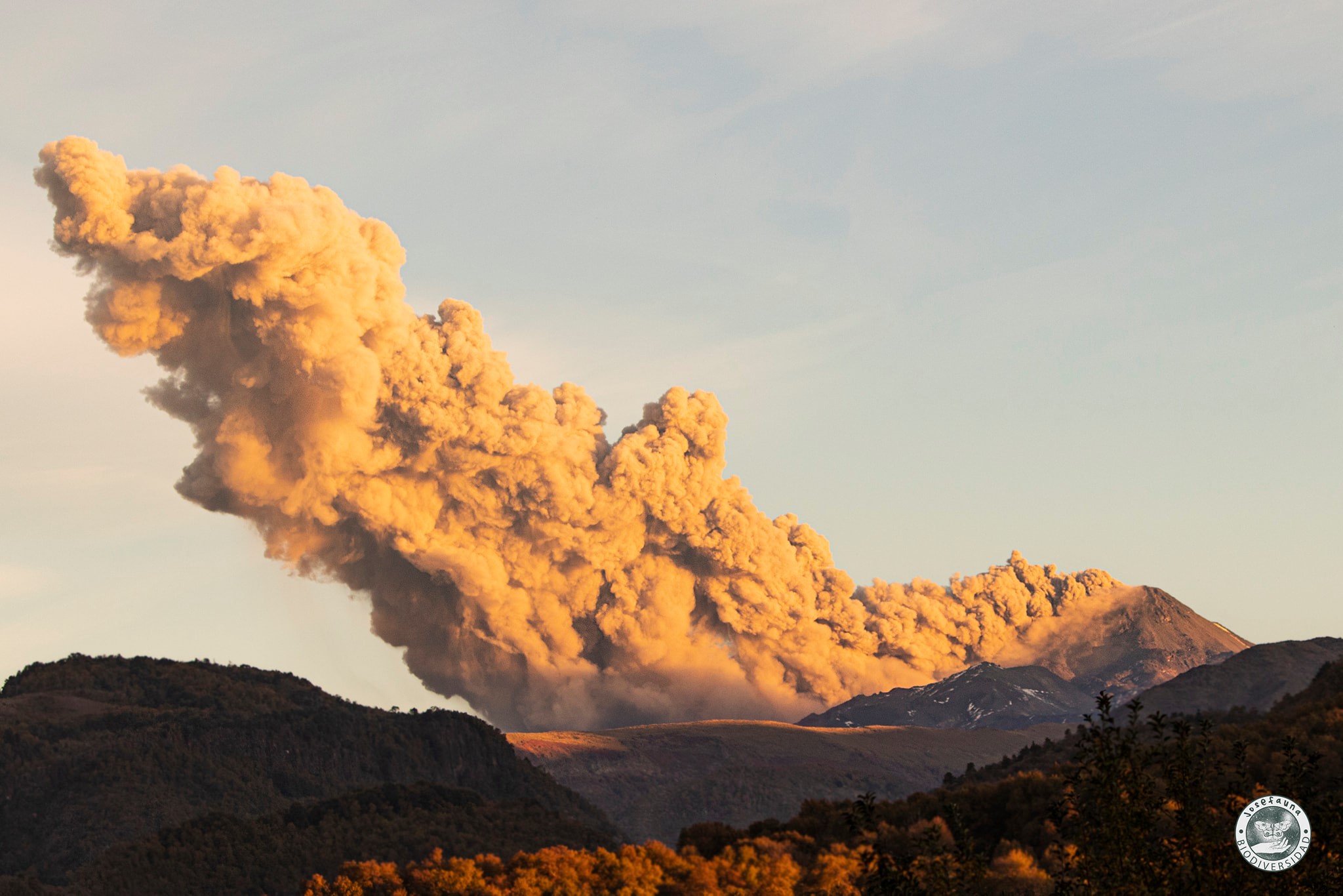
According to the surveillance cameras, explosions of moderate pyroclastic charge with events dominated by gases such as water vapor, with the generation of eruptive columns mainly between 500 and 1000 meters high, have been recorded. In particular, on September 16, 19 and 30, explosions were recorded that generated eruptive columns with a strong charge of pyroclasts over 360 meters high. Two explosions that occurred on September 19 stand out, the first generated an eruptive column 1,100 meters high, dispersing towards the Southeast, which was affected by ballistic blocks on the western slope, with a maximum range of 500 meters from the edge of the crater. The second explosion generated an incandescent eruptive column 1,700 meters high (the highest recorded in this period), which dispersed to the southeast, forming an ash fall deposit in the same direction. Finally, the explosive activity of the second fortnight generated ash deposits to the southeast, landslides and ballistic projections on the western slope.
Satellite geomorphological analysis
From geomorphological observations made on Planet Scope and Sentinel 2 L2A satellite images, it is observed that Dome 4 was growing until the middle of the month, associated with lava extrusion, which spatially coincides with the anomaly. of thermal radiation seen on Sentinel 2. L2A images in false colors. However, during the second half of the month, an absence of thermal radiation is observed in the crater area towards the end of the month, interpreted as a partial obstruction of the surface feeding system. Note that the explosions that occurred on September 19 generated a partial destruction of Dome 4.
Source : Sernageomin.
Read the full article : https://rnvv.sernageomin.cl/rnvv/TI_Santiago_prod/reportes_LB/2022/RAV_20221011_%C3%91uble_v18.pdf
Photo : Josefauna .
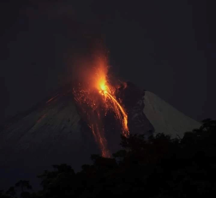
Ecuador , Sangay :
DAILY REPORT OF THE STATE OF SANGAY VOLCANO, Tuesday October 11, 2022.
Information Geophysical Institute – EPN.
Surface Activity Level: High, Surface Trend: No change
Internal activity level: High, Internal trend: No change.
Seismicity: From October 10, 2022, 11:00 a.m. to October 11, 2022, 11:00 a.m.:
The data from the reference seismic station correspond to 21 hours of transmission.
Explosion (EXP) 733
Emission Tremors (TREMI ) 51.
Rains / Lahars:
No rain was recorded in the area. **In the event of heavy rains, these could remobilize the accumulated materials, generating mudslides and debris that would descend on the flanks of the volcano and flow into the adjacent rivers.**
Emission / ash column:
The Washington VAAC reported 3 gas and ash emission alerts with a maximum height of 1,470 meters above crater level, oriented to the west.
Other Monitoring Parameters:
No thermal alert recorded in the last 24 hours.
Gas:
The Mounts satellite system reported 142.7 tonnes of sulfur dioxide (SO2) for yesterday at 6:49 p.m. UTC.
Observation:
The area was cloudy this morning, there are no surface level observations.
Alert level: Orange.
Source : IGEPN.
Photo : Diego Cárdenas.
Mexico , Popocatepetl :
October 11, 11:00 a.m. (October 11, 4:00 p.m. GMT)
During the last 24 hours, according to the monitoring systems of the Popocatépetl volcano, 64 exhalations have been detected, accompanied by water vapor, volcanic gases and slight amounts of ash.
In addition, 28 minutes of tremor were recorded, of which 26 were high frequency tremors and 2 were harmonic tremors.
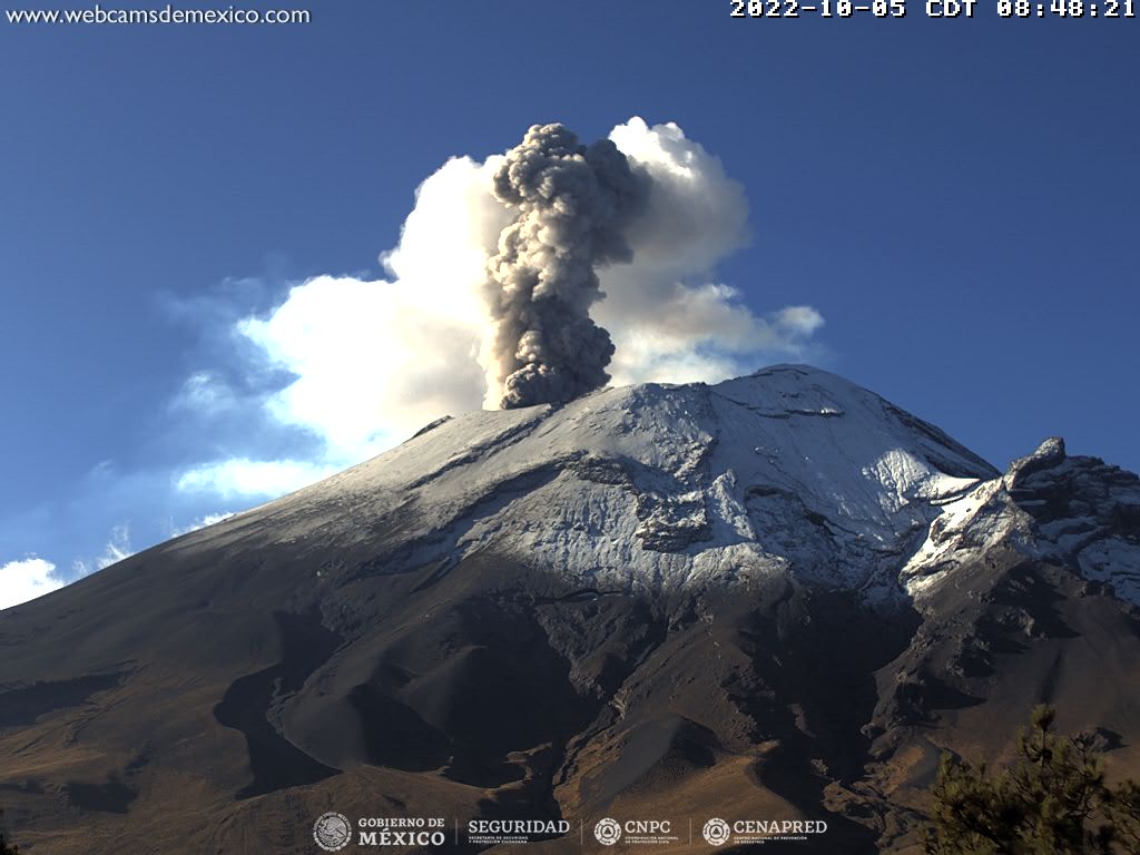
Due to cloudy conditions in the region, there is no continuous visibility towards the volcano, however some emissions have been observed to disperse to the southwest.
CENAPRED urges NOT TO APPROACH the volcano and especially the crater, because of the danger of falling ballistic fragments and, in case of heavy rains, to stay away from the bottom of the ravines because of the danger of mudslides and of debris.
The Popocatépetl volcanic alert traffic light is in YELLOW PHASE 2.
Source et photo : Cenapred.