October 08 , 2022.
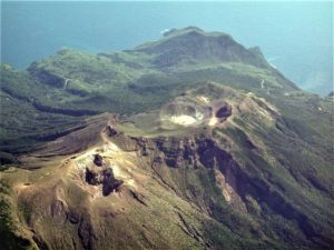
Philippines , Bulusan :
BULUSAN VOLCANO ADVISORY , 7 October 2022 , 03:00 P.M.
This is a notice of an increase in activity of Bulusan Volcano. A total of twenty-nine (29) volcanic earthquakes were recorded since 5AM of 6 October 2022 by the Bulusan Volcano Network or BVN. Ground deformation data from continuous GPS measurements and radial tilt indicate a short-term inflation of the general southern edifice of Bulusan Volcano since April 2022. Furthermore, 279 tonnes per day of sulfur dioxide (SO2) emission was measured last 29 September 2022. And weak to moderate emission of white steam-laden plumes could be observed at the crater while very weak emission of the white-steam laden plumes could be observed at northwest vents. The increased seismic activity and short-term ground deformation are likely caused by shallow hydrothermal processes beneath the edifice.
Alert Level 0 (Normal) is maintained over Bulusan Volcano but is subject to change should current activity persist. Since hydrothermal processes are underway beneath the volcano, there are increased chances of steam-driven or phreatic eruptions from its active vents. Local government units and the public are reminded that entry into the 4-kilometer radius Permanent Danger Zone (PDZ) should be prohibited. Civil aviation authorities must also advise pilots to avoid flying close to the volcano’s summit as ash from any sudden phreatic eruption can be hazardous to aircraft. Furthermore, people living within valleys and along river/stream channels especially on the southeast, southwest and northwest sector of the edifice should be vigilant against sediment-laden stream flows and lahars in the event of heavy and prolonged rainfall. DOSTPHIVOLCS is closely monitoring Bulusan Volcano’s condition and any new development will be communicated to all concerned stakeholders.
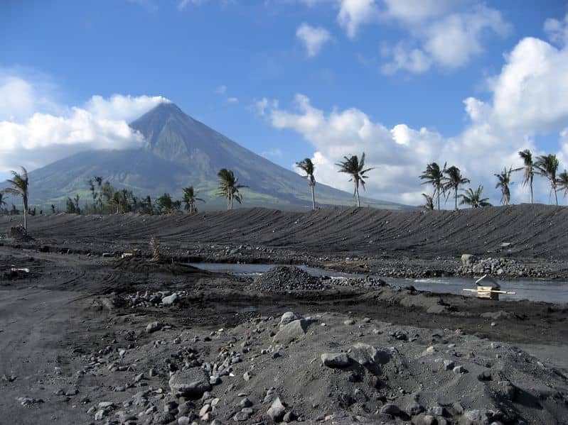
Source et photo : DOST PHIVOLCS
Philippines , Mayon :
MAYON VOLCANO BULLETIN, 7 October 2022 , 3:00 PM.
This serves as a notice of alert level raise from Alert Level 1 to Alert Level 2 of Mayon Volcano.
Since the Alert Level status of Mayon Volcano was raised from Alert Level 0 to Alert Level 1 on 21 August 2022, monitored parameters have been generally unremarkable. However, daily visual and camera monitoring of the summit crater revealed a continued aseismic growth of its lava dome. As of 4 October 2022, the lava dome has increased in volume by approximately 48,000m3 since 20 August 2022. Ocular inspection of the summit during an aerial survey this morning confirmed the presence of freshly extruded lava at the base of the summit lava dome. The event was signalled only by observations of thin remobilized light-colored ash, likely derived from lava fragmentation during the extrusion process, on the floor of the Miisi Gully since 2 October 2022. In contrast, short-term ground deformation data relative to August 2022 yielded short-term deflation on the eastern to southeastern Mayon edifice, and only slight, short-term inflation on the general western to southwestern flanks. Longer-term ground deformation parameters based on EDM, Precise Leveling, continuous GPS, and electronic tilt monitoring show that Mayon has been slightly inflated, especially on the northwest and southeast, since 2020. Lastly, SO2 emission last measured by campaign Flyspec on 1 October 2022 averaged 391 t/d, below baseline levels.
In view thereof, DOST-PHIVOLCS is raising the Alert Level of Mayon Volcano from Alert Level 1 (abnormal) to Alert Level 2 (increasing unrest). This means that there is current unrest driven by shallow magmatic processes that could eventually lead to phreatic eruptions or even precede hazardous magmatic eruption. The public is strongly advised to be vigilant and desist from entering the six (6) kilometer-radius Permanent Danger Zone (PDZ) to minimize risks from sudden explosions, rockfall and landslides. In case of ash fall events that may affect communities downwind of Mayon’s crater, people should cover their nose and mouth with damp, clean cloth or dust mask. Civil aviation authorities must also advise pilots to avoid flying close to the volcano’s summit as ash from any sudden eruption can be hazardous to aircraft. DOST-PHIVOLCS maintains close monitoring of Mayon Volcano and any new development will be communicated to all concerned stakeholders.
MAYON VOLCANO BULLETIN 08 October 2022 8:00 AM
In the past 24-hour period, the Mayon Volcano Network did not detect any volcanic earthquake. Moderate emission of white steam-laden plumes that crept downslope before drifting to the west-southwest and west was observed. Sulfur dioxide (SO2) emission was last measured at an average of 391 tonnes/day on 01 October 2022. Based on ground deformation parameters from EDM, Precise Leveling, electronic tilt, and continuous GPS monitoring, Mayon Volcano has been slightly inflated since 2020.
Source et photo : DOST-PHIVOLCS
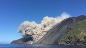
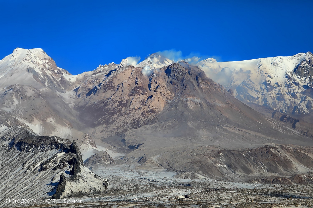
Kamchatka , Sheveluch :
VOLCANO OBSERVATORY NOTICE FOR AVIATION (VONA)
Issued: October 08 , 2022
Volcano: Sheveluch (CAVW #300270)
Current aviation colour code: ORANGE
Previous aviation colour code: orange
Source: KVERT
Notice Number: 2022-128
Volcano Location: N 56 deg 38 min E 161 deg 18 min
Area: Kamchatka, Russia
Summit Elevation: 3283 m (10768.24 ft), the dome elevation ~2500 m (8200 ft)
Volcanic Activity Summary:
A strong wind lifts ash from the southern slopes of Sheveluch volcano, a plume of resuspended ash extends 105 km to the east of the volcano. A growth of the lava dome continues, a strong fumarolic activity, and an incandescence of the lava dome, explosions, and hot avalanches accompanies this process.
The extrusive eruption of the volcano continues. Ash explosions up to 10-15 km (32,800-49,200 ft) a.s.l. could occur at any time. Ongoing activity could affect international and low-flying aircraft.
Volcanic cloud height:
2700-3000 m (8856-9840 ft) AMSL Time and method of ash plume/cloud height determination: 20221008/0020Z – Video data
Other volcanic cloud information:
Distance of ash plume/cloud of the volcano: 105 km (65 mi)
Direction of drift of ash plume/cloud of the volcano: ESE / azimuth 107 deg
Time and method of ash plume/cloud determination: 20221007/2350Z – Himawari-8 14m15
Source : Kvert.
Photo : Yu. Demyanchuk, IVS FEB RAS, KVERT.
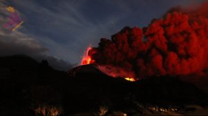
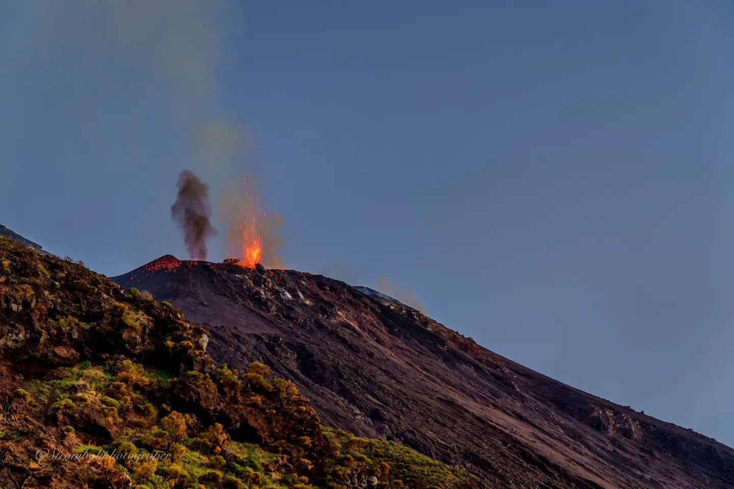
Italy , Stromboli :
Press release on STROMBOLI activity, October 08, 2022, 02:08 (00:08 UTC).
The National Institute of Geophysics and Volcanology, Osservatorio Etneo, announces that the monitoring networks recorded at 01:24 (23:24 UTC), from 22:18 UTC a new overflow of lava from the North crater is observed which is overlaps with the previous ones. This overflow is currently confined to the upper part of the Sciara del Fuoco. From the seismic point of view, the amplitude of the volcanic tremor is at medium-low levels. The signals from the GNSS deformation and tilt networks do not show significant variations.
Further updates will be communicated soon.
Source : INGV.
Photo : Stromboli Stati d’animo.
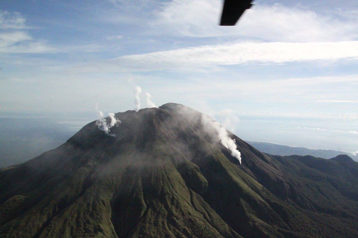
Indonesia , Merapi :
Report on the activity of Mount Merapi from September 30, 2022 to October 06, 2022, Published on October 07, 2022
RESULTS OF OBSERVATIONS
Visual
The weather around Mount Merapi is usually sunny in the morning and afternoon, while the evening is foggy. White smoke, thin to medium thickness, low pressure and 350 m high was observed from the Mount Merapi observation post of Babadan on October 03, 2022 at 06:30 WIB.
This week, 5 lava avalanches were observed in the southwest, descending the Bebeng river with a maximum slip distance of 1800 m and one towards the west, upstream of the Kali Putih river with a maximum slip distance of 800 m.
On the southwest and central dome still growing, but no significant morphological changes are observed.. Based on photo analysis, the volume of the dome is calculated at 1,626,000 m3, and for the central dome, it is 2,772,000 m3.

Seismicity
This week, the seismicity of Mount Merapi showed:
273 deep volcanic earthquakes (VTA),
2 shallow volcanic earthquakes (VTB),
260 multi-phase earthquakes (MP),
456 avalanche earthquakes (RF),
64 emission earthquakes (DG),
3 tectonic earthquakes (TT).
The intensity of this week’s seismicity is still quite high.
Deformation
The deformation of Mount Merapi that was monitored using EDM and GPS this week shows no significant changes.
Rain and lahars:
This week, there was rain at the Kaliurang observation post with a rain intensity of 88 mm/h for 145 minutes on October 03, 2022. An increase in the flow of the Boyong River was reported.
Conclusion
Based on the results of visual and instrumental observations, it is concluded that:
The volcanic activity of Mount Merapi is still quite high in the form of effusive eruption activity. The state of the activity is defined at the « SIAGA » level.
Source et photo : BPPTKG.