October 06 , 2022.
La Réunion , Piton de la Fournaise :
Press release, Paris Institute of Earth Physics, Piton de la Fournaise Volcanological Observatory, October 05, 2022 – 8:30 a.m. (local time) – 4:30 a.m. (UTC time).
Ongoing eruption
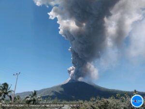
The eruption started on 09/19/2022 around 07:48 local time continues. During the last 24 hours, the amplitude of the eruptive tremor (indicator of an emission of lava and gas on the surface) fluctuates with phases of increase and decrease on the scale of a few hours (Figure 1). On the seismic recordings close to the eruptive site, there is also an increase in the high frequencies of the tremor, suggesting a potential structural instability of the eruptive site.
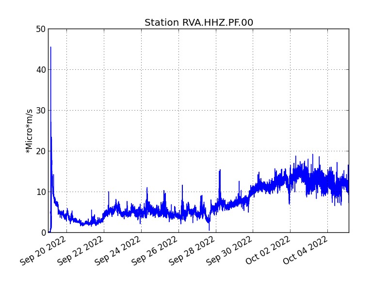
Evolution of the RSAM (indicator of an emission of lava and gas on the surface) since 09/19/2022 00:00 UTC time (04:00 local time) on the RVA seismological station located at the level of the Rivals crater (© OVPF / IPGP).
The seismicity under the summit remains significant; during the day of October 4, 65 volcano-tectonic earthquakes were recorded directly above the summit area. The events of higher magnitudes are located under the eastern edge of the Dolomieu crater and have negative polarities indicating collapses at the level of the reservoir roof.
At the same time, data from the permanent GPS stations of the OVPF-IPGP show signals associated with a deflation (deflation) of the building of the order of 2 cm in 4 days.
This seismicity and this deflation suggest a depressurization of the magmatic reservoir.
Strong degassing is observed at the level of the eruptive vents and the lava field with a plume of gas covering the entire western sector of the volcano up to the Plaine des Sables (Figure 2). All these parameters (unstable tremor, strong seismicity, deflation and strong degassing) raise fears of destabilization at the level of the eruptive site as well as a paroxysm (as was observed for example during the April 2020 eruption).
This is why the OVPF-IPGP teams decided this morning to cancel their field mission scheduled for today on the eruptive site.
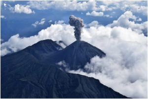
Images from the OVPF-IPGP webcam located at Piton de Bert show:
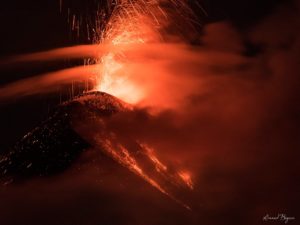
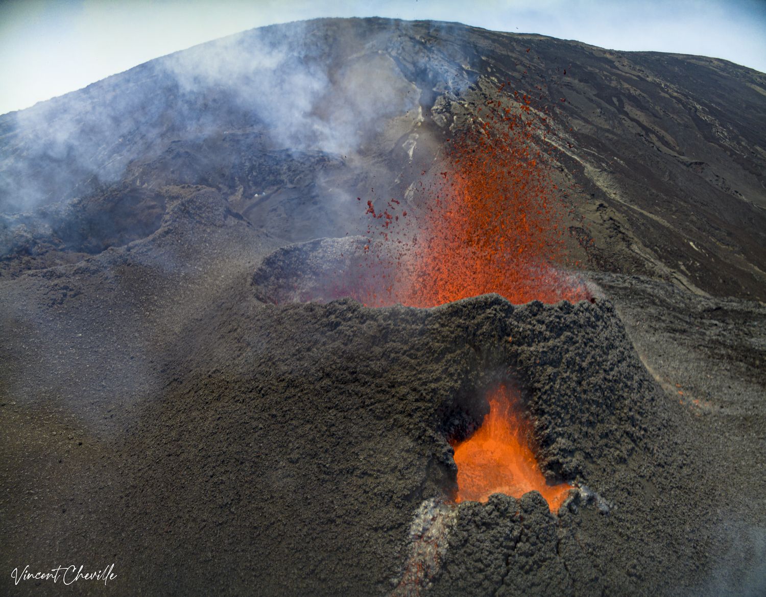
– a lava projection activity still present at the level of the main eruptive mouth;
– the secondary vent, located on the southern flank of the cone, no longer seems active (Figure 3);
– significant degassing that persists at the eruptive site (Figures 2 and 3);
– the majority of lava flows are still through lava tunnels within which many resurgences are visible up to several kilometers from the eruptive cone.
As of October 3, 2022, the size of the eruptive cone being formed was 39 m high and 140 m wide at its base. The eruptive mouth from which the lava projections escape at its summit was 75 m wide.
Lava flow estimates established by satellite method on the HOTVOLC (OPGC – Clermont Auvergne University) and MIROVA (University of Turin) platforms indicate an average flow of 10 m3 /s (fluctuation between 7 and 25 m3 /s). As lava flow activity is now partly tunnelled, these estimates are minimum values.
Alert level: Alert 2-1 (Access to the Enclos prohibited; eruption in the Enclos without any particular threat to the safety of persons, property or the environment).
OVPF-IPGP press release – October 5, 2022 – 10:30 a.m.
Stopping of eruptive activity

No hypothesis is ruled out as to the evolution of the future situation (pause of the eruption, definitive cessation, resumption of activity on the same site, resumption of activity on another site), taking into account the strong seismicity that has been recorded in recent days.
Source : Direction OVPF / IPGP.
Photos : OVPF , Vincent Cheville / Tunnels de lave Réunion.
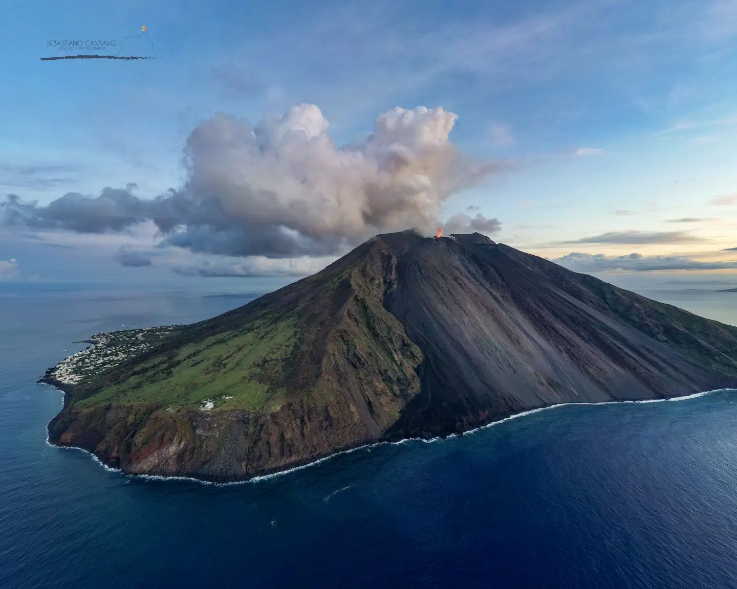
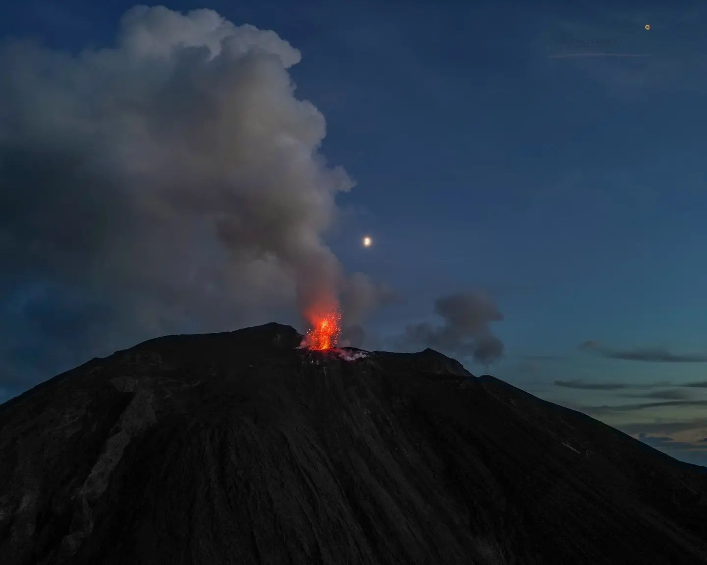
Italy , Stromboli :
WEEKLY BULLETIN, from September 26, 2022 to October 02, 2022, (issue date October 04, 2022).
ACTIVITY STATUS SUMMARY
In the light of the surveillance data, it is highlighted:
1) VOLCANOLOGICAL OBSERVATIONS: During this period, normal Strombolian-type explosive activity was observed with spattering activity and a major event from the North Crater area. The total hourly frequency oscillated on medium-low values (5-10 events/h). The intensity of the explosions was low and medium in the North crater area while it was medium in the Center-South crater area.
2) SEISMOLOGY: The seismological parameters monitored do not show any significant changes, with the exception of the occurrence, at 13:24:30 (UTC) on 09/29, of an explosion of greater than normal amplitude since the North crater area.
3) GROUND DEFORMATIONS: Ground deformation monitoring networks have not detected any significant variations.
4) GEOCHEMISTRY: SO2 flux at an average level
The flux of CO2 from the soils of the summit zone after an initial increase in recent days has risen to medium-high values.
The C/S ratio in the plume emerges on average values (C/S = 3.8).
Isotope ratio of dissolved Helium in heat sinks: there is no update since the sampling of September 07, 2022.
5) SATELLITE OBSERVATIONS: The thermal activity observed by satellite in the summit area was weak.
VOLCANOLOGICAL OBSERVATIONS
In the period under observation, the eruptive activity of Stromboli was characterized by the analysis of the images recorded by the surveillance cameras of the INGV-OE at an altitude of 190m (SCT-SCV) which were restored on September 21 2022 and Punta dei Corvi, while the other cameras at altitude 400m and Pizzo, following problems in the acquisition of video signals caused by damage to the optical fiber connecting Punta Labronzo and COA due to bad weather, which have hit the island on August 12, 2022, are currently unavailable. The explosive activity was mainly produced by 3 (three) eruptive vents located in the North crater area and by at least 2 (two) eruptive vents located in the Center-South crater area. All vents are located within the depression that occupies the crater terrace.
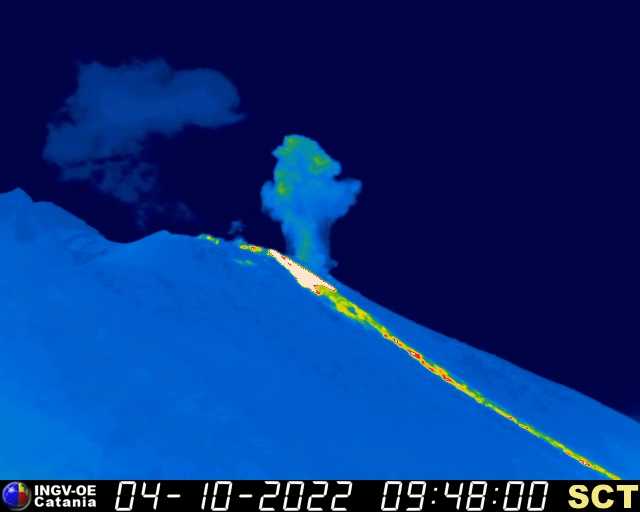
On September 29, 2022, a major explosive event was observed from the North Crater area.
Major explosive event of September 29, 2022.
On September 29 from 13:24:55 UTC a major explosive event occurred in the N2 sector of the N crater zone. The first, most energetic pulse lasts about 8
seconds. It produced a plume of fine materials (ash), which reached 300 m in height above the craters, mixed with coarse materials (shreds of lava, bombs and lapilli) which fell in abundance along the Sciara del Fuoco. The first pulse, still in the N2 sector, was followed by at least 4 low-intensity explosive events (less than 100 m in height) of coarse materials. The total duration of the event was approximately 1 minute.

Images of the major event of September 29, 2022 taken by the infrared camera at altitude 190 (SCT).
d) Images of the major event of September 29, 2022 taken by the Punta dei Corvi infrared camera (SPCT).
Observations of explosive activity captured by surveillance cameras
Sector N1 located in the area of the North crater produced explosions of low intensity (less than 80 m high) to medium (less than 150 m high) emitting coarse materials (bombs and lapilli). Sector N2, with two emission points, showed continuous intense spattering activity from the September 29 event until September 30. The explosions were of low intensity emitting coarse material. The average frequency of explosions varied from 3 to 5 events/h.
In the Center-South zone, it was not possible to discriminate between the different sectors due to the close framing of the cameras at an altitude of 190m towards the zone of the Center-South crater. In this crater area, with at least two emission points, explosions of mainly medium intensity (less than 150 m) emitting coarse materials sometimes mixed with fines (ash) were observed. The frequency of the explosions varied between 1 and 5 events/h.
PRESS RELEASE ON STROMBOLI ACTIVITY, October 03, 2022, 12:26 (10:26 UTC),
The National Institute of Geophysics and Volcanology, Osservatorio Etneo, announces that the monitoring networks recorded at 11:15 (09:15 UTC), the beginning of an overflow of lava from the North Crater, this overflow caused rolling of lava material along the Sciara del Fuoco, the poorly fed lava front remains at the base of the northeast crater.
From the seismic point of view, there is no significant variation in the amplitude of the volcanic tremor.
There are currently no significant changes in the ground deformations measured by the GNSS network.
PRESS RELEASE ON STROMBOLI ACTIVITY, October 04, 2022, 10:11 (08:11 UTC),
The National Institute of Geophysics and Volcanology, Osservatorio Etneo, reports that according to observations from surveillance cameras, the lava flow described in the previous press release is poorly fed. Explosive activity continues in both sectors (North and Center-South). From the seismic point of view, there are no significant variations in the amplitude of the volcanic tremor. Signals from GNSS and Tilt stations show no significant changes.
PRESS RELEASE ON STROMBOLI ACTIVITY, 04 October 2022, 11:43 (09:43 UTC),
The National Institute of Geophysics and Volcanology, Osservatorio Etneo, announces that from 09:07 UTC a new overflow of lava is observed from the North crater which overlaps the previous one. This overflow caused the lava material to roll along the Sciara del Fuoco and the front of the flow currently remains confined to the upper part of it.
In addition, a slight increase in the frequency of explosive activity and splashing is observed. From the seismic point of view, there is no significant variation in the amplitude of the volcanic tremor. The signals from the GNSS network do not show any significant variations. Tilt signals from Timpone Del Fuoco station over the past few hours show a slight change in trend.
October 05, 2022, 13:00 (11:00 UTC): Monitoring networks recorded the return of metrics to normal activity at 12:59 p.m. (10:59 UTC).
Source : INGV.
Photos : Stromboli stati d’animo / Sebastiano Cannavo , INGV ,
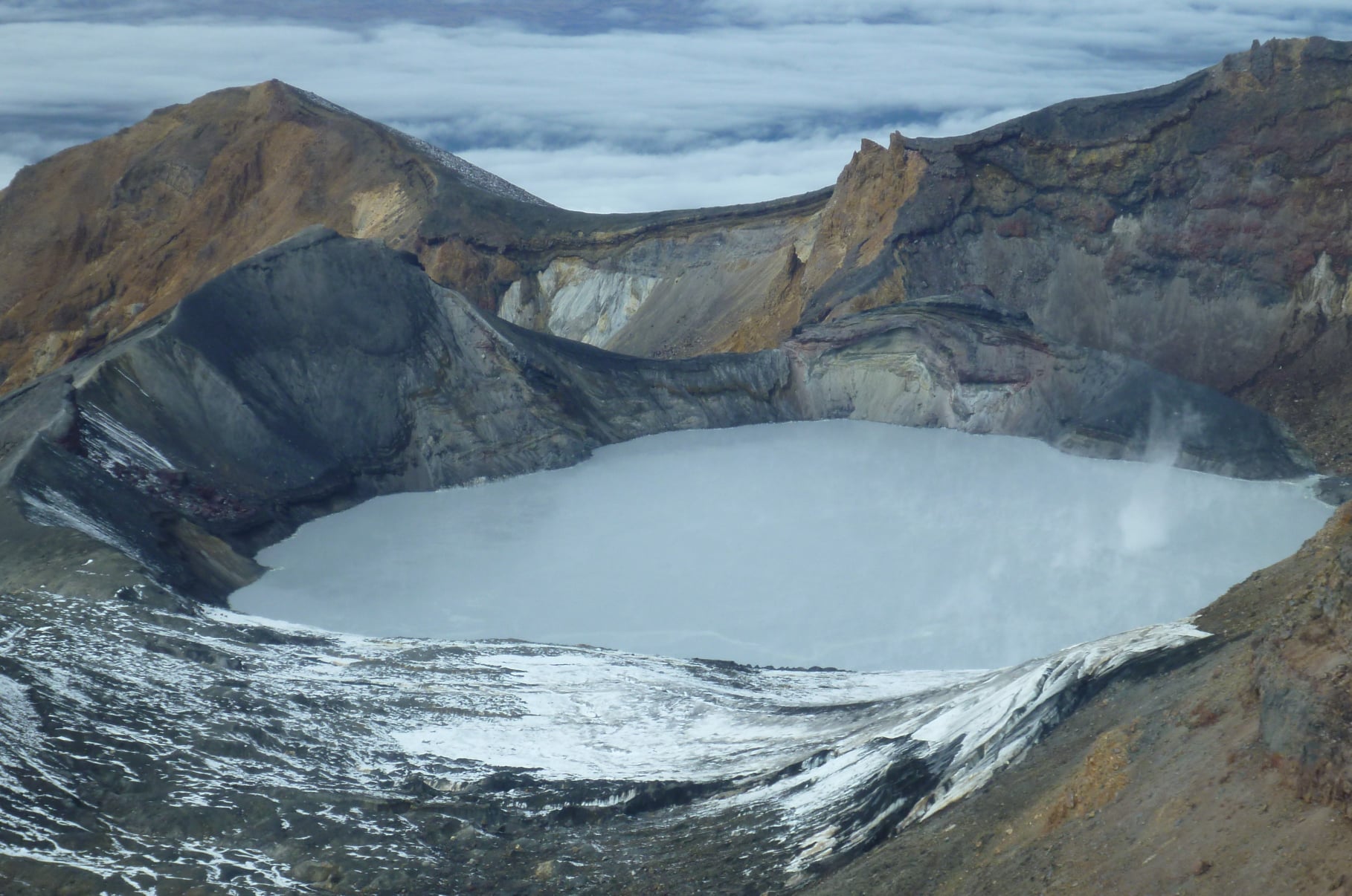
New Zealand , Ruapehu :
Volcanic unrest remains low at Mt Ruapehu. The Volcanic Alert Level remains at Level 1.
Observational data for Mt Ruapehu indicates the level of volcanic unrest activity remains low. Volcanic tremor levels are at typical background levels, lake chemistry and gas data show no changes, and the lake temperature remains warm. The Volcanic Alert Level remains at Level 1 and the Aviation Colour Code remains Green.
Over the last 3 months, the level of volcanic tremor has remained weak at Mt. Ruapehu, representing typical background levels. During the same period, the Crater Lake (Te Wai ā-moe) temperature has decreased from around 26 °C in early July to fluctuate between 21 and 25 °C in August and September. Currently the lake temperature is 23 °C. This is consistent with heat flow into the lake of about 150-200 MW.
Available analyses of water samples from Crater Lake (Te Wai ā-moe) have shown no changes in the lake chemistry. This indicates that there has been no evidence of chemical interaction between magma (new molten rock) and the hydrothermal system controlling the composition, level, and temperature of the Crater Lake.
In summary, all monitoring indicators remain at background levels and the potential for eruptive activity is generally decreasing. However, because magma moved to higher levels in the volcano earlier this year and is still present inside the volcano, uncertainty remains around its potential impact on future activity. As a result, whilst declining, the likelihood of an eruption at Mt Ruapehu over the next 3 months still remains higher than it was at VAL 1 in early 2022.
The most likely outcome of the ongoing unrest is no eruption, or minor eruptive activity confined to the lake basin. If this did occur, it could possibly generate lahars (volcanic mudflows) in the Whangaehu River.
The low levels of volcanic tremor, the Crater Lake chemistry data, and a stable Crater Lake temperature are consistent with a low level of volcanic unrest at Mt Ruapehu and therefore the Volcanic Alert Level remains at Level 1. The Aviation Colour Code remains Green.
Mt Ruapehu is an active volcano and has the potential to erupt with little or no warning when in a state of minor volcanic unrest.
Source et photo : Geonet /Brad Scott / , Duty Volcanologist
.
Hawaii , Mauna Loa :
19°28’30 » N 155°36’29 » W,
Summit Elevation 13681 ft (4170 m)
Current Volcano Alert Level: ADVISORY
Current Aviation Color Code: YELLOW
Mauna Loa is not erupting and there are no signs of an imminent eruption at this time.
However, Mauna Loa is currently experiencing heightened unrest. Earthquake activity has been increasing from 5-10 earthquakes per day since June 2022, to 10-20 earthquakes per day in July and August, and reaching approximately 40-50 earthquakes per day over the past two weeks. Peak numbers of over 100 earthquakes per day occurred on September 23rd and 29th.
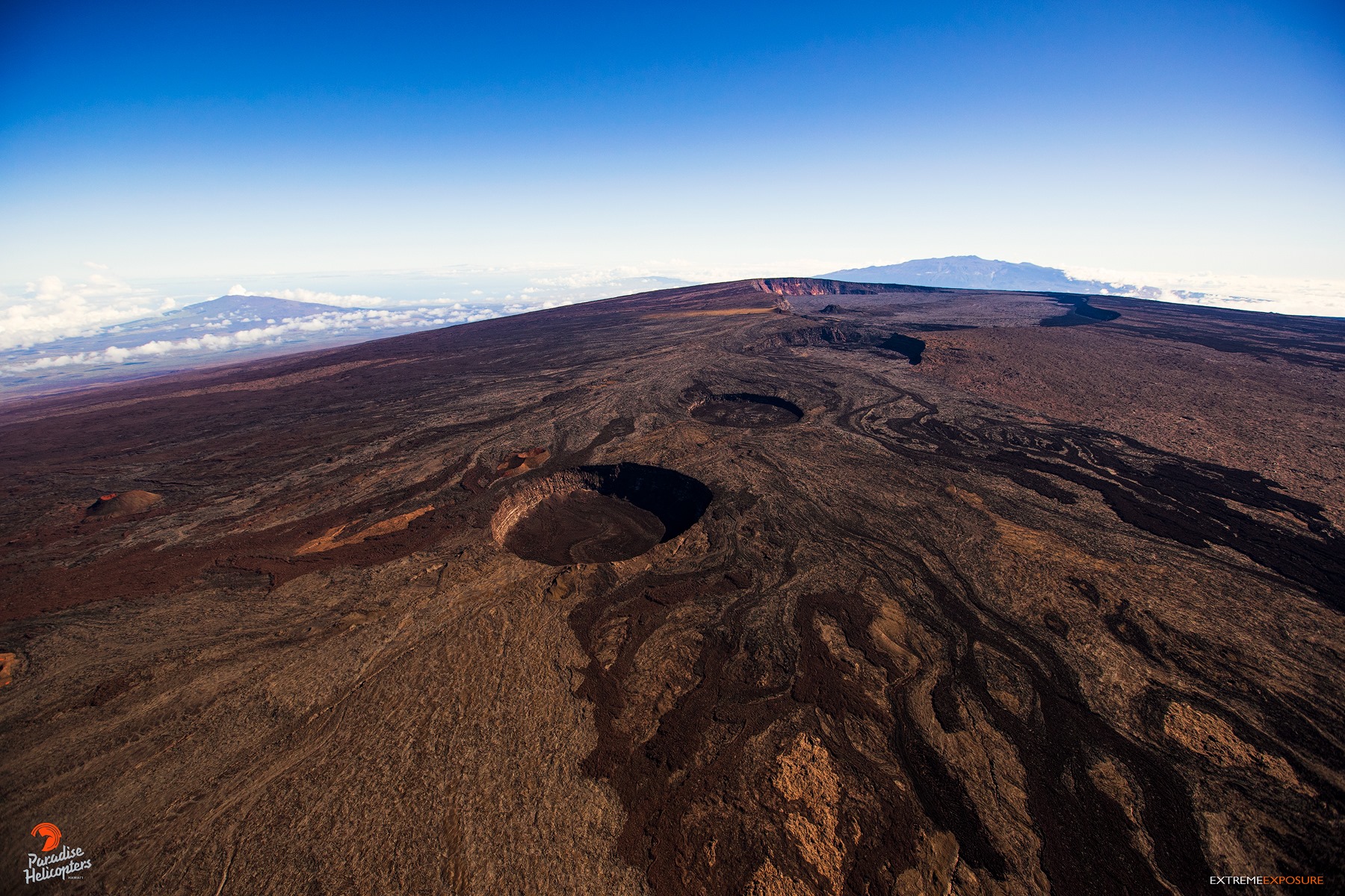
Inflation or expansion of Mauna Loa’s summit is accompanying the earthquake activity and has also increased in the past two weeks. The last time Mauna Loa displayed similar elevated earthquake activity and expansion of the summit region was late-January to late-March of 2021. Additional periods of increased earthquake activity have also occurred during the 38 years since the last eruption of Mauna Loa in 1984.
The Alert Level for Mauna Loa remains at ADVISORY/YELLOW.
Beginning tomorrow, October 6, HVO will be changing UPDATES for Mauna Loa from WEEKLY to DAILY, reflecting the heightened level of unrest.
HVO is continuing to monitor conditions carefully and will issue appropriate updates if conditions change.
Source : HVO
Photo : Bruce Omori.
Comoros , Karthala :
According to the Direction Générale de la Sécurité Civile (DGSC) – Comores on 4 October, the Observatoire Volcanologique du Karthala (OVK) reported that activity at Karthala had significantly declined during the previous few days. OVK recommended that the Alert Level remain at Yellow (the second lowest level on a four-level scale).
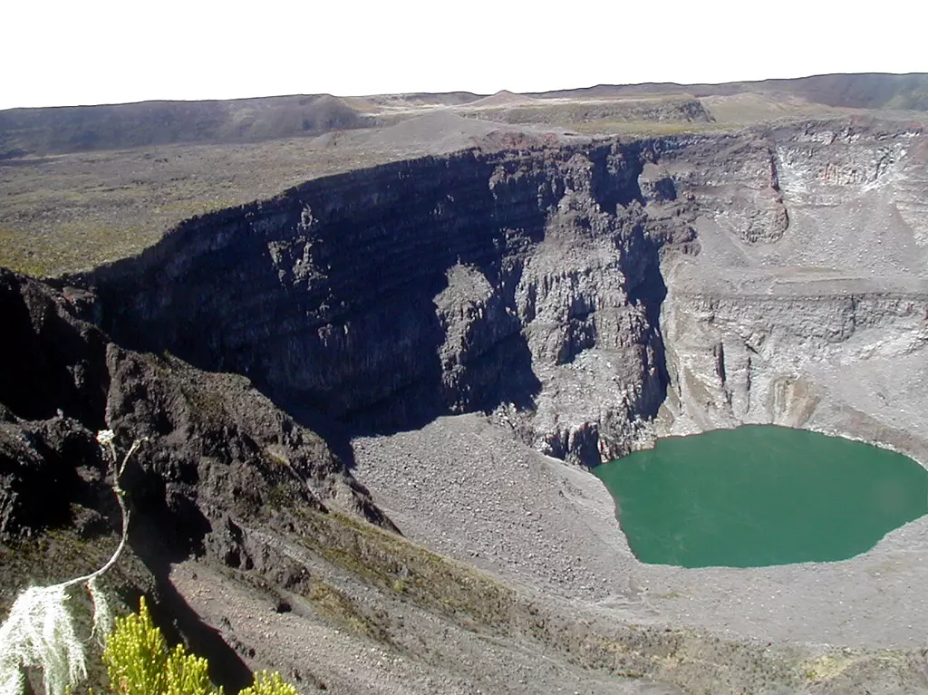
The southernmost and largest of the two shield volcanoes forming Grand Comore Island (also known as Ngazidja Island), Karthala contains a 3 x 4 km summit caldera generated by repeated collapse. Elongated rift zones extend to the NNW and SE from the summit of the Hawaiian-style basaltic shield, which has an asymmetrical profile that is steeper to the S. The lower SE rift zone forms the Massif du Badjini, a peninsula at the SE tip of the island. Historical eruptions have modified the morphology of the compound, irregular summit caldera. More than twenty eruptions have been recorded since the 19th century from the summit caldera and vents on the N and S flanks. Many lava flows have reached the sea on both sides of the island. An 1860 lava flow from the summit caldera traveled ~13 km to the NW, reaching the W coast to the N of the capital city of Moroni.
Source : GVP , OVK
Photo : Nicolas-Villenueve-Universite-de-La-Reunion-