September 22 , 2022.
La Réunion , Piton de la Fournaise :
Press release, Paris Institute of Earth Physics, Piton de la Fournaise Volcanological Observatory, September 21, 2022 – 1:30 p.m. (local time) – 9:30 a.m. (UTC time)
Ongoing eruption
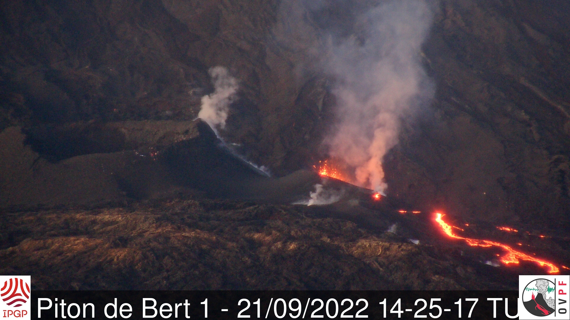
The eruption started on 09/19/2022 around 07:48 local time continues. Following the decrease in activity in the lava fountain and the focus of the activity on the lowest part of the cracks opened at the start of the eruption, the amplitude of the eruptive tremor (indicator of an emission of lava on the surface ) continued its slow decrease throughout the day yesterday, and has stabilized since midnight (UTC time, 00h time) at about 10% of its initial amplitude.

Evolution of the RSAM (indicator of a surface lava emission) since 09/19/2022 00:00 UTC time (04:00 local time) on the RVA seismological station located at the Rivals crater (© OVPF/IPGP)
The seismicity under the summit zone has now disappeared (no volcano-tectonic earthquake recorded over the last 24 hours).
Despite some clearings at the end of the morning:
– No lava flow estimate could be established by satellite method on the HOTVOLC platform (OPGC – Clermont Auvergne University), probably due to unfavorable cloud cover.
– the images from the OVPF-IPGP webcams showed a very marked decrease in activity focused on the lowest part of the crack system which opened on Monday.
The OVPF-IPGP NOVAC station located on the western rampart of the Enclosure detected the gas plume linked to the eruption with SO2 fluxes close to or even slightly higher than those of the last eruption (December 22, 2021- January 17, 2022) with a maximum peak estimated at 8000 tonnes per day (8 kton) at the start of the eruption. Over the last 24 hours, the peak flow of SO2 measured on the same site was only 2300 tons.
Due to the very bad weather conditions on site:
– no on-site reconnaissance could be carried out by the OVPF-IPGP teams, whether on foot or by air today.
Alert level: Alert 2-1 (eruption in the Enclos without any particular threat to the safety of people, property or the environment)
Source et photos :direction de l’OVPF-IPGP.
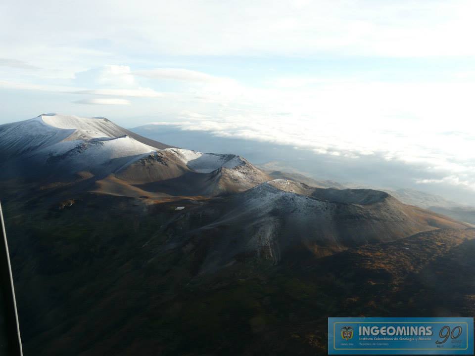
Colombia , Purace – Chaîne volcanique Los Coconucos :
Weekly bulletin of the activity of the Puracé volcano – Los Coconucos volcanic chain
Volcano activity level continues at Yellow or (III) Activity Level: changes in behavior of volcanic activity.
From the analysis and evaluation of the information obtained through the monitoring network of the Puracé volcano – Los Coconucos volcanic chain, during the week of September 13 to 19, 2022, the COLOMBIAN GEOLOGICAL SERVICE – Volcanological and Seismological Observatory of Popayan reports that:
-Seismic activity related to rock fracturing showed a slight increase in the number of events compared to previous weeks. The occurrence of a seismic swarm (high occurrence of seismic events over a short period of time) during September 15 is mainly apparent, this seismicity was located 1.5 km southwest of the crater of the Puracé volcano in a depth range between 3 and 4 km, with a maximum magnitude of 1.3 ML. Regarding the total number of events recorded during the evaluated period, there were 904 seismic events, of which 296 were associated with rock fracturing processes (type VT) and 608 with fluid dynamics in the volcanic conduits; of these, 538 were classified as long-period events (LP type), five (5) were associated with both fracture mechanisms and fluid dynamics, so they were classified as hybrid (HB type) , 11 were classified as « Tornillos » type earthquakes (TO type) and 54 as low energy input tremor pulses (TR type).
The geodetic network of GNSS (Global Navigation Satellite System) stations monitoring ground deformation continues to record a process related to inflation.
By monitoring the surface activity, the images obtained during the week thanks to the web cameras Anambío, Mina, Lavas Rojas, Cerro Sombrero and Curiquinga showed degassing of the volcanic system, with a white column oriented preferentially towards the North-West. .
Regarding the monitoring of volcanic gases, the sulfur dioxide (SO2) flux emissions recorded by the telemetry stations continue to show flux variations, with a maximum emitted of 2021 t / day for the week evaluated. The other instruments for measuring carbon dioxide (CO2) and radon gas (222Rn) in the volcanic influence zone record considerable variations in their concentrations for the period evaluated, which is normal in active volcanic systems.
Magnetic field and infrasound wave monitoring sensors did not record variations associated with changes in volcanic activity.
Source : SGC.
Photo : Ingeominas
Kamchatka , Sheveluch :
VOLCANO OBSERVATORY NOTICE FOR AVIATION (VONA)
Issued: September 21 , 2022
Volcano: Sheveluch (CAVW #300270)
Current aviation colour code: ORANGE
Previous aviation colour code: orange
Source: KVERT
Notice Number: 2022-118
Volcano Location: N 56 deg 38 min E 161 deg 18 min
Area: Kamchatka, Russia
Summit Elevation: 3283 m (10768.24 ft), the dome elevation ~2500 m (8200 ft)

Volcanic Activity Summary:
A strong wind lifts ash from the southern slopes of Sheveluch volcano, a plume of resuspended ash extends 332 km to the east of the volcano. A growth of the lava dome continues, a strong fumarolic activity, and an incandescence of the lava dome, explosions, and hot avalanches accompanies this process.
The extrusive eruption of the volcano continues. Ash explosions up to 10-15 km (32,800-49,200 ft) a.s.l. could occur at any time. Ongoing activity could affect international and low-flying aircraft.
Volcanic cloud height:
2500-3000 m (8200-9840 ft) AMSL Time and method of ash plume/cloud height determination: 20220921/2250Z – Video data
Other volcanic cloud information:
Distance of ash plume/cloud of the volcano: 332 km (206 mi)
Direction of drift of ash plume/cloud of the volcano: E / azimuth 90 deg
Time and method of ash plume/cloud determination: 20220921/2150Z – Himawari-8 14m15
Source : Kvert
Photo : Yu. Demyanchuk, IVS FEB RAS, KVERT.
Tonga Islands , Home Reef :
The Tonga Geological Services reported that the new island at Home Reef that emerged from the ocean on 10 September continued to grow through 20 September. The eruption continued at variable intensities, producing daily plumes of gas and steam that rose no higher than 1 km above sea level.
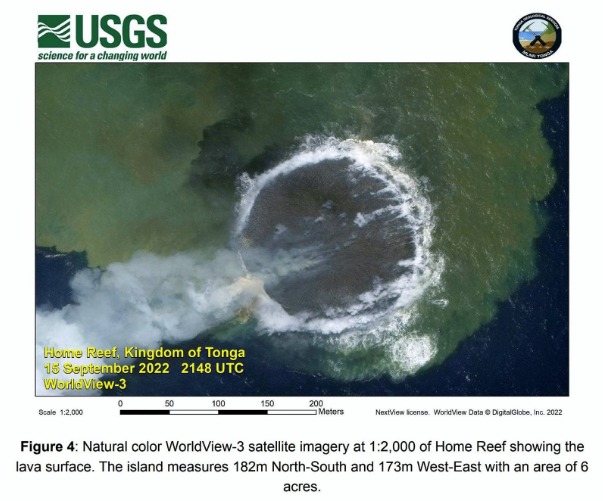
The island was surrounded by plumes of discolored water. The island was 170 m in diameter by 16 September and had grown to 182 m N-S and 173 m E-W by 18 September. Steam plumes with some ash content rose 3 km during 19-20 September. Mariners were advised to stay 4 km away from the volcano.
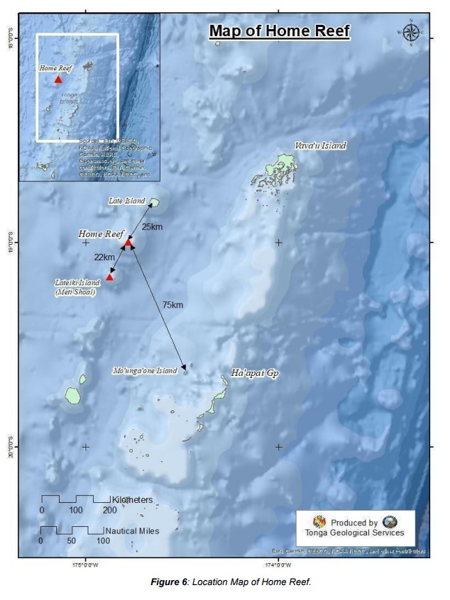
Home Reef, a submarine volcano midway between Metis Shoal and Late Island in the central Tonga islands, was first reported active in the mid-19th century, when an ephemeral island formed. An eruption in 1984 produced a 12-km-high eruption plume, copious amounts of floating pumice, and an ephemeral island 500 x 1500 m wide, with cliffs 30-50 m high that enclosed a water-filled crater. Another island-forming eruption in 2006 produced widespread dacitic pumice rafts that reached as far as Australia.
Sources : GVP , Tonga Geological Services, Government of Tonga.
Japan , Suwanosejima :
JMA reported that the eruption at Suwanosejima’s Ontake Crater continued during 12-19 September. A total of 11 explosions produced eruption plumes that rose as high as 1.4 km above the crater rim and ejected large blocks 600 m from the vent. Volcanic tremor was occasionally recorded. The Alert Level remained at 2 and the public was warned to stay 1 km away from the crater.
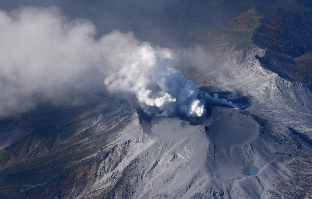
The 8-km-long island of Suwanosejima in the northern Ryukyu Islands consists of an andesitic stratovolcano with two historically active summit craters. The summit is truncated by a large breached crater extending to the sea on the east flank that was formed by edifice collapse. One of Japan’s most frequently active volcanoes, it was in a state of intermittent Strombolian activity from Otake, the NE summit crater, between 1949 and 1996, after which periods of inactivity lengthened. The largest recorded eruption took place in 1813-14, when thick scoria deposits blanketed residential areas, and the SW crater produced two lava flows that reached the western coast. At the end of the eruption the summit of Otake collapsed, forming a large debris avalanche and creating the open Sakuchi caldera, which extends to the eastern coast. The island remained uninhabited for about 70 years after the 1813-1814 eruption. Lava flows reached the eastern coast of the island in 1884. Only about 50 people live on the island.
Sources : GVP , Japan Meteorological Agency (JMA)
Photo : Masanori Genko
Hawaii , Kilauea :
19°25’16 » N 155°17’13 » W,
Summit Elevation 4091 ft (1247 m)
Current Volcano Alert Level: WATCH
Current Aviation Color Code: ORANGE
Activity Summary:
The summit eruption of Kīlauea Volcano, within Halemaʻumaʻu crater, continued over the past 24 hours. Extensive breakouts have occurred along the western and northern parts of the crater floor within this time. These breakouts coincided with a drop in the crater floor and the active part of the lava lake. All activity remains confined to the crater floor of Halemaʻumaʻu with no significant changes in areas outside of the summit.
Halemaʻumaʻu Lava Lake Observations:
Eruption of lava from the western vent into the active lava lake and onto the crater floor continued over the past 24 hours with extensive breakouts in the western and northern parts of the crater floor starting at 4:00 PM HST on September 20, 2022. The active part of the lava lake dropped by 10 meters (33 feet) and other parts of the crater floor dropped by several meters (several yards).
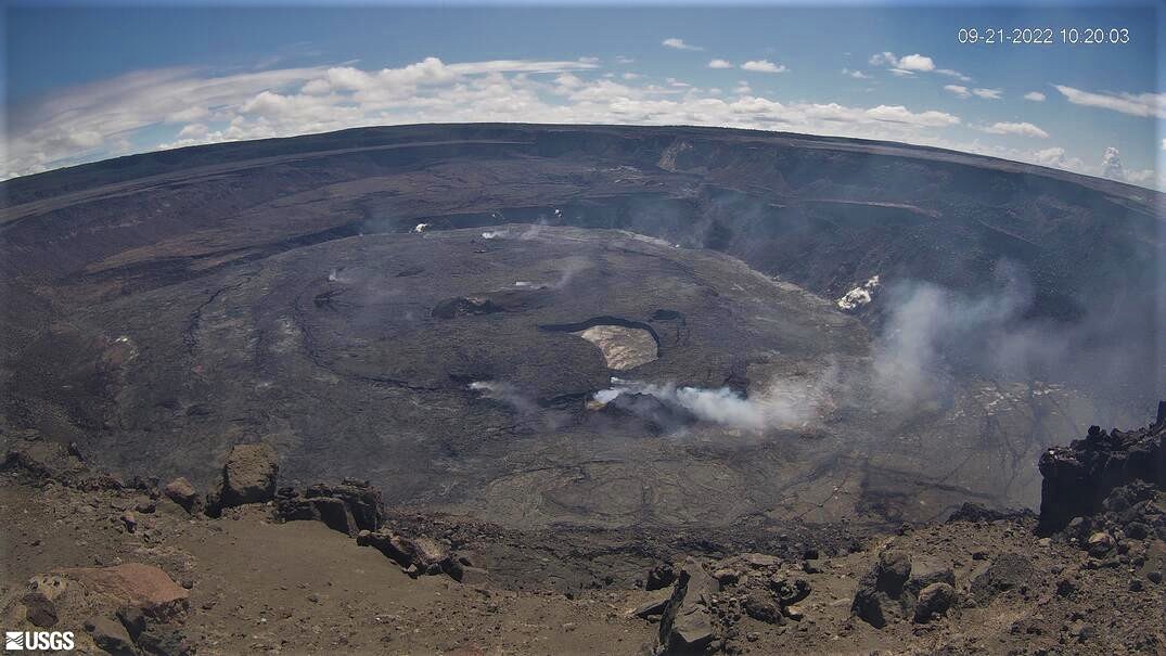
Summit Observations:
Summit tiltmeters recorded a large increase in inflationary tilt of approximately 12 microrads (at UWE) and 1.5 microrads (at SDH) from 3:00 to 4:00 PM, which has remained flat since. This was in association with a summit seismic swarm of more than 80 earthquakes from 3:00 PM to 6:00 PM. Most earthquakes in this swarm occurred approximately 1 mile (1.5 kilometers) beneath Halemaʻumaʻu. The largest recorded earthquake was a magnitude 2.9, with the majority of the earthquakes being less than magnitude 2. Volcanic tremor remains above background levels. A sulfur dioxide (SO2) emission rate of approximately 1055 tonnes per day (t/d) was measured on September 20, 2022.
Rift Zone Observations:
No unusual activity has been noted along the East Rift Zone or Southwest Rift Zone; low rates of ground deformation and seismicity continue along both. Measurements from continuous gas monitoring stations downwind of Puʻuʻōʻō in the middle East Rift Zone remain below detection limits for SO2, indicating that SO2 emissions from Puʻuʻōʻō are negligible.
Source et photo : HVO.