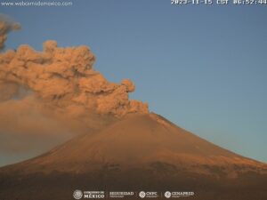
September 21 , 2022.
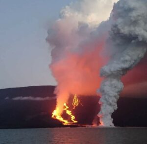
La Réunion , Piton de la Fournaise :
Press release, Piton de la Fournaise Volcanological Observatory, September 20, 2022 – 3:30 p.m. (local time) – 11:30 a.m. (UTC time)
Ongoing eruption
The eruption started on 09/19/2022 around 7:48 a.m. local time continues. With the decrease in activity in the lava fountain and the focusing of the activity, the amplitude of the eruptive tremor (indicator of an emission of lava on the surface) decreased sharply during the day yesterday, and s has stabilized since 11 p.m. yesterday evening (UTC time, 03 a.m.) at about 15% of its initial amplitude (Figure 1).

Figure 1: Evolution of the RSAM (indicator of a surface lava emission) since 09/19/2022 00:00 UTC time (04:00 local time) on the RVA seismological station located at the Rivals crater (© OVPF/IPGP)
Seismicity under the summit area is down with 24 volcano-tectonic earthquakes recorded over the past 24 hours.
Thanks to some clearing at the end of the day yesterday:
– lava flow estimates could be established by satellite method on the HOTVOLC platform (OPGC – Clermont Auvergne University), with peaks at 28 m3 / sec,
– OVPF-IPGP webcam images showed lava fountain activity focusing on the lowest part of the fissure system that opened yesterday (Figure 2).

The OVPF-IPGP NOVAC station located on the western rampart of the Enclosure detected the gas plume linked to the eruption with SO2 fluxes close to or even slightly higher than those of the last eruption (December 22, 2021- January 17, 2022) with a maximum peak estimated at 8000 tons per day (8 kton).
In parallel, the passage of the TROPOMI satellite around 10:10 a.m. (UTC time, 2:10 p.m. local time) indicated an emission of 2.054 kton of SO2 since the start of the eruption (i.e. in just under 6:30 a.m. of eruption). This estimate is calculated by integration within a radius of 200 km around the volcano. The satellite image also indicated a dispersion of the gas plume in the direction of the
South West .
Due to the very bad weather conditions on site:
– no on-site reconnaissance could be carried out by the OVPF-IPGP teams, whether on foot or by air.
Alert level: Alert 2-1 (eruption in the Enclos without any particular threat to the safety of people, property or the environment)
Source : direction de l’OVPF-IPGP.
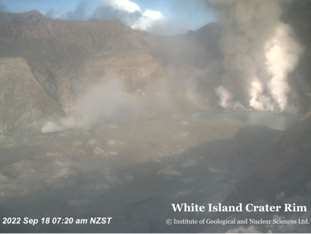
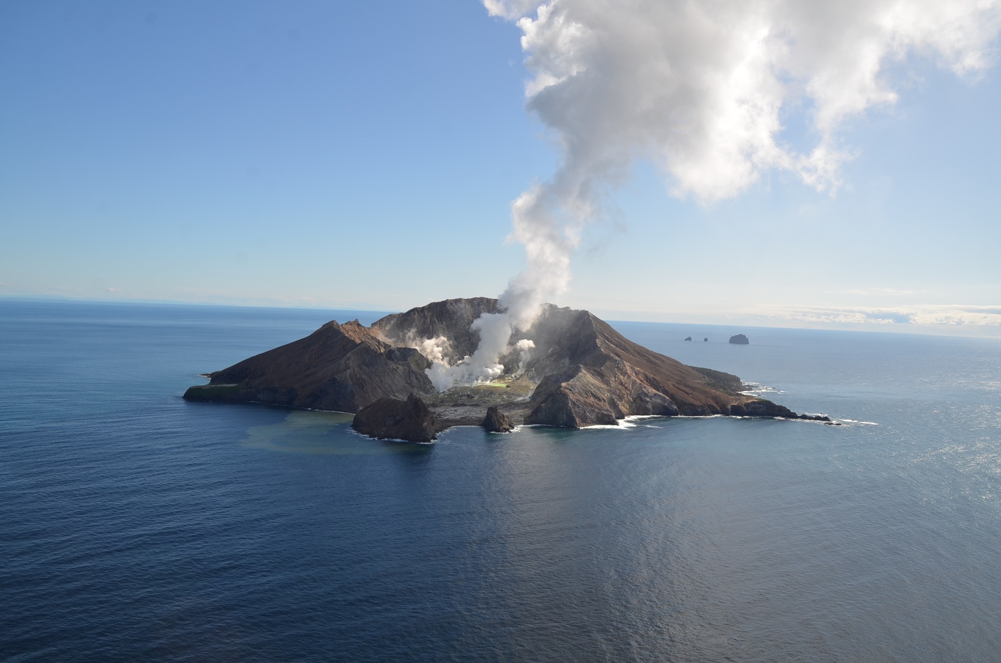
New Zealand , White Island :
Web camera images from Whakaari/White Island showed minor ash emission occurred in the crater on Sunday 18 September 2022. Ash was not observed beyond the island, but the overall steam plume could be seen from the Bay of Plenty coast. A strong SO2 gas signal associated with that plume was also detected by satellite on Sunday. No significant ash was observed today and the Volcanic Alert Level remains at 2.
Our North Rim web camera continues to produce intermittent images when the weather is fine. Images from throughout Sunday showed minor ash emission from an active vent behind the lake. The ash was light brown in colour and rose about 600m above the volcano. The TropOMI satellite which tracks SO2 also recorded a signal on Sunday. Web camera images this morning did not show any further ash emission.
One of our seismic recording sites on Whakaari/White Island started working again this morning (19 September) and is showing a typical low level of activity – consistent with no significant ash emission observed on the web cams since this morning. However, the lack of real-time seismic and acoustic data on Sunday prevents us from being definitive about a small eruption having occurred at that time. Similarly, limited data over the last few weeks causes uncertainty around what may be driving this activity. With the data at hand, we believe the most likely explanation for the ash emission and sulphur dioxide (SO2) plume visible on Sunday 18 September was a small batch of magma moving into the shallow part of the volcano.
We are uncertain why our seismic station started to work again, and do not know if it will keep working in the coming days.
The VAL remains at Level 2 (moderate to heightened unrest), acknowledging the current level of activity, but also continuing to acknowledge the greater level of uncertainty in our interpretation due to the current lack of consistent, useful real-time data. The Aviation Colour Code is raised to Orange, which reflects the potential for minor ash emissions.
As the weather allows, we will be increasing the frequency of our gas and observation flights to the island until we can service our on-island equipment and power supplies. We still have intermittent access to webcams images from the island, providing some level of visual monitoring between our flights.
The Volcanic Alert Level reflects the current level of volcanic unrest or activity and is not a forecast of future activity. While Volcanic Alert Level 2 is mostly associated with volcanic unrest hazards (including discharge of steam and hot volcanic gases, earthquakes, landslides, and hydrothermal activity), potential for eruption hazards also exists and eruptions can still occur with little or no warning.
Source et photos : Geonet / Steven Sherburn / Duty Volcanologist.
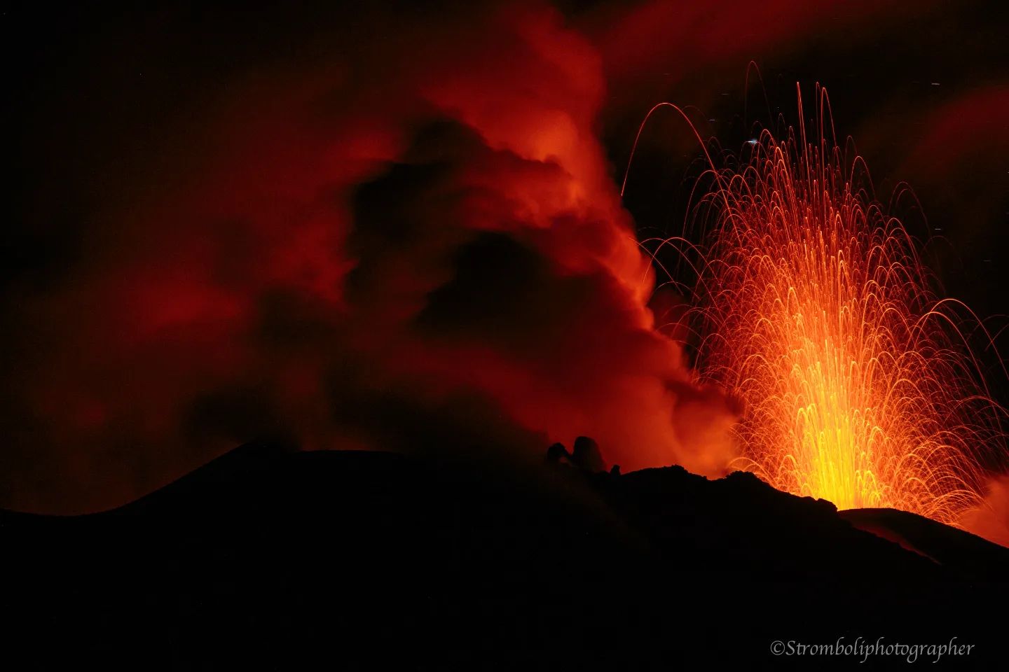
Italy , Stromboli :
WEEKLY BULLETIN, from September 12, 2022 to September 18, 2022 (Date of issue September 20, 2022)
ACTIVITY STATUS SUMMARY
In the light of the surveillance data, it is highlighted:
1) VOLCANOLOGICAL OBSERVATIONS: In this period a normal explosive activity of Strombolian type was observed. The total hourly frequency and intensity of explosions are comparable to those of the last few weeks (low) in both the North Crater Zone and the Center-South Crater Zone.
2) SEISMOLOGY: The seismological parameters monitored do not show any significant variations.
3) GROUND DEFORMATIONS: The ground deformation monitoring networks in operation on the island did not show any significant variations during the period studied.
4) GEOCHEMISTRY: SO2 flux at an average level.
The flux of CO2 from the soils in the summit zone is at medium to high values.
The C/S ratio in the plume emerges on average values (6.6).
Isotope ratio of Helium dissolved in heat sinks: it settles on medium-high values (4.36 Ra).
5) SATELLITE OBSERVATIONS: The thermal activity observed by satellite in the summit area was at a low level.
VOLCANOLOGICAL OBSERVATIONS
In the period under observation, there is only an update obtained thanks to the volcanological observations of the drones, since the problems of acquiring the video signals have persisted due to the damage to the optical fiber connecting Punta Labronzo and COA in due to the bad weather that hit the island on August 12, 2022 The latest updated data for the period from August 8 to August 14, 2022, places the total explosive activity at a medium-low level, with an intensity of the explosions between low and average in the areas of the North and Center-South craters.
Between September 13 and 14, observations of the activity of Stromboli were carried out remotely via drone, within the framework of the FIRST project (Prediction of the eruptive activity of the Stromboli volcano: moment, eruptive style, size, intensity and duration) and with the contribution of the surveillance activities of the Irpinia section of the INGV
During the September 14 surveys, the data indicated apparent temperatures within the three active craters above 575°C.
Source : INGV.
Photo : Stromboli Stati d’animo.
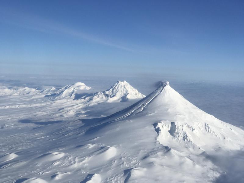
Alaska , Shishaldin :
AVO/USGS Volcanic Activity Notice
Current Volcano Alert Level: NORMAL
Previous Volcano Alert Level: UNASSIGNED
Current Aviation Color Code: GREEN
Previous Aviation Color Code: UNASSIGNED
Issued: Tuesday, September 20, 2022, 12:40 PM AKDT
Source: Alaska Volcano Observatory
Notice Number: 2022/A1045
Location: N 54 deg 45 min W 163 deg 58 min
Elevation: 9373 ft (2857 m)
Area: Aleutians
Volcanic Activity Summary:
Several seismic stations in the Shishaldin network are now operating after being offline over the past year. Data from these stations have improved the Alaska Volcano Observatory’s monitoring capability, and allows for location of small local earthquakes. Thus, the Aviation Color Code is now GREEN and the Volcano Alert Level NORMAL. The Alaska Volcano Observatory continues to monitor Shishaldin with the local seismic, infrasound, GPS, and tilt stations, web camera images, remote infrasound and lightning networks, and satellite images.
Remarks:
Shishaldin Volcano, located near the center of Unimak Island in the eastern Aleutian Islands, is a spectacular symmetric cone with a base diameter of approximately 16 km (10 mi). A 200-m-wide (660 ft) funnel-shaped summit crater typically emits a steam plume and occasional small amounts of ash. Shishaldin is one of the most active volcanoes in the Aleutian volcanic arc, with at least 54 episodes of unrest including over 24 confirmed eruptions since 1775. Most eruptions are relatively small, although the April-May 1999 event generated an ash column that reached 45,000 ft above sea level.
Source : AVO.
Photo : Jacob, Ben David
Chile , Nevados de Chillan :
Special Report on Volcanic Activity (REAV), Ñuble Region, Nevados de Chillán Volcanic Complex, September 19, 2022, 7:33 p.m. local time (mainland Chile)
The National Geology and Mining Service of Chile (Sernageomin) publishes the following PRELIMINARY information, obtained through the monitoring equipment of the National Volcanic Monitoring Network (RNVV), processed and analyzed in the Volcanological Observatory of the Southern Andes (Ovdas) :
On Monday September 19, 2022, at 7:13 p.m. (11:13 p.m. local time) the monitoring stations installed near the Nevados de Chillán volcanic complex recorded an earthquake, associated with fluid dynamics inside the volcanic system (long period type) .

The characteristics are as follows:
ORIGINAL TIME: 7:13 p.m. (11:13 p.m. local time)
LATITUDE: 36.862°S
LONGITUDE: 71.372° W
DEPTH: 0.4 km
REDUCED DISPLACEMENT: 740.3 (cm2)
ACOUSTIC SIGNAL: 7.4 Pascals (Pa) reduced to 1 km.
The characteristics of the surface activity associated with this event are as follows:
MAXIMUM HEIGHT OF THE EMISSION COLUMN: 1700 m above the emission point.
DIRECTION OF DISPERSION: Southeast.
COMMENTS:
The seismicity did not show any variations following the event described.
The volcanic technical alert remains at the yellow level.
Source : Sernageomin.
Photo : Explora turismo.
Hawaii , Kilauea :
19°25’16 » N 155°17’13 » W,
Summit Elevation 4091 ft (1247 m)
Current Volcano Alert Level: WATCH
Current Aviation Color Code: ORANGE
Activity Summary
Increased seismicity, ground deformation, and surface lava flows at Kīlauea’s summit—within Hawaiʻi Volcanoes National Park—occurred between 3 p.m. and 6 p.m. HST today, September 20. All activity was restricted to the summit region and there is no indication of activity migrating into either rift zone.
Beginning at 3 p.m., earthquake activity beneath Kīlauea Volcano’s summit began to increase, followed by summit inflation beginning around 4:20 p.m. New breakouts of lava began occurring on Halema’uma’u crater floor at 4:30 p.m.
This activity likely represented a temporary blockage in the eruption of lava at Halemaʻumaʻu, causing pressurization below the surface. This resulted in the earthquakes and ground inflation. Once the blockage was cleared, eruption of lava resumed with new breakouts occurring on Halemaʻumaʻu crater floor.
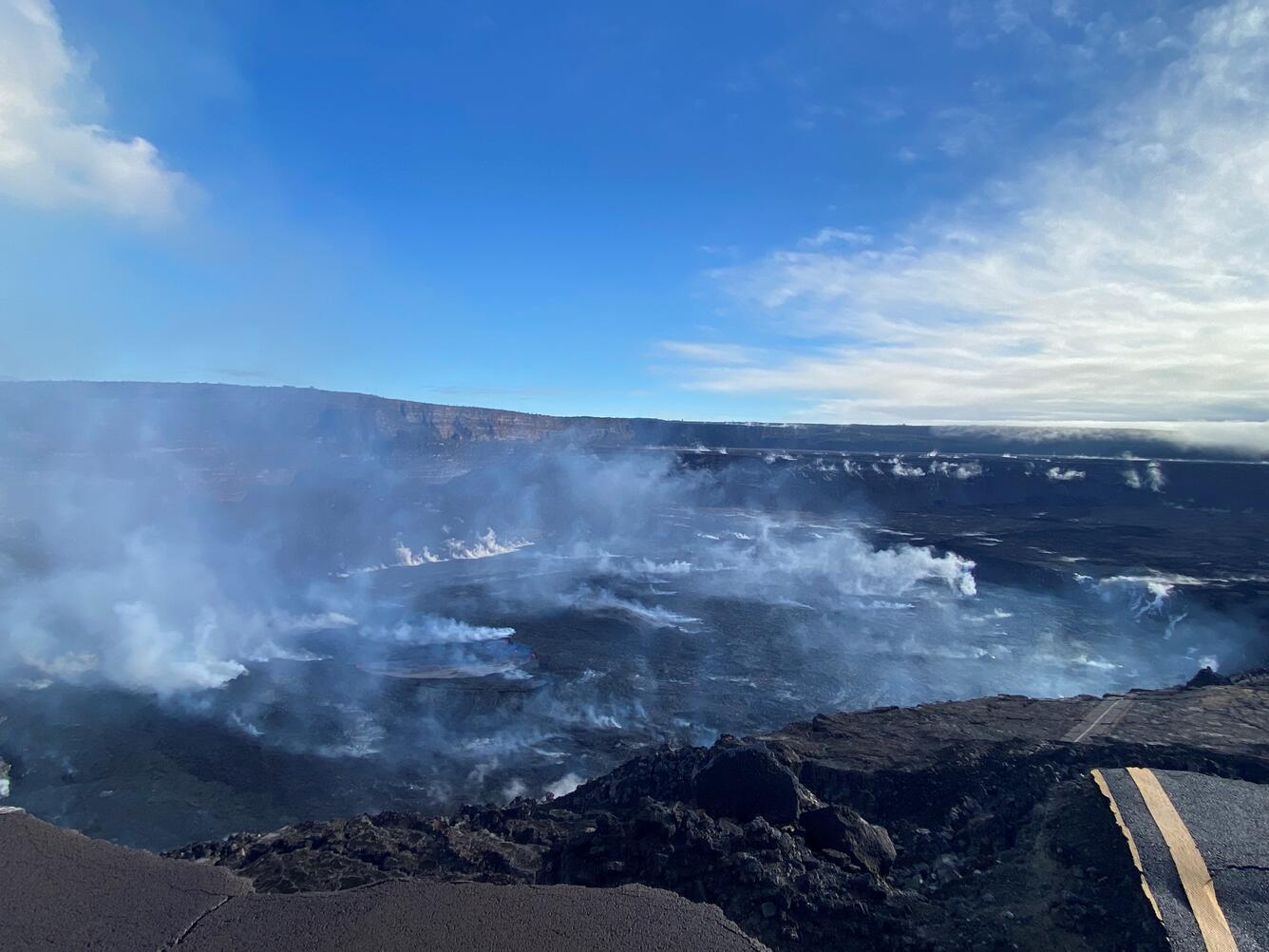
The steaming summit lava lake of Kīlauea in the 7 a.m. morning light of September 15. HVO geologists heard the west vent softly puffing and an insistent high-pitched hissing from the steaming northeastern embayment of the active lava pond in Halema‘uma‘u. A deeper toned hiss occasionally joined in from somewhere on the eastern side of the lake. Big shiny silvery plates of cooled crust flowed slowly across the surface of the active pond towards the eastern edge, where small splashes against the rim showed the hot glowing lava below.
Observations
Approximately 50 earthquakes were detected beneath Kīlauea summit between 3 p.m. and 6 p.m. today. Most earthquakes in this swarm occurred approximately 1 mile (1.5 kilometers) beneath Halemaʻumaʻu. The largest recorded earthquake was a magnitude 2.9, with the majority of the earthquakes being less than magnitude 2.
A rapid inflation of Kīlauea summit began around 4:20 p.m., coincident with a drop of 23-feet (7-meters) in the lava lake level. The crater floor surrounding the lava lake also subsided by several yards (several meters). New surface breakouts of lava occurred on the west and north margins of the crater floor. Approximately 12 microradians of inflationary ground tilt was measured at the UWE instrument over the following hour. Only minor ground deformation has been recorded at Kīlauea summit since approximately 5:30 p.m.; earthquake activity has returned to near background levels as of 6 p.m.
Source : HVO
Photo : USGS / J. Schmith