September 16 , 2022.
Tonga Islands , Home Reef :
The Tonga Geological Services reported that a new submarine eruption at Home Reef began at 01h39 on 10 September based on a volcanic gas plume detected in satellite images. By 12h59 material had formed a new small island, about 70 m in diameter and an estimated 10 m above the ocean surface. Gas emissions rose less than 1 km above the sea. Submarine activity was detected during 12-13 September, and a thermal anomaly was identified in a satellite image acquired at 14h00 on 13 September. The Aviation Color Code was raised to Yellow (the second lowest level on a four-color scale) and mariners were advised to stay 5 km away from the volcano. Gas emissions persisted at least through 14 September, with plumes rising less than 1 km.
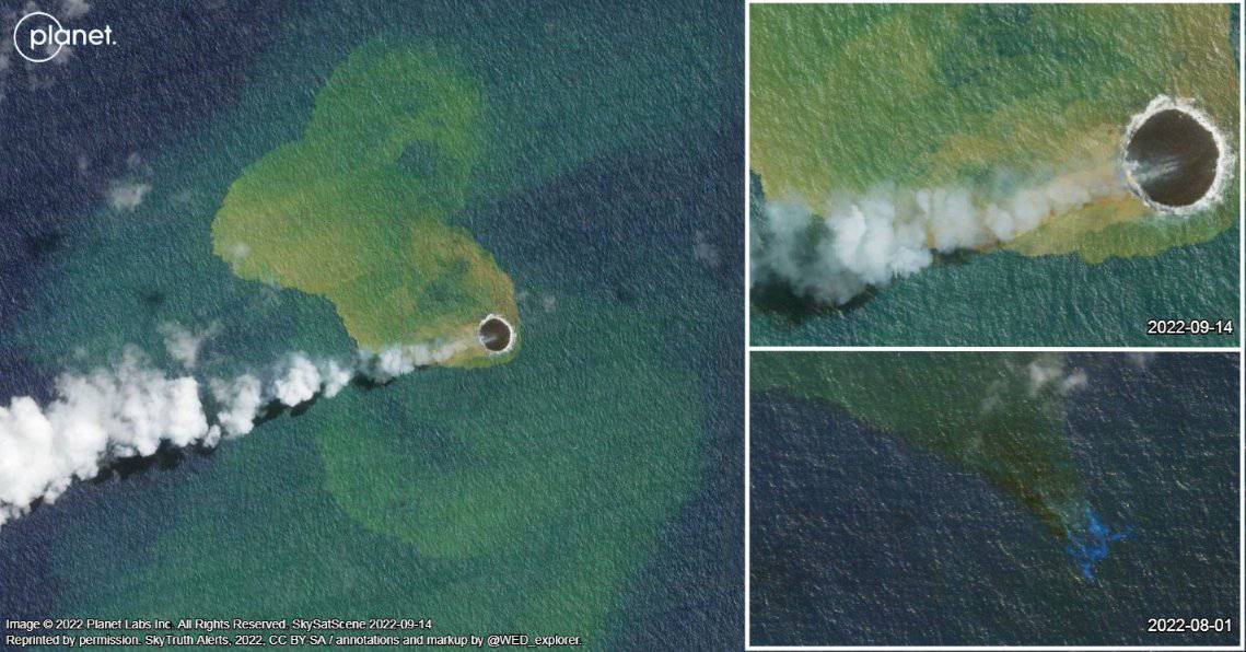
Home Reef, a submarine volcano midway between Metis Shoal and Late Island in the central Tonga islands, was first reported active in the mid-19th century, when an ephemeral island formed. An eruption in 1984 produced a 12-km-high eruption plume, copious amounts of floating pumice, and an ephemeral island 500 x 1500 m wide, with cliffs 30-50 m high that enclosed a water-filled crater. Another island-forming eruption in 2006 produced widespread dacitic pumice rafts that reached as far as Australia.
Source : GVP.
Photo : Worldview earth data / https://mobile.twitter.com/WED…/status/1570327874212700161
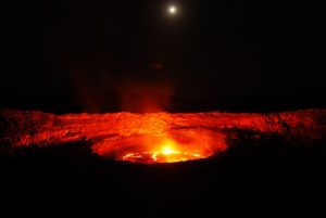
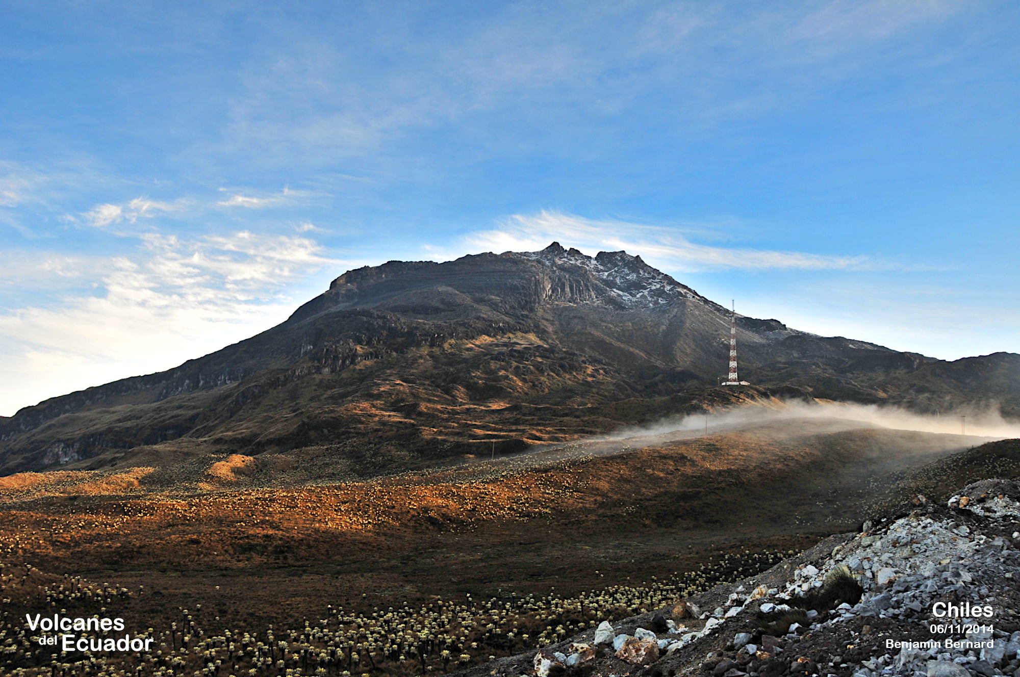
Colombia , Chiles / Cerro Negro :
Chiles and Cerro Negro volcanoes weekly activity bulletin
Volcano activity continues at YELLOW LEVEL ■ (III): CHANGES IN THE BEHAVIOR OF VOLCANIC ACTIVITY.
From monitoring the activity of VOLCANOES CHILES and CERRO NEGRO, the COLOMBIAN GEOLOGICAL SERVICE (SGC) reports that:
For the period evaluated, between September 6 and 12, 2022, compared to the previous weeks, the fluctuations in the behavior of volcanic activity continued, with a slight decrease in the occurrence and in the energy released by the tremors of earth, which were primarily associated with rock fracturing. This seismicity was located mainly on the southwestern slope of the Chiles volcanic edifice, at epicentral distances of up to 4 km, with depths less than 8 km from its summit (reference level at 4700 m) and magnitudes not exceeding 2.5. Another seismic source, less recurrent and energetic, although more dispersed, was located southeast of the Chiles volcano, at epicentral distances between 5 and 13 km, with depths between 6 and 12 km from the summit of the volcano. Chiles volcano and magnitudes below 1.9.
During the week evaluated, seven fracture earthquakes presented magnitudes greater than or equal to 2, highlighting the earthquakes of September 6 at 3:11 a.m. and September 12 at 7:35 a.m., both with a magnitude of 2.5. None of these seismic events were reported as felt by residents of the area of volcanic influence.
All these seismic manifestations are part of a process of ground deformation (observed instrumentally) which began at the end of March 2022 and continues to this day.
Based on the current behavior of this seismicity and what has been historically recorded in this active volcanic region, the possibility of the occurrence of more high-energy earthquakes, which can be felt by the inhabitants of the area of volcanic influence, is not excluded.
Source : Ingeominas.
Photo : Benjamin Bernard / Volcanes del Ecuador.
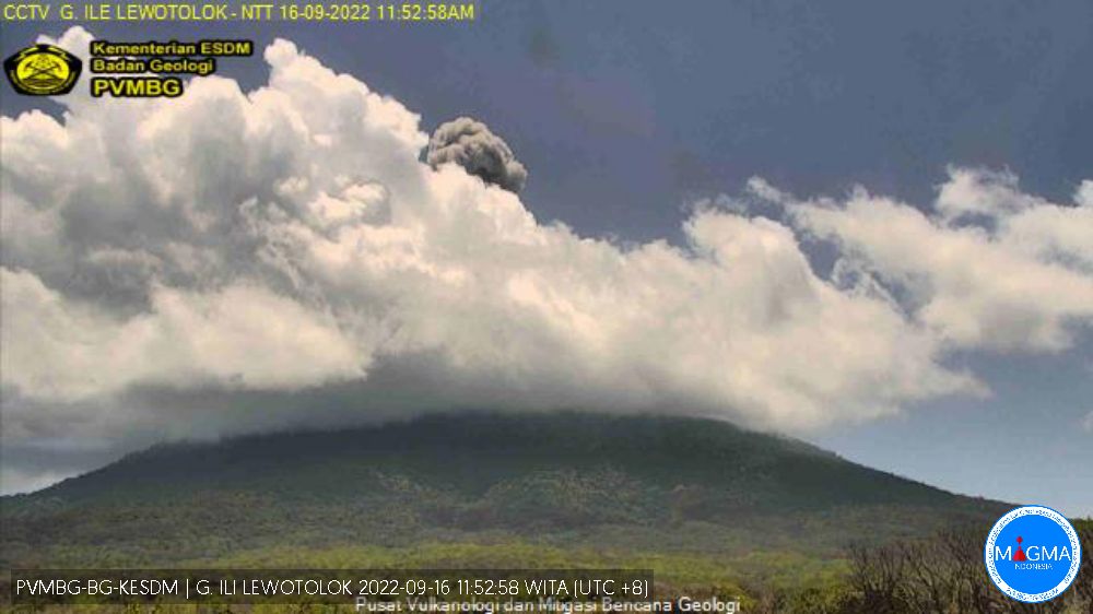
Indonesia , Ili Lewotolok :
Mount Ili Lewotolok showed an eruption on Friday September 16, 2022 at 11:51 a.m. WITA with an ash column height observed at ± 1500 m above the summit (± 2923 m above sea level). The ash column is observed to be gray with a thick intensity towards the southwest. This eruption was recorded on a seismograph with a maximum amplitude of 33 mm and a duration of 43 seconds.
VOLCANO OBSERVATORY NOTICE FOR AVIATION – VONA
Issued : September 15 , 2022
Volcano : Ili Lewotolok (264230)
Current Aviation Colour Code : ORANGE
Previous Aviation Colour Code : orange
Source : Ili Lewotolok Volcano Observatory
Notice Number : 2022LEW28
Volcano Location : S 08 deg 16 min 19 sec E 123 deg 30 min 18 sec
Area : East Nusa Tenggara, Indonesia
Summit Elevation : 4554 FT (1423 M)
Volcanic Activity Summary :
Eruption with volcanic ash cloud at 21h37 UTC (05h37local). Eruption and ash emission is not continuing.
Volcanic Cloud Height :
Best estimate of ash-cloud top is around 7754 FT (2423 M) above sea level, may be higher than what can be observed clearly. Source of height data: ground observer.
Other Volcanic Cloud Information :
Ash-cloud moving to west and northwest
Remarks :
Seismic activity is characterized by continuous volcanic tremor.
Source et photo : Magma Indonésie .
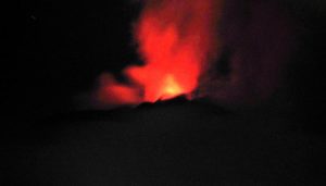
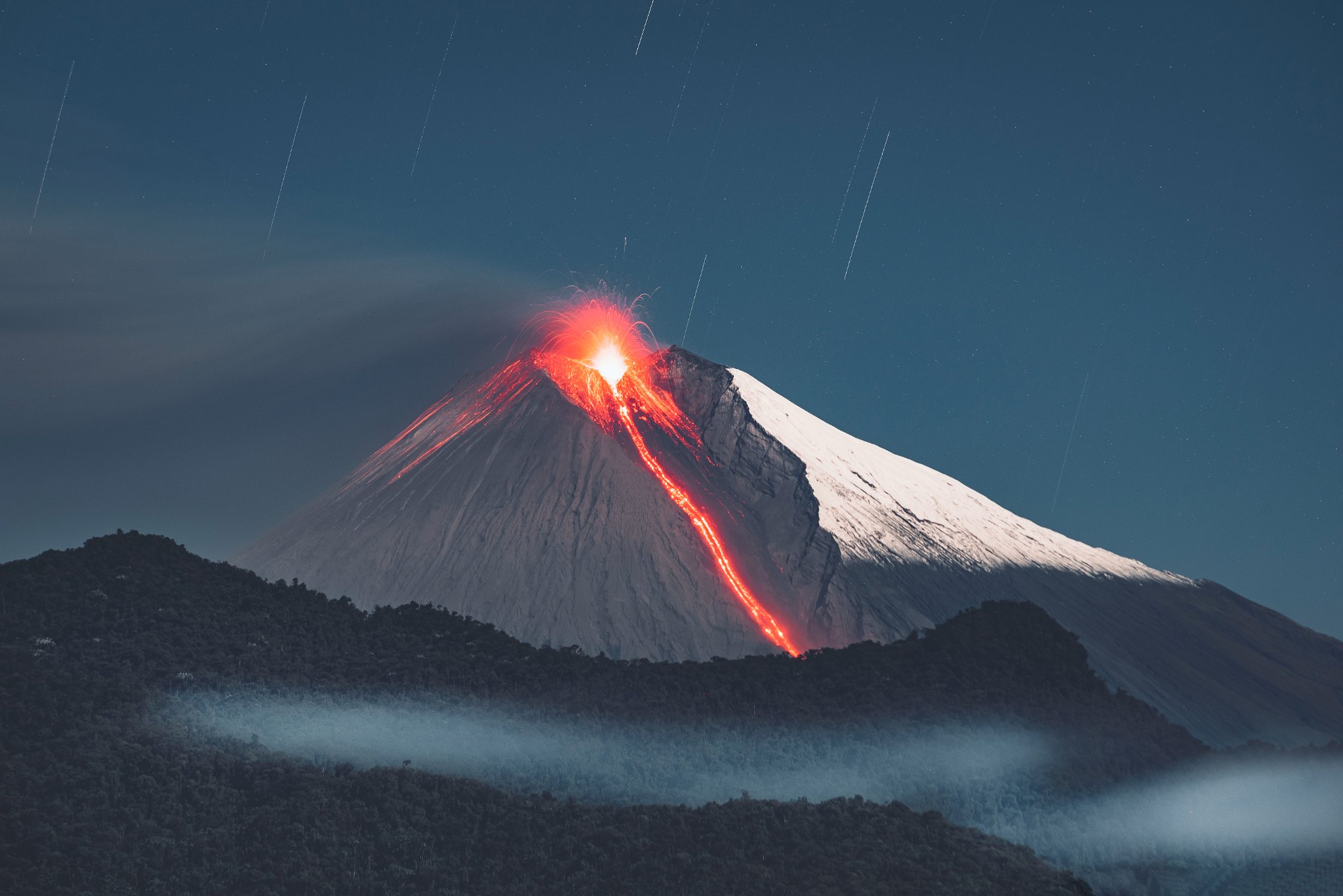
Ecuador , Sangay :
DAILY REPORT OF THE STATE OF SANGAY VOLCANO, Thursday September 15, 2022.
Information Geophysical Institute – EPN.
Surface Activity Level: High, Surface Trend: No change.
Internal activity level: High, Internal trend: No change.
Seismicity: From September 14, 2022. , 11:00 a.m. to September 15, 2022, 11:00 a.m.:
There were no cuts in the transmission of data from the reference station, so the seismic statistics are complete.
Explosion (EXP) 771
Long periods (LP) 156.
Rains / Lahars:
The Windy app recorded light rain in the area, which did not generate signals associated with diminishing mudslides and debris flows. **In the event of heavy rains, these could remobilize the accumulated materials, generating mudslides and debris that would descend on the flanks of the volcano and flow into the adjacent rivers.**
Emission / ash column:
The Washington VAAC reported 4 gas and ash emission alerts with a maximum height of 1,770 meters in a northwesterly direction.
Other Monitoring Parameters:
The MIROVA system records 1 high thermal alert (100 MW) and the FIRMS system records 8 thermal alerts on the Sangay in the last 24 hours.
Observation:
During the afternoon and night yesterday, the volcano cleared and the expulsion of incandescent material was observed. During the morning today, the volcano remained mostly cloudy.
Gas:
The MOUNTS system reported 599.9 tons of SO2, measured on 2022-09-14 at 18:33 UTC.
Alert level: Orange.
Source : IGEPN.
Photo : Lucas Scott / volcan Sangay.
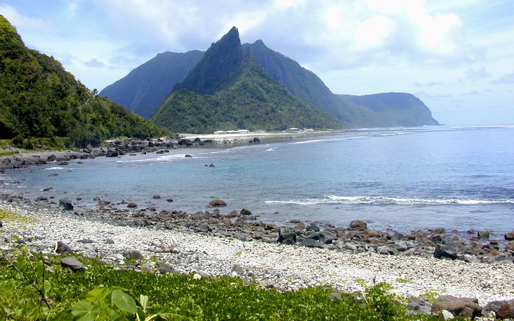
Samoa Islands , Ta’u :
14°13’48 » S 169°27’14 » W,
Summit Elevation 3054 ft (931 m)
Current Volcano Alert Level: ADVISORY
Current Aviation Color Code: YELLOW
The earthquake swarm related to Taʻū Island continues. Over the past 24 hours, seismicity remained low for the Manuʻa Islands. An earthquake at 7:36 a.m. American Samoa time had a magnitude similar to larger earthquakes earlier in this swarm; people on Ofu Island felt it. Seismologists analyzed this event and determined it occurred in the same location as earlier felt earthquakes. Thus, we observe no migration in the position of earthquake activity.
A fourth broadband seismometer was installed in American Samoa on Tutuila Island yesterday. As a result, data will be available on the Taʻū Island website interactive map tomorrow.
The satellite data from the previous 24 hours observed no volcanic activity.
Source : HVO.
Photo : rnz.co.nz
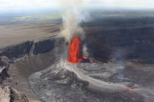
Hawaii , Kilauea :
19°25’16 » N 155°17’13 » W,
Summit Elevation 4091 ft (1247 m)
Current Volcano Alert Level: WATCH
Current Aviation Color Code: ORANGE
Activity Summary:
The summit eruption of Kīlauea Volcano, within Halemaʻumaʻu crater, continued over the past 24 hours. All recent eruptive activity has been confined to the crater. No significant changes have been observed at the summit or in either rift zone.
Halemaʻumaʻu Lava Lake Observations:
Eruption of lava from the western vent into the active lava lake and onto the crater floor continued over the past 24 hours. The active part of the lava lake showed continuous surface activity. Overflight measurements from September 12, 2022, indicated that the crater floor had seen a total rise of about 143 meters (469 feet),
since the beginning of this eruption on September 29, 2021.
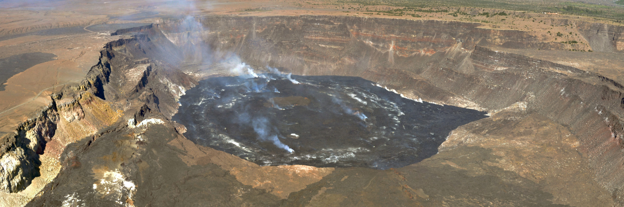
This panoramic image was taken during an early morning helicopter overflight on September 12, 2022, and shows the current Halema‘uma‘u lava lake at the summit of Kīlauea. The blocks that dropped down during the 2018 summit collapse events are visible around the central lake. Sections of Crater Rim Drive, which previously circumnavigated the caldera, can be seen on the left side of the image. The degassing on the lake surface occurs from numerous sources, including the main vent (back center of the image), several small hornitos (front center), and around the margins of the cracks in the lake.
Summit Observations:
Summit tiltmeters recorded relatively minor inflation over the past 24 hours. Volcanic tremor remains above background levels. A sulfur dioxide (SO2) emission rate of approximately 1300 tonnes per day (t/d) was measured on September 7, 2022.
Rift Zone Observations:
No unusual activity has been noted along the East Rift Zone or Southwest Rift Zone; low rates of ground deformation and seismicity continue along both. Summit tiltmeters recorded relatively minor deflation over the past 24 hours. Measurements from continuous gas monitoring stations downwind of Puʻuʻōʻō in the middle East Rift Zone remain below detection limits for SO2, indicating that SO2 emissions from Puʻuʻōʻō are negligible.
Source : HVO
Photo : USGS / L. Gallant.