June 13 , 2022.
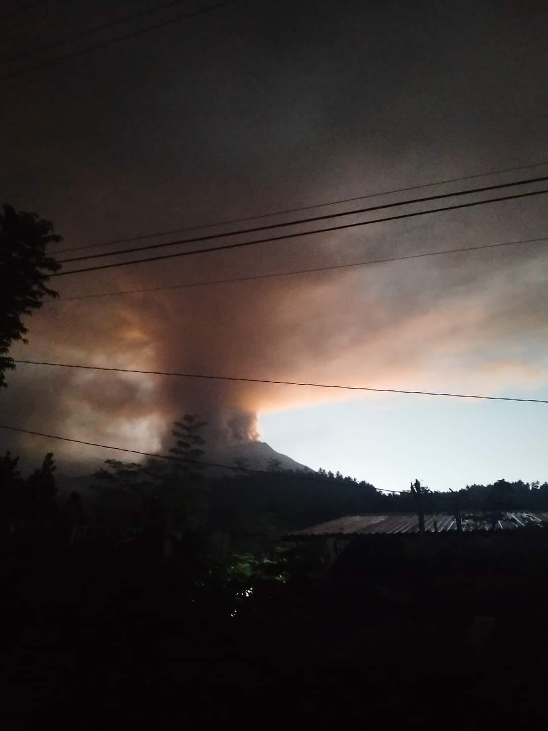
Philippines , Bulusan :
BULUSAN VOLCANO UPDATE, 12 June 2022 ,4:30 P.M.
At 3:37 AM this morning, an eruption was detected by the Bulusan Volcano Network. The eruption lasted for approximately 18 minutes and was recorded as an explosion-type earthquake by seismic and infrasound instruments, but could not be visually observed in the dark of night. The explosion was felt at Intensity III by residents of Brgy. Añog, Juban and at Intensity II in Brgy. Inlagadian, Casiguran, all within 5-km of the Bulusan summit. Rumbling sounds accompanying the eruption were also reported by witnesses in Sitio Bagong Barrio, Brgy. Santa Lourdes, Barcelona, Brgy. Inlagadian and Brgy. San Juan, Casiguran, Brgy. Bentuco, Gubat, and Brgys. Añog, Calateo, and Puting Sapa, Juban. A brief incandescence at the base of the eruption plume was also reported in Brgy. Inlagadian, Casiguran. By daybreak, multiple active vents at the summit could be observed spewing ash and steam to a height of at least 500 m before being drifted to the northwest. In the morning, six vents – the major crater called Blackbird, three explosion pits on the summit, and the lateral vents on the northwest and north sides of the summit – were actively degassing short plumes which entrained ash until at least 9:00 in the morning. The plumes dispersed into a long veil of ash extending several kilometers to the northwest. This period of “ashing” was accompanied by very weak sporadic volcanic tremor. Degassing of steam-laden plumes continues while the Blackbird Crater generates a thin haze of ash upon the upper northwestern slopes.
Field data as of this bulletin’s issuance time verify thin ashfall on the following barangays and municipalities of Sorsogon Province:
Casiguran, Cogon, Inlagadian, San Juan, Tulay,Juban , Añog, Aroroy, Bacolod, Buraburan, Calateo, Lajong , Mabini, Puting Sapa, Tublijon ,
Magallanes , Incarizan, Pili, Sta. Elena, Tula-tula
Aeolian or wind-drifted ash was reported in Sorsogon City and Palanas, Pilar, Sorsogon Province across Sorsogon Bay and as far as Anislag, Daraga, Albay, 50 kilometers northwest of Bulusan.
Fine ashfall can cause irritation and breathing problems especially among the vulnerable population – the elderly, children, expectant mothers and those with respiratory disorders – and can be particularly dangerous when inhaled in copious amounts.
Alert Level 1 status remains in effect over Bulusan as all other monitoring parameters as of this time indicate that current unrest is driven by the volcano’s restive hydrothermal system. Local government units and the public are reminded that entry into the 4-kilometer radius Permanent Danger Zone (PDZ) must be strictly prohibited and that vigilance in the 2-kilometer Extended Danger Zone (EDZ) on the southeast sector must be exercised due to the increased possibilities of sudden and hazardous phreatic eruptions that can occur without warning. Civil aviation authorities must also advise pilots to avoid flying close to the volcano’s summit as ash from any sudden phreatic eruption can be hazardous to aircraft. Furthermore, people living within valleys and along river/stream channels especially on the southeast, southwest and northwest sector of the edifice should be vigilant against sediment-laden stream flows and lahars in the event of heavy and prolonged rainfall should phreatic eruption occur.
DOST-PHIVOLCS is closely monitoring Bulusan Volcano’s condition and any new development will be communicated to all concerned stakeholders.
Source : Phivolcs.
Photos : Kyle Aranza, Sam Gerrits .
Italy / Sicily , Etna :
Communique on the activity of Etna, June 12, 2022, 22:17 (20:17 UTC).
The National Institute of Geophysics and Volcanology, Osservatorio Etneo, announces that an inspection carried out today by the staff of the INGV Osservatorio Etneo, has found that, compared to what is reported in the press release Previously, at an altitude of about 1900 m, near the fracture system that developed in the north wall of the Valle del Bove in the Serracozzo region, three effusive vents are active, the most advanced front of which has reaches about 1750 m. In addition, the effusive activity at the level of the vent which opened on June 7 a little further upstream from the same area at an altitude of approximately 1980 m remains. Regarding the effusive vents that developed on May 29 between 2900 and 2700 m a.s.l., today only the lowest vent at around 2700 m was active. Finally, during the inspection and from the surveillance cameras, sporadic emissions of ash from the Southeast Crater were observed, which quickly dispersed near the summit area.
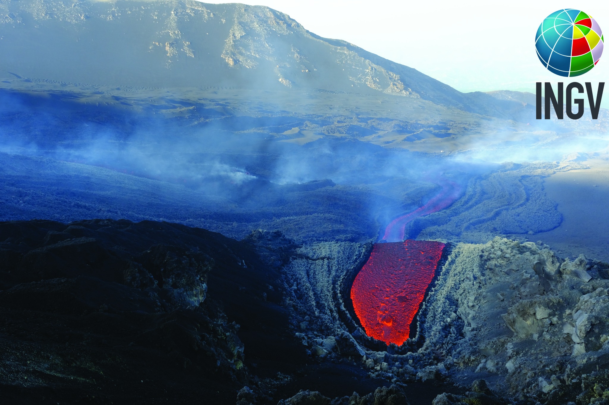
The average amplitude of the volcanic tremor, after the phase of slight and gradual increase reported yesterday, at the beginning of today’s afternoon suffered a decrease while remaining within the range of average values. The sources of the tremor are located between the Bocca Nuova and the Southeast Crater, at an altitude of about 3000 m. Infrasound activity is moderate and mainly located in correspondence with the Bocca Nuova Crater.
The stations of the inclinometric and GNSS network do not show any significant deformations of the ground.
Further updates will be communicated soon.
Source : INGV.
Photo : INGV-OE Francesco Ciancitto e Daniele Andronico.
Alaska , Semisopochnoi :
51°55’44 » N 179°35’52 » E,
Summit Elevation 2625 ft (800 m)
Current Volcano Alert Level: WATCH
Current Aviation Color Code: ORANGE
Low-level eruptive activity continues with minor ash emissions visible intermittently in web camera images over the past day during periods of clear weather. These small ash clouds rose hundreds of feet above the vent and quickly dispersed. Periods of seismic and infrasound tremor continue to be observed on the local network.
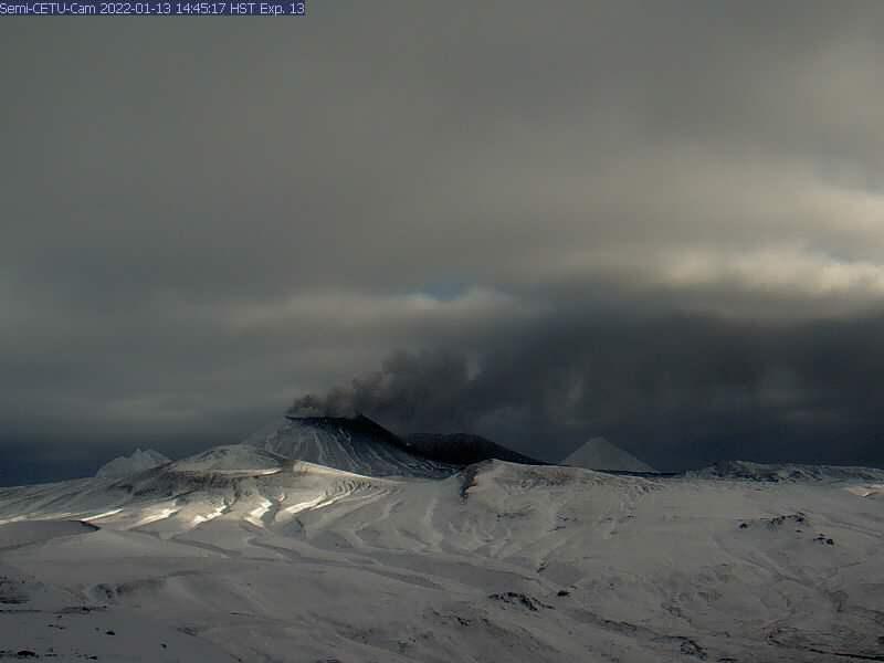
Small eruptions producing minor ash deposits within the vicinity of the active north crater of Mount Cerberus and ash clouds usually under 10,000 ft (3 km) above sea level have characterized the recent activity. Small explosions and associated ash emissions may continue and could be difficult to detect, especially when thick cloud cover obscures the volcano.
Semisopochnoi is monitored by local seismic and infrasound sensors, satellite data, web cameras, and remote infrasound and lightning networks.
Source : AVO
Photo : Alaska Volcano Observatory / U.S. Geological Survey
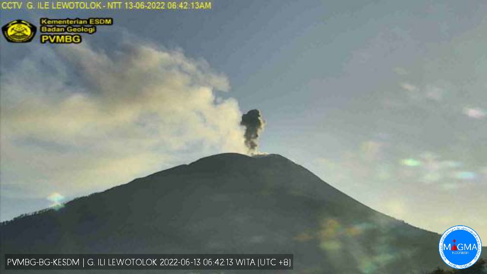
Indonesia , Ili Lewotolok :
VISUAL OBSERVATION:
The volcano is clearly visible until it is covered by fog. Smoke from the crater is white / gray with low to moderate intensity, about 500-1000 meters above the summit. The weather is sunny to cloudy, the wind is light to the west and northwest.
CLIMATE:
The air temperature is around 22.8-28.7°C. Humidity 69.2-83.5%.
SEISMICITY OBSERVATION:
We record:
12 earthquakes of eruptions/explosions with an amplitude of 8.8 to 33.4 mm and a duration of 32 to 79 seconds.
56 emission earthquakes with an amplitude of 2.3 to 15 mm and a duration of 27 to 99 seconds.
23 non-harmonic tremors with an amplitude of 2.6 to 12.7 mm and a duration of 84 to 237 seconds.
1 deep volcanic earthquake with an amplitude of 5.6 mm, S-P 0.68 seconds and a duration of 6.8 seconds.
1 continuous tremor with an amplitude of 0.5 mm, dominant value of 0.5 mm.
RECOMMENDATION
[1] Based on the results of a thorough analysis and assessment, on June 8, 2022, the activity level of the Ili Lewotolok volcano is still at level III (SIAGA) with new recommendations adapted to the latest potential dangers .
[2] At Level III (Siaga) activity level, people around Mount Ili Lewotolok as well as visitors/climbers/tourists are recommended not to carry out activities within 3 km of the summit / crater of Mount Ili Lewotolok, 3.5 km radius for the South-East sector, and a radius of 4 km for the East and North-East sectors. Residents of Lamawolo Village, Lamatokan Village and Jontona Village should always be aware of the potential threat of incandescent lava and hot clouds from the eastern part of G. Ili Lewotolok peak/crater
Source and photo : Magma Indonésie .
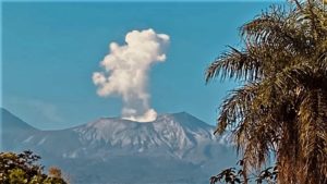
Ecuador , Reventador :
DAILY REPORT OF THE STATE OF THE REVENTADOR VOLCANO, Sunday June 12, 2022.
Information Geophysical Institute – EPN.
Surface Activity Level: High, Surface Trend: No change.
Internal activity level: Moderate, Internal trend: No change.
Seismicity: From June 11, 2022, 11:00 a.m. to June 12, 2022, 11:00 a.m.:
Explosion (EXP) 29
Long Periods (LP) 76
Emission Tremors (TREMI ) 3
Harmonic Tremors (TRARM): 1
Rains / Lahars:
Rains were recorded in the area without generating lahars.
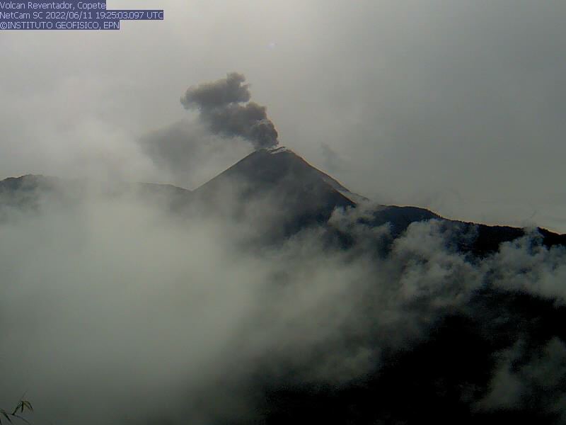
Emission / ash column:
In the afternoon of yesterday Saturday, 2 emissions of gas and ash were observed, which reached heights between 600 and 1000 meters, taking directions from West to South-West. The Washington VAAC agency issued 2 emission alerts with heights of 988 meters above crater level and with directions to the West and Northwest, respectively.
Other Monitoring Parameters:
No thermal alerts have been issued for Reventador Volcano in the past 24 hours.
Observation:
For most of the time, the volcano area remained cloudy. There are no observations through the camera system.
Alert level: Orange.
Source : IGEPN
Photos : IGEPN