May 31 , 2022.
Back at work, the holidays are over….
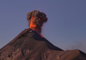
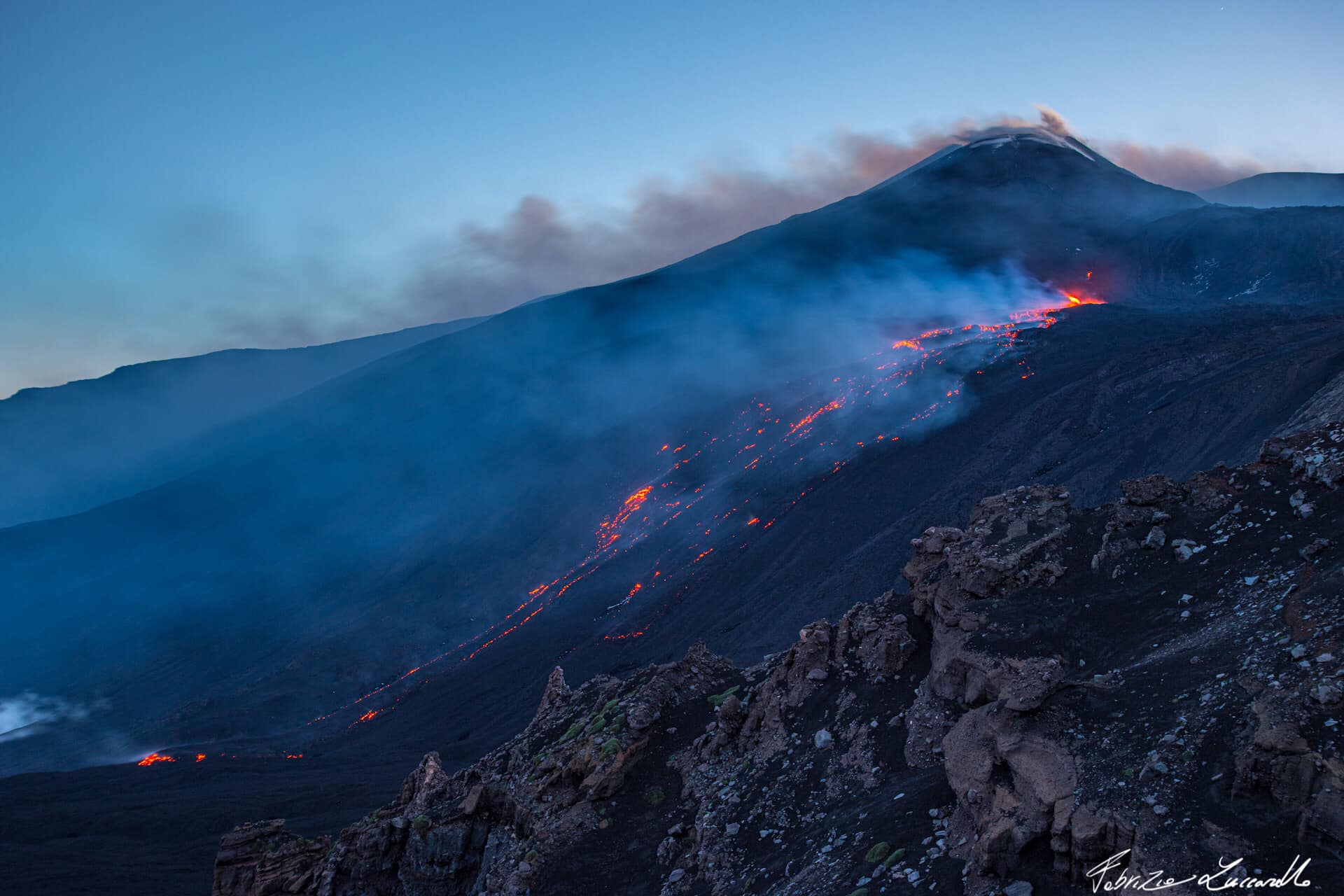
Italy / Sicily , Etna :
Communique on the activity of Etna, May 29, 2022, 09:50 (07:50 UTC).
The National Institute of Geophysics and Volcanology, Osservatorio Etneo announces that at 06:05 UTC an effusive vent opened in the upper part of the Valle del Bove. The altitude of the lava emission point is about 2800 m above sea level.
The average amplitude of the tremor, after a rapid decrease observed in the afternoon of day 28, oscillates on medium-high values. The location of the sources is in the area of the Southeast crater at a depth of about 3000 meters. Infrasound activity is weak and localized in the Bocca Nuova crater area.
The ground deformation signals recorded by the permanent GNSS and tilt monitoring networks over the past few hours do not show any significant variations.
Communique on the activity of Etna, May 29, 2022, 21:02 (19:02 UTC).
The National Institute of Geophysics and Volcanology, Osservatorio Etneo announces that from the inspection carried out in the afternoon, it was observed that two effusive vents opened on the side of the Southeast Crater, the first lies at an altitude of about 3250 m, a second at the lowest altitude around 2800 m.
The effusive rate at the time of the sightings was low and the flow was moving inside the Valle del Bove towards Monte Simone. The most advanced lava fronts reached an altitude of about 2100 m.
The amplitude of the tremor, after an increase observed in the morning, is stationary in the high range. The signal sources are located in the area of the Southeast Crater at an altitude of approximately 3000 m. The infrasonic signal is affected by wind noise. Based on the records, activity appears to be low.
Regarding the deformations of the ground, there are no significant variations at the stations of the GNSS and Tilt networks.
Further updates will be communicated soon.
Source : INGV.
Photos : Fabrizio Zuccarello – Escursioni guidate sull’Etna
Iceland , Reykjanes Peninsula :
Yesterday morning at 09:20h an earthquake of magnitude M4.1 occurred 8 km NNW of Gjögurtá in North Iceland. Earlier last night, at 01:51h a M3.5 and at 05:27 a M2.8 were measured in the same parts. IMO has received reports that people felt these earthquakes in the North and Northeast Iceland felt these earthquakes.
Seismic activity continues in Svartsengi on Reykjanes Peninsula During the seismic unrest on the Reykjanes Peninsula the likelihood of a large (M6.0 – M6.5) earthquake have increased in Brennisteinsfjöll.
Landslides can occur in slopes and mountain sides because of strong earthquakes close to Eldvörp on the Reykjanes Peninsula.
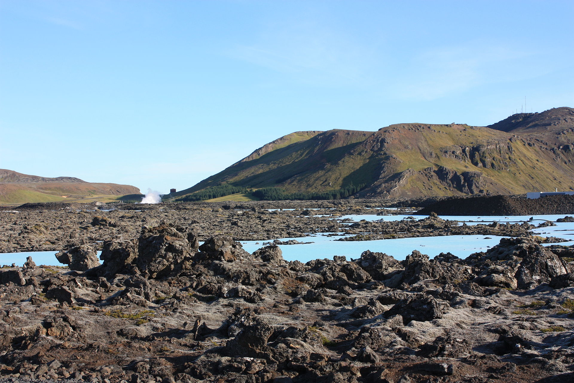
IMO reported an ongoing seismic swarm and uplift on the Reykjanes Peninsula, indicative of a magma intrusion. Satellite data analysis indicated that 4-4.5 cm of uplift occurred during 27 April-21 May centered just NW of Mt. Thorbjorn. Magma was accumulating at depths of 4-5 km, and the intrusion was possibly 7-8 km long. During 22-23 May about 400 earthquakes were recorded; a M 3 earthquake was recorded at 1113 on 22 May and a M 3.5 earthquake was recorded at 0715 on 23 May, both were located about 3 km E of Mt. Thorbjorn. The Aviation Color Code for Reykjanes remained at Yellow.
Sources : Vedur is , GVP.
Photo : Thorbjörn et Blue_Lagoon , Arian Zwegers
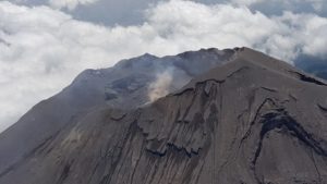
Kamchatka , Bezymianny :
VOLCANO OBSERVATORY NOTICE FOR AVIATION (VONA)
Issued: May 28 , 2022
Volcano: Bezymianny (CAVW #300250)
Current aviation colour code: ORANGE
Previous aviation colour code: orange
Source: KVERT
Notice Number: 2022-50
Volcano Location: N 55 deg 58 min E 160 deg 35 min
Area: Kamchatka, Russia
Summit Elevation: 2882 m (9452.96 ft)
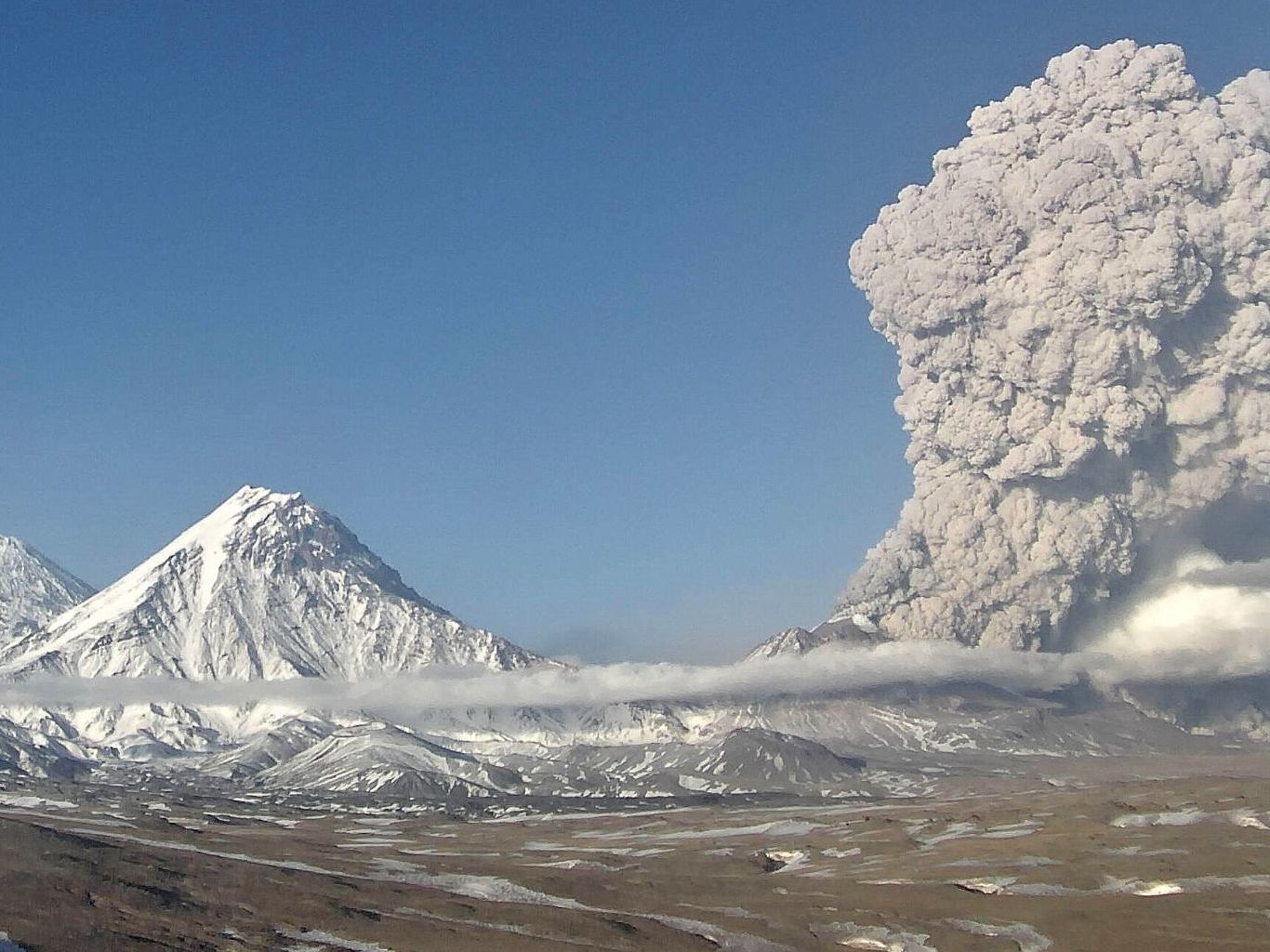
Volcanic Activity Summary:
The paroxysmal phase of the explosive eruption has ended, but the eruptive activity of the volcano with the removal of some amount of ash up to 4.5 km a.s.l. continues. Satellite data by KVERT show: gas-steam plume with some amount of ash is extending for 45 km to the southeast of the volcano; but the large ash cloud about 1635 long also continues to move the southeast of the volcano.
The moderate eruptive activity of the volcano continues. Ongoing activity could affect low-flying aircraft.
Volcanic cloud height:
4500-5000 m (14760-16400 ft) AMSL Time and method of ash plume/cloud height determination: 20220528/2200Z – Video data
Other volcanic cloud information:
Distance of ash plume/cloud of the volcano: 45 km (28 mi)
Direction of drift of ash plume/cloud of the volcano: SE / azimuth 134 deg
Time and method of ash plume/cloud determination: 20220528/2130Z – Himawari-8
Source : Kvert.
Photo : Webcam Kvert.
Italy , Stromboli :
Where does human stupidity lead…
Stromboli: big fire on the small volcanic island after a voluntary fire start for the filming of a television series
More than six hectares of Mediterranean maquis went up in smoke, for an episode of « Protezione Civile » on Italian public television. Residents are angry.
« Protezione Civile »: this is the name of a series of RAI, the Italian public television. It has never been so badly named since an episode was filmed on the small volcanic island of Stromboli, off the coast of Sicily. “But how could they start a fire when the sirocco was blowing. How can someone who shoots a fiction on Civil Protection not know this? “, gets angry in the Corriere della Serra Marco Giorgianni, the mayor of Lipari, another Aeolian island, on which Stromboli and its 750 inhabitants depend.
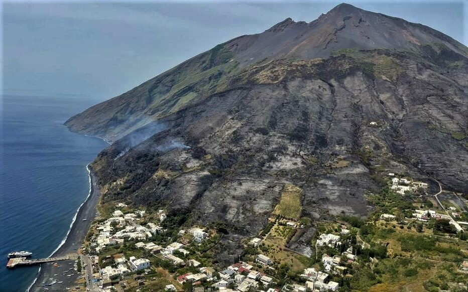
On May 26, technical teams would be mounted on the volcano to light a fire. The false service of « Protezione Civile » was to circumscribe it in less than two seconds. But there, the scenario would have quickly slipped. The sirocco, this wind coming from the Sahara violent, very dry and very hot, fanned the embers.
More than six hectares of Mediterranean maquis went up in smoke. “We are talking about about 50% of the green area of the island destroyed” estimates the regional civil protection.
Source : Le Parisien.
Read the article : Stromboli : gros incendie sur la petite île volcanique après un départ de feu volontaire pour le tournage d’une série télévisée – Le Parisien
Photo : stromboli stati d’animo.
Chile , Villarica :
Special Volcanic Activity Report (REAV), La Araucanía Region – Los Ríos Region, Villarrica volcano. May 24, 2022, 12:00 p.m. local time (mainland Chile).
The National Geology and Mining Service of Chile (Sernageomin) discloses the following information obtained through the monitoring equipment of the National Volcanic Monitoring Network (RNVV), processed and analyzed at the Volcanological Observatory of the Southern Andes (OVDAS) , regarding the recent activity of the Villarrica volcano:
Seismology
Since the beginning of the previous month, there has been an increase in the amount of daily long-period (LP) type seismicity. This seismic activity generally presented reduced displacement (DR) values of less than 30 cm2, however, as mentioned in the RAV of the previous month, an earthquake recorded on April 26 stands out, which had a value of DR equal to 77cm2. So far in May, DR values of LP seismicity are generally less than 13 cm2, with a few pinpoint earthquakes with values up to 23 cm2, highlighting an event with a DR of 50 cm2 on May 22, which did not present any associated acoustic signal. Concerning the analysis of the continuous signal, quantified from the RSAM, the values calculated for the month of May fluctuate between 0.2 and 0.4 µm/s, values considered low.

Fluid Geochemistry
Data on sulfur dioxide (SO2) emissions obtained by means of optical differential absorption spectroscopy (DOAS) equipment, corresponding to the Tralco station, installed 6 km to the East-South-East (ESE ) of the active crater, presented an average value of 282 ± 50 t / d (between May 1 and 22), with a maximum daily average of 654 t / d on May 6. According to the activity of the volcano, these values remain at levels considered low.
Satellite thermal anomalies
On May 17, a thermal alert was recorded in the area associated with the volcano with a Volcanic Radiative Power (VRP) of 2 MW, a value considered low according to data processed by the Middle Infrared Observation of Volcanic Activity (MIROVA) (http : //www.mirovaweb.it/). In addition, through the analysis of Sentinel 2L2A satellite images, 6 radiance anomalies were detected on May 3, 5, 10, 13, 15 and 18, with a maximum anomalous radiance area of 6300 m2 on May 15.
Observations:
According to the antecedents exposed, a process of superficialization of the lava lake is evidenced, which in turn generated an increase in long-period type seismicity, the recording of acoustic signals, incandescence and an increase in thermal alerts recorded. As observed in previous phases, the dynamics of the lava lake in its process of restitution to shallow levels can lead to punctual increases in activity such as those observed on April 26 and May 22, which could generate explosions minor with ejection of pyroclasts in the crater area and its area of influence. Consequently, the zoning of the hazard is modified, considering an area likely to be affected by volcanic products within a radius of 300 m from the edge of the active crater.
The volcanic technical alert is maintained at the Green level.
Source : Sernageomin
Read the article : https://rnvv.sernageomin.cl/rnvv/TI_Santiago_prod/reportes_LB/2022/REAV_20220524_1200_Villarrica.pdf
Photo : Volcanologia en Chile .
Guatemala , Fuego :
SPECIAL VOLCANOLOGICAL BULLETIN, VOLCÁN DE FUEGO
Type of activity: Vulcanian
Morphology: Stratovolcano composite
Geographical location: Latitude 14°28’54˝N; longitude 90°52’54˝W.
Altitude: 3,763 meters.
LAHAR IN THE BARRANCA EL JUTE, TRIBUTARY OF THE ACHIGUATE RIVER
The rains in the Southeast area of the volcanic complex are currently generating a lahar in the Barranca El Jute, a tributary of the Achiguate River, with weak to moderate characteristics, but with the probability of increasing in the next few minutes due to the rains. that persist within the area. The lahar descends with fine volcanic material, in addition to carrying branches and tree trunks, as well as blocks from 30 cm to 1.5 meters in diameter. If the rain persists, the generation of larger lahars in this ravine or in other nearby ravines, such as the Las Lajas ravine, is not excluded.
Source : Insivumeh