May 15 , 2022.
Italy / Sicily , Etna :
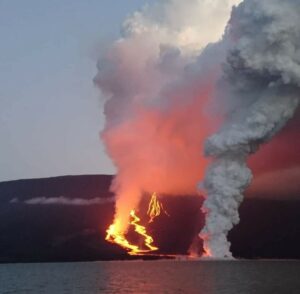
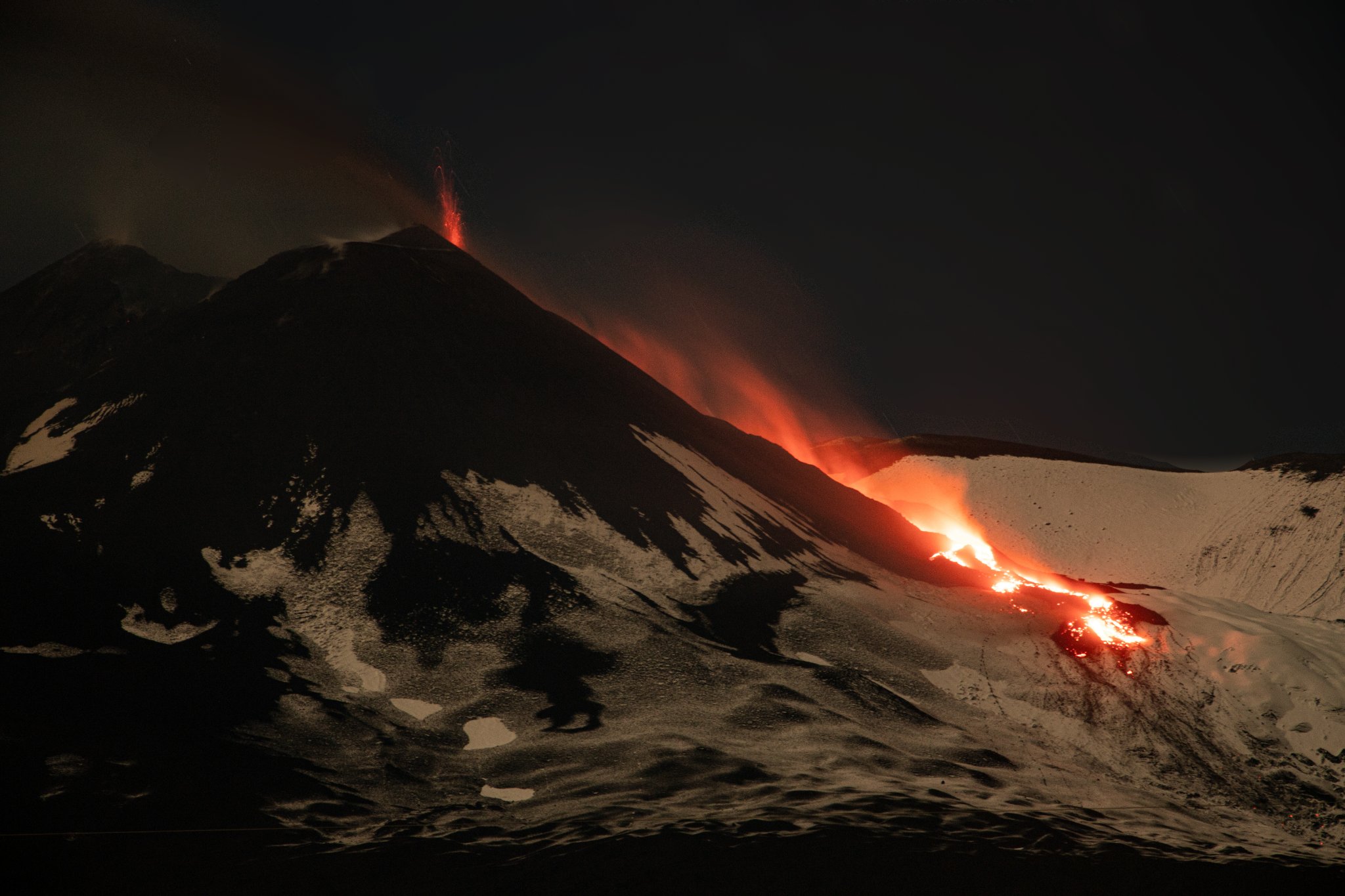
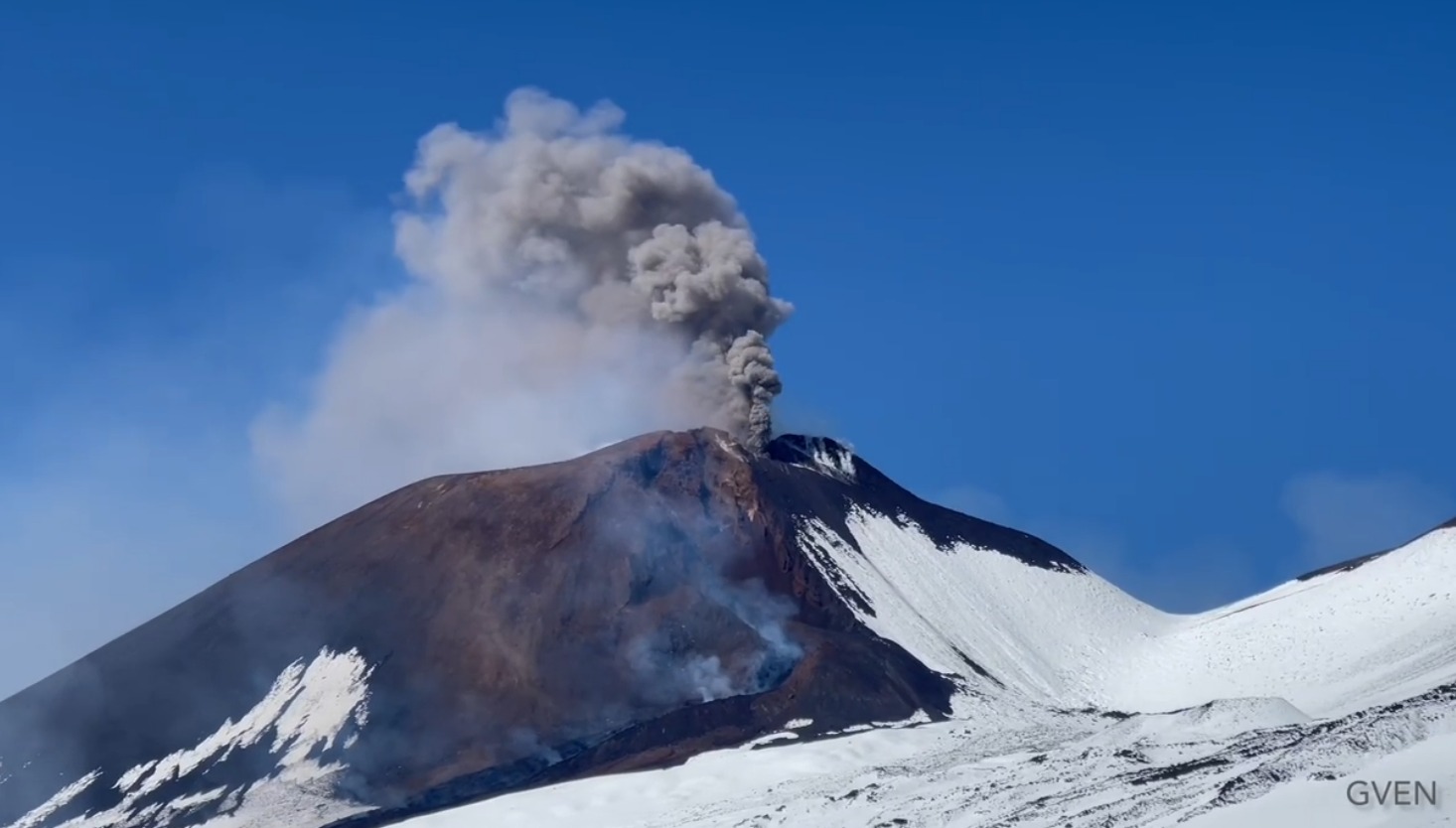
The southeast crater of Etna shows itself with a new character: soft, quiet, almost tender, without that wild violence that has characterized its activity over the past year. For two days, the lava has been flowing slowly from a fracture on its north side, feeding an elongated flow, becoming more and more magnificent on these mythical evenings of this long-awaited spring.
VOLCANO OBSERVATORY NOTICE FOR AVIATION (VONA)
Issued: May 12 , 2022
Volcano: Etna 211060
Current Color Code: ORANGE
Previous Color Code: yellow
Source: Etna Volcano Observatory
Notice Number: 2022/0028/01N01
Volcano Location: 3744N 01500E
Area: Italy
Summit Elevation: 3300 m
Volcanic Activity Summary:
LAVA FLOW IS OBSERVED AT SUMMIT CRATERS
Volcanic cloud height:
NO ASH CLOUD IS PRODUCED
Other volcanic cloud information:
VOLCANIC ASH IS CONFINED TO THE SUMMIT AREA
Remarks:
THE PHENOMENON IS OBSERVED BY VISIBLE AND THERMAL SURVEILLANCE CAMERAS
Source : Boris Behncke , INGV.
Photos : Guide Alpine Vulcanologiche Etna.
Kamchatka , Karymsky :
VOLCANO OBSERVATORY NOTICE FOR AVIATION (VONA)
Issued: May 13 , 2022
Volcano: Karymsky (CAVW #300130)
Current aviation colour code: ORANGE
Previous aviation colour code: orange
Source: KVERT
Notice Number: 2022-34
Volcano Location: N 54 deg 2 min E 159 deg 26 min
Area: Kamchatka, Russia
Summit Elevation: 1486 m (4874.08 ft)
Volcanic Activity Summary:
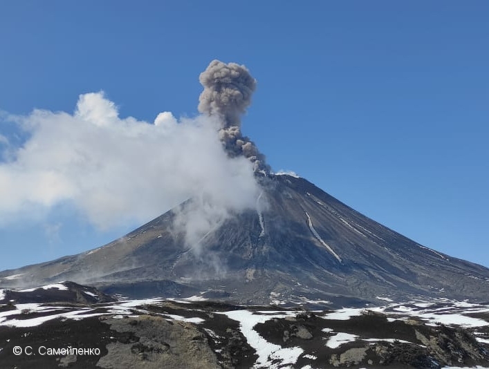
A moderate eruptive activity of the volcano continues. The explosions sent ash up to 5.7 km a.s.l., the ash plume is extending for 28 km to the northeast of the volcano.
A moderate explosive activity of the volcano continues. Ash explosions up to 12 km (39,400 ft) a.s.l. could occur at any time. Ongoing activity could affect international and low-flying aircraft.
Volcanic cloud height:
5500-5700 m (18040-18696 ft) AMSL Time and method of ash plume/cloud height determination: 20220513/2140Z – Himawari-8
Other volcanic cloud information:
Distance of ash plume/cloud of the volcano: 28 km (17 mi)
Direction of drift of ash plume/cloud of the volcano: NE / azimuth 44 deg
Time and method of ash plume/cloud determination: 20220513/2140Z – Himawari-8
Source : Kvert
Photo : S. Samoylenko.
Iceland , Reykjanes Peninsula :
At 16:56 an earthquake of magnitude 4.8 occurred in Þrengslin east of Lambafell at 8km depth. The earthquake was felt in south and west Iceland. Aftershocks may be expected.
Earthquake activity is ongoing in the Reykjanes peninsula. Five earthquakes above magnitude 3 were been recorded just off Reykjanestá yesterday. At 19:28 a magnitude 3.2 earthquake occured, at 17:04 a 3,1, at 16:41 a magnitude 3.3, at 15:41 a magnitude 3.5 and at 11:09 yesterday morning an earthquake of magnitude 3.4 was located in the same area.
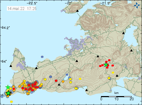
MAY 14, 2022 . Strong earthquake in Brennisteinsfjöll volcano .
Today (14-May-2022) at 16:56 UTC an earthquake with magnitude of Mw4,8 took place in Brennisteinsfjöll volcano. This earthquake was clearly felt in Reykjavík, Selfoss and large parts of south and south-west Iceland. Depth of this earthquake seems to be 7,8 km.
Sources : Vedur is , icelandgeology.net
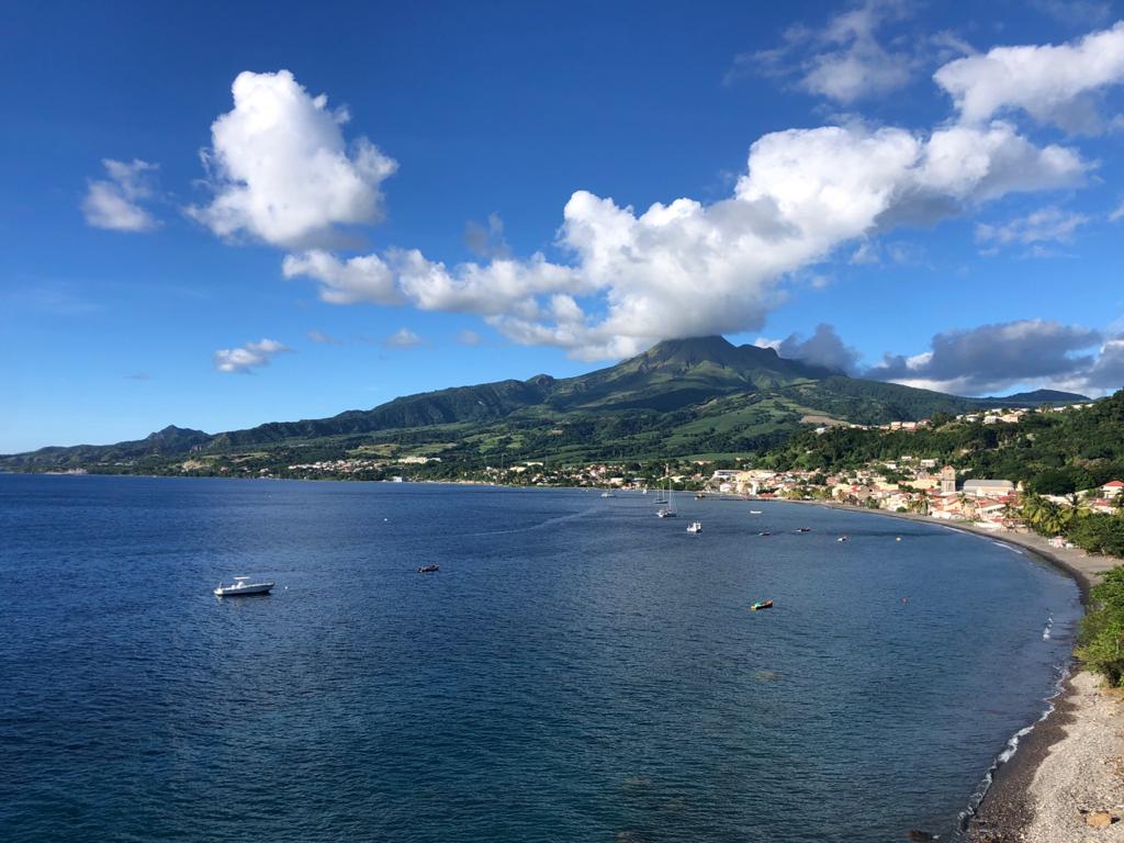
La Martinique , Mount Pelée :
Weekly report on the activity of Mount Pelee for the period from May 06 to 13, 2022.
Between May 06, 2022 at 4 p.m. (UTC) and May 13, 2022 at 4 p.m. (UTC), the OVSM recorded at least 8 volcano-tectonic earthquakes of magnitude less than or equal to 0.1. These low-energy earthquakes were located inside the volcanic edifice about 0.7 km deep below the surface. This superficial volcano-tectonic seismicity is associated with the formation of micro-fractures in the volcanic edifice. During the period of this report, the OVMS also recorded 1 hybrid-type earthquake of magnitude equal to 1.1, located about 18 km deep below the surface. This signal containing low frequencies are associated with the presence of fluids (gas, hydrothermal waters) inside the Caribbean Plate, located under the volcanic edifice.
None of these earthquakes were felt by the population.
The zone of degassing at sea at shallow depth between St Pierre and le Prêcheur is still observed. The IGP took fluid samples in order to understand the origin of this degassing and to assess its possible relationship with the Mount Pelée hydrothermal system.
An extension of two areas of degraded vegetation located between Morne Plumé and the Chaude River was observed during a helicopter flight carried out on February 9, with the support of the Dragon 972, and confirmed by analysis of satellite images.
The alert level remains YELLOW: vigilance.
Source : Direction de l’OVSM IPGP.
Photo : rci.fm .
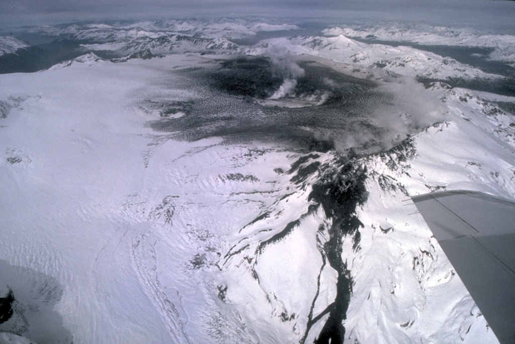
Chile , Hudson :
Seismology
The seismological activity of the period was characterized by the recording of:
661 VT-type seismic events, associated with rock fracturing (Volcano-Tectonics). The most energetic earthquake presented a value of local magnitude (ML) equal to 2.3, located 7.6 km south-south-east of the center of the caldera, at a depth of 4.8 km by relative to the crater.
176 LP-type seismic events, associated with fluid dynamics within the volcanic system (Long Period). The size of the largest earthquake estimated from the reduced displacement parameter (RD) was equal to 25 cm2.
1 TR-type seismic event, associated with sustained dynamics over time of the fluids inside the volcanic system (TRemor). The size of the tremor evaluated from the reduced displacement parameter (RD) was equal to 2 cm2.
31 HB-type seismic events, associated with both rock fracturing and fluid dynamics within the volcanic system (HyBrid). The most energetic earthquake presented a reduced displacement value (DR) of 400 cm2 and a local magnitude value (ML) equal to 2.7, located 6.9 km south-southwest of the center of the caldera, at a depth of 5.1 km in reference to the crater.
Fluid Geochemistry
No anomalies were reported in the emissions of sulfur dioxide (SO2) into the atmosphere in the area near the volcanic system, according to data published by the Tropospheric Monitoring Instrument (TROPOMI) and Ozone Monitoring Instrument (OMI) Sulfur Dioxide Group (http://so2.gsfc.nasa.gov/).
Satellite thermal anomalies
During the period, no thermal alert was recorded in the area associated with the volcanic system, according to data processed by the Medium Infrared Observation of Volcanic Activity (MIROVA) (http://www.mirovaweb.it /) and by the analytical processing of Sentinel 2-L2A satellite images, in combination with false color bands.
Geodesy
According to data provided by 2 GNSS stations, only variations associated with cyclical seasonal changes were recorded, a situation considered normal. No deformation anomalies attributable to changes in the internal dynamics of the volcano were observed during the evaluated period.
Surveillance cameras
The images provided by the fixed camera installed near the volcanic system did not record degassing columns or variations related to surface activity.
Activity remained at levels considered low, suggesting stability of the volcanic system. The volcanic technical alert is maintained at: GREEN TECHNICAL ALERT: Active volcano with stable behavior – There is no immediate risk.
Source : Sernageomin
Photo : Norm Banks, 1991 (U.S. Geological Survey).
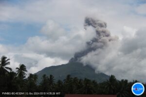
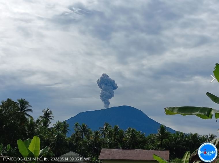
Indonesia , Ibu :
VOLCANO OBSERVATORY NOTICE FOR AVIATION – VONA
Issued : May 14 , 2022
Volcano : Ibu (268030)
Current Aviation Colour Code : ORANGE
Previous Aviation Colour Code : orange
Source : Ibu Volcano Observatory
Notice Number : 2022IBU34
Volcano Location : N 01 deg 29 min 17 sec E 127 deg 37 min 48 sec
Area : North Maluku, Indonesia
Summit Elevation : 4240 FT (1325 M)
Volcanic Activity Summary :
Eruption with volcanic ash cloud at 09h07 UTC (18h07 local).
Volcanic Cloud Height :
Best estimate of ash-cloud top is around 7440 FT (2325 M) above sea level, may be higher than what can be observed clearly. Source of height data: ground observer.
Other Volcanic Cloud Information :
Ash-cloud moving to southeast.
Remarks :
Eruption and ash emission is continuing.
Source et photo : Magma Indonésie .