May 01 , 2022.

A little happiness for all.
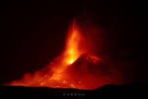
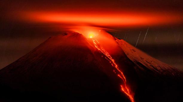
Indonesia , Semeru :
VOLCANO OBSERVATORY NOTICE FOR AVIATION – VONA
Issued : April 30 , 2022.
Volcano : Semeru (263300)
Current Aviation Colour Code : ORANGE
Previous Aviation Colour Code : orange
Source : Semeru Volcano Observatory
Notice Number : 2022SMR125
Volcano Location : S 08 deg 06 min 29 sec E 112 deg 55 min 12 sec
Area : East java, Indonesia
Summit Elevation : 11763 FT (3676 M)
Volcanic Activity Summary :
Pyroclastic flow occured from the edge of lava deposit at 23:30 UTC ( 0630 local )
Volcanic Cloud Height :
Best estimate of ash-cloud top is around 13363 FT (4176 M) above sea level, may be higher than what can be observed clearly. Source of height data: ground observer.
Other Volcanic Cloud Information :
Ash-cloud moving to southwest
Remarks :
Lava flow is observed through the southeast direction of the Semeru Summit Crater
Source : Magma Indonésie.
Photo : Oystein Lund Andersen.
Alaska , Semisopochnoi :
51°55’44 » N 179°35’52 » E,
Summit Elevation 2625 ft (800 m)
Current Volcano Alert Level: WATCH
Current Aviation Color Code: ORANGE
Low-level eruptive activity continues. Tremor was observed in seismic data but there have been no explosions in last day. The volcano was obscured by clouds in satellite and webcam images.
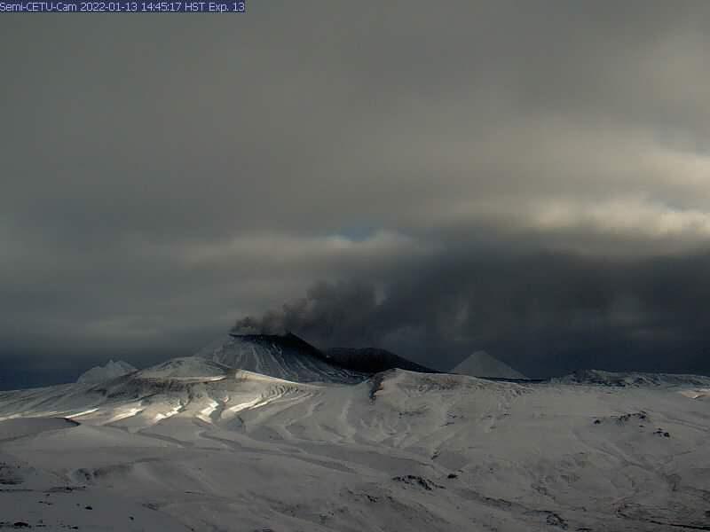
Small eruptions producing minor ash deposits within the vicinity of the active north crater of Mount Cerberus and ash clouds usually under 10,000 ft (3 km) above sea level have characterized the recent activity. Small explosions and associated ash emissions may continue and could be difficult to detect, especially when thick cloud cover obscures the volcano.
Semisopochnoi is monitored by local seismic and infrasound sensors, satellite data, web cameras, and remote infrasound and lightning networks.
Source : AVO
Photo : Alaska Volcano Observatory / U.S. Geological Survey
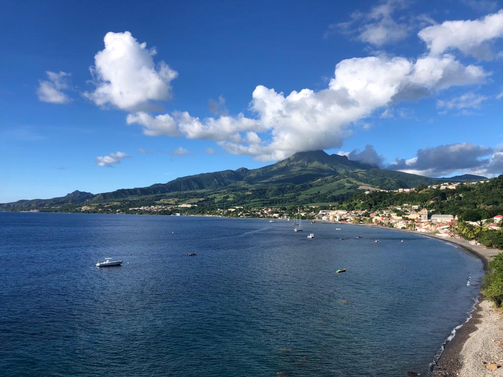
La Martinique , Mount Pelée :
Weekly report on the activity of Mount Pelée for the period from April 22 to 29, 2022.
Between April 22, 2022 at 4 p.m. (UTC) and April 29, 2022 at 4 p.m. (UTC), the OVSM recorded at least 51 volcano-tectonic earthquakes of magnitude less than or equal to 1.0, including 24 earthquakes which of are produced during the day of April 28. These low-energy earthquakes were located inside the volcanic edifice between 0.7 and 1.4 km deep below the surface. This superficial volcano-tectonic seismicity is associated with the formation of micro-fractures in the volcanic edifice. During the period of this report, the OVMS also recorded 5 hybrid-type earthquakes. These signals containing low frequencies are associated with the presence of fluids (gas, hydrothermal waters) in the volcanic edifice.
None of these earthquakes were felt by the population.
The zone of degassing at sea at shallow depth between St Pierre and le Prêcheur is still observed. The IGP took fluid samples in order to understand the origin of this degassing and to assess its possible relationship with the Mount Pelée hydrothermal system.
An extension of two areas of degraded vegetation located between Morne Plumé and the Chaude River was observed during a helicopter flight carried out on February 9, with the support of the Dragon 972, and confirmed by analysis of satellite images.
Based on analysis of satellite imagery, this area, consisting of topless, defoliated or downed tree trunks and ferns, and yellowing grasses and bushes, appeared in late 2019. It is located near the craters of the historic phreatic eruptions of 1792 and 1851.
The gas measurement mission at this zone of deteriorated vegetation carried out on February 8, 2021 shows the presence of diffuse and passive degassing of carbon dioxide (CO2, an odorless and colorless gas) locally reaching maximum concentrations of 5000 to 7800 ppm.
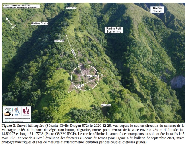
At the heart of the most deteriorated vegetation zone, fractures 20 to 60 cm wide and 2 to 3 m deep are visible on the ground (Figure 3) and can be followed over several tens of meters. Some of these fractures are clearly old but others, very frank and in which the dead vegetation has collapsed, could have formed very recently although their age is not known. There is no fumarole, emission of water vapor, or gas escaping visibly from an orifice or crack. Markers on the ground were installed on March 5, 2021 around the most important fractures so as to be able to follow their evolution over time.
The alert level remains YELLOW: vigilance.
Source : Direction de l’OVSM IPGP.
Photos : rci.fm , OVSM IPGP
Read the full article: https://www.ipgp.fr/fr/ovsm/bilans-hebdomadaires
Ecuador , Sangay :
DAILY REPORT OF THE STATE OF SANGAY VOLCANO. Saturday April 30, 2022.
Surface Activity Level: High, Surface Trend: No change.
Internal activity level: High, Internal trend: Ascending.
Seismicity: From April 29, 2022, 11:00 a.m. to April 30, 2022, 11:00 a.m.:
Long periods (LP): 339
Explosions ( EXP): 21
Emission tremor (TREMI: 4
Harmonic Tremor (TRARM): 1
Lahar (HL): 1
Rains / Lahars:
Over the past 24 hours, several rain events have generated signals associated with the descent of mudslides and debris. **As a precautionary measure, it is recommended not to enter or approach the beds of the Sangay Norte, Culebrillas, Palora, Volcán and Upano rivers.**
Emission / ash column:
Thanks to the cameras, no emission was observed, however, the VAAC recorded 2 ash emission alerts observed on satellites which bordered heights of 900 and 1200 meters above the level of the crater in a West direction.
Other Monitoring Parameters:
The FIRMS satellite system recorded 7 thermal alerts on the Sangay volcano in the past 24 hours.
Observation:
Weather conditions in the area prevented direct observations of surface activity.
Alert level: Orange.
Update.
Yesterday, from approximately 07:15 TL and until the issuance of this bulletin, the SAGA seismic station continues to record seismic signals corresponding to the descent of mudslides and debris (lahars) on the Sangay volcano at following the continuous rains that have registered in the sector.
This phenomenon has been recurrent since the start of activity in May 2019 and is due to the fact that the rains on the volcano remobilize the abundant volcanic material accumulated in recent weeks. As a precautionary measure, it is recommended not to enter or approach the beds of the Sangay Norte, Culebrillas, Palora, Volcán and Upano rivers.
Source : IGEPN.
Photos :EFE.
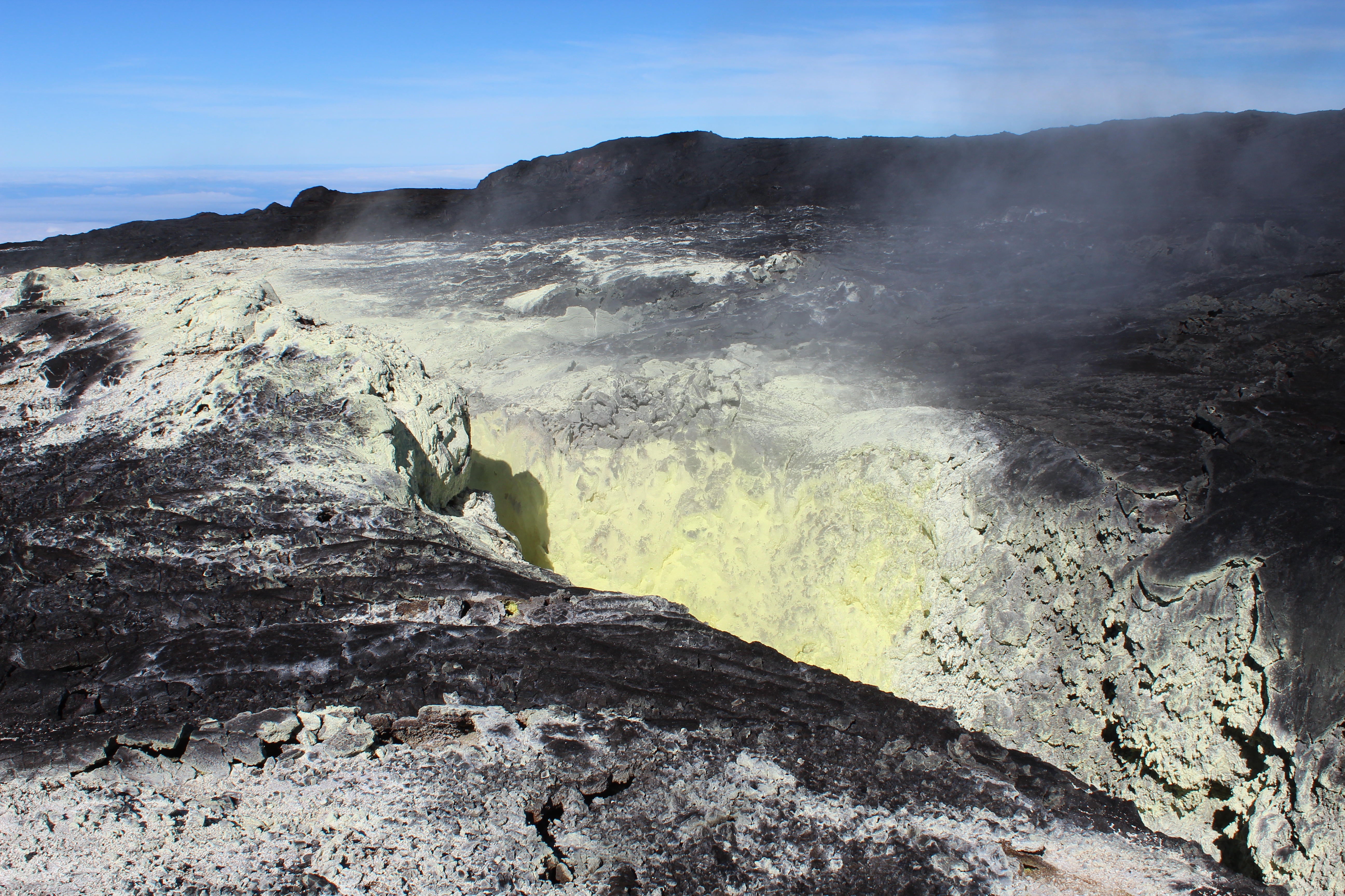
Hawaii , Mauna Loa :
19°28’30 » N 155°36’29 » W,
Summit Elevation 13681 ft (4170 m)
Current Volcano Alert Level: ADVISORY
Current Aviation Color Code: YELLOW
Activity Summary:
Mauna Loa Volcano is not erupting. Rates of seismicity remain slightly elevated above long-term background levels, but have not changed significantly over the past week. Other Mauna Loa monitoring data streams—ground deformation, gas concentrations, visual appearance in webcams—show no significant changes.
Observations:
During the past week, HVO seismometers recorded approximately 55 small-magnitude (below M3.0) earthquakes below the summit and upper-elevation flanks of Mauna Loa. The majority of these earthquakes occurred at shallow depths less than 15 kilometers (9 miles) below sea level.
Global Positioning System (GPS) measurements show low rates of deformation in the volcano’s summit region continuing through the past week.
Concentrations of sulfur dioxide (SO2), hydrogen sulfide (H2S), and carbon dioxide (CO2), as well as fumarole temperatures, remain stable at both the summit and at Sulphur Cone on the upper Southwest Rift Zone.
Webcam views have shown no changes to the volcanic landscape on Mauna Loa over the past week.
Source et photo : HVO.