April 20 , 2022.
Italy , Stromboli :
WEEKLY BULLETIN, from April 11, 2022 to April 17, 2022. (issue date April 19, 2022)
ACTIVITY STATUS SUMMARY
In the light of the surveillance data, it is highlighted:
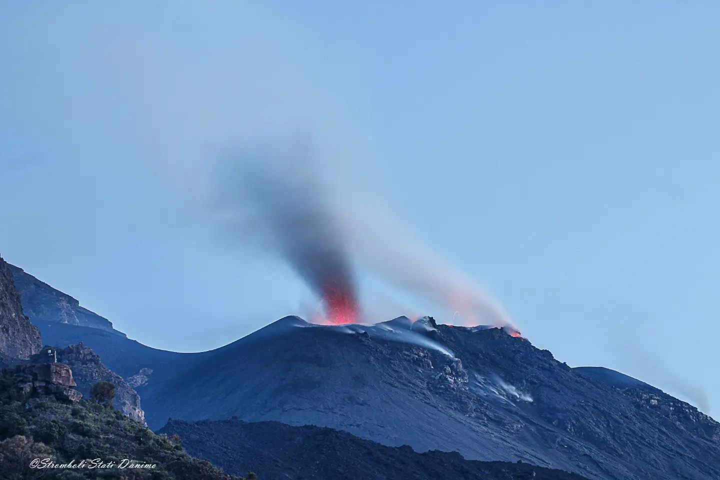
1) VOLCANOLOGICAL OBSERVATIONS: During this period, normal explosive activity of the Strombolian type was observed with intense spattering activity in the N zone. The total hourly frequency of explosions oscillated between average values (13 events/h) and medium-high (17 events/h). The intensity of the explosions ranged from low to high in the North Crater area and from low to medium in the South Center Crater area.
2) SEISMOLOGY: The seismological parameters monitored do not show any significant variations.
3) GROUND DEFORMATIONS: No significant variation is reported in the tilt and GNSS data time series
4) GEOCHEMISTRY: SO2 flux at a medium-high level.
CO2 flux in the crater area on high values.
Due to technical issues, there are no updates on the C/S ratio in the plume.
Isotope ratio of Helium dissolved in heat sinks at high values (sample of April 5, 2022).
5) SATELLITE OBSERVATIONS: The thermal activity observed by satellite was at a low level.

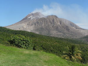
VOLCANOLOGICAL OBSERVATIONS
During the observation period, the eruptive activity of Stromboli was characterized through the analysis of images recorded by the INGV-OE surveillance cameras (altitude 190m, Punta Corvi, altitude 400m and Pizzo). The explosive activity was mainly produced by 5 (five) eruptive vents located in the North crater area and 2 (two) eruptive vents located in the Center-South crater area. All the mouths are located inside the depression which occupies the terrace of the crater.
Observations of eruptive activity from surveillance cameras:
Sector N1 located in the area of the North crater produced high intensity explosions (greater than 150 m in height) emitting coarse materials (lapilli and bombs). Sector N2, with four emission points, showed explosive activity of medium-low intensity (less than 120 m in height) emitting coarse materials with intense projection activity during long intervals on April 12 and 16. The average frequency of explosions varied from 8 to 12 events/h.
In the Center-South zone, sectors C and S1 did not show significant explosive activity. Sector S2, with two emission points, had explosions of medium and low intensity (the products of the explosions often exceeded 80 m in height) emitting coarse materials. The frequency of the explosions varied between 4 and 6 events/h.
Field Observations of April 11, 2022 eruptive activity:
As part of the activities carried out by the UN departmental project, an inspection was carried out in the summit area on April 11. Below is a description of the observations of the technical-scientific staff:
The central sector (C) currently consists of a large crater, subcircular in shape and totally inactive also in terms of degassing (S1 also inactive) while the S2 sector is formed by a deep depression with 2 main openings, a mouth near from the central sector which produces episodic but prolonged and dense emissions of ash which disperse rapidly upwards, generally associated with the Strombolian activity of the southernmost chimney. In the N1 sector, there is a large asymmetrical hornito open towards the Sciara, with a main vent that produces continuous splashes and discontinuous explosions consisting of powerful vertical jets loaded with coarse materials. Generally during these explosions at least one other smaller vent is activated between N1 and N2 and sometimes a third behind N2. N2 itself can activate with weak Strombolian activity both alone and following explosions of N1. The activity at N1 seems to be linked to the sleepless nights of the Strombolians, who for several days have been experiencing continuous vibrations of doors and windows. The violent wind of the past few days has caused a relapse of centimetric lapilli between the Pizzo and the Elipista-Roccette junction.
Source : INGV.
Photos : INGV , Stromboli stati d’animo.
Kamchatka , Karymsky :
VOLCANO OBSERVATORY NOTICE FOR AVIATION (VONA)
Issued: April 20 , 2022
Volcano: Karymsky (CAVW #300130)
Current aviation colour code: ORANGE
Previous aviation colour code: red
Source: KVERT
Notice Number: 2022-28
Volcano Location: N 54 deg 2 min E 159 deg 26 min
Area: Kamchatka, Russia
Summit Elevation: 1486 m (4874.08 ft)
Volcanic Activity Summary:
An explosive activity of the volcano continues. Satellite data by KVERT showed a moderate ash emission up to 5 km a.s.l. from Karymsky volcano continues. The ash cloud 505×130 km in size at an altitude of up to 8.7 km a.s.l. continues to stretch and move to the northeast (about 302 km of the volcano), and south (about 260 km of the volcano) and southeast (about 220 km of the volcano) of the volcano.
A moderate explosive activity of the volcano continues. Ash explosions up to 12 km (39,400 ft) a.s.l. could occur at any time. Ongoing activity could affect international and low-flying aircraft.
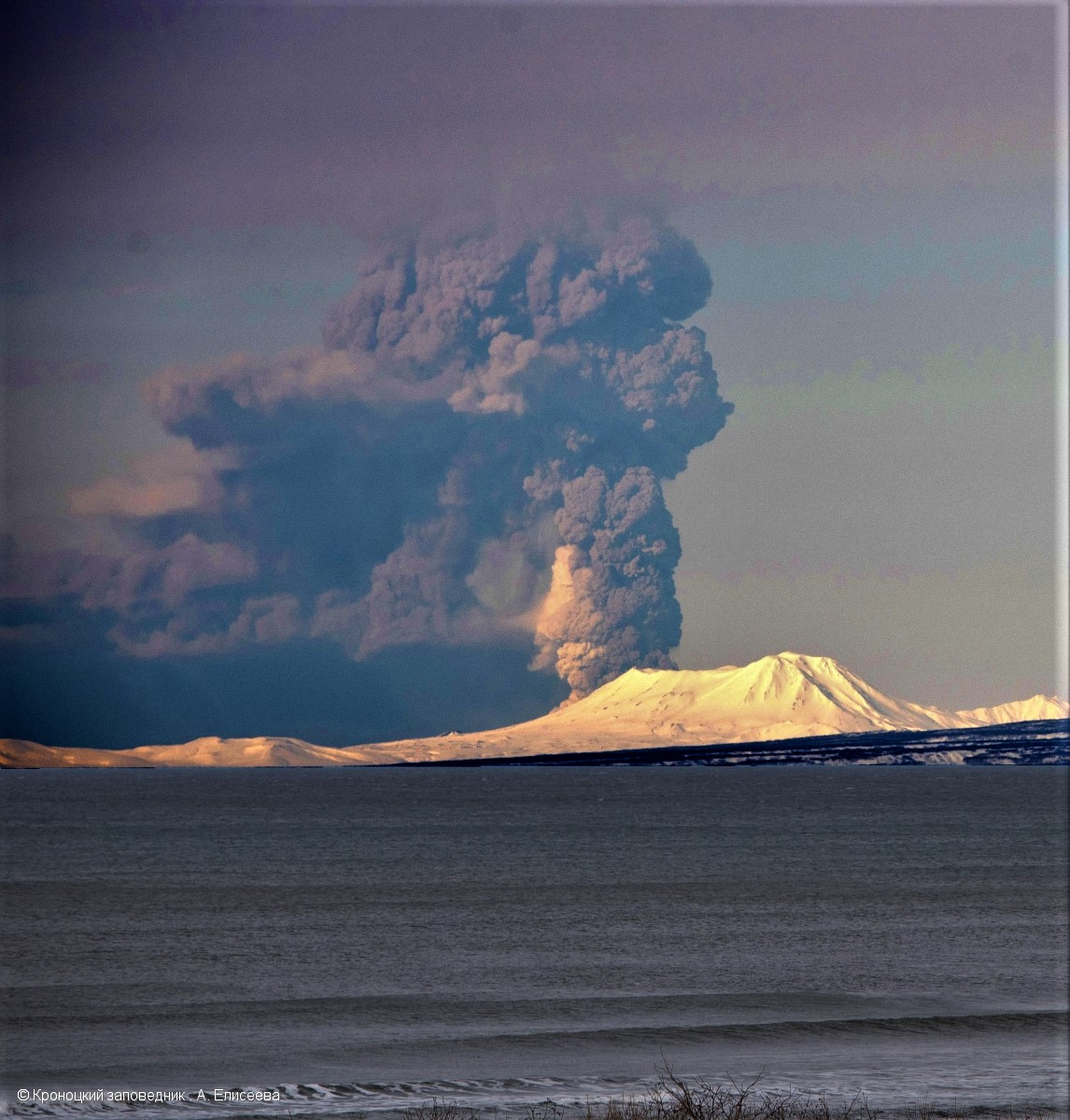
Photo taken from the territory of Olga Bay of Kronotsky Bay, Maly Semyachik Volcano in the foreground.
Volcanic cloud height:
4500-5000 m (14760-16400 ft) AMSL Time and method of ash plume/cloud height determination: 20220420/0300Z – Himawari-8
Other volcanic cloud information:
Distance of ash plume/cloud of the volcano: 45 km (28 mi)
Direction of drift of ash plume/cloud of the volcano: SSE / azimuth 158 deg
Time and method of ash plume/cloud determination: 20220420/0300Z – Himawari-8.
Source : Kvert .
Photo : A. Eliseeva, Kronotsky Reserve ( 19/04/2022)
Italy , Vulcano :
WEEKLY BULLETIN, from April 11, 2022 to April 17, 2022. (issue date April 19, 2022)
ACTIVITY STATUS SUMMARY:
In the light of the surveillance data, it is highlighted:
1) Temperature of the crater fumaroles: The temperatures recorded on the rim of the crater show stable values at high levels
2) CO2 flux in the crater area: The latest measurements attest to high values
3) SO2 flux in the crater area: SO2 flux at a medium-high level
4) Geochemistry of fumarolic gases: The last sampling of March 31 confirmed the downward trend in the concentration of magmatic gases in fumarolic steam
5) CO2 fluxes at the base of the La Fossa cone and in the Vulcano Porto area: The CO2 fluxes recorded in the C. Sicilia and Rimessa sites show values comparable to those recorded last week, and remain at values medium-high, although significantly lower than the period November-December 2021; in the Faraglione site, there are values close to the background level.
6) Geochemistry of thermal aquifers: The temperature measured in the Camping Sicilia well is at high and stable values. The electrical conductivity shows low values.
The level values measured in the Bambara well show a slight increase. Conductivity values remain constant at medium-high levels.
7) Local seismicity: low occurrence rate of local events.
8) Regional seismicity: Moderate fracturing seismicity associated with earthquakes with Ml >= 1.0.
9) Deformations – GNSS: No significant changes to report
10) Deformations – Inclinometry: No significant changes to report
11) Other observations: Gravimetry: No significant change in the short and medium term has been recorded.
Mobile GNSS: No significant changes are visible during the reporting period.

TEMPERATURE OF THE FUMAROLES OF THE CRATER
Along the upper edge, the maximum emission temperature has very stable values (T1: 382-387°C), with a weekly average of 385°C. The fumarole field has equivalent emission temperatures over the entire summit fracture line to confirm a thermal anomaly still maintained by a substantial vapor flow: on April 13, maintenance was carried out with the restoration of detection in Fumarole F5 ( sensor T3). The fumarole showed emission temperatures (T MAX 379; average T 375°C) perfectly superimposable on the temperatures of the T2 sensor placed in F5AT.
The still prohibitive working conditions on site did not allow the technicians to carry out maintenance on the entire network. In addition, we inform you that after only 4 days from the reset, the default signals have reappeared in the F5 fumarole measurement line.
At the VCS measurement site, east of the fumarole field, thermal data indicates an average heat flux of 65 w/m2, above the average background reference of 46 w/m2
CO2 FLOW AT THE BASE OF LA FOSSA CONE AND IN THE VULCANO PORTO AREA
The CO2 fluxes at the base of the crater in the C. Sicilia site show average to high values, above the background level, although in sharp decline compared to the November-December 2021 period; the P4max site shows medium to high values, while continuing to show a slight downward trend; the Remessa site recorded medium-high values, stable compared to last week; in the Faraglione site there are values close to the background level.
Source : INGV.
Photos : INGV.
New Zealand , Ruapehu :
Mt Ruapehu strong volcanic tremor continues. Volcanic Alert Level remains at Level 2. Published: Wed Apr 20 2022 10:15 AM
Aviation Colour Code remains at Yellow
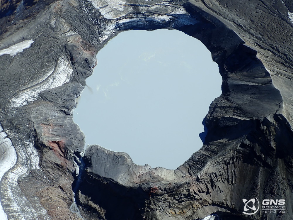
Elevated volcanic unrest continues at Mt Ruapehu, with strong volcanic tremor and the Crater Lake (Te Wai ā-moe) temperature now stabilised at 37°C for the past week. The Volcanic Alert Level remains at Level 2.
Elevated volcanic unrest has been sustained at Mt Ruapehu for four weeks. This heightened unrest is primarily manifested as volcanic tremor and heat flow into the summit crater lake. The tremor levels remain elevated, representing the longest period of tremor recorded over the past 20 years. An observation flight and sampling of the crater lake were performed last week to further assess the activity. Our scientists observed some upwelling in the lake, indicating that hot gas and liquid are still making their way into the lake. The crater lake remains a battleship grey colour with upwellings only at the northern vents area and no overflow. Sulphur slicks are also present on the lake surface. All these characteristics are usual for Ruapehu crater lake during a heating phase.
The Crater Lake (Te Wai ā-moe) temperature is now 37 °C. Our modelling suggests that about ~230 MW of heat is required to sustain this high lake temperature. Temperature and heat input remain within the typical range for a heating cycle. Over the past 30 days, the lake temperature increased by 7°C, which is like previous heating phases. But the heating has slowed down and temperatures have now been steady around 37 °C for the last week. This slowing of the heating, in spite of the ongoing strong level of volcanic tremor continues to indicate heightened volcanic unrest as pressure could be building up at depth.
The sustained nature of the volcanic unrest, coupled with the volcanic tremor signals, elevated gas output and hot lake remain indicative of processes being driven by molten rock (magma) interacting with the geothermal system within the volcano.
The order of the potential outcomes has not changed since last week. The most likely outcome of this unrest episode within the next four weeks is still that no eruptive activity occurs, as no eruptions have followed unrest in the past 15 years. However, there is also a possibility of a single or multiple eruptions that could impact the summit area and generate lahars into some catchments draining off the volcano, especially the Whangaehu Valley. The size of these eruptions, if they did occur, would probably be like that of September 2007, or the slightly larger April 1975 or June 1969 events.
The chances of a prolonged and larger eruption, such as occurred in 1995-96 with wider ashfall impacts, is higher than it was two months ago, but remains very unlikely. Such an eruption would most likely only follow a sequence of smaller eruptions.
The interpretation of this activity is consistent with elevated volcanic unrest at the heightened level and therefore the Volcanic Alert Level remains at Level 2. The Aviation Colour Code remains at Yellow.
Mt Ruapehu is an active volcano and has the potential to erupt with little or no warning when in a state of elevated volcanic unrest.
The Volcanic Alert Level reflects the current level of elevated volcanic unrest. The Volcanic Alert Level should not be used to forecast future activity. However, at Volcanic Alert Level 2, eruptions are usually more likely than at Volcanic Alert Level 1.
Source : Geonet / Agnès Mazot / Duty Volcanologist .
Photo : GNS Sciences
Colombia , Puracé :
Weekly bulletin of the activity of the Puracé volcano – Los Coconucos volcanic chain
The activity level of the volcano continues at the Yellow Activity Level or (III): changes in the behavior of volcanic activity.
From the analysis and evaluation of the information obtained through the monitoring network of the Puracé volcano – Los Coconucos volcanic chain, during the week of April 12 to 18, 2022, the COLOMBIAN GEOLOGICAL SERVICE – Volcanological and Seismological Observatory of Popayan reports that:
• During the evaluated period, 369 seismic events were recorded, of which 102 were related to rock fracturing processes (type VT) and 267 to fluid dynamics.
in volcanic conduits. Of these, 231 were classified as long period events (LP type), 32 as low energy tremor pulses (TR type), two (2) as « Tornillos » type events (TO type) and two (2) as hybrid events (type H-B).
• The geodetic network for measuring the deformation of the volcanic soil, as well as the processing of satellite images, continue to record a process associated with an inflation of the millimeter order.
• Measurements of sulfur dioxide (SO2) emissions continued, reporting a maximum value of 2,389 t/day for this week.
Therefore, it is concluded that a significant increase in volcanic activity continues to be recorded, in accordance with the behavior expected at activity level III (yellow level), which could evolve towards states of greater activity. The Colombian Geological Service continues to monitor the evolution of the volcanic phenomenon and will report any changes that may occur in due course.
Source et photo : SGC.
Iceland , Reykjanes Peninsula :
Roughly 1500 earthquakes were detected by the IMO¿s SIL-seismic network last week, considerably more than in the previus week. Around 850 earthquakes have been manually reviewed by the natural hazard specialist on duty at the IMO during the past week. Earthquakes that have not yet been reviewed are mostly located in the Reykjanes peninsula where an earthquake swarm started on the 17th of April.
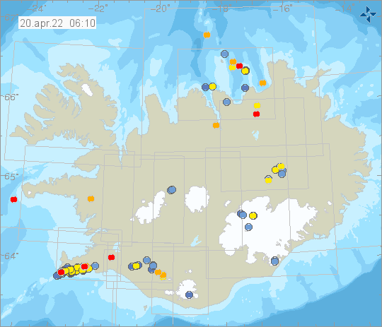
Nine earthquakes above M3 occurred in the past week, the largest earthquake was of M3.9 just 6 km NE of Reykjanestá. In that area six earthquakes over M3 occurred. The orther three earthquakes above M3 occurred just 7 km VSV of Reykjanestá. On the 11th of April a small earthquake swarm started about 8 km NV of Hveravellir, about 60 earthquakes were located in that area. Other activity was distributed around the country.
Source et photo : Vedur is