April 05 , 2022 .
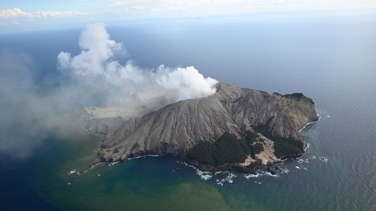
New Zealand , White Island :
Whakaari/White Island: Volcanic Alert Level lowered to Level 1, minor volcanic unrest continues
Published: Mon Apr 4 2022 3:15 PM
Volcanic Alert Level is lowered to 1
Aviation Colour Code is lowered to Green
Observations and monitoring data over the past two months at Whakaari/White Island have been progressively trending back to lower levels of unrest that are typical of the long-term behaviour for the volcano. The decision to lower the Volcanic Alert Level to Level 1 is not based on changes in a single data set, but on the GNS Science Volcano Monitoring Group’s collective interpretation of all the monitoring data and their trends over the past two months. The data sets considered in our interpretation include observations from observation flights, web cameras, gas data, vent temperatures, ground deformation, and seismic activity.
The temperature of the emitted gas and steam remains elevated, but has declined to below 300 °C. Discharge rates of sulphur dioxide (SO2), hydrogen sulphide (H2S) and carbon dioxide (CO2) gases are at, or below, longer-term trends, as are ground deformation and seismic activity. Minor or dilute ash emission has not been observed since late February 2022.
Taken together, these observations and the downward trends of key data sets over the past two months are consistent with low levels of unrest. As such the Volcanic Alert Level is lowered to Level 1 and the Aviation Colour Code is changed to Green.
The Volcanic Alert Level reflects the current level of volcanic unrest or activity and is not a forecast of future activity. Volcanic Alert Level 1 indicates the primary hazards are those expected during volcanic unrest; steam discharge, volcanic gas, earthquakes, landslides and hydrothermal activity. While Volcano Alert Level 1 is mostly associated with environmental hazards, potential for eruption hazards also exists and eruptions can still occur with little or no warning.
Source : Geonet / Yannik Behr / Duty volcanologist.
Photo : Rotorua Daily Post.
Iceland , Reykjanes Péninsula :
Earthquake swarm north of Grindavík town
Around 14:00 UTC an earthquake swarm started north of Grindavík town. This look like a tension breaking earthquake swarm and that suggests an inflation is happening again in Fagradalsfjall volcano (mountain). Largest earthquake so far had a magnitude of Mw3,3 and second largest earthquake so far had a magnitude of Mw3,0.
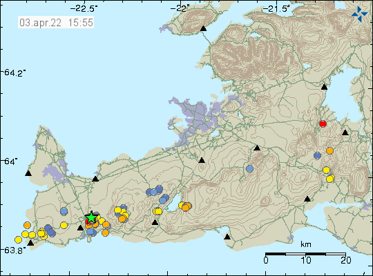
Green star on the map north of Grindavík town shows the main earthquake swarm
This earthquake swarm is ongoing, but like with all earthquakes swarms in this area it shows a sign of slowing down for few hours before continuing. There is a chance this earthquake swarm might be over.
At 13:44 yesterday an earthquake swarm started 5 km NNE of Grindavík when an M2.9 earthquake occurred. M3.0 and M3.3 earthquakes occurred shortly after 14:00. Around 180 earthquakes have been detected since the swarm started. Earthquake swarms occur frequently in this area and there are about two weeks since the last swarm took place. Then around 170 earthquakes were detected in one day, all below M3.0. Last M3.0 earthquake occurred in the area on 14th of February.
Sources et photo : Icelandgeology.net , Met Office islandais.
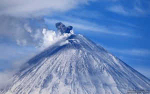
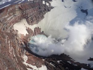
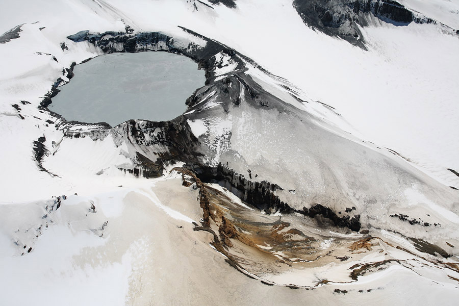
New Zealand , Ruapehu :
Mt Ruapehu volcanic tremor and Crater Lake heating continues. Volcanic Alert Level remains at Level 2. Published: Tue Apr 5 2022 3:20 PM
Volcanic Alert Level remains at 2
Aviation Colour Code remains at Yellow
Over the past eight days, the temperature at Mt Ruapehu’s Crater Lake (Te Wai ā-moe) has risen further from ~32 °C to ~36 °C. Our modelling suggests that the temperature rise corresponds to about ~460 MW of heat entering the lake. Temperature and heat input are within the typical range for a heating cycle.
Volcanic tremor levels remain elevated and, after a slight increase over the past week, are now amongst the highest levels we have seen over the past nine years.
Crater Lake water and gas sampling and an airborne gas flight were completed last week. Analysis of the lake water and gas samples do not indicate significant changes in the geothermal system feeding into the lake. The amount of gas released through the lake has increased from the previous measurements but remains within the typically observed long term trends. The crater lake has changed to a battleship grey colour as upwelling waters have disturbed sediments on the lake floor. Sulphur slicks are present on the lake surface.
The results to date are typical for the beginning of a heating cycle with the exception that tremor values are unusually high. Current data indicate that normal processes seen at the crater lake are occurring. Gas and fluids from the shallow magma under the volcano are interacting with the crater lake geothermal system, causing heating of the lake, volcanic tremor, and increases in gas emission at the surface.
The interpretation of this activity is consistent with elevated volcanic unrest and therefore the Volcanic Alert Level remains at Level 2. The Aviation Colour Code remains at Yellow.
Mt Ruapehu is an active volcano and has the potential to erupt with little or no warning when in a state of elevated volcanic unrest.
The Volcanic Alert Level reflects the current level of elevated volcanic unrest. The Volcanic Alert Level should not be used to forecast future activity. However, at Volcanic Alert Level 2, eruptions are usually more likely than at Volcanic Alert Level 1.
Source : Geonet / Yannik Behr / Duty volcanologist.
Photo : Photovolcanica .
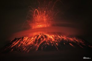
Peru , Sabancaya :
Analysis period: from March 28, 2022 to April 03, 2022, Arequipa, April 04, 2022.
Alert level: ORANGE
The Geophysical Institute of Peru (IGP) reports that the eruptive activity of the Sabancaya volcano remains at moderate levels, that is to say with the recording of an average of 41 daily explosions, with columns of ash and of gas up to 2.0 km altitude above the summit of the volcano and their subsequent dispersion. Therefore, for the following days, no significant change is expected in eruptive activity.
The IGP recorded and analyzed the occurrence of 205 earthquakes of volcanic origin, associated with the circulation of magmatic fluids inside the Sabancaya volcano. An average of 41 explosions was recorded daily, in addition to recording Volcano-Tectonic (VT) type events associated with rock fracturing inside the Sabancaya volcano.
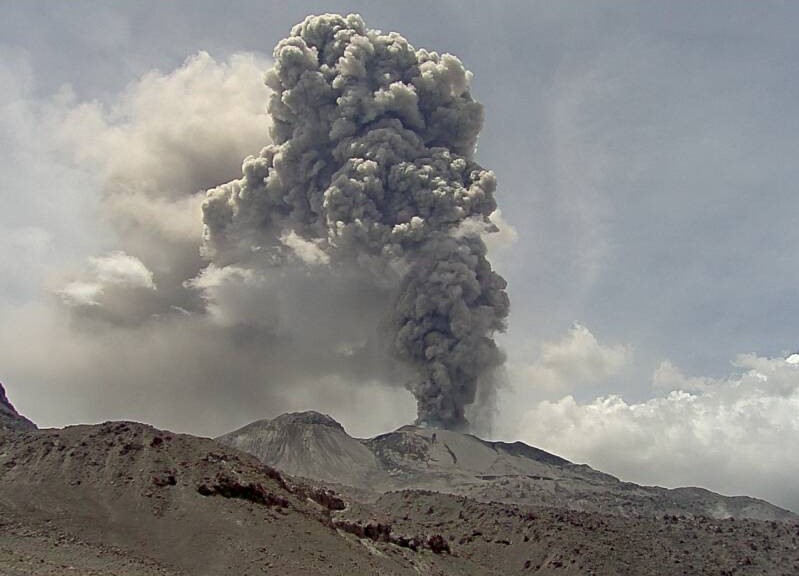
Monitoring the deformation of the volcanic structure using GNSS techniques (processed with fast orbits) does not show any significant anomalies. However, in general, an inflation process has been observed in the northern sector (surroundings of the Hualca Hualca volcano). Visual surveillance identified columns of gas and ash up to 2.0 km a.s.l. above the summit of the volcano, which were dispersed towards the West, South-West, South, South-East and East of Sabancaya. Satellite recordings identified the presence of 2 thermal anomalies, with a maximum value of 11hvo ha MW, associated with the presence of a lava body on the surface of the volcano’s crater.
RECOMMENDATIONS
• Keep the volcanic alert level orange.
• Do not approach within a radius of less than 12 km from the crater.
Source : CENVUL
Photo : Ingemmet 2017.
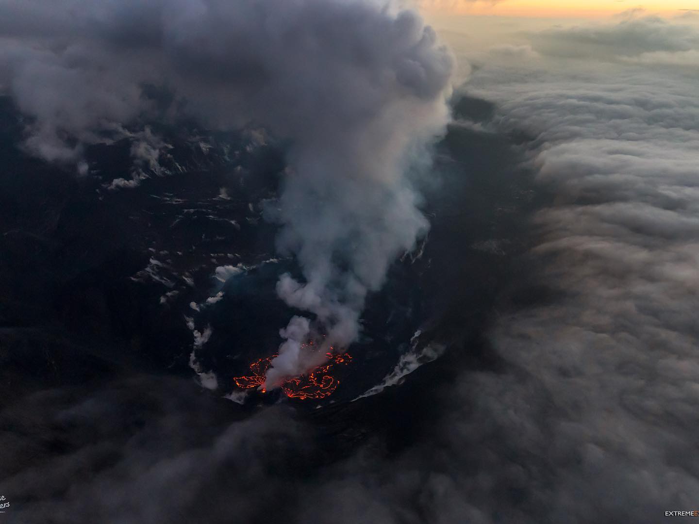
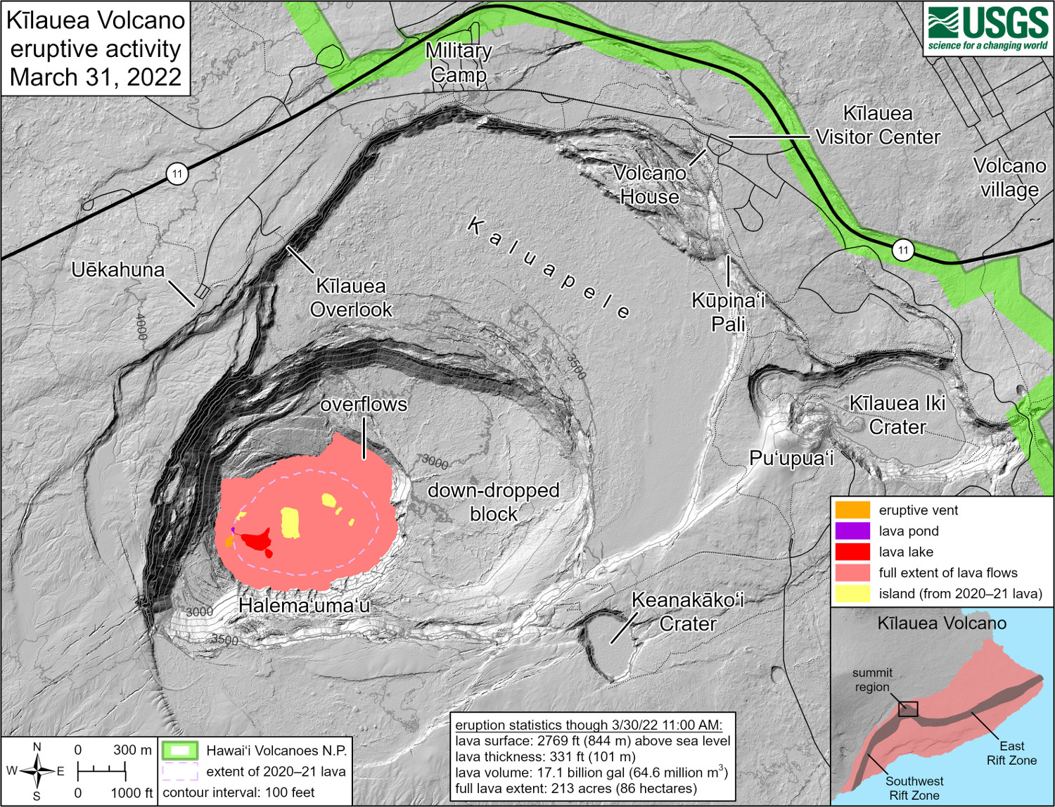
Hawaii , Kilauea :
19°25’16 » N 155°17’13 » W,
Summit Elevation 4091 ft (1247 m)
Current Volcano Alert Level: WATCH
Current Aviation Color Code: ORANGE
Activity Summary:
The summit eruption of Kīlauea Volcano, within Halemaʻumaʻu crater, continued over the past 24 hours. All recent activity has been confined to the crater, and there are no indications of activity migrating elsewhere on Kīlauea.
Halemaʻumaʻu crater Lava Lake Observations:
Eruption of lava from the western vent into the active lava lake (approximately 2.3% of the crater floor surface) and onto the crater floor continued over the past 24 hours. Occasional ooze outs along the eastern half of the crater floor occurred, and crustal overturning was minimal on the northwest margin. The lava level is steady. Since the beginning of this eruption on September 29, 2021, the crater floor has seen a total rise of about 96 meters (315 feet). The volume of lava effused since the beginning of this eruption was approximately 64 million cubic meters (84 million cubic yards or 17 billion gallons) as measured on March 29, 2022.
Summit Observations:
Summit tilt flattened early yesterday morning and has had a slight inflationary trend over the past 24 hrs. Volcanic tremor remains above background levels. A sulfur dioxide (SO2) emission rate of approximately 3,100 tonnes per day (t/d) was measured on March 31, 2022.
Source : HVO.
Photos : Bruce Omori / Paradise Hélicopters. USGS.