March 23 , 2022 .
New Zealand , White Island :
Whakaari/White Island: Volcanic unrest continues with some crater changes. Published: Wed Mar 23 2022 2:00 PM
Volcanic Alert Level remains at 2
Aviation Colour Code remains at Yellow
Recent observation and gas measurement flights confirm that dilute ash emission has currently ceased. Subsidence has occurred within the 2019 Primary Crater. The Volcanic Alert Level remains at Level 2.
Last week GNS volcanologists undertook observation and gas measuring flights over the island. In the time between the two flights a small collapse occurred in one of the craters, active in 2019. No further ash emission was observed.
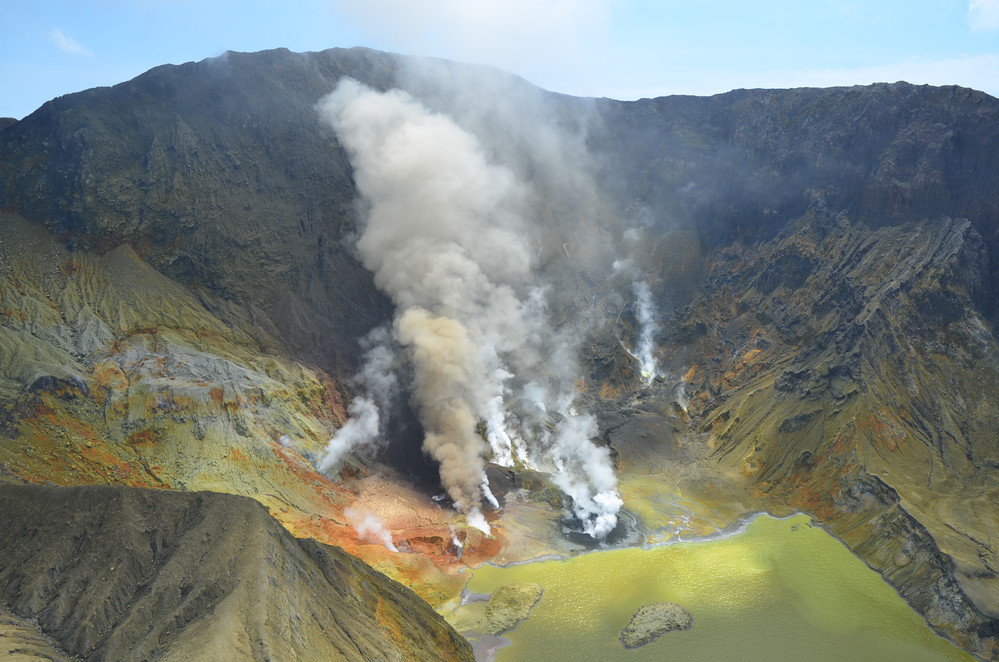
During the gas measuring flight geysering was observed from a small grey coloured pool on the south side of the 2019 Primary Crater. A little over an hour later during an observation flight, the pool was gone, and a collapse pit was present. The observation flight also established a larger collapse structure was present in the crater, but it is not clear exactly when this occurred. The formation of collapse craters at Whakaari/White Island was common in the past and was thought to be caused by either withdrawal of liquid beneath the crater or the removal of fine-grained ash during recent ash emissions. While this collapse activity poses no immediate hazard, it shows that the shallow crater environment remains dynamic and is changing in response to pressure variations beneath the active craters. This is a sign of continuing unrest.
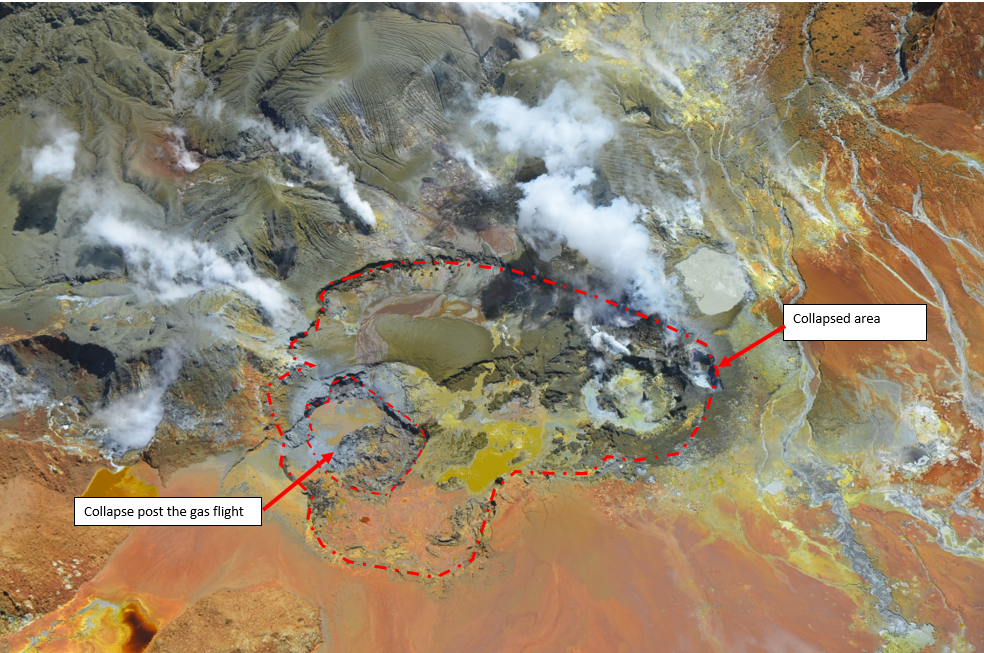
Aerial view of the active vents at Whakaari/White Island showing the areas of collapse (red dashed line). Bright colours are hydrothermal minerals precipitated on the ground.
Gas emissions have declined since the last measurements and vent temperatures are also lower at around 290 C. The water level in the lake has receded slightly in the past few weeks. Volcanic tremor remains low.
The current level of activity is consistent with moderate to heightened levels of unrest. As such the Volcanic Alert Level remains at 2 and the Aviation Colour Code remains at Yellow.
As noted previously, our on-island equipment has degraded over the past two years. However, recent improvements of the transmission of data means that some of the data is more continuous and more complete than it has been recently.
Source et photo : Geonet / Craig Miller / Duty Volcanologist
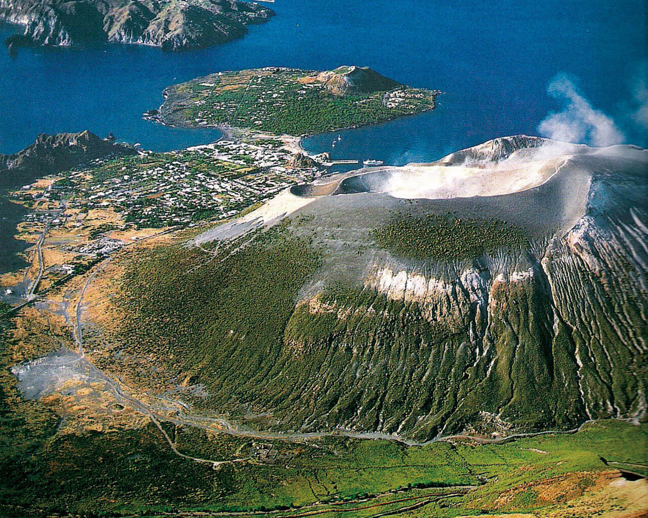
Italy , Vulcano :
WEEKLY BULLETIN, from March 14, 2022 to March 20, 2022. (issue date March 22, 2022)
ACTIVITY STATUS SUMMARY
In the light of the surveillance data, it is highlighted:
1) Temperature of the crater fumaroles: The updated data of the temperatures recorded on the edge of the crater show stable values.
2) CO2 flux in the crater area: The CO2 flux in the crater area remains at high values.
3) SO2 flux in the crater area: SO2 flux at a medium-high level
4) Geochemistry of fumarolic gases: No update is available.
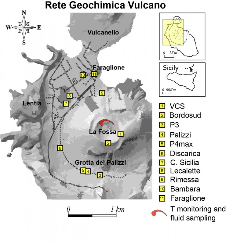
5) CO2 fluxes at the base of the La Fossa cone and in the Vulcano Porto area: The CO2 fluxes recorded in the Rimessa, C. Sicilia and P4max sites show a slight downward trend, but remain at medium-high values; in the Faraglione site, there are values close to the background level.
6) Geochemistry of thermal aquifers: The physicochemical parameters recorded in the Camping Sicilia well show modest decreases in temperature and salinity, while in the Bambara well there is a stabilization of the piezometric level and a slight decrease in salinity .
7) Local seismicity: low occurrence rate of local events.
8) Regional seismicity: No earthquake with Ml >= 1.0 was located in the area of the island of Vulcano.
9) Deformations – GNSS: The network of permanent GNSS stations has not recorded any significant changes.
10) Deformations – Inclinometry: The inclinometric network has not recorded any significant changes
11) Other observations: Gravimetry: During the period considered, no significant variation was recorded.
GB-RAR: The GB-RAR monitoring results referring to the period December 14, 2021 – March 21, 2022, show a general stability of the area, with deformations along the LOS of less than 1 mm.
CRATER FUMAROLES TEMPERATURE:
The reference sensor for the maximum temperature has very stable values, with a weekly average of 384°C. The sensor placed in the fumarole on the inner side did not exceed 104°C, but the data is not stable and indicates that this measurement line requires maintenance.
CO2 FLOW IN THE CRATER AREA
The ground CO2 flux values in the summit area in daily average (VCSCS) show high values around 14293 g/m2/day (March 17, 2022), still more than an order of magnitude higher than the averages recorded during of the last 10 years. The average monthly value of CO2 flux for the month of March 2022 is 12100 g/m2/day.
CO2 FLOW AT THE BASE OF THE CONE DE LA FOSSA AND IN THE VULCANO PORTO AREA:
The CO2 fluxes at the base of the crater in the Rimessa, C. Sicilia and P4max sites, although showing a slight downward trend, remain at medium-high values; in the Faraglione site, there are values close to the background level.
Source : INGV.
Photo : voyages-lesiles.ch.
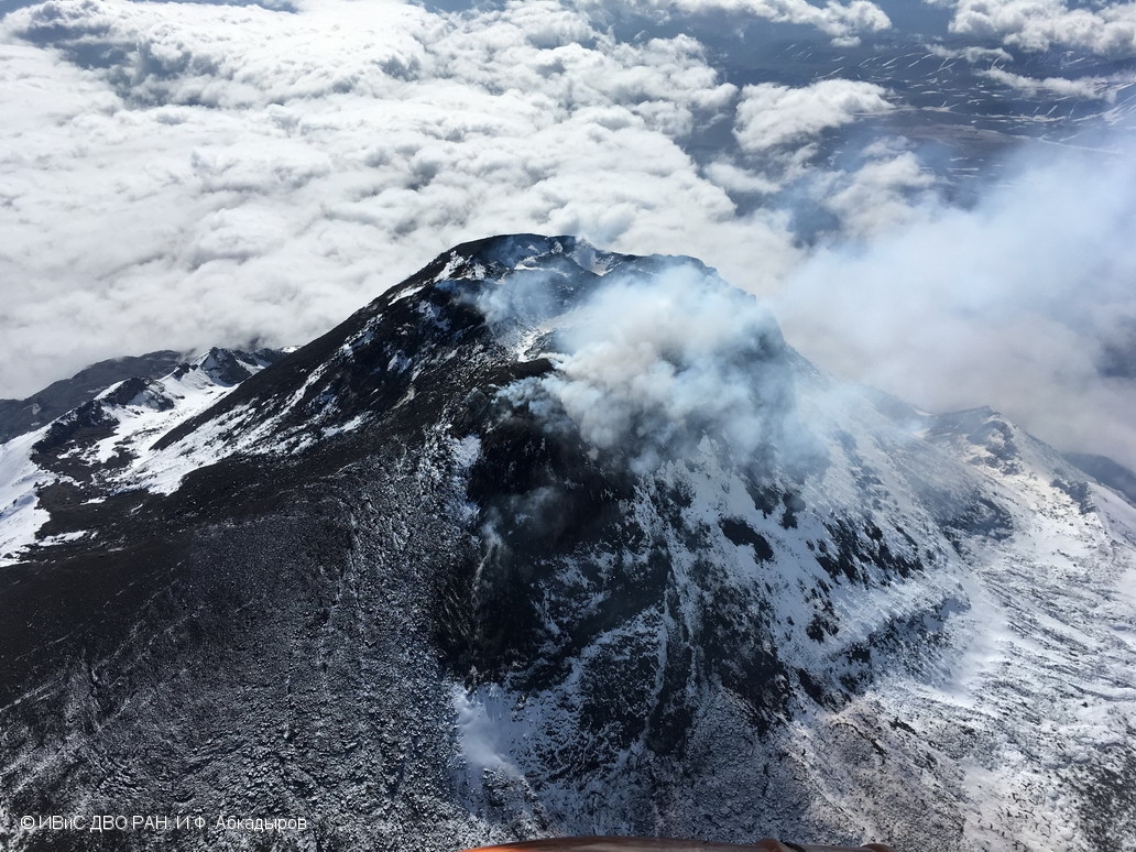
Kamchatka , Bezymianny :
VOLCANO OBSERVATORY NOTICE FOR AVIATION (VONA)
Issued: March 23 , 2022
Volcano: Bezymianny (CAVW #300250)
Current aviation colour code: YELLOW
Previous aviation colour code: orange
Source: KVERT
Notice Number: 2022-21
Volcano Location: N 55 deg 58 min E 160 deg 35 min
Area: Kamchatka, Russia
Summit Elevation: 2882 m (9452.96 ft)
Volcanic Activity Summary:
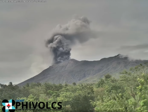
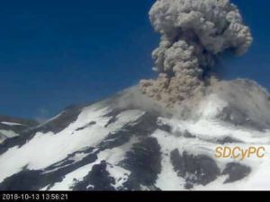
After the strong explosive eruption on 14-15 March, a growth of the lava dome continues, a strong fumarole activity and hot avalanches accompanies this process. Satellite data by KVERT show a thermal anomaly over the volcano.
A moderate gas-steam activity of the volcano continues. Ongoing activity could affect low-flying aircraft.
Volcanic cloud height:
NO ASH CLOUD PRODUSED
Other volcanic cloud information:
NO ASH CLOUD PRODUSED
Source : Kvert.
Photo : I.F. Abkadyrov, IVS FEB RAS.
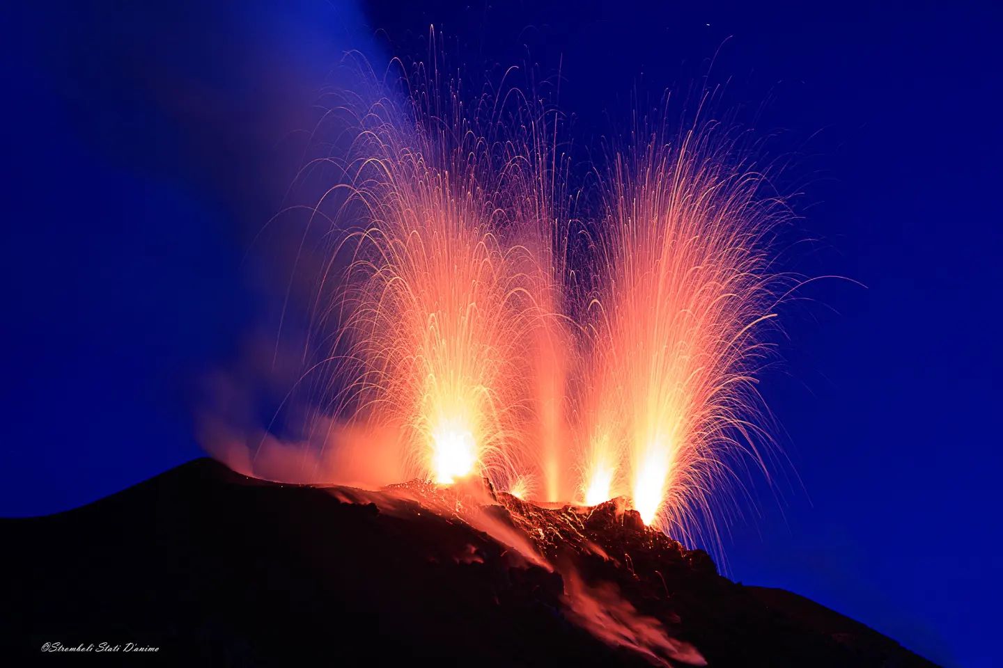
Italy , Stromboli :
WEEKLY BULLETIN, from March 14, 2022 to March 20, 2022. (issue date March 22, 2022)
ACTIVITY STATUS SUMMARY:
In the light of the surveillance data, it is highlighted:
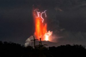
1) VOLCANOLOGICAL OBSERVATIONS: During this period, normal explosive activity of the Strombolian type was observed with projection activity in the N zone. The total hourly frequency of explosions fluctuated between average values (11 events/h) and average values – high (18 events/h). The intensity of the explosions was mainly medium and low in the area of the North crater and low in the area of the Center-South crater.
2) SEISMOLOGY: The seismological parameters monitored do not show any significant variations.
3) SOIL DEFORMATIONS: The island’s soil deformation monitoring networks did not show any significant changes to report for the period under review.

4) GEOCHEMISTRY: SO2 flux at an average level.
CO2 fluxes in the crater area remain at high values.
Due to technical issues, there are no updates on the C/S ratio in the plume.
There are no updates on the isotope ratio of helium in groundwater.
5) SATELLITE OBSERVATIONS: The thermal activity observed by satellite was at a low level.
VOLCANOLOGICAL OBSERVATIONS
During the observation period, the eruptive activity of Stromboli was characterized through the analysis of images recorded by the INGV-OE surveillance cameras (altitude 190m, Punta Corvi, altitude 400m and Pizzo). The explosive activity was mainly produced by 5 (five) eruptive vents located in the North crater area and 2 (two) eruptive vents located in the Center-South crater area. All the mouths are placed inside the depression which occupies the terrace of the crater (Fig. 3.1).
Due to unfavorable weather conditions, the visibility of the crater terrace during the day of March 19, 2022 was not sufficient for a correct description of the eruptive activity.
Sector N1 located in the area of the North crater produced explosions of variable intensity from low (less than 80 m high) to medium (less than 150 m high) emitting coarse materials (lapilli and bombs). Sector N2, with four emission points, showed low to medium intensity explosive activity (less than 120 m high) emitting coarse material with intense spattering activity for short intervals between 16 days and March 17. The average frequency of explosions varied from 5 to 14 events/h.
In the Center-South zone, sectors C and S1 did not show significant explosive activity. Sector S2, with two emission points, had low intensity explosions (the products of the explosions did not exceed 80 m in height) emitting coarse materials. The frequency of the explosions varied between 4 and 8 events/h.
Source : INGV.
Photo : Stromboli stati d’animo.
Azores , São Jorge :
70 earthquakes were recorded in just 24 hours on the island of São Jorge. OVGA News March 21, 2022.
The Azores Volcanic Earthquake Information and Monitoring Center is monitoring seismic activity, which has increased significantly since 5:00 p.m. Saturday.
In a briefing note, the SRPCBA said the Azores Seismo-Volcanic Information and Monitoring Center (CIVISA) is monitoring seismic activity in São Jorge, which has recorded a significant increase since 5:00 p.m. yesterday.
« The SRPCBA has contacted the mayors and fire departments of Velas and Calheta to remain vigilant and assist the local population in any way necessary, » the statement said.

The Civil Protection of the Azores has already requested, however, from the Operational Command of the Azores, the support of the Armed Forces for the use of an Air Force C-295 aircraft, to transport a team of technicians from Civisa on the island of São Jorge, in order to assess the situation on the ground.
« In case of need and through the conclusions of the analysis that is carried out by CIVISA technicians, the SRPCBA has prepared a team with elements of this service and with telecommunications equipment to be designed for São Jorge », also indicates the same statement.
Despite the appearance of dozens of low-magnitude earthquakes (only ten were felt at 2 p.m. local time), Civil Protection calls on the population of São Jorge Island to remain calm and follow the information and recommendations released by the authorities.
Earthquakes felt on the island of São Jorge
The Azores Seismo-Volcanic Information and Monitoring Center (CIVISA) reports that at 7:54 p.m. and 8:07 p.m. (local time = UTC-1 time), March 22, 2 events were recorded. The 7:54 p.m. earthquake had a magnitude of 2.1 (Richter) and had an epicenter about 1 km north-northeast of Velas, on the island of São Jorge. The 8:07 p.m. event had a magnitude of 2.2 and an epicenter 1 km north-northeast of Santo Amaro, São Jorge Island.
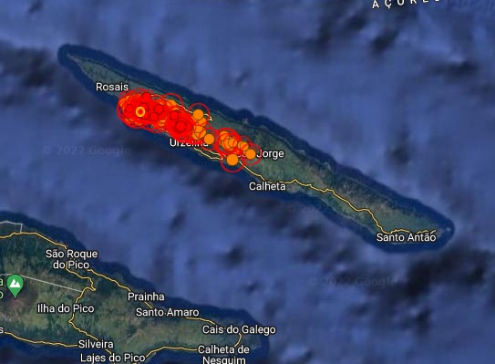
According to the information available to date, the 7:54 p.m. earthquake was felt with maximum intensity III/IV (modified Mercalli scale) in the municipality of Velas. The 8:07 p.m. earthquake was felt with maximum intensity III/IV in the municipality of Velas, São Jorge Island.
CIVISA continues to monitor the situation.
Source : OVGA, Civisa .
Photo : José Luís Ávila Silveira/Pedro Noronha de Costa