October 14 , 2018.
Guatemala , Fuego :
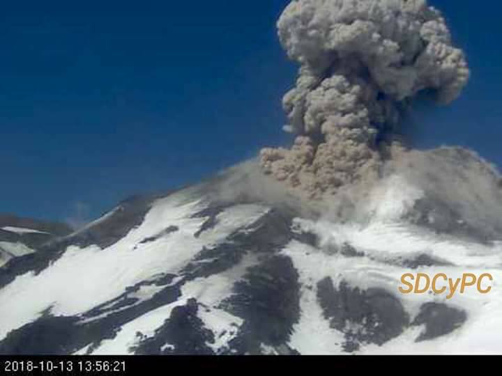
BEFGO SPECIAL VULCANOLOGICAL BULLETIN # 180-2018 EFFUTIVE ERUPTION, Guatemala October 13, 2018 at 00:00 hours (local time).
Type of activity: Vulcanian
Morphology: Composite Stratovolcano
Location: 14 ° 28’54˝Latitude N; 90 ° 52’54˝Longitude W.
Altitude: 3,763msnm.
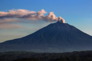
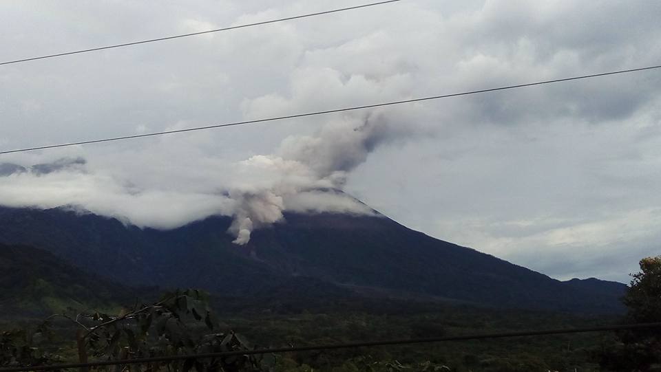
The effusive activity of the Fuego volcano maintains a lava flow 1,500 m in length to the west, which descends into the Seca ravine. The ashes are raised due to the advance of the flos, as well as due to avalanches due to the movement of the flow.
https://www.facebook.com/myfckworldtour2018/videos/2176146839308534/
The eruptive dynamics is maintained with moderate explosions that emit ash columns at an altitude of 5,000 m above sea level and are scattered 15 to 20 km to the southwest, west and southeast. Low to moderate sounds similar to those of a train locomotive are heard. Incandescent pulses are observed 200-300 m above the crater with moderate avalanches on the crater contour. Ash particles fall back into the areas of Panimache I, Morelia, Santa Sofia, Sangre de Cristo, El Porvenir, Finca Palo Verde and others
In the afternoon of the 12th, pyroclastic flows descended into the Seca Canyon. It is therefore possible that pyroclastic flows occur in the following hours and are descended into the ravines of the Fuego volcano, so you must be alert to these sudden changes.
Precipitation during the afternoon in the Fuego Volcano region generated strong lahars in the Ceniza Canyon, a tributary of the Achiguate River, and moderate in the Seca, Mineral River, and Taniluyá gullies, two tributaries of the Pantaleón river.
These lahars have the characteristic of transporting pasty materials, with blocks from two centimeters to two meters in diameter, branches and tree trunks. Some go down hot, which raises columns of steam.
The institute requested that Conrad implement the state of alert it deems necessary due to this new phase of the eruption.
Guatemala’s Fuego volcano erupted near the capital Friday effecting a pyroclastic flow and subsequent evacuations, spokesman for the state Coordinator for Disaster Reduction (Conrad), David de Leon, said.
“The activity of the Fuego volcano is maintained with constant explosions and a column of ash at a height of 5,000 meters above sea level that is dispersed from 15 to 20 kilometers to the southwest, west and southeast.”
Several families consisting about 62 people in total were removed from the affected regions before the fall of ash and lava flow. Evacuations took place in Sangre de Cristo and the Palo Verde.
According to an Institute of Volcanology bulletin, the volcano maintains an igneous area of 400 meters above the crater accompanied by increased reverberations and loud sounds that has generated a lava flow of 600 meters in length to the west of the volcano.
Source : Insivumeh, Conred .
Video : Myfckworldtour2018 via Sherine France
La Réunion , Piton de la Fournaise :
Activity bulletin from Saturday, October 13, 2018 at 14:30 (local time).
The eruption started on September 15th at 4:25 am local time continues. The intensity of the volcanic tremor (indicator of surface eruptive intensity) is still slightly decreasing (Figure 1).
Piston gases (« gas flushes » or « tremor puffs ») at the eruptive site are always recorded by the OVPF seismometers.
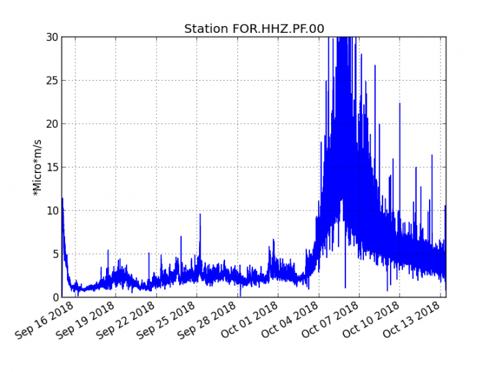
Figure 1: Evolution of the RSAM (indicator of the volcanic tremor and the intensity of the eruption) between 04h00 (00h UTC) on September 15th and 14h00 (10h00 UTC) on October 13th on the FOR seismic station, located near the crater Chateau Fort (2000 m altitude on the southeast flank of the terminal cone). (© OVPF / IPGP)
– No volcano-tectonic earthquake was recorded during the day of 12 October, nor during the current day.
– Inflation (swelling) of the building is still recorded even if it seems to have slowed down for three days. This inflation reflects the pressurization of a localized source beneath the summit craters (Bory-Dolomieu) at a depth of 1-1.5 km, related to the recharge of the superficial reservoir by deeper magma.
– The surface flows could not be estimated today because of lava flows that are too weak at the surface and the cloud cover present on site.
– The observations made last night from the observatory’s webcams (aiming in particular at the base of the Nez Coupé du Tremblet), during a gap in the cloud cover, showed that the flow front did not seem to have progressed significantly since the last observations of 08 October (before the deterioration of weather conditions on site) and was maintained at the top of the Grandes Pentes.
– If the weather conditions allow a reconnaissance and a sampling of lava at the front of flow is expected tomorrow Sunday by a team of the OVPF.
Alert level: Alert 2-2 – Eruption in the Enclos .
Source : OVPF . http://www.ipgp.fr/fr/ovpf/bulletin-dactivite-samedi-13-octobre-2018-a-14h30-heure-locale
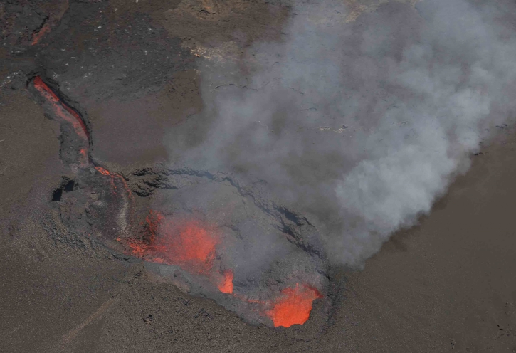
Chile , Nevados de Chillan :
Region del Bio Bio, Volcan Nevados de Chillan, 13 October 2018, 11:40 local time (continental Chile).
The National Geological and Mining Service of Chile (Sernageomin) publishes the following PRELIMINARY information, obtained from monitoring equipment of the National Volcanic Monitoring Network (NVRN), processed and analyzed at the Volcanological Observatory of the Southern Andes (OVDAS) :
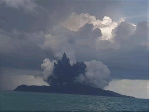
Yesterday, October 13, 2018 at 10:56 local time (13:56 UTC), the monitoring stations installed near the Nevados volcano of Chillan recorded an earthquake associated with the dynamics of the fluids inside the volcanic ducts (long period type) associated with an explosive event.
The characteristics of the earthquake after its analysis are as follows:
TIME OF ORIGIN: 10h56 Local time (13h56 UTC)
LATITUDE: 36,866 ° S
LONGITUDE: 71.376 ° W
DEPTH: 0.7 KM
REDUCED DISPLACEMENT: 1024 cm2
ACOUSTIC SIGNAL: 33.1 Pa reduced to 1 KM
OBSERVATIONS:
The earthquake associated with the explosion was recorded with a seismic signal having a significantly reduced displacement value (seismic energy). From the IP camera installed by the OVDAS, it was possible to observe a column of approximately 1.4 km high, with important hot particulate material falling over the vicinity of the active crater and nearby areas. A posteriori, no other abnormal signals were recorded.
The level of volcanic technical alert remains at the level: ORANGE.
Sernageomin continues online monitoring and will inform in a timely manner about any changes observed.
Source :Sernageomin
Photo : FM del Lago SMAndes 102.5Mhz
Hawai , Kilauea :
19°25’16 » N 155°17’13 » W,
Summit Elevation 4091 ft (1247 m)
Current Volcano Alert Level: ADVISORY
Current Aviation Color Code: YELLOW
Activity Summary:
Kilauea Volcano is not erupting. Rates of seismicity, deformation, and sulfur dioxide gas emissions are low and have not changed significantly in the past Week.
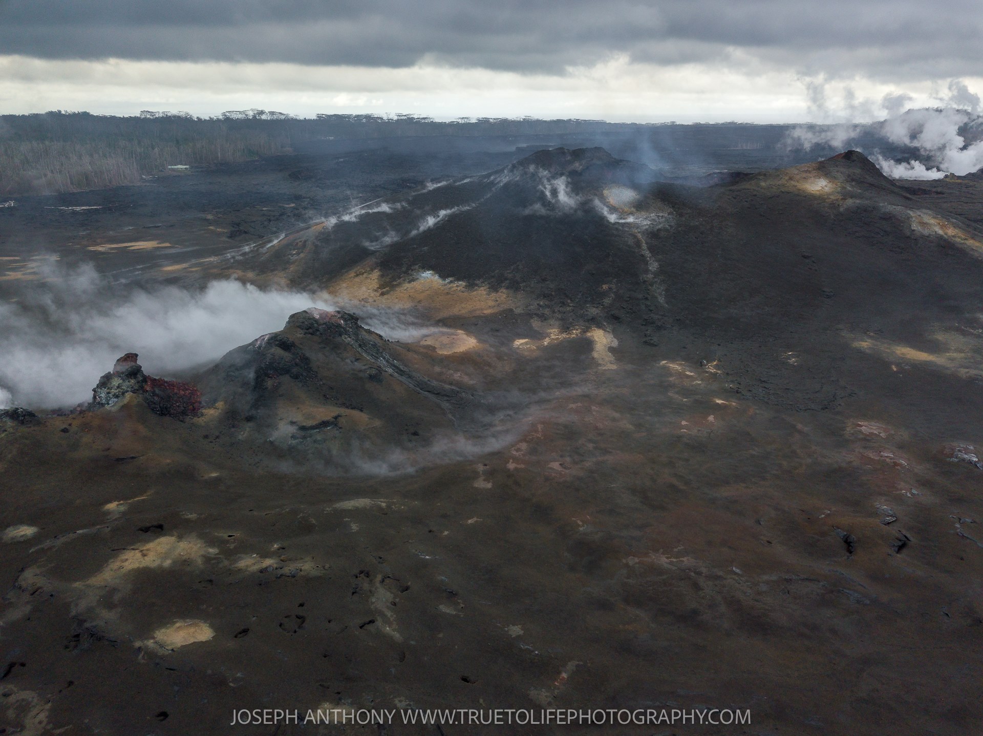
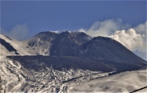
A look at the back of Fissure 8 and the Fissure 8 vents behind the cinder cone still steaming heavily.
Observations:
HVO monitoring during the past week shows low rates of seismicity, deformation, and gas emission at the summit and East Rift Zone (ERZ). Earthquakes continue to occur primarily at Kīlauea’s summit area (magnitude-2.4 was the largest) and south flank with continued small aftershocks of the magnitude-6.9 quake on May 4, 2018. Seismicity remains low in the lower ERZ.
In the ERZ, tiltmeters near Puʻu ʻŌʻō and farther east have recorded a slight inflationary trend in the past few weeks. At the summit, tiltmeters have recorded a slight deflationary trend. Both trends suggest some magma may still be moving into the ERZ from the summit magma reservoir system.
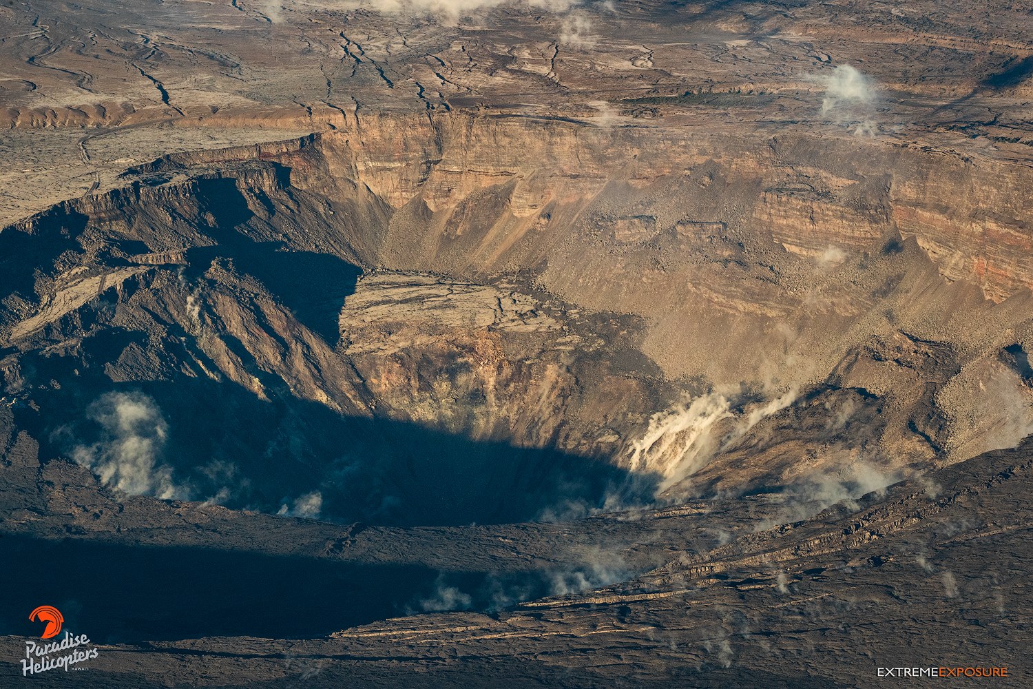
The new Halema‘uma‘u crater looks so radically different from what it was just a few months ago.
Sulfur dioxide gas emissions at the summit, Puʻu ʻŌʻō, and the ERZ remain drastically reduced at the combined rate of less than 300 tonnes/day.
Hazards are still present in the lower East Rift Zone (LERZ) eruption area and at the Kīlauea summit. Residents and visitors near recently active fissures and lava flows should stay informed, heed Hawaii County Civil Defense warnings, and be prepared, if necessary, to self-evacuate in the unlikely event of renewed activity. Please note that Hawaii County maintains a closure of the entire flow field and the vents and prohibits access to the area unless authorized through Civil Defense.
The Hawaiian Volcano Observatory (HVO) continues to closely monitor Kīlauea’s seismicity, deformation, and gas emissions for any sign of reactivation, and maintains visual surveillance of the summit and the East Rift Zone. HVO will continue to issue a weekly update (every Tuesday) and additional messages as warranted by changing activity.
Source : HVO
Photos : Hawai Trackers / Joseph Anthony , Bruce Omori .