March 07 , 2022.
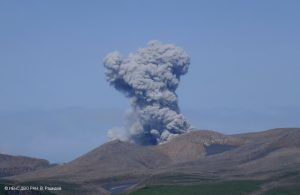
Alaska , Pavlof :
55°25’2″ N 161°53’37 » W,
Summit Elevation 8261 ft (2518 m)
Current Volcano Alert Level: WATCH
Current Aviation Color Code: ORANGE
Small explosions were detected yesterday at Pavlof Volcano. A high-resolution satellite image showed a small spatter cone developing in the active east crater but no active lava flows on the flanks of the volcano or widespread ash deposits. Elevated surface temperatures associated with this style of activity were also detected in overnight satellite images.
The small explosions associated with this eruption could happen at any time and may be accompanied by small ash plumes within the immediate vicinity of the volcano. The level of unrest at Pavlof can change quickly and the progression to more significant eruptive activity can occur with little or no warning.
Pavlof is monitored by local seismic and infrasound sensors, satellite data, web cameras, and remote infrasound and lightning networks.
Source : AVO.
Photo : Waythomas, Chris Alaska Volcano Observatory / U.S. Geological Survey( 2017).
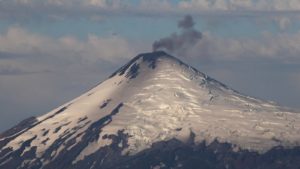
Hawaii , Kilauea :
19°25’16 » N 155°17’13 » W,
Summit Elevation 4091 ft (1247 m)
Current Volcano Alert Level: WATCH
Current Aviation Color Code: ORANGE
Activity Summary:
The summit eruption of Kīlauea Volcano, within Halemaʻumaʻu crater, continues at this time. Tremor at the summit remains elevated and tilt became deflationary yesterday at approximately 6:40 pm HST. All activity remains confined to the active lava lake and west vent area within the western part of Halemaʻumaʻu crater with several ooze outs along the margins of the Halemaʻumaʻu crater floor. All recent activity has been confined to the crater, and there are no indications of activity migrating elsewhere on Kīlauea.
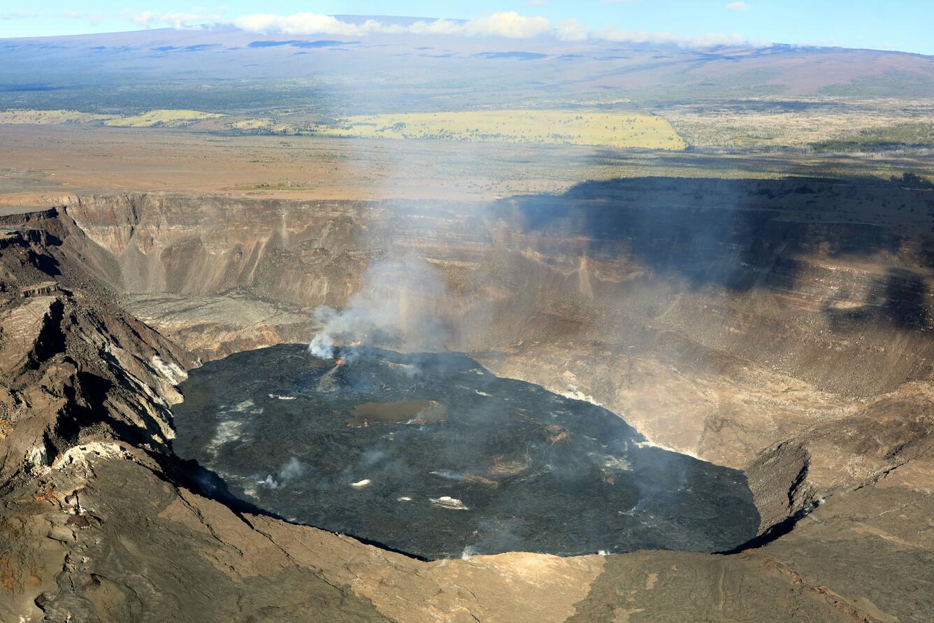
At approximately 8:15 a.m. on March 2, 2022, HVO geologists conducted an overflight of Kīlauea’s summit. The eruption, which resumed several hours earlier, at approximately 1 a.m., continues within Halema‘uma‘u crater. In this photo, active lava is visible near the west vent, near the center of the image, and Mauna Loa looms in the background.
Halemaʻumaʻu Lava Lake Observations:
Eruption of lava from the western vent into the active lava lake within Halemaʻumaʻu crater continues with flows of active lava erupting from the west vent and flowing into the western active lava lake. There have been several ooze outs along the east and north margins of the crater floor over the past 24 hours. The highest point on the Halemaʻumaʻu crater floor has risen approximately 97 meters (318 feet) since the eruption began on September 29, 2021. The erupted volume is 45 million cubic meters (59 million cubic yards) of lava as measured on January 25, 2021.
Summit Observations:
Inflationary summit tilt yesterday became deflationary at approximately 6:40 pm HST last night, and remains deflationary this morning. Seismic data shows that the volcanic tremor remains elevated. Earthquake activity at the summit remains below background levels. A sulfur dioxide (SO2) emission rate of approximately ~2500 tonnes per day (t/d) was measured on February 25.
Source : HVO
Photo : USGS / F. Trusdell.
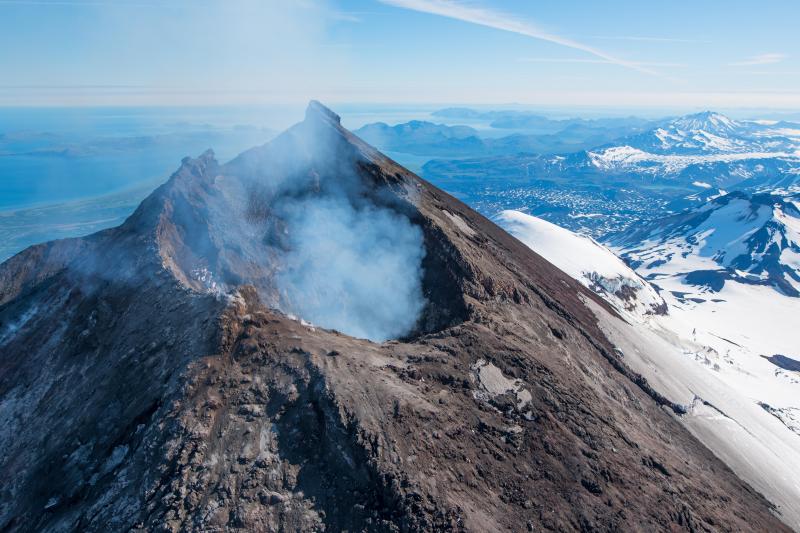
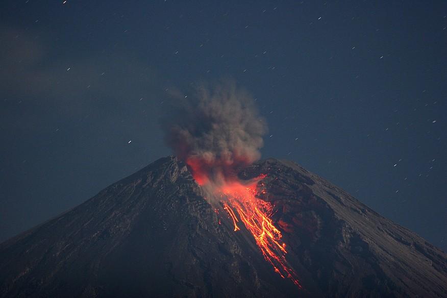
Indonesia , Semeru :
VOLCANO OBSERVATORY NOTICE FOR AVIATION – VONA
Issued : March 07 , 2022 .
Volcano : Semeru (263300)
Current Aviation Colour Code : ORANGE
Previous Aviation Colour Code : orange
Source : Semeru Volcano Observatory
Notice Number : 2022SMR49
Volcano Location : S 08 deg 06 min 29 sec E 112 deg 55 min 12 sec
Area : East java, Indonesia
Summit Elevation : 11763 FT (3676 M)
Volcanic Activity Summary :
Eruption with volcanic ash cloud at 00h35 UTC (07h35 local). Eruption and ash emission is continuing.
Volcanic Cloud Height :
Best estimate of ash-cloud top is around 14963 FT (4676 M) above sea level, may be higher than what can be observed clearly. Source of height data: ground observer.
Other Volcanic Cloud Information :
Ash-cloud moving to North west.
The eruption was observed with a height of smoke of about 400-700 meters above the crater, white / gray in color, oriented towards the North
Earthquakes are related to magma and tectonic activity. It was recorded:
– 28 earthquakes of eruptions/explosions
– 5 emission earthquakes
– 5 harmonic tremors
– 1 distant tectonic earthquake
Sources : Magma Indonésie , PVMBG.
Photo : M. Rietze , wikipedia .
Ecuador , Sangay / Reventador :
DAILY REPORT OF THE STATE OF SANGAY VOLCANO, Sunday March 06, 2022.
Information Geophysical Institute – EPN.
Surface Activity Level: High, Surface Trend: No change.
Internal activity level: High, Internal trend: No change.
Seismicity: From March 05, 2022, 11:00 a.m. to March 06, 2022, 11:00 a.m.:
Explosion (EXP): 30
Rains / Lahars:
Light rain was recorded in the region. **In the event of heavy rains, these could remobilize the accumulated materials, generating mudslides and debris that would descend on the flanks of the volcano and flow into the adjacent rivers.**
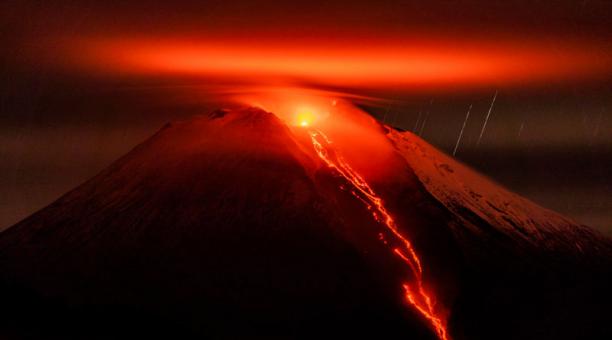
Emission / ash column:
The Washington VAAC reported 4 emissions whose heights varied between 870 and 1170 meters above the level of the crater with West, North-West and South-West directions.
Gas:
Gas emissions measured by the Mounts system recorded 1888 t at 1:56 p.m. on March 05, 2022
Other Monitoring Parameters:
The FIRMS system records 4 thermal anomalies in the last 24 hours.
Observation:
The weather conditions are permanently cloudy, so there are no observations of surface activity.
Alert level: Orange.
——————————————————————————————
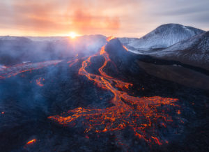
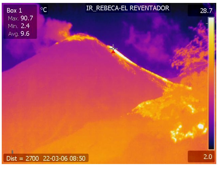
DAILY REPORT OF THE STATE OF THE REVENTADOR VOLCANO, Sunday March 06, 2022.
Information Geophysical Institute – EPN.
Surface Activity Level: High, Surface Trend: No change.
Internal activity level: Moderate, Internal trend: No change.
Seismicity: From March 05, 2022, 11:00 a.m. to March 06, 2022, 11:00 a.m.:
Explosion (EXP) 21
Long Periods (LP) 38
Emission Tremors (TREMI) 11
Harmonic Tremor (TRARM): 8
Rains / Lahars:
Rains were recorded in the volcano area but no lahars were generated.
Emission / ash column:
The Washington VAAC reported 2 emissions whose heights were 988 and 1338 meters above crater level and in a northwest and southwest direction, respectively.
Gas:
The MOUNTS system recorded 22.6 t on March 05, 2022 at 1:56 p.m. TL.
Other Monitoring Parameters:
The FIRMS system records 1 thermal anomaly, while the MIROVA system records 1 moderate thermal anomaly (19 MW), during the last 24 hours.
Observation:
Most of the time, the sector remained cloudy; however, when cleared, gas emissions and an active lava flow were observed through the infrared camera descending on the SE flank.
Alert level: Orange.
Source : IGEPN.
Photos : EFE. IGEPN.
Nicaragua , Telica :
The Telica volcano could record new explosions due to pressure buildup.
The Nicaraguan Institute for Territorial Studies (INETER) reported this Sunday that the Telica volcano, located in the department of León, could register new explosions.
The forecast was made due to the very low micro-seismicity that the volcano presents, which suggests the presence of a partial obstruction in the superficial part of the main conduit of the volcano.
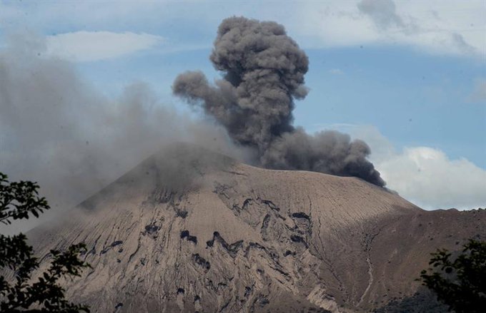
Given this, it is possible that there will be explosions due to the rise in pressure in the conduit, without this representing a danger for the communities installed beyond 1.5 kilometers from the crater.
For their part, the San Cristóbal, Cerro Negro, Momotombo, Masaya and Concepción volcanoes are within the normal activity parameter of active volcanoes.
Source : nuevaya.com.ni
Photo : Enfoque Noticias .