January 30 , 2022 .
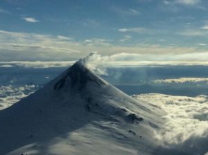
Philippines , Taal :
TAAL VOLCANO BULLETIN 30 January 2022 8:00 AM
A series of nine (9) weak phreatomagmatic bursts from the Taal Main Crater occurred between 3:50PM yesterday and 4:49AM this morning which produced steam-rich plumes 400 m to 900 m tall detected by visual and thermal cameras around Taal Lake. These events were very short-lived, lasting only 10 seconds to two minutes and produced only traces in the seismic record but were accompanied by distinct infrasound signals.
In the past 24-hour period, the Taal Volcano Network recorded thirty-one (31) volcanic earthquakes, including fourteen (14) volcanic tremor events having a duration of one (1) to three (3) minutes, sixteen (16) low-frequency volcanic earthquakes, one (1) hybrid event and low-level background tremor that has persisted since 7 July 2021 Activity at the Main Crater was dominated by upwelling of hot volcanic fluids in its lake which generated plumes 2000 meters tall that drifted southwest and northeast. Sulfur dioxide (SO2) emission averaged 10,036 tonnes/day on 29 January 2022. Based on ground deformation parameters from electronic tilt, continuous GPS and InSAR monitoring, Taal Volcano Island and the Taal region has begun deflating in October 2021.

Alert Level 2 (Increased Unrest) prevails over Taal Volcano. DOST-PHIVOLCS reminds the public that at Alert Level 2, sudden steam- or gas-driven explosions, volcanic earthquakes, minor ashfall, and lethal accumulations or expulsions of volcanic gas can occur and threaten areas within and around TVI. DOST-PHIVOLCS strongly recommends that entry into Taal Volcano Island, Taal’s Permanent Danger Zone or PDZ must be strictly prohibited, especially the vicinities of the Main Crater and the Daang Kastila fissure, and extended stays on Taal Lake. Local government officials are advised to continuously assess and strengthen the preparedness of previously evacuated barangays around Taal Lake in case of renewed unrest. Civil aviation authorities must advise pilots to avoid flying close to the volcano as airborne ash and ballistic fragments from sudden explosions and wind-remobilized ash may pose hazards to aircraft. DOST-PHIVOLCS is closely monitoring Taal Volcano’s activity and any new significant development will be immediately communicated to all stakeholders.
Source : Phivolcs
Photo : Onin casal /Agoncillo ERT
Alaska , Davidof :
51°57’15 » N 178°19’34 » E,
Summit Elevation 1076 ft (328 m)
Current Volcano Alert Level: ADVISORY
Current Aviation Color Code: YELLOW
An earthquake swarm in the vicinity of Davidof volcano began on Monday, January 24 and is continuing. The largest earthquake in the current sequence happened January 25, 4:02 PM AKST (January 26, 01:02 UTC) and had a magnitude of 4.9. A similar earthquake swarm occurred in December 2021. No signs of unrest have been observed in satellite images of the volcano. This earthquake activity may be associated with volcanic unrest, or could be due to regional tectonic activity. Due to the possibility of escalating volcanic unrest, AVO raised the Aviation Color Code and Volcano Alert Level for Davidof to YELLOW/ADVISORY on Wednesday January 26.
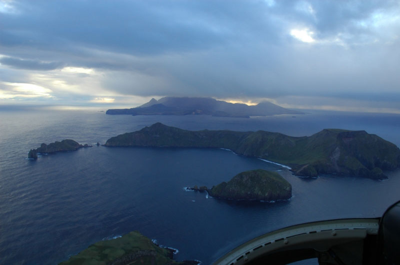
Davidof Volcano. Small islets are Lopy Island (l) and Pyramid Island (r). Little Sitkin on horizon
There is no real-time seismic monitoring network at Davidof volcano. The closest seismometers are approximately 9 miles (15 km) to the east of the volcano on Little Sitkin Island. Davidof is also monitored by satellite data and remote infrasound and lightning networks.
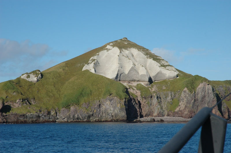
Davidof volcano is a mostly submerged stratovolcano in the Rat Islands group in the western Aleutian Islands, about 218 miles (350 km) west of Adak. The subaerial part of the volcano comprises Davidof, Khvostof, Pyramid, and Lopy islands, which encircle Crater Bay, a 1.5 mile (2.5 km) diameter caldera. The islands are built up from interbedded lava flows and explosive deposits. The volcano has been sparsely studied, but visits by Alaska Volcano Observatory geologists in 2021 documented thick sequences of rhyolite to dacite pyroclastic flow and fall deposits that represent the most recent explosive eruptions. The age of these deposits is unknown, but they appear older than Holocene deposits from nearby Segula and Little Sitkin. There are no known historical eruptions from Davidof.
Source : AVO
Photos : Neal, C. A. / Alaska Volcano Observatory / U.S. Geological Survey .
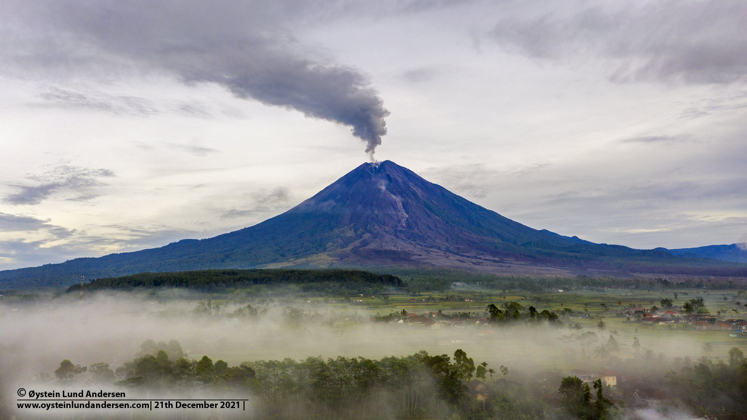
Indonesia , Semeru :
VOLCANO OBSERVATORY NOTICE FOR AVIATION – VONA
Issued : January 30 , 2022
Volcano : Semeru (263300)
Current Aviation Colour Code : ORANGE
Previous Aviation Colour Code : orange
Source : Semeru Volcano Observatory
Notice Number : 2022SMR16
Volcano Location : S 08 deg 06 min 29 sec E 112 deg 55 min 12 sec
Area : East java, Indonesia
Summit Elevation : 11763 FT (3676 M)
Volcanic Activity Summary :
Eruption with volcanic ash cloud at 01h29 UTC (08h29 local).
Volcanic Cloud Height :
Best estimate of ash-cloud top is around 14003 FT (4376 M) above sea level, may be higher than what can be observed clearly. Source of height data: ground observer.
Other Volcanic Cloud Information :
Ash cloud moving to north
Remarks :
Seismic activity is characterized by eruption, avalanche and gas emission earthquakes
Source : Magma Indonésie .
Photo : Oystein Lund Andersen
Ecuador , Sangay :
DAILY REPORT OF THE STATE OF SANGAY VOLCANO. January 29, 2022.
Surface activity level: High, Surface trend: No change.
Internal activity level: High, Internal trend: No change.
Seismicity: From January 28, 2022, 11:00 a.m. to January 29, 2022, 11:00 a.m.:
Explosions (EXP): 129
Emission Tremors (TREMI): 64
Long periods (LP): 10
Rains / Lahars:
Thanks to the WINDY application, rain was detected in the area. **In the event of heavy rains, these could remobilize the material accumulated in the gullies, generating mudslides and debris that would descend through the drains of the volcano and flow into the adjacent rivers.**
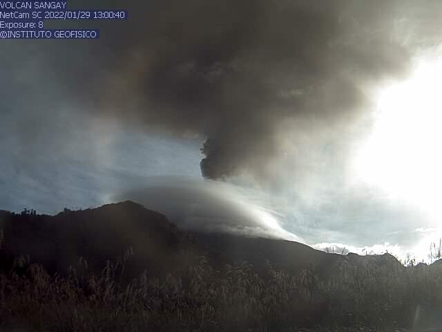
Emission / ash column:
At the end of the afternoon yesterday and today morning, several ash emissions were observed towards the South-West and their heights were around 1,200 and 2,000 meters above the level of the crater . The Washington VAAC reported 4 emissions observed on the satellites, the directions varied between the South and the South-West and the heights did not exceed 1200 meters above the level of the crater
Other Monitoring Parameters:
FIRMS recorded 47 thermal anomalies on Sangay in the past 24 hours. MIROVA recorded 2 high thermal anomalies (243 and 614 MW) and 1 moderate on the Sangay during the last 24 hours.
Observation:
During the afternoon of yesterday, the sector remained mainly cloudy, however, between the clouds at the end of the afternoon, an emission of gas and ash was observed. Today during the morning it became cloudy and similarly the emissions described were observed.
Alert level: yellow.
Source et photo : IGEPN.
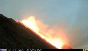
Guatemala , Santiaguito :
SPECIAL VULCANOLOGICAL BULLETIN.
PYROCLASTIC FLOW DESCENT.
As reported in previous bulletins, the Santa María-Santiaguito Volcanic Complex is in a period of high extrusive activity which has built a lava dome within the Caliente Dome crater and generated lava flows with directions West and Southwest.

From 6:45 p.m. (local time) the INSIVUMEH seismic network located on the Santiaguito volcano records the descent of constant avalanches, the volcano is covered with cloud cover, but the western and southwestern flanks of the Caliente dome can be the most affected. These avalanches are weak, moderate to strong characteristics, this activity caused moderate to strong ash fall at Loma Linda and moderate ash fall at San Marcos Palajunoj, El Palmar, Quetzaltenango.
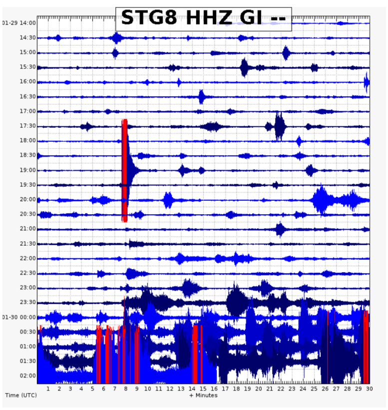
The constant avalanches that have occurred over the past few hours are observed in the seismic recording from station STG8.
This strong activity can continue to generate moderate to strong avalanches in a constant way which can cause collapses of materials accumulated in the dome of the crater and / or lava flows on the West and South-West flanks, which could cause the descent pyroclastic flows on the flanks of the Caliente dome, particularly in the West, South-West, South and South-East directions. As well as abundant ash fall in communities and farms near the volcano.
INSIVUMEH maintains instrumental and visual monitoring of volcanic activity on the Santa María-Santiaguito complex through its seismic stations, web cameras and OVSAN observers.
Source and graphics : Insivumeh
Photo : Annie Winson , earthobservatory.sg