January 12 , 2022 .
Ecuador / Galapagos , Fernandina Island / Isabella Island ( Wolf volcano) :
Information VOLCÁN FERNANDINA Nº 2022-001, Quito, Monday January 10, 2022.
At 12:30 UTC (06:30 – Galapagos), an earthquake of magnitude 2.8 was recorded in the area of the Fernandina volcano, about 8 km deep. Often, these earthquakes are precursors of the eruptive activity of this volcano. In addition, for a little over a year and a half, the Fernandina volcano has displayed a continuous process of inflation. Therefore, it is recommended to keep abreast of information provided by official sources in the event of a possible eruption.
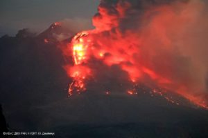
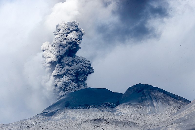
The dark lava flows at the far NW end of Fernandina caldera were emplaced in August 1978. An eruption beginning on August 8 produced an eruption cloud 4.5-6 km high. This was followed by the emplacement of a large lava flow from a 1-km-long fissure system on the NW caldera bench that flowed into the caldera lake. Lava fountaining was observed during visits to the caldera rim, on August 10-13 and 16-19. The eruption had ended by the 26th. Fresh lava flows in the foreground mantle the surface of the prominent SE caldera bench.
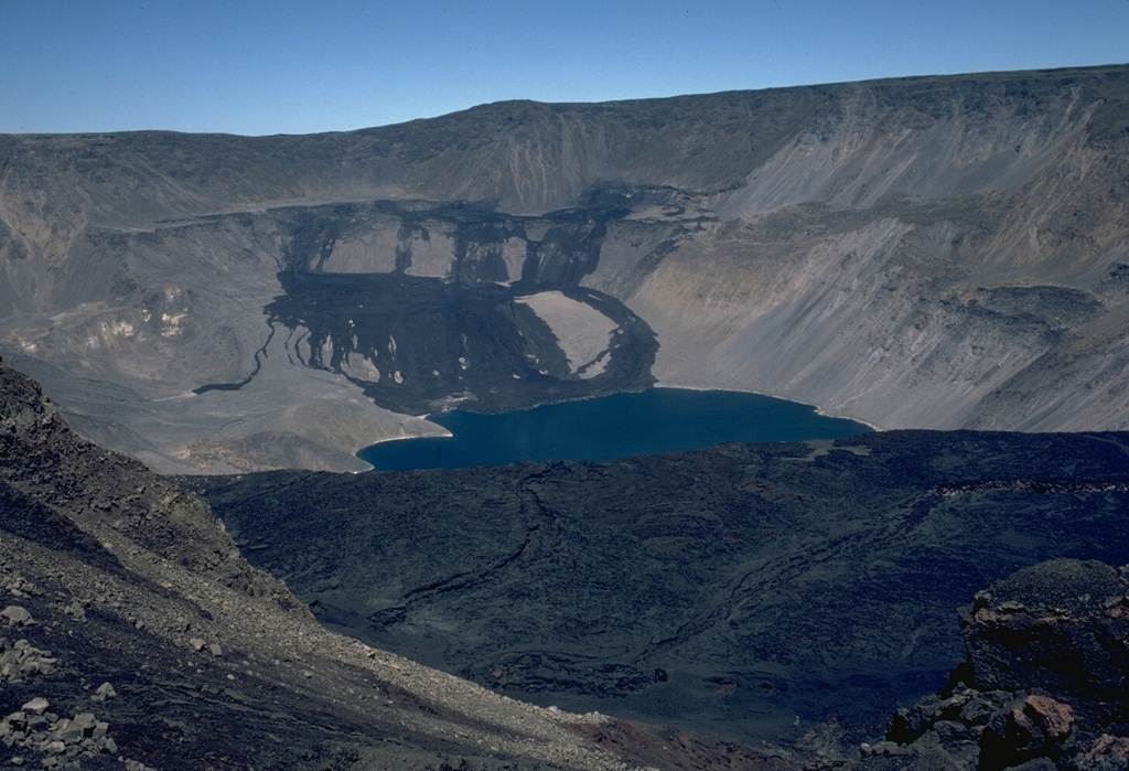
Fernandina, the most active of Galápagos volcanoes and the one closest to the Galápagos mantle plume, is a basaltic shield volcano with a deep 5 x 6.5 km summit caldera. The volcano displays the classic « overturned soup bowl » profile of Galápagos shield volcanoes. Its caldera is elongated in a NW-SE direction and formed during several episodes of collapse. Circumferential fissures surround the caldera and were instrumental in growth of the volcano. Reporting has been poor in this uninhabited western end of the archipelago, and even a 1981 eruption was not witnessed at the time. In 1968 the caldera floor dropped 350 m following a major explosive eruption. Subsequent eruptions, mostly from vents located on or near the caldera boundary faults, have produced lava flows inside the caldera as well as those in 1995 that reached the coast from a SW-flank vent. Collapse of a nearly 1 km3 section of the east caldera wall during an eruption in 1988 produced a debris-avalanche deposit that covered much of the caldera floor and absorbed the caldera lake.
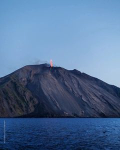
VOLCAN WOLF DAILY ACTIVITY REPORT, Monday January 1, 2022.
From: January 09, 2022, 11:00 a.m. To: January 10, 2022, 11:00 a.m.
Surface activity level: very high
Surface trend: no change
Internal: high
Internal trend: no change
Seismicity: The seismicity was carried out with data from the FER1 station
Volcano-Tectonics (VT) 2
Tremors of emissions (TREMI) 1

Emission / ash column:
According to satellite images, gas emissions can be observed, moving towards the southwest.
Other monitoring parameters:
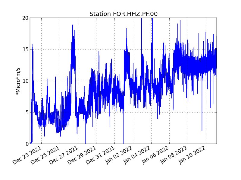
The MIROVA satellite system has reported 2 extreme thermal alerts (13,183 and 17,560 MW) and 2 very high (2,965 and 5,975 MW), likewise, the FIRMS satellite system has reported hundreds of thermal alerts over the last 24 time.
Observation:
At the time of publication of this report, satellite images of the Wolf volcano show that lava flows are very close (or perhaps already entering) in the sea southeast of the volcano.
Source : IGEPN. GVP.
Photos : Lee Siebert, 1978 (Smithsonian Institution). Roary Arbon .
Peru , Sabancaya :
Analysis period: from January 03, 2021 to January 09, 2021, Arequipa, January 10, 2021.
Alert level: ORANGE
The Geophysical Institute of Peru (IGP) reports that the eruptive activity of the Sabancaya volcano remains at moderate levels, that is to say with the recording of an average of 46 daily explosions, with columns of ash and of gas up to an altitude of 4.0 km above the summit of the volcano and their consequent dispersion. Therefore, for the following days, no significant change is expected in eruptive activity.
The IGP recorded and analyzed the occurrence of 434 earthquakes of volcanic origin, associated with the circulation of magmatic fluids within the Sabancaya volcano. An average of 46 explosions was recorded daily. During this period, Volcano-Tectonic (VT) earthquakes associated with rock fractures were located mainly in the Northwest of Sabancaya and presented magnitudes of M 2.8.
The monitoring of the deformation of the volcanic structure using GNSS techniques (processed with fast orbits) does not present any significant anomalies. However, in general, an inflation process was observed in the northern sector (around the Hualca Hualca volcano). Visual surveillance identified columns of gas and ash up to an altitude of 4.0 km above the summit of the volcano, which were scattered towards the West, South-West, South and South-East sectors of the volcano. Sabancaya. Satellite recordings identified the presence of 6 thermal anomalies (maximum value of 14 MW) associated with the presence of a lava body on the surface of the volcano’s crater.
RECOMMENDATIONS
• Keep the volcanic alert level in orange.
• Do not approach within a radius of less than 12 km from the crater.
Source : IGP
Photo : Galeria del Ministerio de Defensa del Perú
La Réunion Island , Piton de la Fournaise :
Press release of January 11, 2022 – 8:00 a.m.
The eruption that began on December 22, 2021 at around 3:30 a.m. local time continues. Over the last 72 hours, the amplitude of the tremor has been relatively stable. Fluctuations in the amplitude of the tremor can still occur; they are linked in part to the level of the lava lake which varies according to the degassing mode, and the sporadic openings of the tunnels which allow emptying of the cone.
Despite the bad weather conditions on the eruptive site, some observations could be made thanks to short clearings. Observations show that the lava projections at the level of the cone are still present and occasionally exceed the height of the cone. Numerous resurgences of lava flows are still visible at the roof of the lava tunnel downstream of the cone.
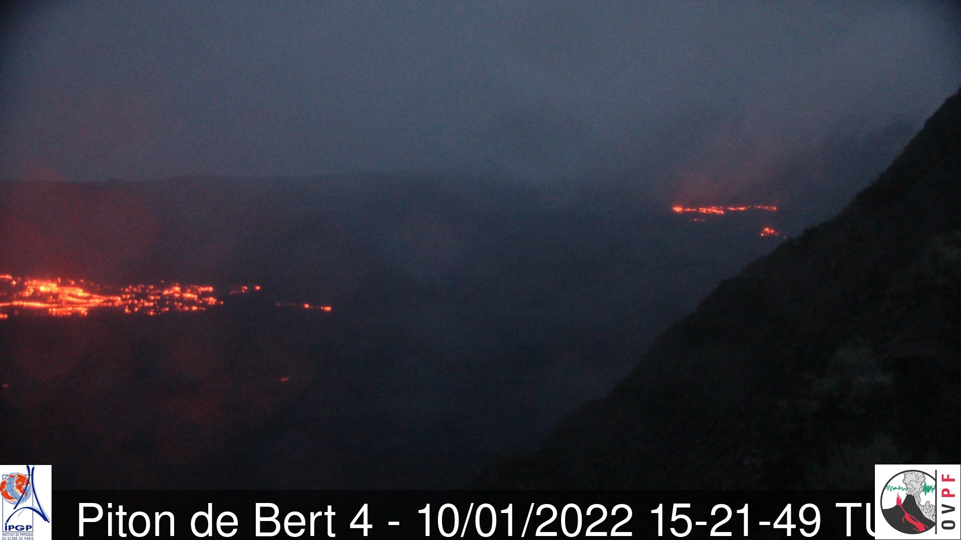
The images from the OVPF-IPGP-IRT webcam located at Piton de Bert show that the new flow arm put in place over the past 48 hours, and which runs along the southern rampart, is still active.
The front of this flow arm progresses only very slowly given the relatively low slopes in the area.
Over the last 24 hours:
– Five volcano-tectonic earthquakes, of low magnitude (<0.5), were recorded under the summit.
– The surface deformations still show a deflation at the level of the summit zone, linked to the emptying of the magma reservoir located under the summit (at about 2-2.5 km deep) feeding the eruptive site.
– Due to the very bad weather conditions on the volcano, no lava flow could be estimated by satellite method with the HOTVOLC platform (OPGC – Clermont Auvergne University).
Alert level: Alert 2-1 (eruption in the enclosure)
Source : OVPF.
Kamchatka , Karymsky :
VOLCANO OBSERVATORY NOTICE FOR AVIATION (VONA)
Issued: January 11 , 2022
Volcano: Karymsky (CAVW #300130)
Current aviation colour code: ORANGE
Previous aviation colour code: orange
Source: KVERT
Notice Number: 2022-05
Volcano Location: N 54 deg 2 min E 159 deg 26 min
Area: Kamchatka, Russia
Summit Elevation: 1486 m (4874.08 ft)
Volcanic Activity Summary:
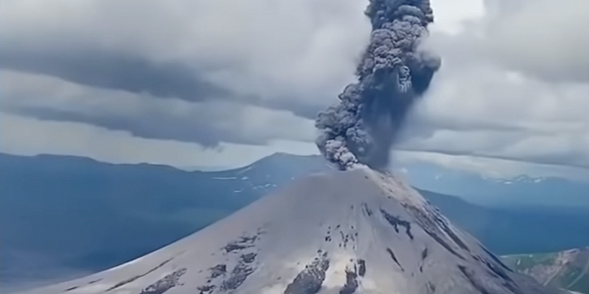
A moderate activity of the volcano continues. Satellite data by KVERT showed explosions sent ash up to 5 km a.s.l. at 03h45 UTC on 11 January. Ash cloud 7×7 km in size continues to drift to the southwest of the volcano.
A moderate gas-steam activity of the volcano continues. Ash explosions up to 10 km (32,800 ft) a.s.l. could occur at any time. Ongoing activity could affect international and low-flying aircraft.
Volcanic cloud height:
4500-5000 m (14760-16400 ft) AMSL Time and method of ash plume/cloud height determination: 20220111/0345Z – Himawari-8
Other volcanic cloud information:
Distance of ash plume/cloud of the volcano: 80 km (50 mi)
Direction of drift of ash plume/cloud of the volcano: SW / azimuth 231 deg
Time and method of ash plume/cloud determination: 20220111/0630Z – Himawari-8
Start time of explosion and how determined: 20220111/0345Z – Satellite data
Source : Kvert.
Photo : Daily Afisha. Ru
Iceland , Reykjanes Peninsula :
Nearly 900 earthquakes were detected by the SIL-seismic network of IMO this week, considerably fewer than the previous week when they counted around 4700. Around 660 earthquakes have been manually reviewed by the natural hazard specialist on duty at the IMO during the past week. Earthquakes that have not yet been reviewed manually are minor earthquakes on Reykjanes peninsula. The earthquake activity on Reykjanes peninsula continued to decrease and swarm that started on 21st of December was over this week.

Though around 660 earthquakes were detected there, but the activity significantly decreased after 5th of January. The earthquakes detected on the peninsula were located in four clusters, NE of Reykjanes, N of Grindavík, by Fagradalsfjall volcano and W of Kleifarvatn lake. The largest earthquake in these areas was M2.5 W of Kleifarvatn lake. The largest earthquake in Iceland this week was M2.8 and was detected on 9th of January W approximately 20 km W of Langjökull glacier. Seven minor earthquakes were located by the SW tip of Hekla volcano on 3rd of January.
Source : Vedur is .
Indonesia , Ili Lewotolok :
VOLCANO OBSERVATORY NOTICE FOR AVIATION – VONA
Issued : January 11 , 2022
Volcano : Ili Lewotolok (264230)
Current Aviation Colour Code : ORANGE
Previous Aviation Colour Code : orange
Source : Ili Lewotolok Volcano Observatory
Notice Number : 2022LEW02
Volcano Location : S 08 deg 16 min 19 sec E 123 deg 30 min 18 sec
Area : East Nusa Tenggara, Indonesia
Summit Elevation : 4554 FT (1423 M)
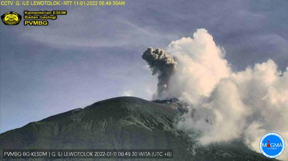
Volcanic Activity Summary :
Eruption with volcanic ash cloud at 00h48 UTC (08h48 local). Eruption and ash emission is not continuing.
Volcanic Cloud Height :
Best estimate of ash-cloud top is around 6794 FT (2123 M) above sea level, may be higher than what can be observed clearly. Source of height data: ground observer.
Other Volcanic Cloud Information :
Ash-cloud moving to east
Remarks :
Seismic activity is dominated by gas emission earthquake
Source et photo : Magma Indonésie .