December 22 , 2021 .
La Réunion , Piton de la Fournaise :
Press release of December 22, 2021 – 2:15 a.m.
Since 01:15 local time (21:15 UTC), a seismic crisis has been recorded on the instruments of the Volcanological Observatory of Piton de la Fournaise. This seismic crisis is accompanied by
rapid deformation for a few minutes. This indicates that the magma is leaving the magma reservoir and is spreading towards the surface.
An eruption is likely shortly within the next few minutes or hours.
Additional information will follow concerning the sector impacted by this magmatic propagation towards the surface.
Recommended alert level: Alert 1.
Press release of December 22, 2021 – 3:45 a.m.
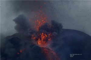
Following the seismic crisis that began at around 1:15 a.m. local time, the volcanic tremor synonymous with the arrival of magma near the surface has been recorded since around 3:30 a.m. local time (11:30 p.m. UT). According to OVPF records, the source of this tremor is located on the southern flank in the Enclos .
No visual confirmation of the start of an eruption could be made on webcams yet due to bad weather conditions and we cannot confirm the arrival of lava on the surface. However, the presence of a tremor shows the emission of hot and incandescent gases at the surface, and the possibility of lava emission in the short term.
Recommended alert level: Alert 2-1 (eruption in the enclos )
Source : direction de l’OVPF-IPGP
Photo : imaz press (page oficielle) via Sherine France .
Italy , Vulcano :
WEEKLY NEWSLETTER, from December 13, 2021 to December 19, 2021 (issue date December 21, 2021)
SUMMARY STATUS OF THE ACTIVITY
In view of the monitoring data, it is highlighted:
1) Temperature of the fumaroles of the crater: The temperature values continue to show a decreasing trend on the edge of the crater while they remain stable on the internal face.
2) CO2 flux in the crater area: The ground CO2 flux values in the summit area (VCSCS) show a downward trend, while remaining high.
3) SO2 flow in the crater area: SO2 flow appears at a high level
4) Geochemistry of fumarolic gases: The concentrations of magmatic gases (CO2, He) are at high levels.
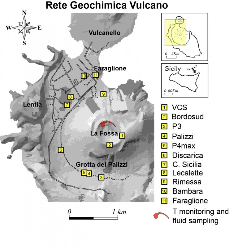
5) CO2 flux at the base of the La Fossa cone and in the Vulcano Porto area: The values at the base of the cone, automatically acquired by the VULCANOGAS network, are at high values. For the Faraglione site the recorded values can be considered as typical of the background level of the site.
6) Geochemistry of thermal aquifers: The physicochemical parameters are stable on the Sicilia and Bambara Camping sites.
7) Local seismicity: The phase of increase of low frequency events (VLP) has been interrupted which in any case have a high frequency of occurrence.
8) Regional seismicity: No earthquake with Ml> = 1.0 was located last week in the Vulcano region
9) Deformations – GNSS: The GNSS network does not show substantial variations.
10) Deformations – Inclinometry: The inclinometric network shows a tendency to return to the deformations observed in recent months.
11) Other observations: Gravimetry: The gravimetric variations located at the continuous station VSOCR are recorded. There are no variations attributable to significant phenomena of deep mass redistribution.
Monthly CO2 flow campaign: there is a general decrease in CO2 emissions in the Vulcano Porto area; the flow of CO2 emitted by the soil goes from 420 t / d on 11/10/2021 to 310 t / d on 12/14/2021.
Monthly well campaign: a slight decrease in the temperature values of the dissolved carbonate species is observed in all the monitored wells.

CO2 FLOWS IN THE CRATER ZONE
The values of the CO2 flux on the ground in the summit area (VCSCS) show high values around 9400 g / m2 / day, remaining in an order of magnitude above the averages recorded over the last 10 years. The average value of the CO2 flux (monthly average) in the month of December is currently 9327 g / m2 / day. A gradual decrease in degassing is observed on a monthly scale.
Source : INGV.
Photo : INGV , Webcam .
Tonga Islands , Hunga Tonga-Hunga Ha’apai :
Tonga’s erupting Hunga Ha’apai volcano put on a show of lightning at sunset tonight. As a large gaseous cloud continues to rise to 18km altitude and drift over all islands, all Tongan residents were advised by geologists this evening to protect their water tanks from possible acidic rainfall, until the volcanic eruption ceases.
Hunga Ha’apai is located 65km NNW of Nuku’alofa, from where the bright white gas cloud can be seen on the horizon.
Bursts of lightning at the top of the 18km high cloud were seen from Nuku’alofa and the Kanokupolu coast after 7:30pm tonight.
The Tonga Geological Service monitoring update at 6:50pm today said the intermittent gaseous and water vapour emission from Hunga Ha’apai had been consistent all day.
Taaniela Kula confirmed that yesterday’s eruption of volcanic ash and dust occurred between 9:30-9:40am, originating from Hunga Ha’apai, determined from NOAA/CIMSS HIMAWARI 8 AHI satellite imagery.
The eruption initially reached 3-16km altitude in a mushroom formation with a 30km radius, and during the rest of the day reached 18km altitude over the ‘Otu Mu’omu’a and ‘Otumotu Lulunga of Ha’apai, as well as ‘covering Tongatapu and ‘Eua.

On 20 Dec., at 4:40pm, the ash/dust eruption maintained 18 km altitude and reached over the Vava’u Islands including Fonualei Island. At 7:00pm, it reached Niuafo’ou Island and beyond. At 9:00pm, it reached Niuatoputapu and Tafahi Islands, he said.
The ash cloud cleared today, but the gaseous emission continued with the cloud formation drifting over Tonga.
Source : matangitonga.to
Photos : Shane Egan via Sherine France , Mary Lyn Fonua / matangitonga.to.
Italy / Sicily , Etna :
WEEKLY NEWSLETTER, from December 13, 2021 to December 19, 2021 (issue date December 21, 2021)
SUMMARY STATUS OF THE ACTIVITY
In view of the monitoring data, it is highlighted:
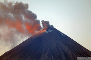
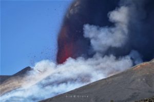
1) VOLCANOLOGICAL OBSERVATIONS: Modest effusive activity of two open eruptive vents in the western wall at the bottom of the Valle del Bove. Strombolian activity of the Southeast Crater, with very abundant ash emissions on December 14 and 15. Degassing activity on the other summit craters.
2) SEISMOLOGY: Weak seismic activity due to fracturing with Ml> = 2.0; amplitude of the volcanic tremor on medium-high to high levels until December 15, thereafter on medium-low to low levels.
3) INFRASOUND: Weak infrasound activity in the periods when it was possible to make observations.
4) SOIL DEFORMATION: During the past week, the soil deformation monitoring networks have not recorded any significant changes, not even in correspondence with the eruption event of December 13th.
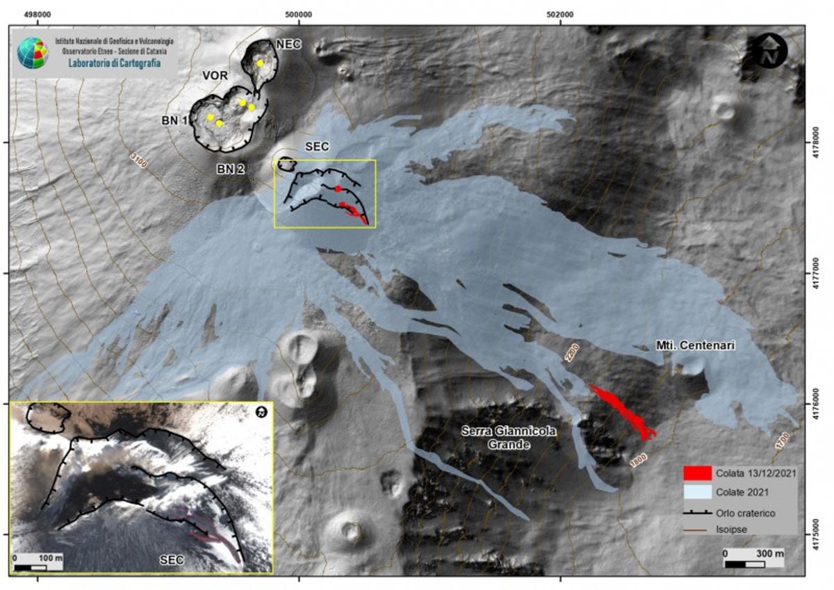
Fig. 3.1 Map of the summit area and the lava field of December 13, 2021 on a shaded model of the terrain. In the yellow box, the detail of the SEC edge of the Skysat satellite image acquired on December 15, 2021 at 9:26 UTC, spatial resolution 50 cm; the red line delimits the deposit of incoherent material detected by the satellite images, the black line set back the edges of the crater. Red circle: active mouth; yellow circle: degassing port.
5) GEOCHEMISTRY: The flow of SO2 occurs at an average level
The CO2 fluxes from the soil recorded by the Etnagas network place them at medium-high levels.
The partial pressure of dissolved CO2 shows values consistent with the seasonal trend.
There is no update on the values of the helium isotope ratio measured in the peripheral manifestations of Etna. The latest figure from 11/30/2021 stood at medium to high levels (0.59).
There are no updates for the C / S report.
6) SATELLITE OBSERVATIONS: The thermal activity in the summit area was at a low level after the effusive activity of December 13-14, 2021.
VOLCANOLOGICAL OBSERVATIONS
During the week, the monitoring of the volcanic activity of Etna was carried out thanks to the analysis of the images of the surveillance cameras of the INGV, the Etneo Observatory (INGV-OE) and through the observations made by INGV staff during the inspections on 13 (in the town of Monte Fontane) and on 14 and 15 December (in the summit area).
In general, the week was characterized by modest and brief effusive activity from two open eruptive vents in the lower western wall of the Valle del Bove and by Strombolian activity and ash emission from the Southeast Crater (SEC), which became very intense between December 14 and 15. Variable entity degassing activity of the other summit craters (Fig. 3.1).

In particular, from around 4.30 p.m. UTC on December 13, the Southeast Crater (SEC) produced weak intracrater Strombolian activity with sporadic ash emissions, which were scattered in the summit area.
From 17:05 UTC on December 13, the opening of a main effusive vent was observed located at an altitude of 2100 m, in the western wall of the Valle del Bove, immediately north of the relief of the Serra Giannicola Grande ( Fig. 3.1.), And another effusive vent located a few tens of meters below the main one. These vents did not produce significant explosive activity and fed a small lava flow which, by the morning of December 15, was already cooling. The flow, which was mapped using the Skysat satellite image of December 15 (Fig. 3.1), developed for about 600 m in a south-easterly direction and reached the base of the Valle del Bove, at a altitude of 1820 m above sea level, covering an area of 33×103 m2.
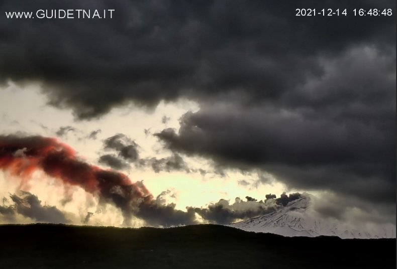
On December 14, from around 11:15 UTC, an intracrater Strombolian activity was again observed at the Southeast Crater (SEC), with the emission of abundant very fine material and the formation of an ash cloud. which reached a height of about 7000 m, dispersing in a southerly direction. The ash production had a variable trend throughout the night between December 14 and 15, alternating phases in which the matter emitted decreased significantly, with phases in which the emission was abundant and continuous, to finally cease in the early hours of December 15. The ash produced was extremely fine, almost dusty, reddish in color. The ash fall affected the southern sector of the volcano and was reported as far as Capo Passero (SR).
Satellite images (yellow box in figure 3.1) highlighted the presence of a small deposit of incoherent material, about 250 m long, in the depression formed following the activity of October 23, 2021, which deeply dug the eastern part of the crater rim. This deposit was probably formed due to the partial remobilization of the pieces of lava emitted during the Strombolian activity of December 14. Detailed investigations will be carried out to better define the extent of the morpho-structural changes that have affected the Southeast Crater (SEC).
Source : INGV.
Photos : INGV , Gio Giusa , Guide Alpine Vulcanologiche Etna
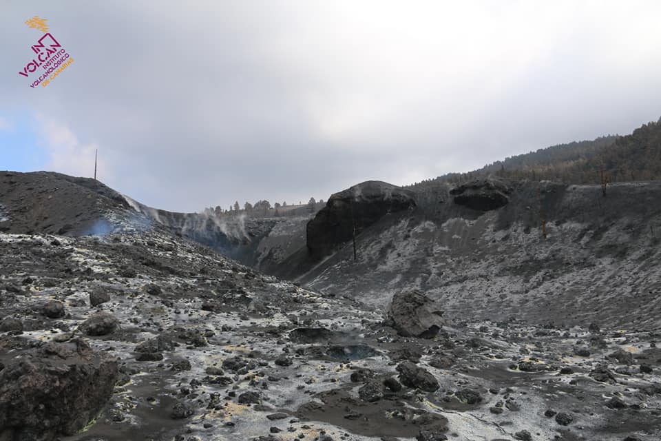
Spain / La Palma : Cumbre Vieja :
December 21, 2021 09:00 UTC. Volcanic monitoring continues on La Palma.
Since the last declaration, 9 earthquakes have been located on the island of La Palma, none of them have been felt by the population.
The magnitudes vary between 1.9 and 2.3 (mbLg). The localization of hypocenters continues under the central area of Cumbre Vieja in the same areas as the previous days. 8 earthquakes were located at depths between 6 and 14 km and one earthquake at a depth greater than 30 km.
The volcanic tremor continues unobserved, maintaining the seismic noise at levels close to the pre-eruptive period.
The island’s network of permanent GNSS stations shows a partial reversal of the elevation recorded on December 19 at station LP03, which is closest to the eruptive centers. In the rest of the stations, no significant deformation is observed which could be associated with volcanic activity.
No type of emission is seen, without the possibility of measuring the height of the cone today.
Scientists again corroborated « signs of exhaustion » from the Cumbre Vieja volcano on Tuesday. All the parameters analyzed to assess the volcanic activity point in this direction, with the sole exception of the local deformation of the terrain in the station closest to the emitting centers, which reached 8 centimeters, but has already partially reversed, but that requires monitoring and experts call for caution. Rubén Fernández, spokesperson for the steering committee of the Canary Islands Volcanic Emergency Plan (Pevolca), admitted on Tuesday that the biggest concern right now was gas concentrations in the regions of Puerto Naos, El Remo and La Bombilla .

The network of permanent GNSS stations (National Geodetic Network of Reference Stations) of La Palma shows that the deformation and altitude recorded in station LP03, which is closest to the eruptive centers of the volcano, have already started their inversion and are in the study. The national responsible for volcanic monitoring of the National Geographic Institute (IGN) and spokesperson for the Scientific Committee of Pevolca, Carmen López, told a press conference that this local deformation recorded in the station of Jedey has started yesterday morning and, after reaching the maximum of 8 cm at 22:00, began its inversion, which continues this Monday.
López explained that this deformation should be interpreted with the rest of the observation parameters and clarified that once the eruption is over, seismicity and residual deformations can continue to be recorded, as has already happened in the case of the eruption of the El Hierro volcano, where there were episodes of deformation and seismicity that lasted for months and, even, years. Regardless, she pointed out that observations, both directly on the surface and from monitoring systems, continue to corroborate signs of exhaustion of the eruptive process, although a further rise in the Strombolian activity and the emission of castings are not excluded.
Sources : IGNes , El Pais .
Photos : Involcan , I love the world .
Indonesia , Semeru :
VOLCANO OBSERVATORY NOTICE FOR AVIATION – VONA
Issued : December 22 , 2021
Volcano : Semeru (263300)
Current Aviation Colour Code : ORANGE
Previous Aviation Colour Code : orange
Source : Semeru Volcano Observatory
Notice Number : 2021SMR87
Volcano Location : S 08 deg 06 min 29 sec E 112 deg 55 min 12 sec
Area : East java, Indonesia
Summit Elevation : 11763 FT (3676 M)
Volcanic Activity Summary :
Pyroclastic flow occured from the edge of lava deposit at 03h27 UTC ( 10h27 local )
Volcanic Cloud Height :
Ash-cloud is not visible
Other Volcanic Cloud Information :
Ash-cloud moving to southeast.
Remarks :
Lava flow is observed through the Southeast direction of the Semeru summit crater.

The volcano was clear / hazy.
Two strong emissions of white smoke at an altitude of about 300 meters, thick, were observed in the southwest.
An incandescence is observed visually when the volcano is clearly visible
Seismicity is the activity of magma as well as tectonic activity.
– 3 eruption earthquakes / explosions
– 21 avalanche earthquakes
– 4 earthquakes of emissions
– 1 vibration of lahar.
Sources : Magma Indonésie , PVMBG.
Photo : Oystein Lund Andersen .