December 03 , 2021 .
Ecuador , Sangay :
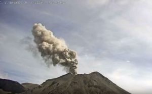
Thursday 02 December 2021
At 04:03 TL, the SAGA seismic station recorded a major explosion. Therefore, there is a possibility of ash fall in the areas west and southwest of the volcano, in the province of Chimborazo. It is recommended that you take appropriate measures and receive information from official sources. The Institute of Geophysics is monitoring and any news will be reported.
Thursday 02 December 2021
From 04:40 TL, thanks to satellite images (W-VAAC), it was possible to see 2 ash clouds; the first reaches 10 km above the crater and the second reaches 7 km above the crater, with both emissions heading west. Therefore, there is a possibility of ash fall in Chimborazo province. This phenomenon has been persistent during the current eruptive period which began in May 2019. IG-EPN continues to monitor the event and will provide timely information if changes in the seismic signals are detected.
The Geophysical Institute is monitoring and any news will be disseminated.

DAILY REPORT ON THE STATE OF SANGAY VOLCANO.
Surface activity level: High, Surface trend: Ascending.
Internal activity level: High, Internal trend: Ascending.
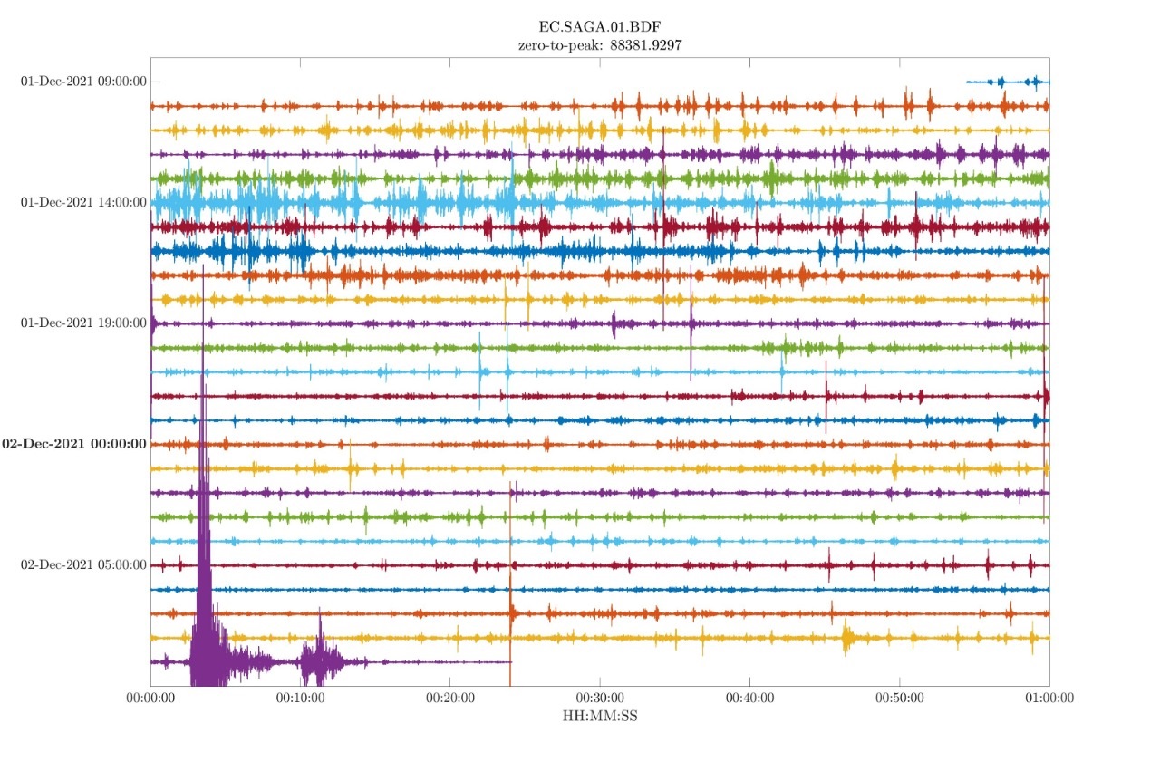
Seismicity: From December 01, 2021, 11:00 a.m. to December 02, 2021, 11:00 a.m .:
Long-term events (LP): 1470
Explosions (EXP) 100
Emission Tremors (TREMI) 72
Rains / Lahars:
There was rain in the area.
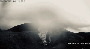
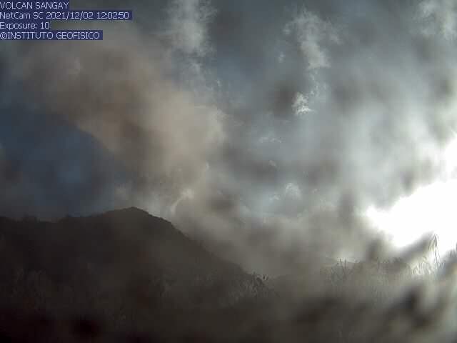
Emission column / ash:
In the morning, gas emissions with ash were observed at altitudes up to 1,500 meters above the summit dispersing to the west. The Washington VAAC reported 3 ash clouds; the first reached 10 km above the crater, the second 7 km above the crater, the two emissions were directed towards the West and the third reached 1770 meters above the crater dispersing in a North-West direction.
Other monitoring parameters:
The FIRMS and MIROVA satellites do not report thermal alerts during the last 24 hours.
Observation:
During the morning the volcano remained clear and gas emissions with ash were observed, for the moment the area is cloudy.
Alert level: yellow.
Source et photos : IGEPN.
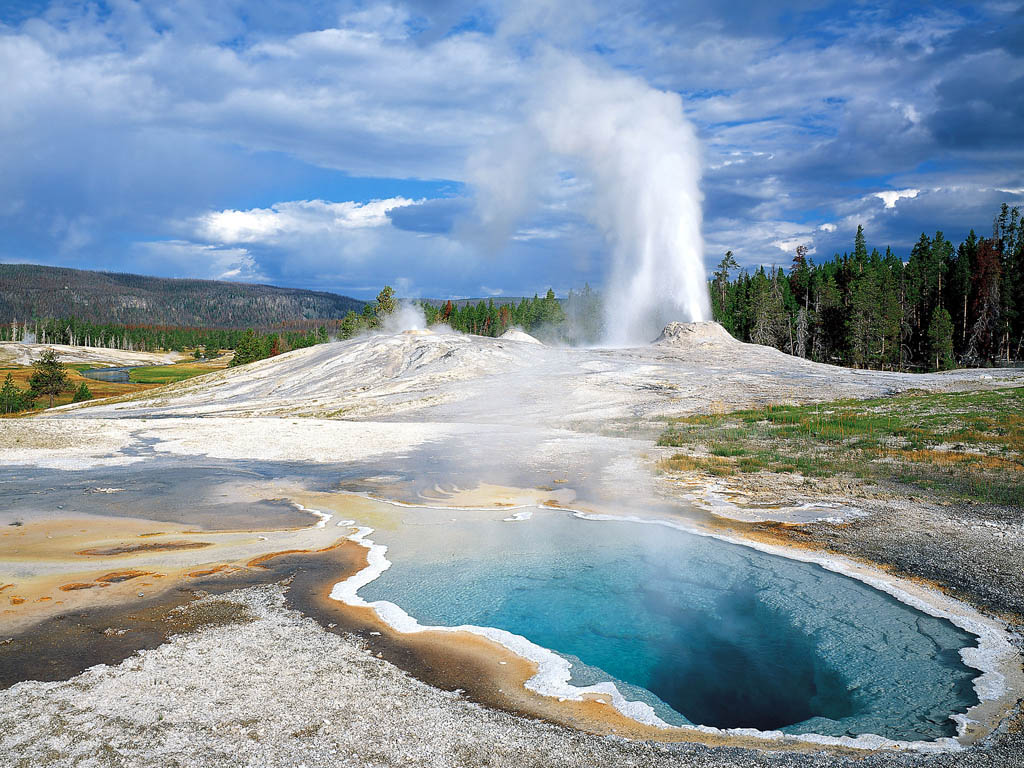
United – States , Yellowstone :
44°25’48 » N 110°40’12 » W,
Summit Elevation 9203 ft (2805 m)
Current Volcano Alert Level: NORMAL
Current Aviation Color Code: GREEN
Recent work and news
During the usual seasonal closure of Yellowstone National Park (as part of the transition from summer to winter operations), Yellowstone Volcano Observatory scientists and collaborators conducted multidisciplinary research experiments in the Upper Geyser Basin, deploying numerous instruments in the region near Old Faithful. The work is part of an ongoing effort to better understand geyser plumbing systems, chemistries, and eruptive patterns.
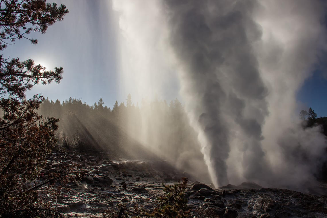
Steamboat Geyser continues to be active, with two eruptions in the past month: on November 12 and 24. This brings the total number of eruptions for the year to 19.
Seismicity
During November 2021, the University of Utah Seismograph Stations, responsible for the operation and analysis of the Yellowstone Seismic Network, located 137 earthquakes in the Yellowstone National Park region. The largest event of the month was a minor earthquake of magnitude 2.5 located ~3.5 miles south of the South Entrance of Yellowstone National Park on November 10 at 5:56 AM MST.
November seismicity in Yellowstone was marked by 2 earthquake swarms:
1) A cluster of 60 earthquakes occurred during November 26–27 located ~14 miles north-northeast of Old Faithful. These earthquakes continued from a sequence that began on September 16. The largest November event (magnitude 1.8) occurred on November 26 at 8:00 AM MST.
2) A small swarm of 14 earthquakes occurred November 14–27 located ~15 miles east-northeast of West Yellowstone, MT. The largest event (magnitude 1.3) occurred on November 14 at 1:56 AM MST.
Earthquake sequences like these are common and account for roughly 50% of the total seismicity in the Yellowstone region.
Yellowstone earthquake activity remains at background levels.
Ground deformation
Subsidence of Yellowstone Caldera has been ongoing since 2015, but that deformation typically pauses or turns to slight uplift during the summer months due to seasonal groundwater recharge. The summer pause in 2021 has now ended, and subsidence has resumed across the caldera. This subsidence occurs at a rate of about 1–2 inches per year. A GPS station near Norris Geyser Basin was showing slight uplift during summer 2021, and the source of this deformation was initially unclear. In November, however, this deformation reversed, and the area is now experiencing a small amount of subsidence. The timing of the minor summer uplift at Norris corresponds to the summer pause in subsidence of the caldera, suggesting that Norris was also impacted by seasonal groundwater recharge. Deformation of the region therefore has remained relatively constant over the past several years, with little change in the Norris area and slight subsidence of the caldera.
Source : YVO.
Photos : USGS , steamboat /Mara Reed .
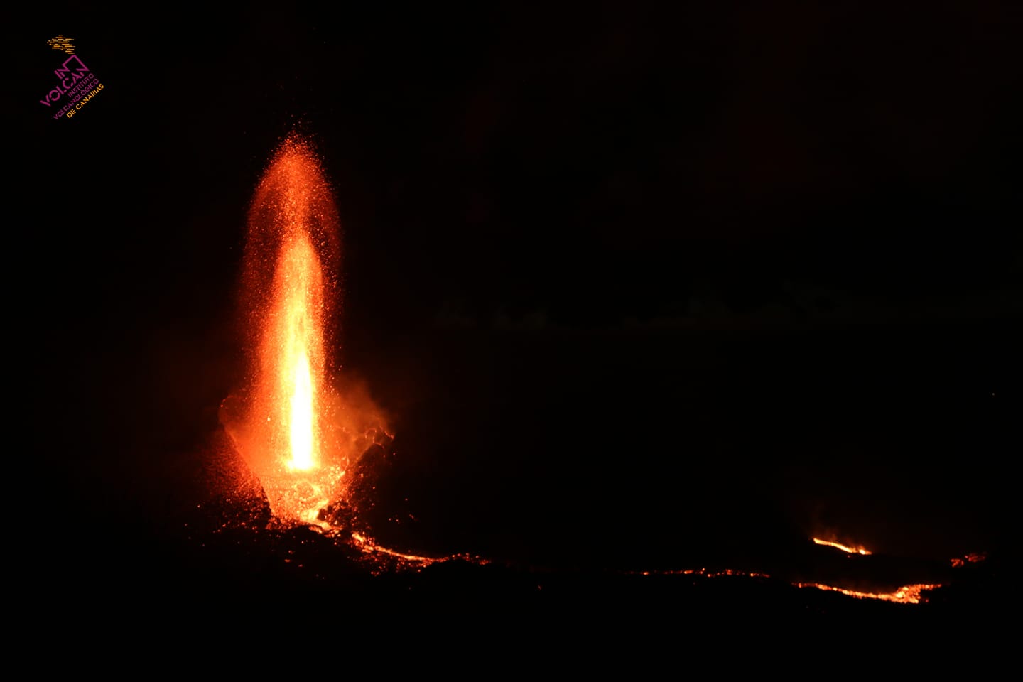
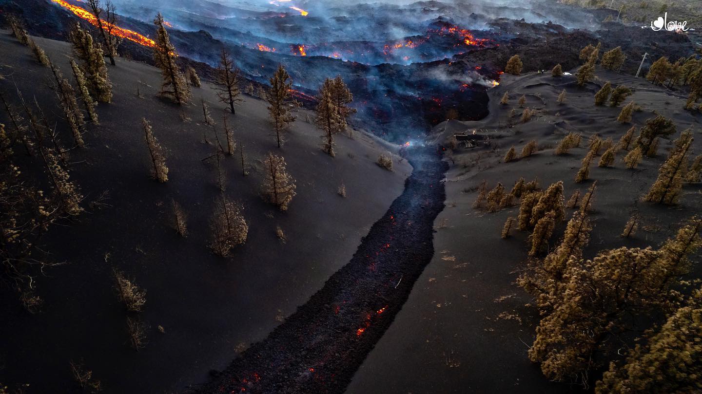
Spain / La Palma , Cumbre Vieja :
02 December 2021 10:00 UTC. Eruptive activity continues on La Palma.
Since the last declaration, a total of 231 earthquakes have been located in the area affected by the volcanic reactivation on the island of La Palma, of which 8 were felt by the population.
Seismicity continues below the central area of Cumbre Vieja in the same areas of the previous days, 226 of these earthquakes are located at depths of 6-16 km and the rest (5) at depths greater than 24 km.
The maximum recorded magnitude is 4.2 (mbLg) corresponding to today’s earthquake at 05:14 UTC, with a depth of 11 km and intensity IV (EMS98).
The amplitude of the tremor signal was maintained at average levels with intensifying pulses.
As yesterday, the network of permanent GNSS stations on the island does not show a clear tendency to deformation of the stations closest to the eruptive centers.
In the rest of the stations, the slight deflation possibly linked to the deep seismicity has stabilized, except in LP01 which continues to record it.
In view of the image calibrated at 08:30 UTC, a column height of 1900 m is estimated, and a cloud is diffusing in a south-southwest direction.
The height of the cone is measured by obtaining a value of 1.125 m on sea level.
The eruptive activity of effusive Strombolian character on the volcano of La Palma continues to focus on the new pyroclastic cone, where the small landslides that occur inside provide blocks that are transported by the flows with assimilation fast. On the other hand, activity in the main cone is sparse and intermittent and ash emission predominates, which does not mean that the magma cannot come out again later, said the scientific spokesperson for the Plan. emergency for the volcanic risk of the Canary Islands (Pevolca), Stavros Meletlidis. He said several hotbeds could alternate, because although the magma now comes out of the eastern part later, it could find its way back through the main cone.
The height reached by the lava fountains during the eruption of the volcano of La Palma on Thursday reached six hundred meters above sea level, according to data shared by the Volcanological Institute of the Canary Islands (Involcan).
The eruption of the Cumbre Vieja volcano on the Canary Island of La Palma has been in preparation for four years, according to a preliminary analysis of the data, writes Marc-Antoine Longpré, a New York volcanologist from Queens College, in an article published today by Science.
The expert reviews the facts before and since its explosive eruption on September 19, showing « behavior contrary » to that of basaltic volcanoes, data that offers « valuable lessons » for the prediction of eruptions.
Sources : IGN es , El Pais.
Iceland , Grímsvötn :
Volcanic eruption this weekend “not unlikely”
All eyes will be on the data coming out of Grímsvötn this weekend, according to geophysics professor Magnús Tumi Guðmundsson. The current jökulhlaup flood could be followed by a volcanic eruption, and authorities must be prepared, he says. Grímsvötn is Iceland’s most active volcano and last erupted in 2011 and 2004.
The peak of the glacial flood late this weekend could potentially be the trigger for an eruption, Magnús Tumi says. The civil protection agency has declared an uncertainty alert over the flood—the lowest of three emergency alert levels used in Iceland.
Scientists flew with the coastguard to Grímsvötn yesterday to check the meters and equipment in the huts there. Water has been flowing out from Grímsvötn for over a week and is now counted as a jökulhlaup. The level of Gígjukvísl river, which runs from the glacier, has risen to approximate summer levels, when glacier melt is at its fastest. The current flow rate of meltwater from Grímsvötn is 800-1,000 cubic metres per second, but that figure could increase fourfold before the end of the weekend.
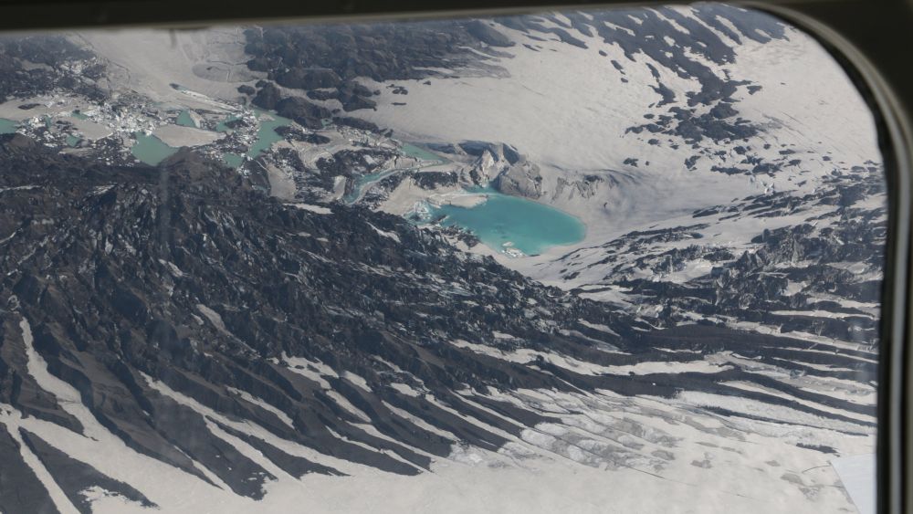
Glacial ice at Grímsvötn began visibly sinking a week ago and by yesterday it had sagged ten metres.
Magnús Tumi says the flood so far, and the events leading up to it, have been by the book. Things developed faster than in the 1996 flood, but slower than in 2010. The current flood is expected to peak late on Sunday or the early hours of Monday.
How likely is a volcanic eruption? “Fairly likely. We must be prepared for that. When the water drops at Grímsvötn. Grímsvötn could sink up to a hundred metres. That could be enough of a lightening of the load on top of the magma chamber for an eruption to break out, as happened last in 2004. If that happens, as conditions stand now, it is likely that will be when it [the release of water] reaches its maximum. All eyes will be on all the meters around the weekend. It happens sometimes, and sometimes not. We just need to be ready,” he says.
Source : RUV.
Photo : Atlantsflug – Ljósmynd.
Chile , Nevados de Chillan :
Special Report on Volcanic Activity (REAV), Ñuble region, Nevados de Chillán volcanic complex, December 03, 2021, 01:20 a.m. local time (Continental Chile).
The National Service of Geology and Mines of Chile (Sernageomin) publishes the following PRELIMINARY information, obtained thanks to the monitoring equipment of the National Volcanic Monitoring Network (RNVV), processed and analyzed at the Volcanological Observatory of the Southern Andes ( Ovdas):
On Friday December 03, 2021, at 00:57 local time (03:57 UTC), the monitoring stations installed near the Nevados de Chillán volcanic complex recorded an earthquake associated with fluid dynamics (long period LP type) in the volcanic system.

The characteristics of earthquakes after their analysis are as follows:
ORIGINAL TIME: 00:57 local time (03:57 UTC)
REDUCED DISPLACEMENT: 550 (cm2)
ACOUSTIC SIGNAL: 12.4 Pascals (Pa) reduced to 1 km.
OBSERVATIONS:
The characteristics of the surface activity associated with this event are as follows:
HEIGHT OF INCANDESCENCE: Not recorded.
The volcanic technical alert remains at the Yellow level.
Sources : Sernageomin.
Photo : Cesar Lara Cancino ( Archive).