November 20 , 2021.
Spain / La Palma , Cumbre Vieja :
November 19, 2021 10:00 UTC. Eruptive activity continues on La Palma.
Since the last declaration, 39 earthquakes have been located in the southern part of the island of La Palma, near the ongoing volcanic eruption. Three of these earthquakes were felt by the population.
The number of earthquakes has decreased compared to the previous two days and most of the seismicity is at depths greater than 30 km.
At 01:08 UTC today, an earthquake with a magnitude of 5.1 mbLg was recorded at a depth of 36 km and felt by the population with a maximum intensity of IV (EMS), it is the largest earthquake since the series began on September 11.

The tremor signal continues at a low level with slight fluctuations over the last few hours.
The island’s network of permanent GNSS stations shows an elevation of about 4 cm with a south-southwest deformation at station LP03, which is closest to the eruptive centers.
In the rest of the stations, the slight deflation possibly linked to the deep seismicity has stabilized.
In view of the image calibrated at 08:45 UTC, a column height of 3500 m is estimated, and an ash cloud disperses in an East-South-East direction.
The height of the cone is measured by obtaining a value of 1128 m at sea level.
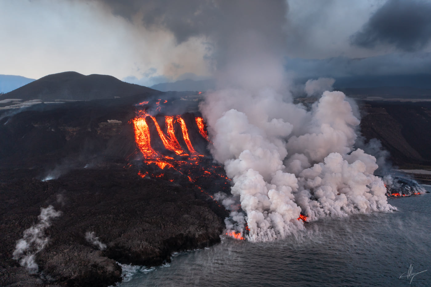
La Palma recorded in the early morning of this Friday an earthquake of magnitude 5.1 in the municipality of Villa del Mazo. The earthquake, the largest since the eruption of the Cumbre Vieja volcano began exactly two months ago, was located 37 kilometers deep and felt on several islands in the Canary archipelago, such as Tenerife, La Gomera and El Hierro. One of the volcano’s three active fronts is advancing at 20 meters per hour through a so far untouched area, destroying homes and farms.
Seismicity at intermediate levels continues to decrease and remains at high depths, volcanic tremors are low and deformation continues to decrease, although an increase has been localized in the Jedey area.
Sulfur dioxide emissions also continue their downward trend, ranging between 17,000 and 26,000 tonnes per day, while carbon dioxide emissions continue to increase, with between 2,400 and 2,600 tonnes per day. day.
Sources : IGN es , El Pais .
Photo : ALBERT GARCIA , Van Marty @martydelapalma
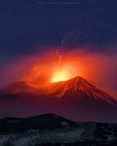
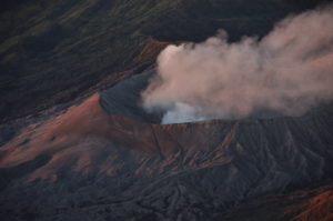
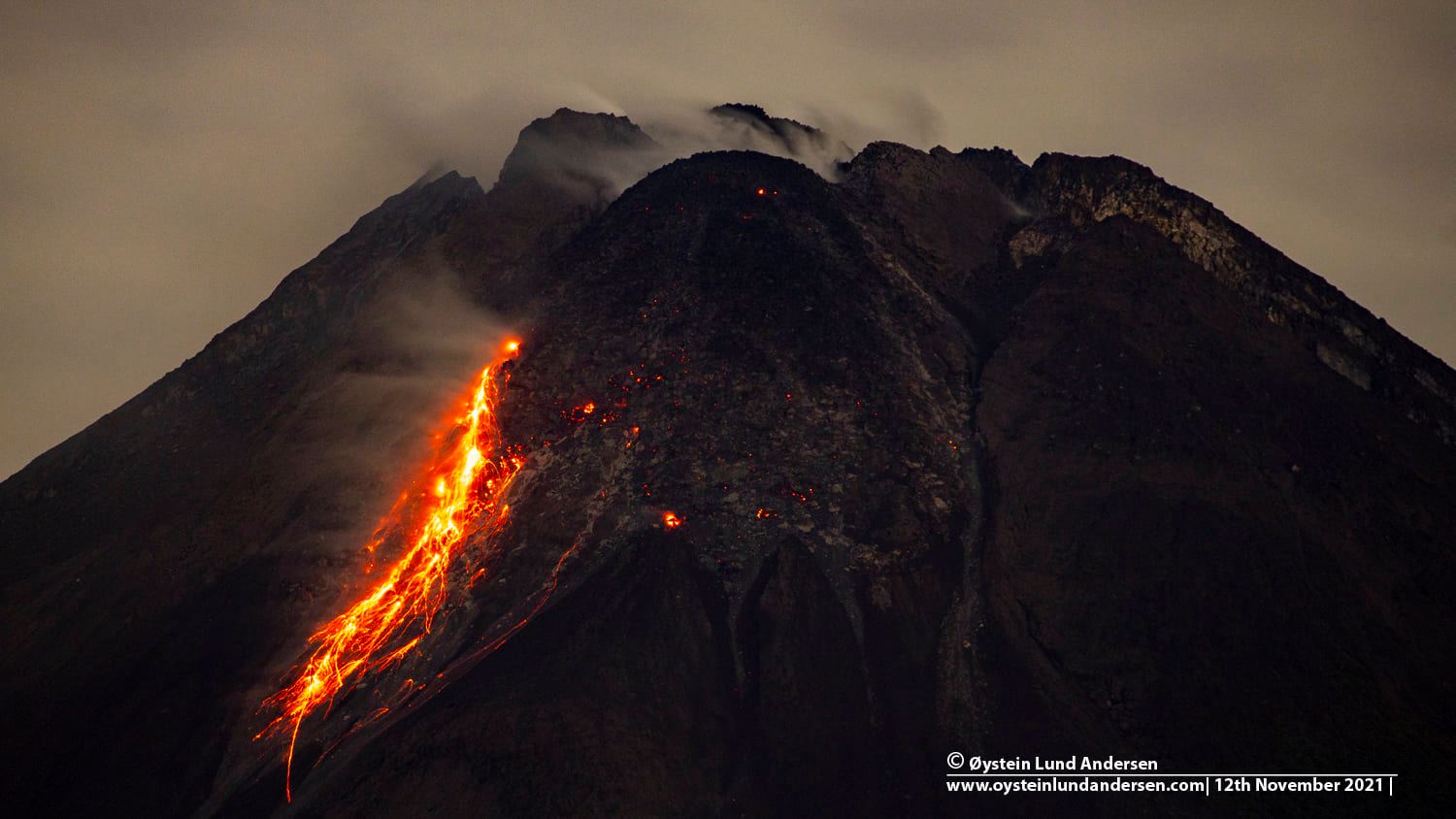
Indonesia , Merapi :
Mount Merapi Activity Report November 12-18, 2021
The weather around Mount Merapi is generally sunny in the morning and evening, while it is foggy in the afternoon.
On November 13, 2021, there was 1 hot cloud avalanche oriented southwest with a sliding distance of 1,800 m. Lava avalanches have been observed 212 times to the southwest with a maximum slide distance of 2000 m.
No significant morphological change was observed in either the southwest dome or the central dome. The volume of the southwest lava dome is 1,610,000 m3 and the central dome is 2,927,000 m3.
– The intensity of the earthquakes this week is still quite high. The deformation of Mount Merapi, which was monitored using EDM this week, showed a distance shortening rate of 0.2 cm / day.
The seismicity of Mount Merapi showed this week:
1 hot cloud avalanche earthquake (AP),
2 shallow volcanic earthquakes (VTB),
128 multi-phase earthquakes (MP),
1,245 avalanche earthquakes s (RF),
384 earthquake emissions (DG),
10 tectonic earthquakes (TT).
The intensity of this week’s seismicity is still quite high.
Conclusion:
1. The volcanic activity of Mount Merapi is still quite high in the form of effusive eruption activity. The status of the activity is defined in the “SIAGA” level.
2. The current potential danger consists of lava avalanches and hot clouds in the South-East-South-West sector over a maximum of 3 km to the Woro river and 5 km to the Gendol rivers, Kuning, Boyong, Bedog, Krasak, Bebeng and Putih. During this time, the ejection of volcanic material in the event of an explosive eruption can reach a radius of 3 km around the summit.
Source : BPPTKG , PVMBG.
Photo : Oystein Lund Andersen
Alaska , Katmai :
58°16’44 » N 154°57’12 » W,
Summit Elevation 6716 ft (2047 m)
Current Volcano Alert Level: NORMAL
Current Aviation Color Code: GREEN
Strong northwesterly winds in the vicinity of Katmai and the Valley of Ten Thousand Smokes have picked up loose volcanic ash erupted during the 1912 Novarupta-Katmai eruption and carried it to the southeast toward Kodiak Island. This resuspension of ash began yesterday morning and continued into the evening yesterday.
This phenomenon is not the result of recent volcanic activity and occurs during times of high winds and dry snow-free conditions in the Katmai area and other young volcanic areas of Alaska. No eruption is in progress. All of the volcanoes of the Katmai area (Snowy, Griggs, Katmai, Novarupta, Trident, Mageik, Martin) remain at color code GREEN.
Resuspended volcanic ash should be considered hazardous and could be damaging to aircraft and health.

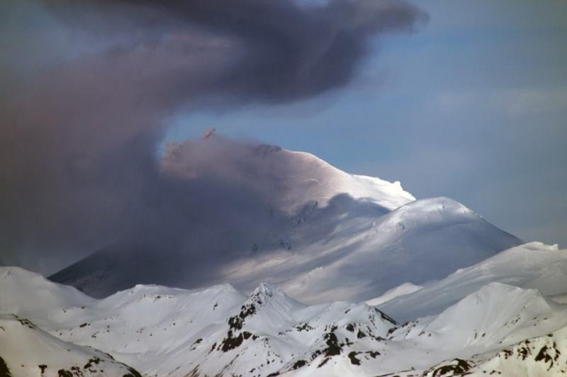
Katmai caldera, a collapse feature that formed during the catastrophic eruption of the nearby Novarupta vent in June 1912 is seen here in an aerial view from the NE. The steep-walled, 1.5-km-wide caldera formed on a cluster of overlapping cones and is partially filled by a lake. Beyond the caldera are the multiple peaks of Trident volcano; Mageik volcano is the snow-and-ice-covered cone in the background.
Prior to 1912, Mount Katmai was a compound stratovolcano with four NE-SW-trending summits, most of which were truncated by caldera collapse in that year. Two or more large explosive eruptions took place from Mount Katmai during the late Pleistocene. Most of the two overlapping pre-1912 Katmai volcanoes are Pleistocene in age, but Holocene lava flows from a flank vent descend the SE flank of the SW stratovolcano into the Katmai River canyon. Katmai was initially considered to be the source of the Valley of Ten Thousand Smokes ash flow in 1912. However, the 3 x 4 km wide caldera of 1912 is now known to have formed as a result of the voluminous eruption at nearby Novarupta volcano. The steep walled young caldera has a jagged rim that rises 500-1000 m above the caldera floor and contains a 250-m-deep, still-rising lake. Lake waters have covered a small post-collapse lava dome (Horseshoe Island) that was seen on the caldera floor at the time of the initial ascent to the caldera rim in 1916. Post-1912 glaciers have formed on a bench within Katmai caldera.
Source : AVO
Photo : Chris Nye, 1991 (Alaska Division of Geological and Geophysical Surveys, Alaska Volcano Observatory).
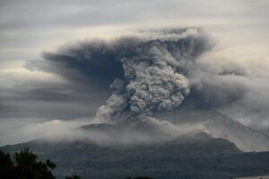
Kamchatka , Karymsky :
VOLCANO OBSERVATORY NOTICE FOR AVIATION (VONA)
Issued: November 20 , 2021
Volcano: Karymsky (CAVW #300130)
Current aviation colour code: ORANGE
Previous aviation colour code: orange
Source: KVERT
Notice Number: 2021-149
Volcano Location: N 54 deg 2 min E 159 deg 26 min
Area: Kamchatka, Russia
Summit Elevation: 1486 m (4874.08 ft)
Volcanic Activity Summary:
The eruptive activity of the volcano continues. Satellite data showed explosions sent ash up to 5.4 km a.s.l., and ash cloud 11×8 km in size to drift for 115 km to the north-west of the volcano.
This activity continues. Ash explosions up to 10 km (32,800 ft) a.s.l. could occur at any time. Ongoing activity could affect international and low-flying aircraft.
Volcanic cloud height:
5400 m (17712 ft) AMSL Time and method of ash plume/cloud height determination: 20211120/0011Z – NOAA 18 (4m5)
Other volcanic cloud information:
Distance of ash plume/cloud of the volcano: 115 km (71 mi)
Direction of drift of ash plume/cloud of the volcano: NNW / azimuth 327 deg
Time and method of ash plume/cloud determination: 20211120/0011Z – NOAA 18 (4m5)
Source : Kvert.
Photo : RIA Novosti Alexandre Piragis
Iceland , Hekla :
Ongoing earthquake swarm in Vatnafjöll mountain south of Hekla volcano
The earthquake activity south of Hekla volcano is ongoing and the largest earthquakes in recent days have had a magnitude of Mw3,8 and Mw3,3. Other earthquakes in recent days have been smaller. The largest earthquakes have been felt in nearby farms and Hvolvollur town and in Hella town.
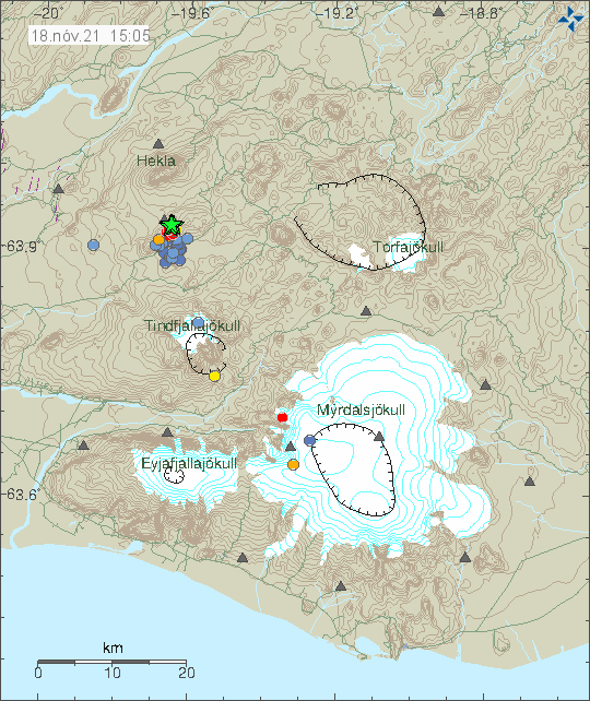
Green stars south of Hekla volcano show the location of the earthquake swarm. A lot of blue dots show the many earthquakes that have happened there in last 48 hours. Copyright of this image belongs to Icelandic Met Office.
In the last few days it looks like the earthquake activity has been moving slight north and it is unclear why that is happening. No changes have been observed in Hekla volcano, there was a minor earthquake swarm in Hekla volcano few days ago but that did not result in anything. There continues to be a risk of a strong earthquake in this area.
Four earthquakes over M3 were detected the 18th of November, in Vatnafjöll. Largest earthquake measured were M3.8 at 13:21. These earthquakes are a part of a seismic swarm that started on the 11th of November.
Sources : icelandgeology.net / JÓN FRÍMANN , Vedur is.
Alaska , Pavlof :
55°25’2″ N 161°53’37 » W,
Summit Elevation 8261 ft (2518 m)
Current Volcano Alert Level: WATCH
Current Aviation Color Code: ORANGE
The eruption at Pavlov continues. Tremor and explosions were detected throughout the week in seismic and infrasound data. Ballistic blocks on the volcano’s upper flanks were observed in satellite data, but explosions during the week resulted in limited ash emissions.
Starting Sunday, November 14, low-level lava fountaining from the vent on the upper southeast flank has built a small cone of hot unstable debris. Debris from the cone has formed hot flows that extend a few hundred meters below the vent. These flows melt snow and ice, and the meltwater combines with debris to form thin, watery lahars that extend down the flank for several kilometers. Elevated surface temperatures have been observed in satellite data since Sunday, suggesting that this activity continues.
The level of unrest at Pavlof can change quickly and the progression to more significant eruptive activity can occur with little or no warning.
Pavlof is monitored by local seismic and infrasound sensors, satellite data, web cameras, and remote infrasound and lightning networks.
Source : AVO.
Photo : Snapp, Royce