July 29 , 2021 .
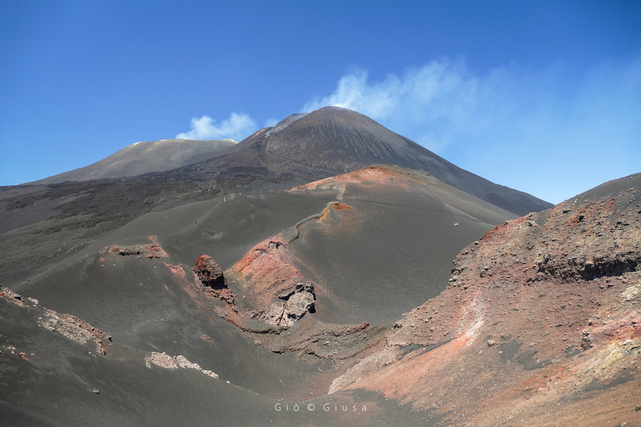
Italy / Sicily , Etna / Stromboli :
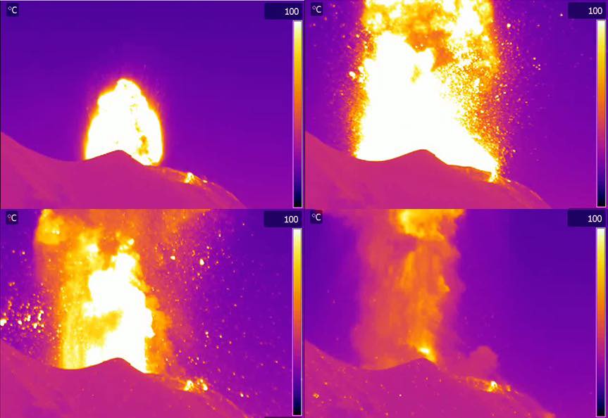
Press release on ETNA’s activity, July 28, 2021, 10:30 am (08:30 UTC).
The National Institute of Geophysics and Volcanology, Osservatorio Etneo, announces that from 07:25 UTC, a resumption of Strombolian activity is observed at the level of the Southeast Crater. The activity is currently confined to the crater and generates discontinuous and light ash emissions which are dispersed in the summit area.
The average amplitude of the volcanic tremor showed a sudden increase from 07:40 UTC reaching high values. A gradual return to average values is currently observed. The source of the tremor is located in correspondence with the craters of Bocca Nuova and the Southeast Crater at an altitude of about 2800 m above sea level.
The infrasound activity is increasing and is located in the Southeast Crater.
At present, the deformation signals from permanent GNSS and inclinometric networks do not show significant changes.
Press release on the activity of STROMBOLI, July 28, 2021, 10:30 (08:30 UTC).
The National Institute of Geophysics and Volcanology, Osservatorio Etneo, announces that at 14:47 UTC the monitoring network recorded an explosive event energetically more intense than usual in the Central / Center-South sector of the crater terrace. The products of the explosive activity dispersed radially in the area of the crater terrace with relapse along the Sciara del Fuoco and the Pizzo area.
Seismically, the explosive event at 14:47 UTC is clearly visible at all seismic stations in Stromboli. Regarding the amplitude of the volcanic tremor, an increase was observed from 14:00 UTC. Currently, the amplitude of the tremor is on medium-high values.

No significant variation is observed in the distortion signals of the GPS and inclinometric networks of Stromboli.
Further updates will be communicated shortly.
Source : INGV
Photos : Gio Giusa , LGS
Alaska , Gareloi :
AVO/USGS Volcanic Activity Notice
Current Volcano Alert Level: NORMAL
Previous Volcano Alert Level: AVIS
Current Aviation Color Code: GREEN
Previous Aviation Color Code: YELLOW
Issued: Wednesday, July 28, 2021, 11:33 AM AKDT
Source: Alaska Volcano Observatory
Notice Number: 2021/A569
Location: N 51 deg 47 min W 178 deg 47 min
Elevation: 5161 ft (1573 m)
Area: Aleutians
Volcanic Activity Summary:
The increase in seismic activity observed in May and June, 2021 at Mount Gareloi (Gareloi volcano) has diminished. Because the level of seismic activity is now at background, AVO is returning the aviation color code to GREEN and the Volcano Alert Level to NORMAL.
Gareloi is monitored by a local seismic and infrasound network, satellite data, and regional infrasound and lightning-detection networks.
Recent Observations:
[Volcanic cloud height] None
[Other volcanic cloud information] n/a
Remarks:
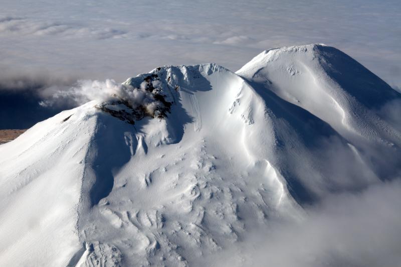
Mount Gareloi, which makes up all of Gareloi Island, is a stratovolcano located in the Delarof Islands group of the Aleutian Islands, about 2,000 km (1,242 mi) west-southwest of Anchorage and about 150 km (93 mi) west of Adak, the westernmost community in Alaska. This small volcano is 10 × 8 km (6.2 × 5.0 mi) in diameter at its base with two summits, separated by a narrow saddle. The northern, slightly higher peak contains crater about 300 m (1,000 ft) across. The southern summit has a crater open to the south and a persistent degassing vent (fumarole) on its western rim. Gareloi has been one of the most active in the Aleutians since the 1740s, with 16 reports of eruptive activity at Gareloi since 1760. In 1929, its largest historical eruption produced sixteen small south- to southeast-trending craters that extend from the southern summit to the coast, as well as lava flows and pyroclastic deposits on the southeastern flank of the volcano. Eruptions of Gareloi commonly produce ash clouds and lava flows, and the primary hazard is airborne clouds of ash that could affect aircraft. Since seismic instruments were installed in 2003, they have detected small but consistent seismic signals from beneath Mount Gareloi’s edifice.
Source : AVO
Photo : , Read, Cyrus
Kamchatka , Ebeko :
VOLCANO OBSERVATORY NOTICE FOR AVIATION (VONA)
Issued: July 28 , 2021
Volcano: Ebeko (CAVW #290380)
Current aviation colour code: ORANGE
Previous aviation colour code: orange
Source: KVERT
Notice Number: 2021-76
Volcano Location: N 50 deg 41 min E 156 deg 0 min
Area: Northern Kuriles, Russia
Summit Elevation: 1156 m (3791.68 ft)
Volcanic Activity Summary:
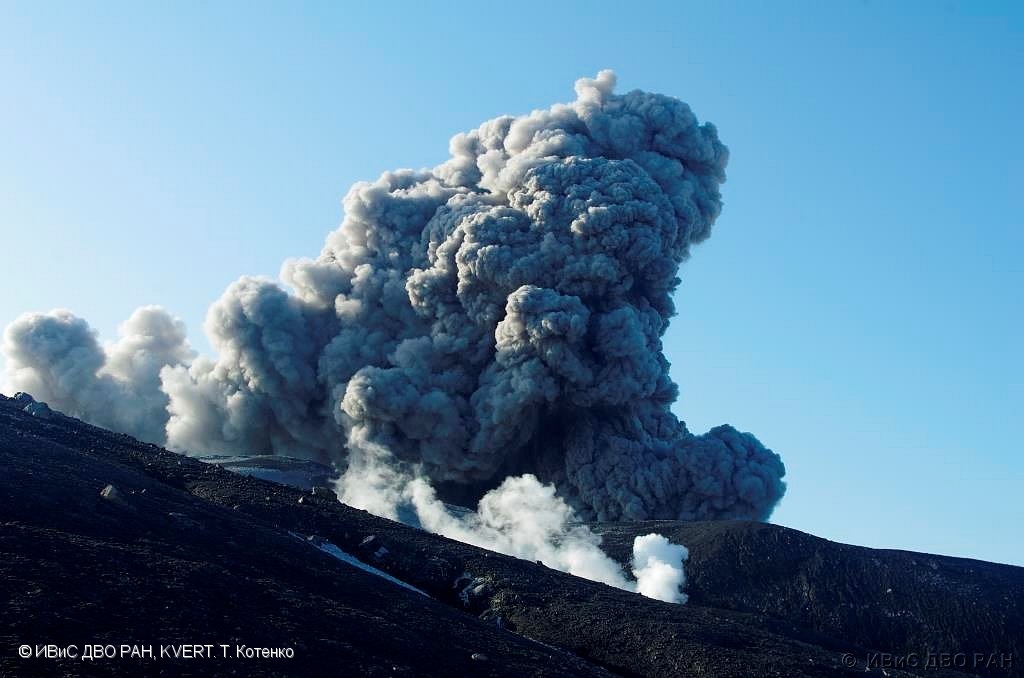
A moderate eruptive activity of the volcano continues. According to visual data by volcanologists from Severo-Kurilsk, an explosion sent ash up to 2 km a.s.l., an ash cloud is drifting to the south of the volcano.
This activity continues. Ash explosions up to 6 km (19,700 ft) a.s.l. could occur at any time. Ongoing activity could affect low-flying aircraft and airport of Severo-Kurilsk.
Volcanic cloud height:
2000 m (6560 ft) AMSL Time and method of ash plume/cloud height determination: 20210728/2248Z – Visual data
Other volcanic cloud information:
Distance of ash plume/cloud of the volcano: 10 km (6 mi)
Direction of drift of ash plume/cloud of the volcano: S
Time and method of ash plume/cloud determination: 20210728/2248Z – Visual data
Source : Kvert
Photo : T. Kotenko,
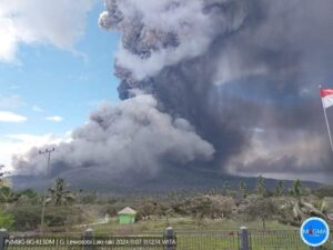
Indonesia , Sinabung :
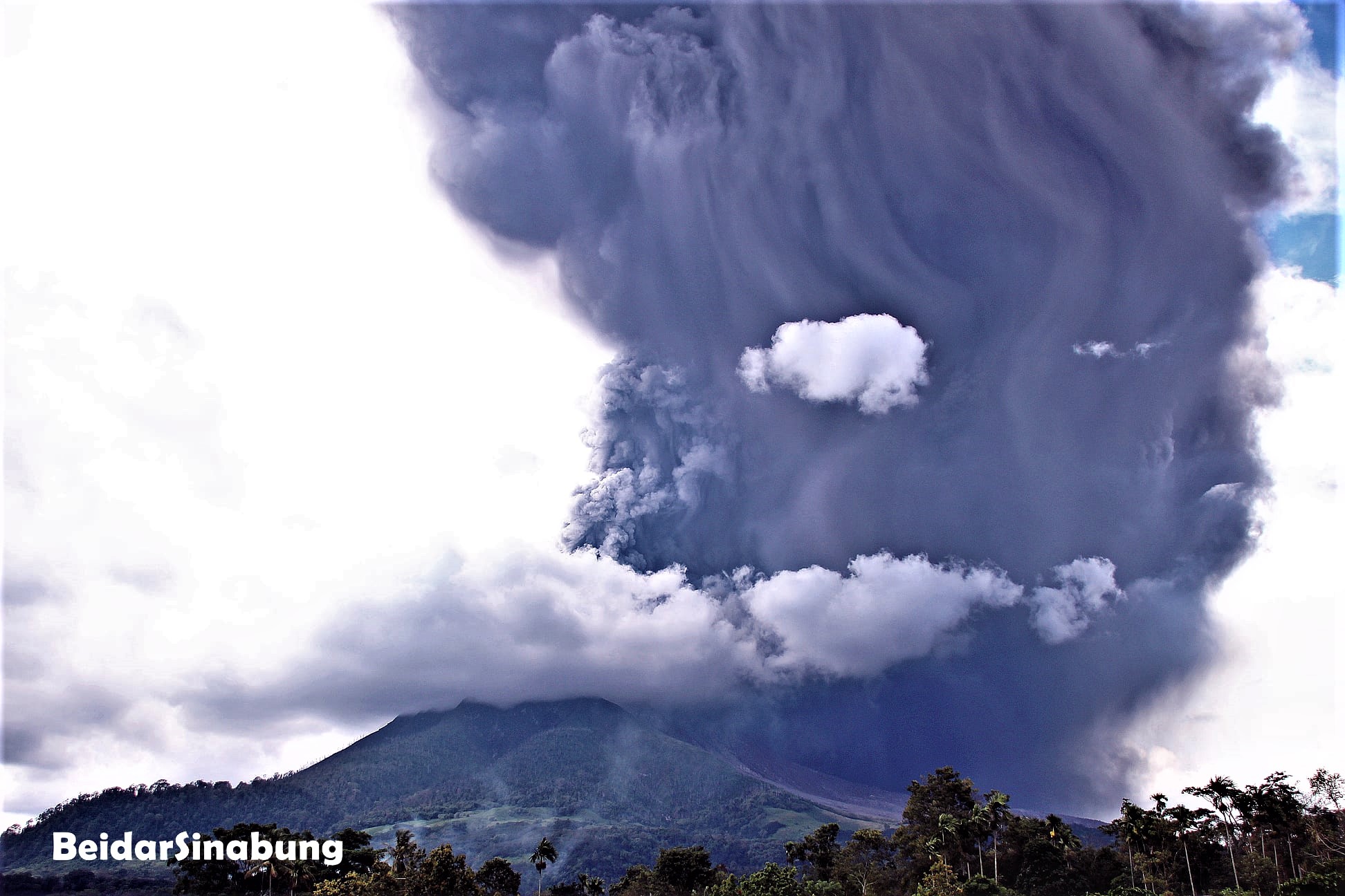
Mount Sinabung eruption on July 28, 2021 – North Sumatra, July 29, 2021.
Mount Sinabung in Karo Regency, North Sumatra Province, has been erupting intermittently since 2013. The character of the eruption is an explosive eruption accompanied by the formation of a lava dome at the top. The level of activity has been level III (SIAGA) since May 20, 2019.
From July 1 to 19, 2021, there were 4 (four) eruptions resulting in an eruption column with a height of 700 to 1000 m. On July 28, 2021, at 1:20 p.m. WIB, an eruption occurred with an ash column 4500 m above sea level, recorded on the seismogram as an eruption earthquake with an amplitude of 120 mm and a duration of 742 seconds.
This eruption was followed by hot eruption clouds with a sliding distance of 1000 m to the east and 1000 m to the south-east, with prevailing wind directions in the east and south. There was heavy ash rains in the eastern sector of Mount Sinabung (Namanteran, Merdeka and Berastagi sub-districts). Light ash rain – currently occurring in Simpang Empat district.
Analyse:
The eruption event of July 28, 2021 is characteristic of the eruption of Mount Sinabung which has occurred since 2013. The eruption symptom is characterized by an increase in hybrid and volcanic earthquakes in a few days since the 23 July 2021.
Visual observations and seismicity up to July 28, 2021 at 7:00 p.m. WIB showed fluctuations. After the eruption, tremors and hybrid earthquakes were recorded, indicating that the magma supply was still occurring. At 2 o’clock in the afternoon. 18:30 WIB a mudslide occurs in the eastern sector of Mount Sinabung.
Potential danger:
Explosive eruptions still have the potential to occur, but the threat is still within the recommended range at Level III (SIAGA).
Eruption events, hot avalanche clouds, hot eruption clouds and rock avalanches (incandescent lava) have the potential to occur, covering the South, East to South-East sectors in a radius of 4 to 5 km, while blowout material (ash) may be carried further depending on wind direction and speed.
Lahars have the potential to occur in the river valleys that originate on Mount Sinabung, mainly due to heavy rainfall.
Conclusion:
Based on the results of visual and instrumental observations up to July 28, 2021, it is estimated that the level of volcanic activity of Mount Sinabung is still at level III (SIAGA).
Source : PVMBG.
Photo : Beidar Sinabung.
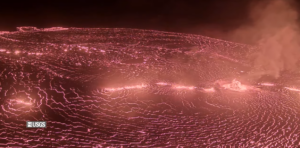
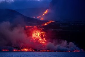
Iceland , Geldingadalur / Fagradalsfjall :
The fissure eruption in the W part of the Krýsuvík-Trölladyngja volcanic system, close to Fagradalsfjall on the Reykjanes Peninsula, continued during 21-27 July. Lava fountaining and overflows from the fifth vent were periodically visible, in between long pauses in the eruption, and lava from the crater flowed in tubes as well as on the surface.
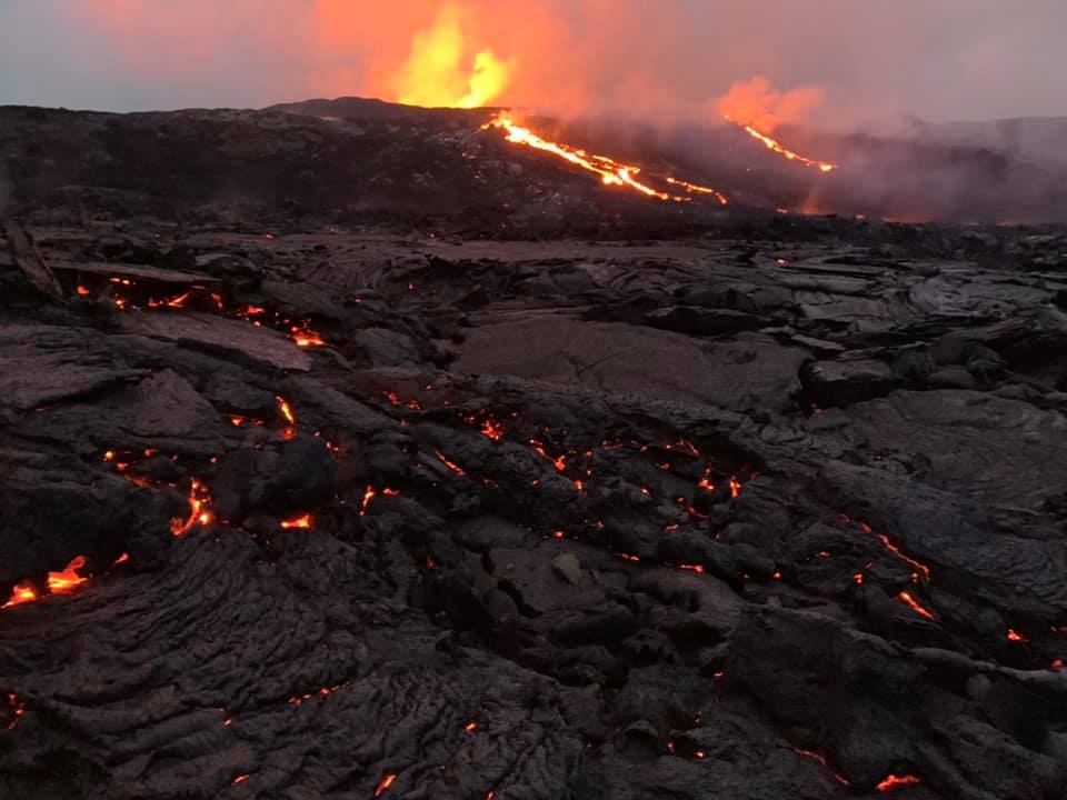
The Institute of Earth Sciences noted that during 2-19 July the lava effusion rate averaged 7.5 cubic meters per second, which was notably lower than averages in May and June. The area of the flow field had grown to almost 4 square kilometers, and the total volume erupted was 96 million cubic meters. Lava flowed into the Meradalir Valley and areas to the W, but did not advance in the Geldingadalur, Nátthaga, and Sydri Meradalir (SE of the fifth vent) valleys. The Aviation Color Code remained at Orange due to the lack of ash and tephra emissions, though IMO warned of the potential for lapilli and scoria fallout within a 650 m radius of the active vent. Authorities warned of increased gas emissions hazards.
Source : GVP
Photo : Petur Thor via Alicja Szojer
Japan , Suwanosejima :
JMA reported ongoing explosions at Suwanosejima’s Ontake Crater during 19-26 July and that crater incandescence was visible on some nights. There were 31 explosions recorded on 22 July after two days of no explosions.
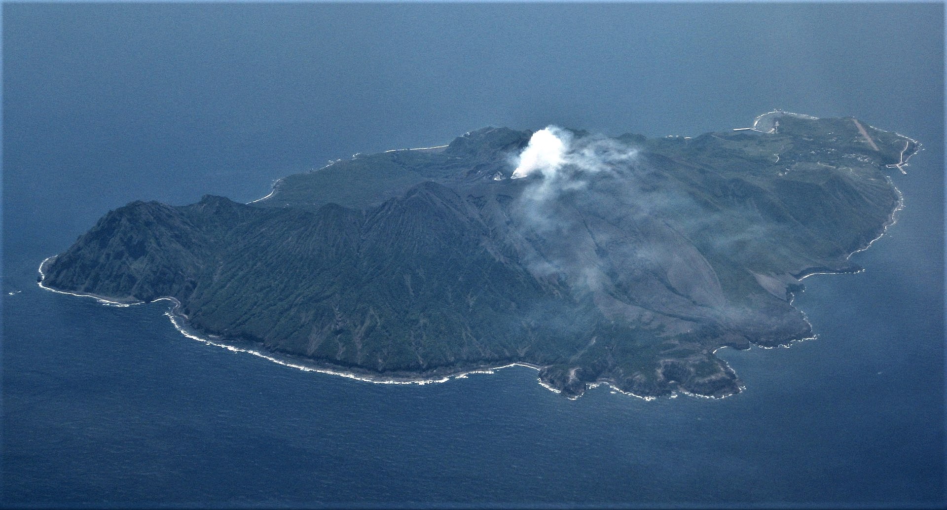
An explosion at 1500 on 23 July produced an ash plume that rose 1.6 km and ejected bombs 200 m. Eruption plumes during 23-26 July rose as high as 2.3 km; it was unknown if bombs were ejected from the crater due to weather conditions. The Alert Level remained at 3 and the public was warned to stay 2 km away from the crater.
Source: Japan Meteorological Agency (JMA) , , GVP.
Photo : Ray Go.