July 18 , 2021 .
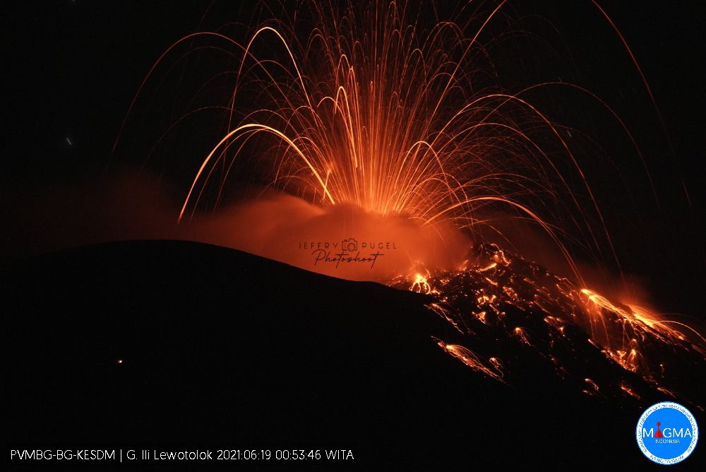
Indonesia , Ili Lewotolok :
Level of activity at level III (Siaga) since November 29, 2020 at 1:00 p.m. WITA. This increase in status was motivated by an eruption on November 27, 2020 at 05:57 a.m. WITA with a height of gray to black ash columns observed at 500 m above the peak (1923 m altitude) with a thick intensity, oriented towards the west. This eruption was recorded on a seismogram with a maximum amplitude of 34 mm. The duration of the eruption was not clearly observed as it was followed by continuous tremors. Eruptions still occur today. The volcano is clearly visible until it is covered in fog. The smoke from the main crater is white, gray and black with moderate to thick intensity, about 300-1000 meters above the summit. The weather is sunny to cloudy, the wind is weak to strong in the Northeast and West. There was a low to moderate rumbling sound and a moderate to loud explosion sound, an eruption was observed accompanied by a maximum incandescent ejection up to 350 meters in all directions and in the South-East up to 500 meters from the center of the eruption.
According to the seismographs of July 17, 2021, it was recorded:
11 eruption earthquakes / explosions
26 emissions earthquakes
33 non-harmonic tremor signals.
VOLCANO OBSERVATORY NOTICE FOR AVIATION – VONA
Issued : July 14 , 2021
Volcano : Ili Lewotolok (264230)
Current Aviation Colour Code : ORANGE
Previous Aviation Colour Code : orange
Source : Ili Lewotolok Volcano Observatory
Notice Number : 2021LEW27
Volcano Location : S 08 deg 16 min 19 sec E 123 deg 30 min 18 sec
Area : East Nusa Tenggara, Indonesia
Summit Elevation : 4554 FT (1423 M)
Volcanic Activity Summary :
Eruption with volcanic ash cloud at 22h18 UTC (06h18 local). Eruption and ash emission is not continuing.
Volcanic Cloud Height :
Best estimate of ash-cloud top is around 7114 FT (2223 M) above sea level, may be higher than what can be observed clearly. Source of height data: ground observer.
Other Volcanic Cloud Information :
Ash-cloud moving to Northwest
Remarks :
Seismic activity is characterized by continuous volcanic tectonik earthquake.
Source : PVMBG. Magma Indonésie .
Photo : Jeffry Pugel /PVMBG – Magma Indonesia
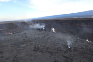
Hawaii , Kilauea :
19°25’16 » N 155°17’13 » W,
Summit Elevation 4091 ft (1247 m)
Current Volcano Alert Level: ADVISORY
Current Aviation Color Code: YELLOW
Activity Summary:
Kīlauea Volcano is not currently erupting. No surface activity has been observed by field crews or in webcam images since May 23, 2021. Seismicity has slowly increased in recent weeks in the summit region, with continued summit inflation over the past several months. Sulfur dioxide emission rates remain slightly elevated. It is possible that the Halema‘uma‘u vent could resume eruption or that Kīlauea is entering a longer period of quiescence prior to the next eruption.
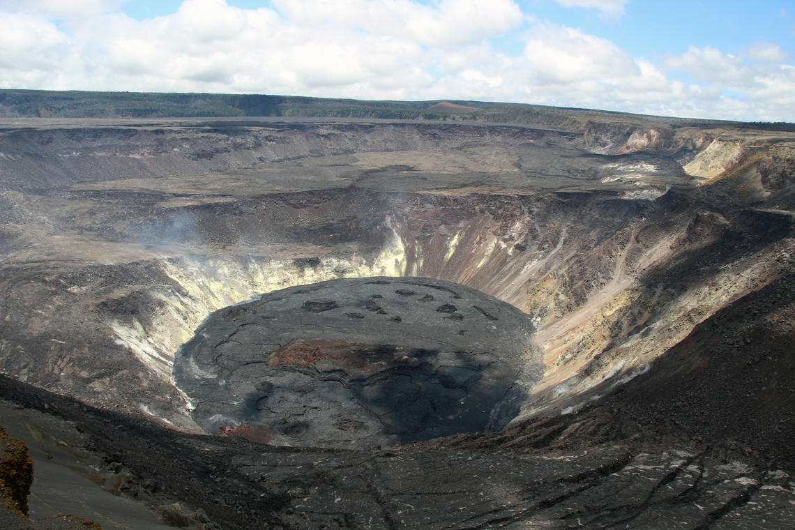
Summit Observations:
The most recent sulfur dioxide (SO2) emission rate, measured on July 6, 2021, was 70 tonnes per day (t/d). SO2 emission rates have been approaching levels associated with the non-eruptive period from late 2018 to late 2020 (30-35 t/d) and are significantly lower than emission rates that averaged over 800 t/d from mid-February to mid-April. Summit tiltmeters recorded two deflation-inflation cycles over the past week, along with continued gradual inflation. Continued inflation was also recorded by summit GPS instruments; however, the pattern of tilt and GPS motions indicates that the inflation center may have shifted slightly to the southern part of the caldera. Seismicity has been slowly increasing in recent weeks, though it has not yet reached levels seen immediately prior to the December 2020 eruption.
Halemaʻumaʻu Lava Lake Observations:
The lake’s surface is completely covered by solidified lava crust. No surface activity or evidence of recent surface activity has been observed over the past week. Near-real time webcam views of the lava lake can be found in the webcam link below.
East Rift Zone Observations:
No unusual activity noted in the region. Geodetic monitors indicate that the summit and upper East Rift Zone—between the summit and Puʻuʻōʻō—is refilling at rates similar to those measured over the past 2 years and before the December 2020 eruption. SO2 and hydrogen sulfide (H2S) emissions from Puʻuʻōʻō were below instrumental detection levels when last measured on January 7, 2021.
Source : HVO.
Photo : D. Downs.
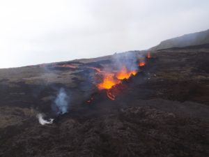
Ecuador , Reventador :
DAILY REPORT OF THE STATE OF THE REVENTADOR VOLCANO, Saturday July 17, 2021.
Information Geophysical Institute – EPN.
Surface activity level: High, Surface trend: No change.
Internal activity level: Moderate, Internal trend: No change.
Seismicity: From July 16, 2021, 11:00 a.m. to July 17, 2021, 11:00 a.m.
Explosions (EXP): 32 events
Long period type events (LP): 43
Emission tremor (TREMI): 8.
Harmonic Tremor (TRARM): 1.
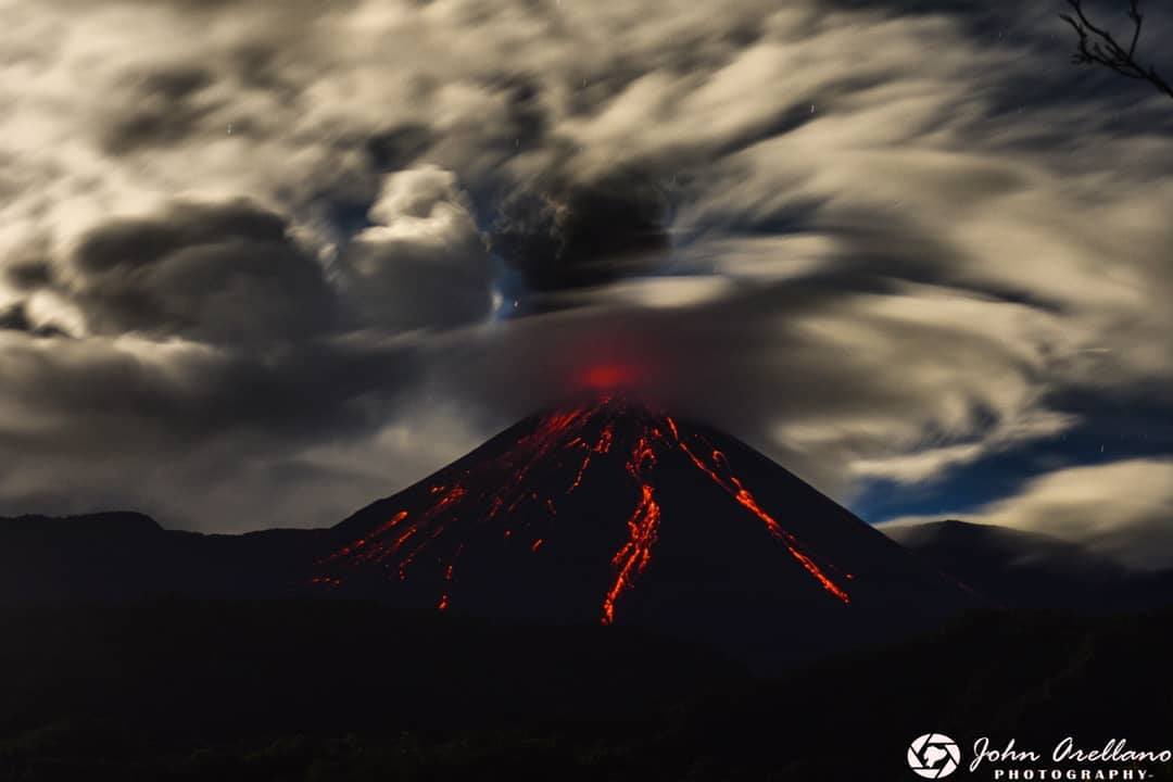
Rains / lahars: Light rains were recorded in the volcano region, without generating lahars.
Emission / ash column: No emission was observed by the cameras. However, the VAAC recorded 2 ash emission alerts observed by satellites 1400 meters above crater level in a westerly direction.
Other monitoring parameters: No thermal alerts have been recorded in the last 24 hours.
Observations: Last night, an incandescence was observed in the crater and on thermal camera images of the active lava flow on the northeast flank of the volcano. During the morning the area remained cloudy
Alert level: Orange.
Source : IG-EPN
Photo : John Arellano
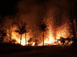
Guatemala , Santiaguito :
ACTIVITY:
The seismic stations recorded weak to moderate avalanches which affected the southwest and west flanks of the Caliente dome, as well as mostly weak explosions, which generated outgassing and ash at a height of up to 3,500 meters (11,482 feet). The avalanches reach the base of the Caliente dome and cause the fall of fine particles of ash on the volcanic perimeter.

Due to the permanent extrusion of lava in blocks from the Caliente dome, in a west-southwest direction, there is constant incandescence and long periods with slight outgassing. The occurrence of additional boulder and ash avalanches in this same direction, as well as possible long-range pyroclastic flows in different directions, are not excluded. For short periods, it is possible to hear sounds similar to those of an airplane turbine, due to prolonged degassing on the Caliente dome.
Source : Insivumeh.
Photo : Conred.
Iceland , Geldingadalur / Fagradalsfjall :
Update on the eruption in Fagradalsfjall on Saturday 17-July-2021
Since 9th July the eruption has been unstable. Between 10th July and 15th of July the eruption continued as before with pulsing activity.
On 15th of July at 05:00 the eruption stopped and it didn’t start again until around 10:00 on 16th of July.
At the writing of this article it seems that the eruption has stopped again based on the harmonic tremor.
The lava flows is down in Meradalir when the lava flow happens. At current rate it is going to take 1 to 4 weeks until Merdalir overflows with lava into next valley.
The east side of the crater has collapsed and that allows the lava flow direct flow down into Meradalir.
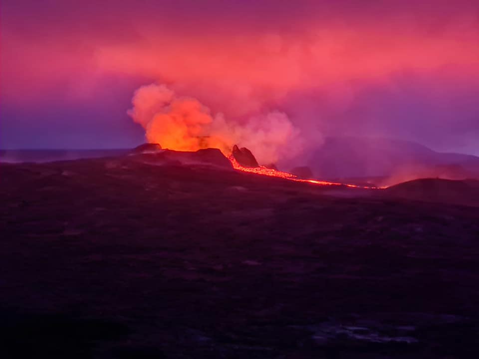
It is unclear why the eruption stops and starts. One idea is that the eruption’s deep feed system is now empty and needs time to refill. The rash stops when the feeding system is empty. The more empty it is, the longer the eruption stops because it takes longer for the magma to fill the magma chamber which seems to be there 20 km or more deep. It is impossible to know how long it will last, but it cannot last for months or years. The current crater will at some point seal and the eruption will stop because of it.
Source : icelandgeology.net
Read the article: https://icelandgeology.net/?fbclid=IwAR2lXUya158aMGGqJjNsIYWgJjHDuOUQlom1co7V75FwsWU4_-Pd_hdGexk
Photo : Matan Fidel .