23 Avril 221 .
Indonesia , Merapi :
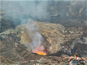
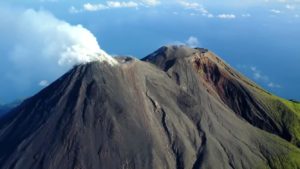
Level of activity at level III (SIAGA) since November 5, 2020 at 12:00 WIB. The Merapi volcano (2968 m above sea level) is continuously erupting. The last eruption took place on March 27, 2021 with a height of the eruption column 500 m above the peak. It was observed that the color of the ash column was gray.
The volcano was clearly visible until it was covered in fog. The smoke from the crater was observed to be white with a strong intensity, rising about 300 meters from the top of the summit. The weather is sunny to cloudy, weak to moderate winds in the North and Northwest.
According to the seismographs of April 21, 2021, it was recorded:
• 1 hot cloud avalanche earthquake.
• 123 avalanche earthquake
• 2 earthquakes of emissions
• 9 hybrid / multi-phase earthquakes
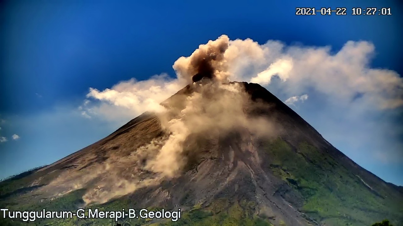
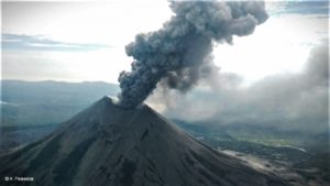
The Merapi hot cloud avalanche on April 22, 2021 at 10.27 WIB was recorded on a seismogram with an amplitude of 35 mm and a duration of 122 seconds. Maximum sliding distance of 1500 m to the southwest. The wind is blowing in the east.
Another hot cloud avalanche over the Merapi occurred on April 23, 2021 at 11:20 a.m. WIB and was recorded on a seismogram with an amplitude of 55 mm and a duration of 125 seconds. Slide distance of 2000 m to the South-West. The wind is blowing in the east, the height of the column has been observed at 300 m above the summit.
Source : BPPTKG.
Alaska , Semisopochnoi :
VOLCANO OBSERVATORY NOTICE FOR AVIATION (VONA).
Issued: April 22 , 2021
Current Color Code: ORANGE
Previous Color Code: ORANGE
Source: Alaska Volcano Observatory
Notice Number: 2021/A188
Volcano Location: N 51 deg 55 min E 179 deg 35 min
Area: Aleutians
Summit Elevation: 2625 ft (800 m)
Volcanic Activity Summary:
Eruptive activity at Semisopochnoi has gradually increased over the last 24 hours. Satellite views of the volcano show a continuous plume extending 50 miles (80 km) to the south at approximately 8000 feet a.m.s.l. A regional infrasound array has detected this increase in activity. The aviation color code and alert level remain at ORANGE/WATCH; however, AVO will continue to monitor the activity with satellite and regional infrasound data.
Small eruptions producing minor ash deposits within the vicinity of the volcano and ash clouds under 10,000 ft above sea level are typical of activity at this volcano.
Volcanic cloud height:
8000 ft a.m.s.l.
Other volcanic cloud information:
unknown
Remarks:
Semisopochnoi is monitored by satellite data, regional infrasound, and lightning detection instruments. An infrasound array on Adak Island may detect explosive emissions from Semisopochnoi with a slight delay (approximately 13 minutes) if atmospheric conditions permit.
Source : AVO
Photo : Kaufman, Max.
Saint Vincent , Soufrière Saint Vincent :
La Soufrière, St. Vincent – SCIENTIFIC UPDATE 22/04/21 6:00PM
– Seismic activity at La Soufrière continued the pattern established after the explosive activity on 18 April.
– Small long-period and hybrid earthquakes continued to be recorded, with their rate of occurrence gradually increasing.
– High-level seismic tremor started at 11:09 am, generated by explosive activity, and lasted for about 20 minutes.
– A vertical explosive eruption plume rose slowly above the crater eventually reaching a height of about 8 km.
– During the initial stages of the explosion, a base surge (pyroclastic density current, PDC) was seen moving down the western flank of the volcano. PDCs are hot (200°C-700°C), ground-hugging flows of ash and debris.
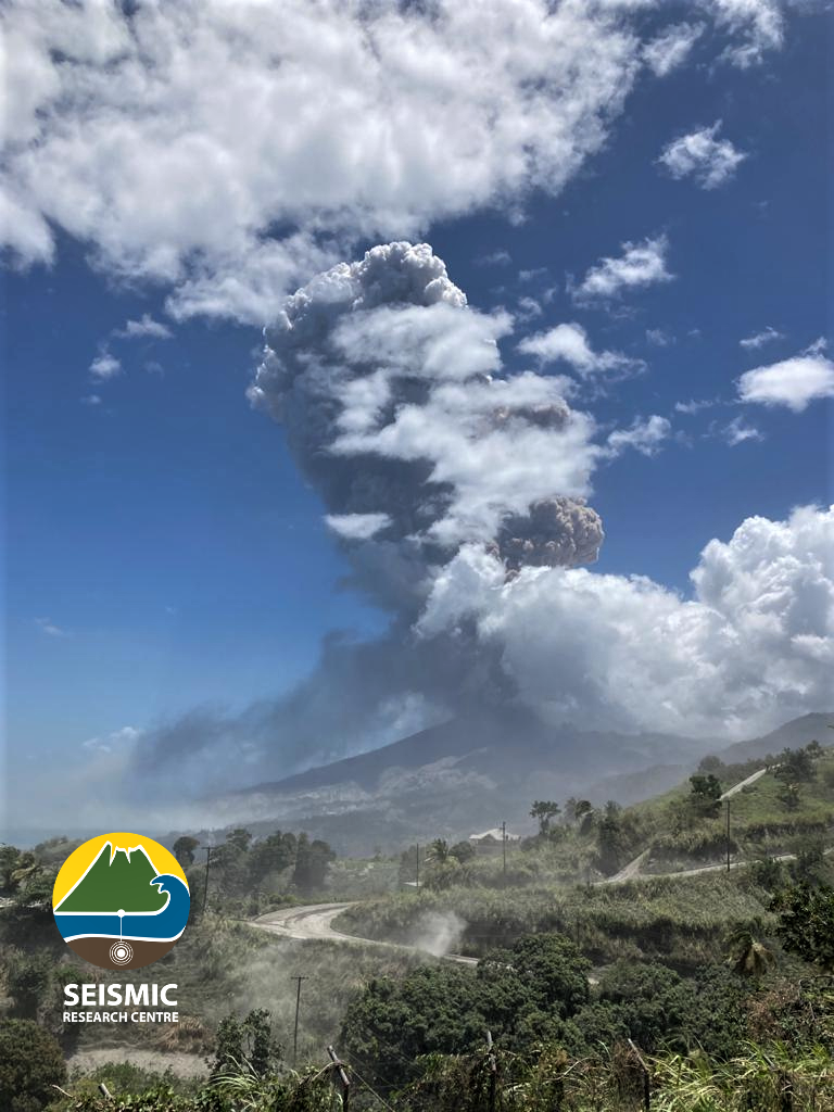
The view from the observatory at 11:08 am this morning. Explosions can happen without warning during the ongoing eruption. It has now risen to above 8km into the atmosphere. Most of the material seems to be going out towards the Caribbean sea. The south and neighboring islands will not be affected. We continue to monitor and will update accordingly.
Photo credit: Richard Robertson, UWI-SRC
– Tremor continued, at a lower level, for the next two hours as La Soufrière continued to vent ash.
– Since the initial depressurization noted immediately following the April 9 explosive phase, the continuous GPS network has recorded a decrease in the overall rates of horizontal and vertical
movement.
– The continuous GPS (Global Positioning System) network is used to track changes in ground shape on and around the volcano. As magma moves beneath the volcano, changes in pressure cause the volcano to change shape (inflate/deflate).
– The volcano continues to erupt. Its pattern of seismic activity over the last few days is typical of the growth and destruction of lava domes.
– Explosions with accompanying ashfall, of similar or larger size, can occur with little or no warning impacting St. Vincent and neighbouring islands.
– The volcano is at alert level Red.
Source : UWI
Photo: Richard Robertson, UWI-SRC
Hawaii , Kilauea :
19°25’16 » N 155°17’13 » W,
Summit Elevation 4091 ft (1247 m)
Current Volcano Alert Level: WATCH
Current Aviation Color Code: ORANGE
Activity Summary:
Kīlauea Volcano is erupting. Lava activity is confined to Halemaʻumaʻu with lava erupting from a vent on the northwest side of the crater. This morning, April 22, the lava lake was 226 m (741 ft) deep and remains stagnant over its eastern half. SO2 emission rates remain elevated at 950 t/day, last measured on April 14.
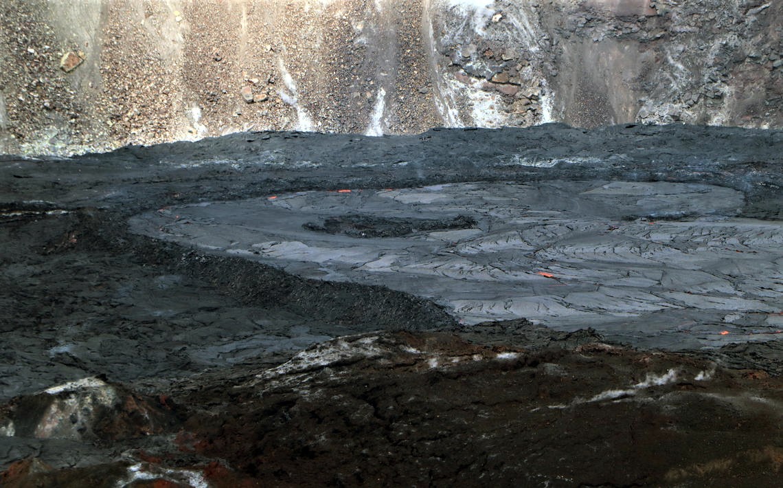
A view of the south margin of the perched lava lake in Halema‘uma‘u Crater, at the summit of Kīlauea. This photo was taken from the east rim of the crater, and shows the steep levee containing the lake. USGS photo by M. Patrick.
Summit Observations:
The most recent sulfur dioxide emission rate, measured on April 14, was 950 t/day. This is elevated compared to rates in the months before the eruption started on December 20 (less than 100 t/day), but lower than emission rates from the pre-2018 lava lake (around 5,000 t/day). Summit tiltmeters recorded minor change over the past 24 hours. Seismicity remains stable, with elevated tremor.
East Rift Zone Observations:
No unusual activity noted in the region. Geodetic monitors indicate that the summit and upper East Rift Zone—between the summit and Puʻuʻōʻō—is refilling at rates similar to those measured over the past 2 years and before the December 2020 eruption. SO2 and H2S emissions from Puʻuʻōʻō were below instrumental detection levels when last measured on January 7.
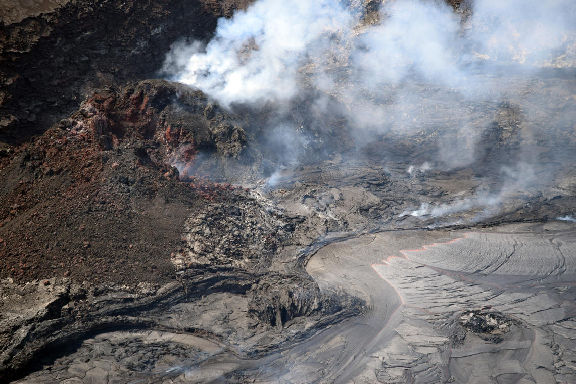
A telephoto view of the west vent and lava lake inlet within Halema‘uma‘u crater at the summit of Kīlauea. Lava erupting from the west vent (upper left) continues to feed into the active lava lake through a wide inlet near the base of the cone (center right). This photo was taken from the south rim of Halema‘uma‘u crater, in an area of Hawai‘i Volcanoes National Park that remains closed to the public due to safety reasons. USGS photo taken by L. DeSmither on April 20, 2021.
Halemaʻumaʻu lava lake Observations:
Lava effusion from the west vent continues to supply the lava lake within Halema‘uma‘u crater. The west vent is consistently effusing lava at a low rate through a submerged inlet to the lake. Lava circulation and intermittent foundering of crust continue in the western portion of the lava lake, with lava oozing out sporadically in areas along the perimeter of the lake. The total depth of the lake is 226 m (741 ft) this morning as measured by a continuous laser rangefinder on the active western portion of the lake. Stagnant and solidified lava crust covers the eastern portion of the lava lake and is slowly growing westward.
Source : HVO.