April 21 , 2020 .
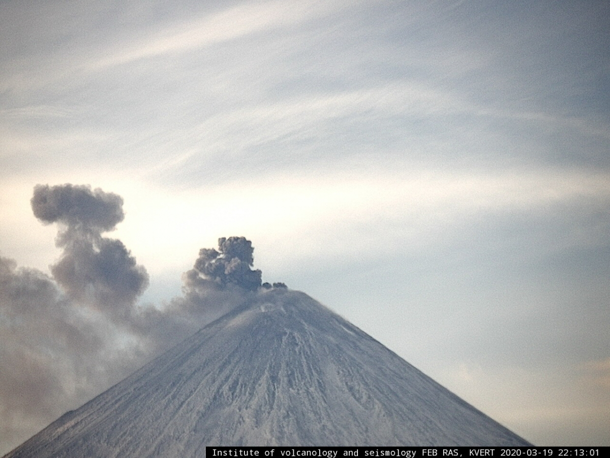
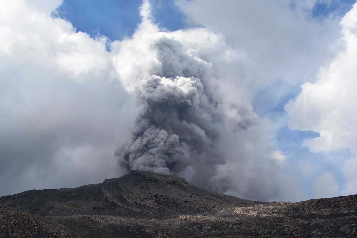
Kamchatka , Klyuchevskoy :
VOLCANO OBSERVATORY NOTICE FOR AVIATION (VONA).
Issued: April 21 , 2020.
Volcano: Klyuchevskoy (CAVW #300260)
Current aviation colour code: ORANGE
Previous aviation colour code: orange
Source: KVERT
Notice Number: 2020-55
Volcano Location: N 56 deg 3 min E 160 deg 38 min
Area: Kamchatka, Russia
Summit Elevation: 15580 ft (4750 m)
https://www.facebook.com/100192234769964/videos/252473772809889/
Volcanic Activity Summary:
A moderate explosive eruption of the Strombolian and sometimes Vulcanian types of the volcano continues. According to satellite data, a gas-steam plume containing some amount of ash is extending about 80 km to the west-south-west of the volcano.
A moderate explosive eruption of the volcano continues. Ash explosions up to 16,400-23,000 ft (5-7 km) a.s.l. could occur at any time. Ongoing activity could affect low-flying aircraft.
Volcanic cloud height:
16400-18040 ft (5000-5500 m) AMSL Time and method of ash plume/cloud height determination: 20200421/0150Z – Himawari-8
Other volcanic cloud information:
Distance of ash plume/cloud of the volcano: 50 mi (80 km)
Direction of drift of ash plume/cloud of the volcano: WSW / azimuth 238 deg
Time and method of ash plume/cloud determination: 20200421/0150Z – Himawari-8
Source : Kvert .
Photo et video : Kvert.
Peru , Sabancaya :
Analysis period: April 13 to 19, 2020. Arequipa, April 20, 2020.
Alert level: ORANGE
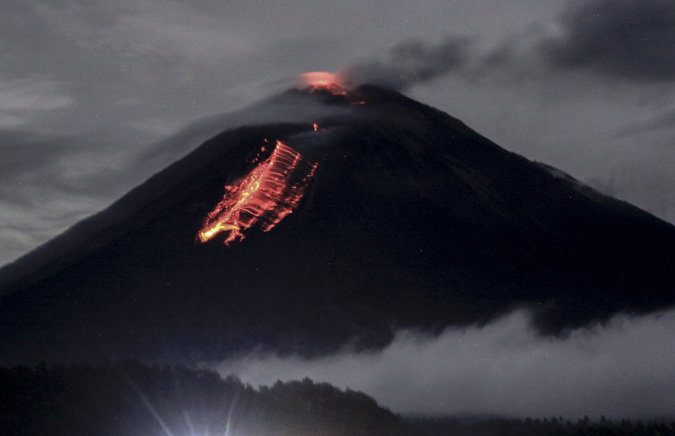
The Peruvian Geophysical Institute (IGP) reports that the eruptive activity of the Sabancaya volcano remains at moderate levels; that is to say with the continuous recording of explosions up to 3.9 km above the summit of the volcano and consequent emissions of ash and gas. Consequently, for the following days, no significant change is expected regarding its activity.
During the above-mentioned period, the IGP recorded the average occurrence of 11 explosions per day. In addition, around 540 volcanic earthquakes have been analyzed, associated with the circulation of fluids (magma, gas, etc.) inside the volcano. Similarly, on April 13, starting at 4:38 p.m., a seismic swarm was recorded consisting of 135 VT-type events associated with the rock rupture. This swarm of earthquakes was located 13 km north of the Sabancaya volcano, 12 km deep; the main earthquake generated a magnitude of M3.7 (see report IGP / CENSIS / RA 2020-0245).
The monitoring of the deformation of the volcanic structure, using GNSS data (processed with fast orbits), does not present any significant anomalies; however, the presence of slight inflation recorded by GPS stations located in the North sector (Hualca Hualca volcano) and Southeast of Sabancaya continues to be observed.
The visual surveillance made it possible to identify columns of gas and ash up to 3.9 km high above the summit of the volcano, which were dispersed towards the North-West, South and South-East sectors of the Sabancaya. Satellite surveillance identified the presence of 8 thermal anomalies with values between 1 MW and 14 MW, associated with the presence of a body of lava on the surface of the crater of the volcano.
Source : IGP.
Photo : Auteur inconnu.
Indonesia , Semeru :
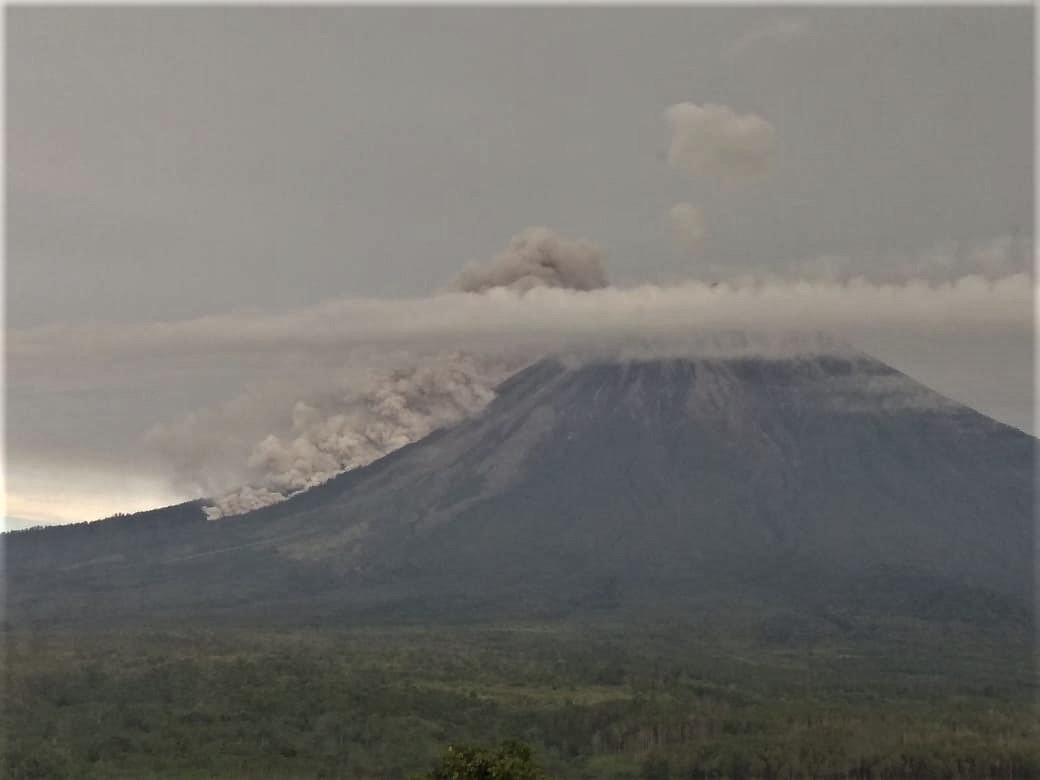
Level of activity at level II (WASPADA). The Semeru volcano (3676 m above sea level) is experiencing a continuous eruption.
The volcano is clearly visible until it is covered with fog. The smoke from the crater is white with a moderate intensity high about 300 m above the top of the crater. The weather is sunny to cloudy, light winds from the northeast and south. Eruptions still occur, resulting in thick, gray-colored eruption columns about 200-300 meters above the summit. Lava flows were observed with a sliding distance of 200 meters from the end of the lava flow.
According to the seismographs of April 20, 2020, it was recorded:
20 eruption / explosion earthquakes
6 avalanche earthquakes
41 emission earthquakes
1 shallow volcanic earthquake
2 deep tectonic earthquakes.
Recommendation:
The community must not carry out activities within a radius of 1 km and in the area up to 4 km in the South-South-East slope sector of the active crater which is an opening area of the active crater of G. Semeru (Jongring Seloko) as a channel for sliding warm clouds.
Be aware of the presence of the lava dome in the Seloko Jongring crater.
VOLCANO OBSERVATORY NOTICE FOR AVIATION – VONA.
Issued: April 21 , 2020
Volcano: Semeru (263300)
Current Aviation Colour Code: ORANGE
Previous Aviation Colour Code: orange
Source: Semeru Volcano Observatory
Notice Number: 2020SMR29
Volcano Location: S 08 deg 06 min 29 sec E 112 deg 55 min 12 sec
Area: East java, Indonesia
Summit Elevation: 11763 FT (3676 M)
Volcanic Activity Summary:
Eruption with volcanic ash cloud at 01h59 UTC (08h59 local)
Volcanic Cloud Height:
Best estimate of ash-cloud top is around 13363 FT (4176 M) above sea level, may be higher than what can be observed clearly. Source of height data: ground observer.
Other Volcanic Cloud Information:
Ash-cloud moving to north.
Remarks:
Eruption recorded on seismogram with maximum amplitudo 22 mm and duration 90 second
Source : PVMBG , Magma Indonésie .
Photos : Umarul Faruq , Pvmbg
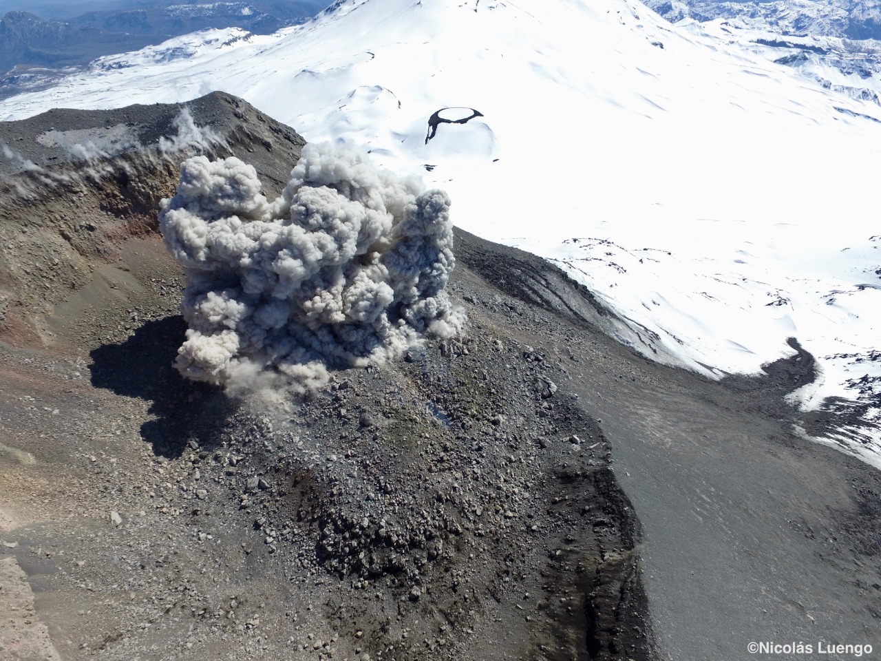
Chile , Nevados of Chillan :
Special volcanic activity report (REAV), region of the Nevados de Chillán volcanic complex, on April 20, 2020 at 8:20 p.m. local time (mainland Chile).
The National Geological and Mining Service of Chile (Sernageomin) discloses the following PRELIMINARY information, obtained thanks to the surveillance equipment of the National Volcanic Surveillance Network (RNVV), processed and analyzed at the South Andes Volcanological Observatory (OVDAS ):
On Monday April 20, 2020 at 8:07 p.m. local time (00:07 UTC), the monitoring stations installed near the Nevados de Chillán volcanic complex recorded an earthquake associated with rock fracturing (Volcano-Tectonic Type VT).
The characteristics of the earthquake are as follows:
TIME OF ORIGIN: 8:07 p.m. local time (12:07 a.m. UTC).
LATITUDE: 36 86 ° S
LONGITUDE: 71.403 ° W
DEPTH: 4.0 km
LOCAL MAGNITUDE: 3.0 ML
OBSERVATIONS:
No surface activity was observed following this event. At the time of publication of this report, the community had not received a notice of perception of this event.
The volcanic technical alert is maintained at the YELLOW level.
Source : Sernageomin .
Photo : Nicolas Luengo