February 29 , 2020 .
El Salvador , San Miguel ( Chaparrastique) :
Special report 4. The activity of the San Miguel volcano tends to decline.
Since Tuesday February 23, the activity of the volcano has remained low. The seismicity record shows an increase in the number of earthquakes (Figure 1), it should be mentioned that these are microseisms of very small magnitude and, therefore, are not perceived by the population.
The origin of these earthquakes is linked to the passage of magmatic fluids in the volcanic system. During the last 24 hours, the seismic amplitude recorded in the VSM station, located in the upper part of the northern flank of the volcano, has shown values between 45 and 75 RSAM units, on average / hour, 150 units being normal (figure 2).
According to the evaluation of volcanic activity, the current scenario could continue for the next few days, without excluding that it could present a process of greater energy, which in turn could generate higher columns and containing more ashes, following the direction of the wind.
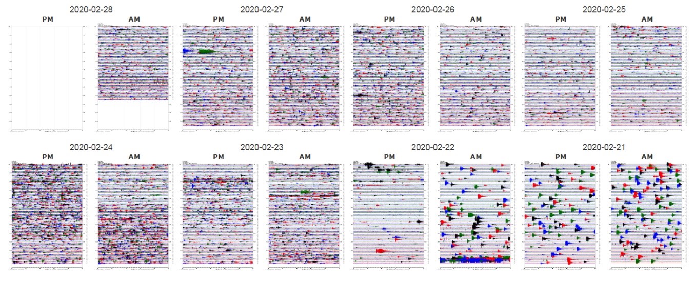
Figure 1. Seismicity record in the VSM station, showing an increase in the number of earthquakes after Saturday, February 22.
Source: MARN
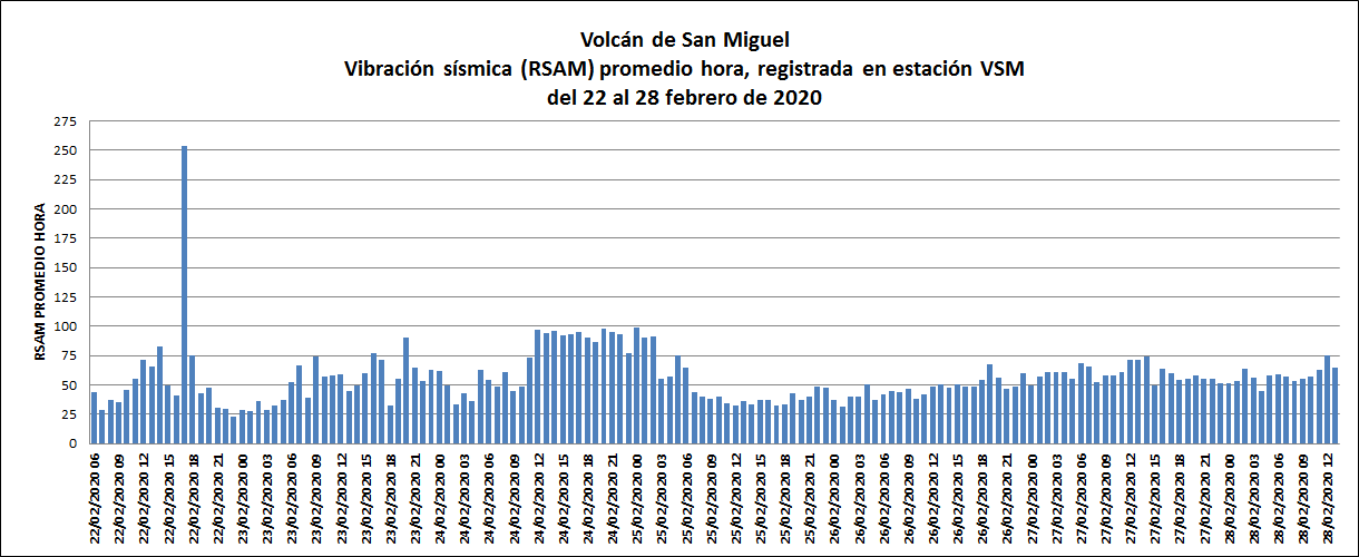
Figure 2. Seismic vibrational behavior of the volcano, in RSAM units, between February 22 and 28.
Source: MARN
The flow of sulfur dioxide emitted by the crater of the volcano shows the presence of magmatic gases, coming from inside the volcanic system, the values remain similar to the previous days (Figure 3). It should be mentioned that the wind direction allows the plume to change direction, so that from February 24 to 26, the value of the flow shows a decrease.
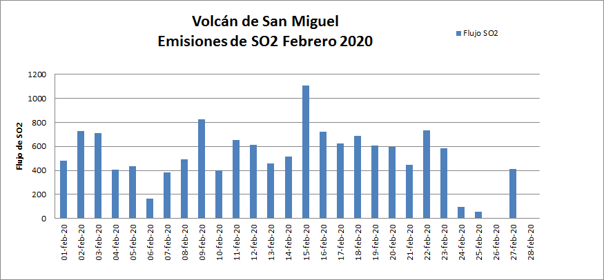
Figure 3. SO2 flow, until February 27. The sulfur dioxide emitted by the crater of the volcano, with slight fluctuations exceeding the threshold.
Source: MARN
The Ministry of the Environment and Natural Resources (MARN) provides 24/7 surveillance of the volcano and close communication with the Directorate General of Civil Protection and local observers. We call on residents, tourists and mountaineers to stay away from the volcano crater due to small explosions with ash fumes that the volcano presents, which can result in the release of gas and ash in a southerly direction -West, carried by prevailing winds. The general population is invited to stay away from the crater of the volcano.
This report will be updated next Friday, March 6. In the event of a significant change in the activity of the volcano, a special prior report will be issued.
Source : Marn .
Photo : Volcanohotspot .
Alaska , Great Sitkin :
52°4’35 » N 176°6’39 » W,
Summit Elevation 5709 ft (1740 m)
Current Volcano Alert Level: ADVISORY
Current Aviation Color Code: YELLOW
Unrest continues at Great Sitkin. The Aviation Color Code and Volcano Alert Level were increased to YELLOW/ADVISORY on Wednesday (26 February 2020) due to an increase in earthquake activity over the previous month. The recent earthquakes are the continuation of intermittent periods of elevated seismicity that have occurred over the past several years. They may be due to an intrusion of magma into the volcano that could result in future eruptive activity, although this is not a certainty. There have been no signs activity in satellite data over the past week, although observations were limited by cloud cover.
Great Sitkin Volcano is monitored with a local real-time seismic network, which will typically allow AVO to detect changes in unrest that may lead to an explosive eruption. Rapid detection of an ash-producing eruption would be accomplished using a combination of seismic, infrasound, lightning, and satellite data.
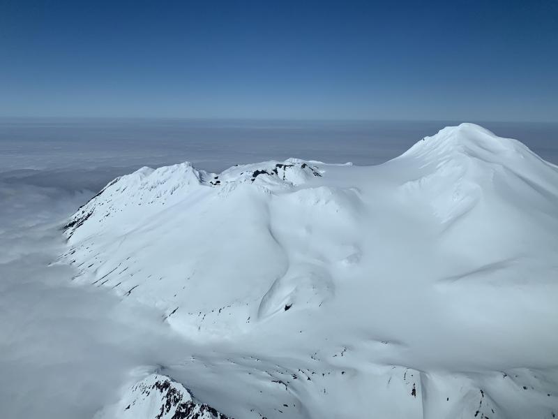
Great Sitkin volcano, looking north, as seen from Alaska Airlines Flight 161 from Adak to Anchorage. Photo by Pilot Dave Clum.
Great Sitkin Volcano is a basaltic andesite volcano that occupies most of the northern half of Great Sitkin Island, a member of the Andreanof Islands group in the central Aleutian Islands. It is located 43 km (26 miles) east of the community of Adak. The volcano is a composite structure consisting of an older decapitated volcano and a younger parasitic cone with a 2-3 km diameter summit crater. A steep-sided lava dome, emplaced during an eruption in 1974, occupies the center of the crater. Great Sitkin erupted at least three times in the 20th century, most recently in 1974. That eruption produced a lava dome and at least one ash cloud that likely exceeded an altitude of 25,000 ft above sea level. A poorly documented eruption occurred in 1945, also producing a lava dome that was partially destroyed in the 1974 eruption. Within the past 280 years a large explosive eruption produced pyroclastic flows that partially filled the Glacier Creek valley on the southwest flank.
Source : AVO.
Photos : Mayo, Wyatt ( 2019 ) , Clum, Dave (2019)
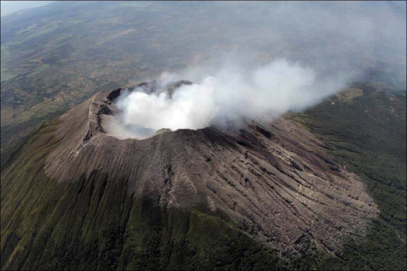
Indonesia , Karangetang :
Level of activity at level III (SIAGA). G. Karangetang (1,784 m above sea level) entered an eruption period since November 25, 2018. The last eruption occurred on November 29, 2019, resulting in an eruption column height of 100 meters. The color of the column was observed to be white.
The volcano is clearly visible until it is covered with fog. The smoke from the crater was white with moderate intensity, about 50 meters high above the summit. The weather is sunny / rainy, the wind blows weak to moderate towards the West, the South and the South-West. Air temperature around 25-32 ° C.
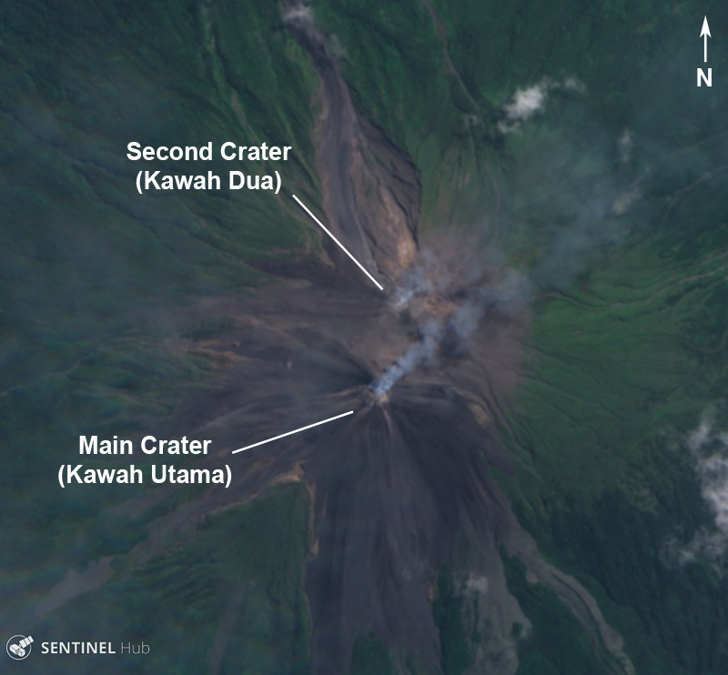
A Sentinel-2 image of Karangetang showing two active craters producing gas and vapor emissions with a small amount of ash on August 7, 2019. Source: Sentinel Hub Playground.
According to the seismographs of February 28, 2020, it was recorded:
11 explosion earthquakes.
2 shallow volcanic earthquakes
2 earthquakes felt
8 tectonic earthquakes.

Recommendation:
The community and visitors / tourists should not approach, climb or move around in the danger forecast area, which is a radius of 2.5 km around the summit of Kawah Dua (North crater ) and the main crater (South crater) and the sectoral expansion zone of Kawah Dua towards the North – North-West up to 4 km, as well as the main crater up to 3 km to the West.
It is recommended that communities around Mount Karangetang prepare masks to cover their noses and mouths, in order to anticipate the potential danger of respiratory problems in the event of ash rain.
Communities living around the banks of rivers that originate from the summit of Mount Karangetang must increase their preparedness for the potential threat of lahars and flash floods that can descend to the coast.
Source : PVMBG.
Photos : Sentinel Hub Playground via GVP , Oystein Lund Andersen via GVP.
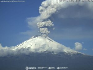
Guatemala , Santiaguito :
Activity type: Pelean
Morphology: Complex of dacitic domes
Location: 14 ° 44 ’33 ˝ Latitude N; 91 ° 34’13˝ Longitude W
Height: 2500msnm
Atmospheric conditions: Clear
Wind: Southeast
Precipitation: 5.3 mm.

Activity:
White degassing pulses that rise to a height of 2900 meters above sea level (9514 feet) disperse in a southwest and northwest direction. Small explosions are recorded which raise the columns of ash at heights of 3,400 meters above sea level (11,154 feet) which disperse to the southwest and northwest. Weak to moderate avalanches are generated towards the South and South-West flanks with descending paths towards the base of the dome.
Source : Insivumeh .
Photo : annie winson , earthobservatory.sg