December 07 , 2019.
Alaska , Shishaldin :
54°45’19 » N 163°58’16 » W,
Summit Elevation 9373 ft (2857 m)
Current Volcano Alert Level: WATCH
Current Aviation Color Code: ORANGE
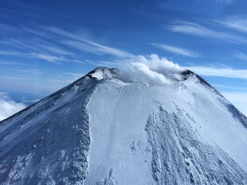
The low-level eruption of Shishaldin volcano that began in late July continues. This past week was marked by episodic effusion of lava flows and low-level Strombolian explosive activity.
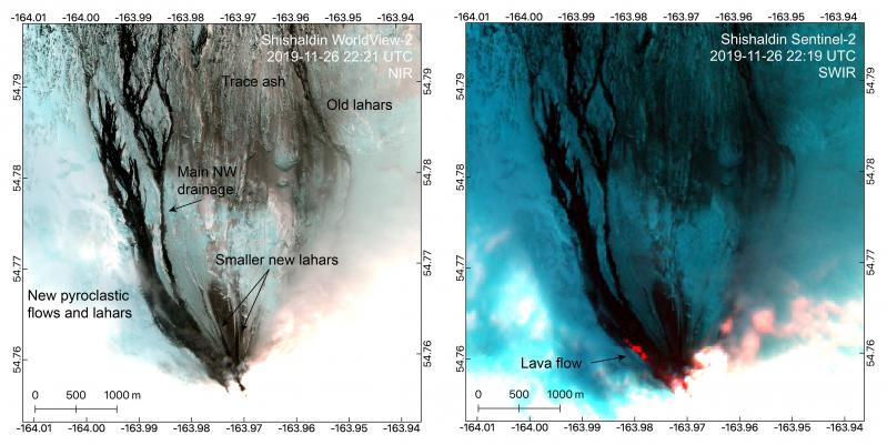
Sentinel-2 and WorldView-2 captured good views of recent ash and pyroclastic density current deposits, as well as lahars and a lava flow, on these November 26 images of Shishaldin Volcano. The summit is largely obscured by vigorous steaming but a near-infrared (NIR) anomaly shows the vent at the top of the active scoria cone. The lava flow is apparent in the short-wave infrared (SWIR) bands in the Sentinel-2 image with a run out of ~1 km. New lahars on the northwest flank can be traced into drainages that extend all the way to the coast. Others reach ~4.7 km to the NW and ~1 km to the N. Trace ash deposits extend at least 7 km to the north, while a thicker northward directed deposit extends ~1.5 km from the vent. The package of flows to the NW include lahars in meltwater channels as well as pyroclastic density current deposits. The furthest of these pyroclastic density currents went about 3.4 km from vent.
Thus far, the 2019 eruption has produced lava flows, pyroclastic flows, and lahars (mudflows) on the flanks of the volcano. Ash emissions have been very minor and restricted to the immediate vicinity of the volcano and altitudes of less than 12,000 ft. asl. During this heightened level of activity, however, more powerful explosions could occur with little warning and produce higher ash clouds that may pose a hazard to aircraft.
From Saturday, November 31 to Monday, December 2 seismicity was elevated and high surface temperatures were detected in satellite data each day. A high-resolution satellite image confirmed the emplacement of a 1.5 km lava flow on the NW flank on December 1. By December 3 seismicity and surface temperatures in satellite decreased.
On Wednesday, December 4, seismicity and surface temperatures once again increased, and a pilot report that day confirmed renewed lava flows down the volcano’s flank. Minor steam or ash emissions were observed in clear web camera views early Thursday, December 5 from the summit and north flank. Also on Thursday, very strongly elevated surface temperatures were detected in satellite imagery, and seismicity, including detection of Strombolian explosions, continued to increase until around 21:00 AKST on December 5 when the continuous tremor ended and was replaced by episodic tremor bursts and occasional detections of Strombolian vent activity.
Shishaldin is monitored by local seismic and infrasound sensors, satellite data, web cameras, a telemetered geodetic and tilt network, and distant infrasound and lightning networks.
Source : AVO.
Photos : Dietterich, Hannah , Mulliken, Katherine .
Italy / Sicily , Etna :
VOLCANIC ACTIVITY COMMUNIQUE FOR ETNA, 6 December 2019, 18:34:49 h UTC (19:34 h local time).
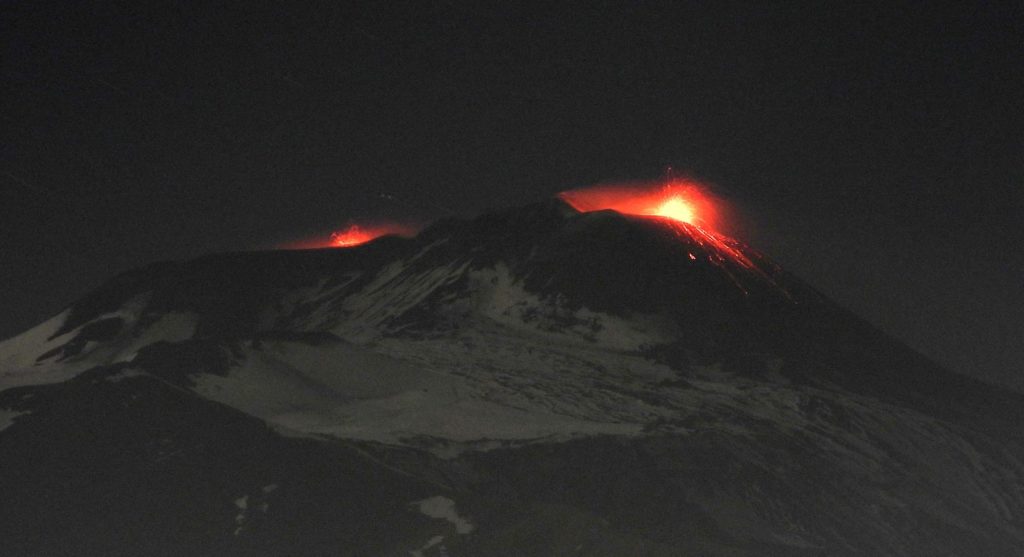
The Istituto Nazionale di Geofisica e Vulcanologia, Osservatorio Etneo, reports that from about 18:00 h UTC onward, the videosurveillance cameras show a gradual intensification of the Strombolian activity at the New Southeast Crater, which had already been under way at about 16:00 UTC, producing small and discontinuous explosions.
At the time of release of this communiqué, ejected pyroclastics fall onto the slopes of the cone.
At the same time, intracrater Strombolian activity is continuing at the Voragine and Bocca Nuova craters, as described in the latest weekly Bullegin of 3 December 2019.
No significant variations are observed thus far in the volcanic tremor amplitude.
The photo above was taken on the evening from Tremestieri and show the strombolian activity at New Southeast Crater (at right), and small Strombolian explosions at the Voragine crater (at left).
Source : INGV.
Photo : INGV.
Japan , Nishinoshima :
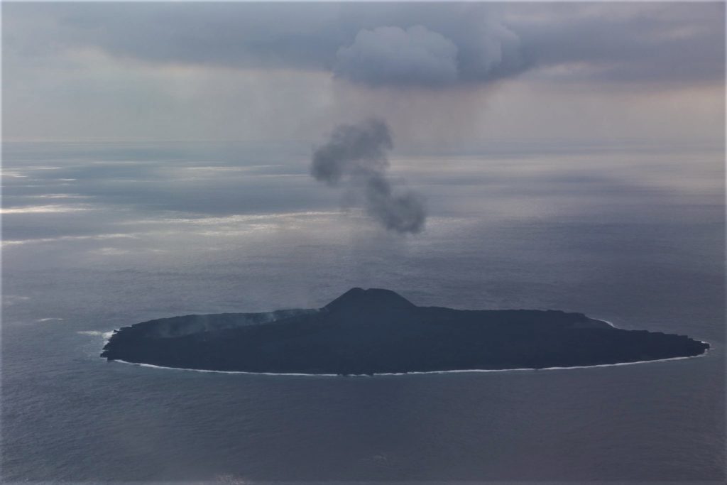
The Japanese coast guards were sent photos indicating the resumption of activity of Nishinoshima. The photo below shows that an eruptive vent formed at the base of the main cone that had been formed during the eruption phase of 2013/2015. A lava flow is emitted towards the coast.
A small lava projection activity is underway from the vent.
The small island of Nishinoshima was enlarged when several new islands coalesced during an eruption in 1973-74. Another eruption that began offshore in 2013 completely covered the previous exposed surface and enlarged the island again. Water discoloration has been observed on several occasions since. The island is the summit of a massive submarine volcano that has prominent satellitic peaks to the S, W, and NE. The summit of the southern cone rises to within 214 m of the sea surface .
Sources et photo : Gardes cotes Japonais via Sherine France. GVP .
Indonesia , Karangetang :
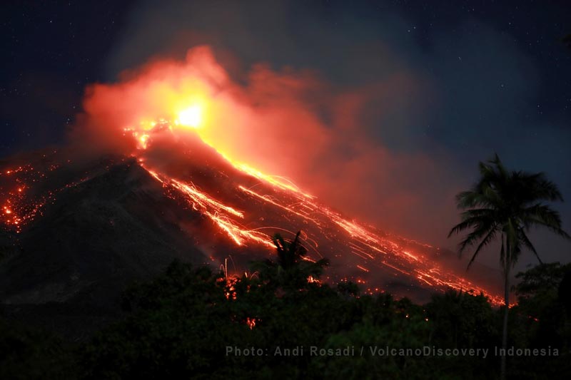
Activity Level at Level III (SIAGA). Karangetang (1,784 m) has been erupting since November 25, 2018. The last eruption occurred on November 29, 2019, resulting in an eruption column height of 100 m. The color of the column was observed gray in color.
The volcano is clearly visible until it is covered with fog. The smoke from the main crater is observed with a low intensity, a white color, moderately high about 100-150 meters above the summit. Sunny to cloudy weather, weak winds from South-East and South. The temperature is about 26 to 31 ° C.
The incandescence of the crater rises up to 50 meters. The lava descends from the top of the main crater towards Kali Batang and West Beha for about 800 to 1000 m, up to Kali Sense, Nanitu, Sesepe and Pangi, about 1000 to 1500 m. The incandescence of crater 2 rises up to 10 m. The smoke from crater 2 is white, fine to medium, rising to 50 to 100 m. The rumblings seem weak.
Selon les sismographes du 5 décembre 2019 , il a été enregistré:
87 tremblements de terre d’avalanches
13 tremblements de terre d’explosion .
2 tremblements de terre Hybride / Phase multiple
10 tremblements de terre volcaniques peu profonds
1 tremblement de terre volcanique
1 tremblement de terre ressenti (échelle I MMI)
5 tremblements de terre tectoniques
2 tremblements de terre harmoniques
Tremort continu, amplitude 0,5-7 mm (valeur dominante 5 mm).
Recommandation:
(1) La communauté et les visiteurs / touristes ne doivent pas s’approcher, ne pas grimper et ne pas se déplacer dans la zone de prévision de danger qui a un rayon de 2,5 km autour du sommet du cratère Dua (cratère Nord) et du cratère principal (Sud) et la zone d’expansion sectorielle du Kawah Dua vers Nord-Nord-Ouest sur 4 km , ainsi que du cratère principal jusqu’à 3 km vers l’Ouest.
(2) Il est recommandé aux communautés autour du G. Karangetang de préparer des masques pour le nez et la bouche, afin d’anticiper le danger potentiel de problèmes respiratoires en cas de pluie de cendres.
(3) Les communautés vivant autour des rives des rivières qui proviennent du sommet du mont Karangetang doivent accroître leur préparation face à la menace potentielle de lahars et d’inondations soudaines qui peuvent se déverser jusqu’à la côte.
VONA:
Le dernier VONA a reçu un code couleur JAUNE, publié le 25 novembre 2018 à 13:32 WITA, lié à l’émission de cendres volcaniques d’une hauteur d’environ 2284 m au-dessus du niveau de la mer ou à environ 500 m au-dessus du sommet, le vent soufflait vers l’Est.
Source : PVMBG.
Vidéo : S Chermette / 8 Jours voyages .
Photo : Andi Rosadi / VolcanoDiscovery Indonesia

Stromboli is not in Sicily .it is separated by a sea from the island of Sicily.
as is Mt Etna which is separated from the Mainland of Italy, by the Straits of Messina,
this however is on Sicily on the eastern side.North of Catania .
là , on parle de l’Etna , qui est bien en Sicile