July 26 , 2019.
Indonesia , Tangkuban Parahu :
The seismic activity of Mount Tangkuban Parahu increases, it is forbidden for visitors to approach the crater.
The volcanic activity of Mount Tangkuban Parahu in Subang, West Java, has further increased. The observation post of the Tangkuban Parahu Volcano (PVMBG) noted from the seismographic recordings of 21 July 2019 that 425 earthquake swarms had occurred.
According to Ilham Mardikayanta, officer of the observation post of the Tangkuban Parahu volcano, the increase in activity of Mount Tangkuban Parahu was clearly visible.

« From mild to moderate pressure, the smoke from the crater is white, of moderate to thick intensity and rises 0 m above the top of the crater, » Ilham said in a written press release received on Monday. July 2019).
The solfatare emitting this smoke is located 20-130 meters from the solfatara hole at the bottom of the crater. Ilham also mentioned that the harmonic tremors were 2 times higher, with an amplitude of 1.5 to 2 mm and a duration of 44 to 45 seconds.
During this time, the number of low frequency earthquakes is up to 3 times higher, with an amplitude of 2 to 4 mm and a duration of 14 to 33 seconds.
At the same time, PVMBG leader Kasbani said the state of my Tangkuban Parahu was still normal.
« Only seismic swarms are increasing, the state of alert is still at level 1 (normal), » Kasbani said.
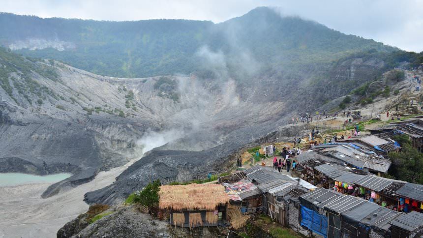
The PVMBG, he said, recommends to people living around Mount Tangkuban Parahu, that traders, tourists and mountaineers are not allowed to descend near the base of Ratu and Upas Craters. In addition, it is forbidden to stay in the area of active craters of the Tangkuban Parahu Volcanic Complex.
« The surrounding community, traders, tourists, mountaineers and tourism officials need to be aware of the increasing concentration of volcanic gases and are encouraged not to linger on the lips of the active crater to avoid exposure to gases that could harm health and safety, « Kasbani said. .
He also asked the surrounding community to stay calm, to carry out their activities as usual. And always pay attention to the development of Mount Tangkuban Parahu activities published by the local BPBD.
Source : liputan6.com.
Photo : langyaw.com , dolandolen.com.
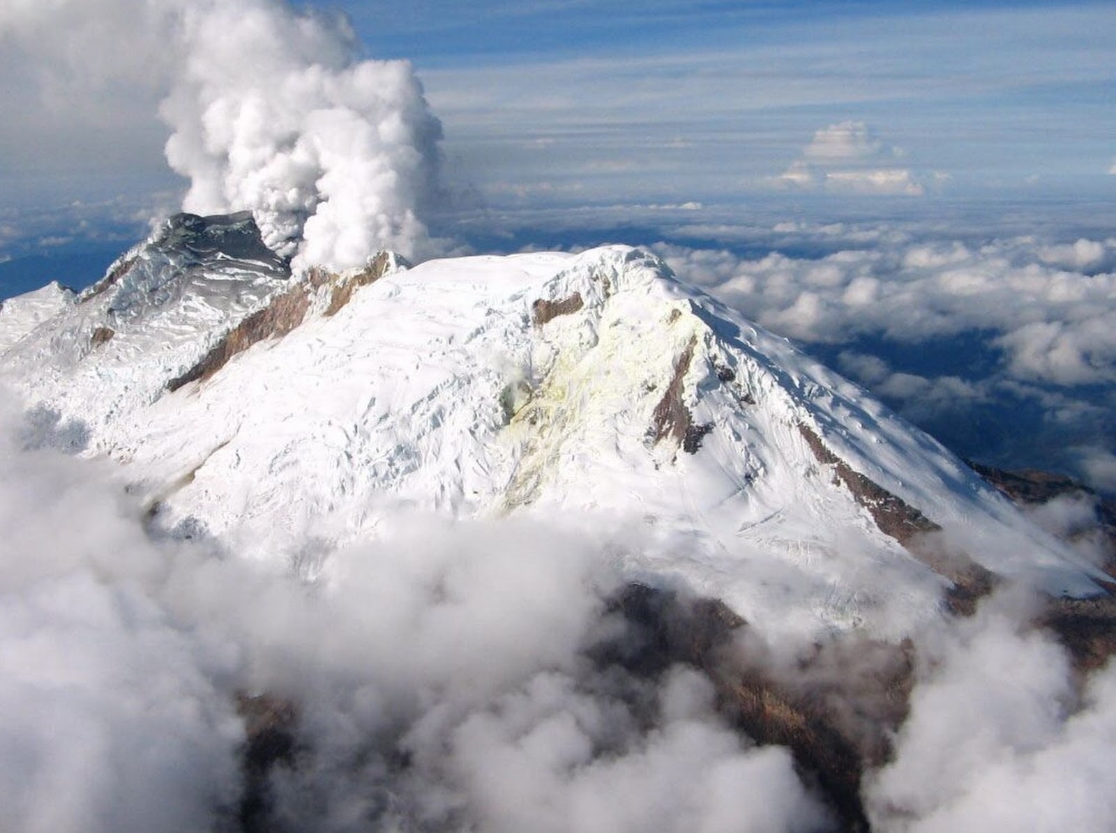
Hawaii , Mauna Loa :
19°28’30 » N 155°36’29 » W,
Summit Elevation 13681 ft (4170 m)
Current Volcano Alert Level: ADVISORY
Current Aviation Color Code: YELLOW
Activity Summary:
Mauna Loa Volcano is not erupting. Over the past week, rates of deformation and seismicity continue to remain slightly elevated.
Observations:
During the past week, approximately 75 small-magnitude earthquakes (most less than M2.0) occurred beneath the summit and upper Southwest Rift Zone. Most earthquakes occurred at shallow depths of less than 5 km (3 miles).

The black unit in the foreground is the 1903 fissure vents and flows from the Southwest Rift Zone of Mauna Loa. Moving clockwise around the photo, the adjacent set of hills are the 1926 spatter ramparts. Above the 1926 ramparts, the dark colored hills (red interior) are vents for the 1919 ‘Ālika flow. In the middle of the image, the dark flows and those far afield are all from the 1950 eruption of Mauna Loa. The mountain barely visible in the far background is Hualālai.
Global Positioning System (GPS) and Interferometric Synthetic Aperture Radar (InSAR) measurements show continued summit inflation, suggestive of recharge of the volcano’s shallow magma storage system.
No significant changes in volcanic gas release at Sulphur Cone on the Southwest Rift Zone were measured. Fumarole temperatures at both Sulphur Cone and at the summit remain unchanged.
Source : HVO.
Kamchatka , Karymsky :
54.05 N, 159.44 E;
Elevation 4874 ft (1486 m)
Aviation Colour Code is ORANGE
A moderate activity of the volcano continues. Ash explosions up to 19,700 ft (6 km) a.s.l. could occur at any time. Ongoing activity could affect low-flying aircraft.
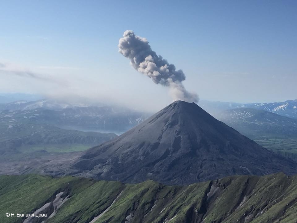
A moderate activity of the volcano continues. Satellite data showed a thermal anomaly over the volcano on July 18-19, and 25; ash cloud drifted about 134 km to the south-east from the volcano on July 25.
Source : Kvert.
Photo : N. Balakhontseva.
Nicaragua , Masaya :
New explosion on the Masaya volcano after opening a vent.
The Institute of Territorial Studies of Nicaragua (Ineter), reported a new explosion recorded in the crater Santiago of the Masaya volcano, on 24/07/2019 at 16h55.
Rosario Murillo, vice-president of Nicaragua, released Ineter’s report on the second Masaya volcano explosion, which said the event originated from « an opening of the Santiago crater floor that released gas and ashes after being temporarily obstructed. »
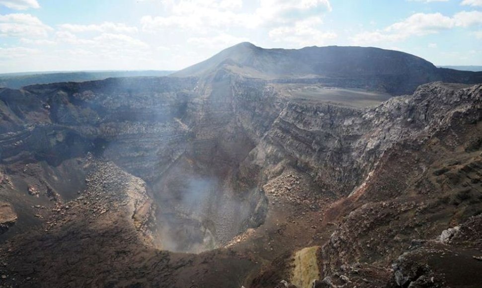
Due to this phenomenon, Masaya Volcano National Park remains closed. Ineter continuously monitors the volcano.
After the first explosion on the Masaya volcano, caused by the obstruction of an internal conduit in the crater Santiago, Ineter asked the population to take precautionary measures because a new explosion could be generated, a situation already occurred Tuesday.
According to Ineter, this is a phenomenon that occurs every three years and does not represent an alarm signal.
According to the Nicaraguan Institute of Territorial Studies (Ineter), this was the second explosion of the past four days.
Last Sunday, the Masaya volcano, located 23 kilometers southeast of Managua, experienced an explosion that forced the authorities to put it « under special surveillance ».
A similar activity occurred on the Masaya volcano between December 2015 and March 2016, when the lava lake formed in its main crater.
The Masaya is one of seven active volcanoes in Nicaragua and since 1520 it has recorded at least 18 different activity periods, including the volcanic eruptions of 1772 and 1820, according to Ineter.
Source : diariometro.com , eldiario.es
Photo : El Nuevo Diario ( archives) .
Colombia , Nevado del Huila :
Weekly activity bulletin of the Nevado del Huila volcano
The level of activity of the volcano continues at the level: Activity level Yellow or (III): changes in the behavior of volcanic activity.
According to the analysis and evaluation of the information obtained through the monitoring network of the Nevado del Huila volcano, from 16 to 22 July 2019, the COLOMBIAN GEOLOGICAL SERVICE – Volayological and Volcanic Observatory of Popayán informs that:
• During the reporting period, 77 seismic events were recorded, of which 40 were related to rock fracturing processes (type VT) and 37 to fluid dynamics in volcanic vents, all classified as long-period events. (LP type). ).
• During the week, 15 TV-type events were located, all of low magnitude, mostly located northeast of the volcanic building. The maximum magnitude recorded is an earthquake of magnitude M 2.0, located 11.5 km northeast of the central peak at a depth of 7.5 km.
• On July 16, a mobile measurement of SO2 emissions from the Nevado del Huila volcano was conducted between the cities of Tunía (Cauca) and Villarrica (Cauca). The column of gas was detected between the Caldono and Santander populations of Quilichao and the calculated flow was 1248 t / day, which is considered low.
• The images obtained during the week by the webcams of Caloto, Tafxnú, Maravillas and La Palma showed a weak degassing of the volcanic system.
• Monitoring sensors for soil deformation, magnetic fields and infrasonic waves have not recorded any changes due to changes in volcanic activity.
It is recalled that, although the VT-type seismicity located to the northeast of the Nevado del Huila volcano is in its zone of influence, these events are generated in an area with tectonic activity and so far have not affected other volcanic monitoring parameters, therefore, the level of activity of the volcano has not changed, which continues to Amarillo or level III.
Source : SGC.
Photo : Parque-Nacional-