July 12 , 2019.
Italy, Stromboli :
STROMBOLI VOLCANO 19:00 (LOCAL TIME) NOTICE OF ACTIVITY OF 09/07/2019
Tuesday, July 09, 2019
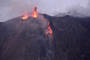
Analysis of satellite data and comparison with direct observations indicate that the July 3, 2019 eruption resulted in the lowering and subsequent expansion of the outer edge of the southwestern sector of the crater terrace.
The processing of satellite data (Sentinel-2), superimposed on the images of Google Earth, shows an increase in the area affected by thermal anomalies following the paroxysm which indicates a widening of the crater terrace of about 120 meters in the West direction (Figure 1).
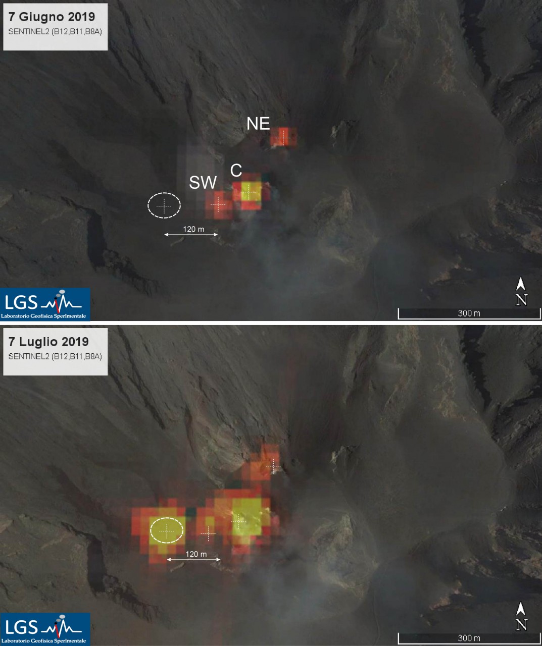
Figure 1. Heat treatment of satellite data (Sentinel-2) superimposed on Google Earth images. 07/06/2019 – Localized thermal activity in craters before paroxysm; 07/06/2019 – Thermal activity detected as a result of the paroxysmal explosion and the widening of the crater terrace.
Figure 2 shows the location of the thermal anomalies assessed by the Sentinel-2 satellite images between 2015 and 2019 along the East-West component. The image clearly shows how, after the paroxysm, there are thermal anomalies in an area where they had never been recorded in the last 4 years. Figure 2b shows a map with the cumulative location of thermal anomalies recorded over the entire period (2015-2019).
The boxes indicate the position of the main vents. The anomaly of July 7 is much more misplaced than the position of the previous anomalies.
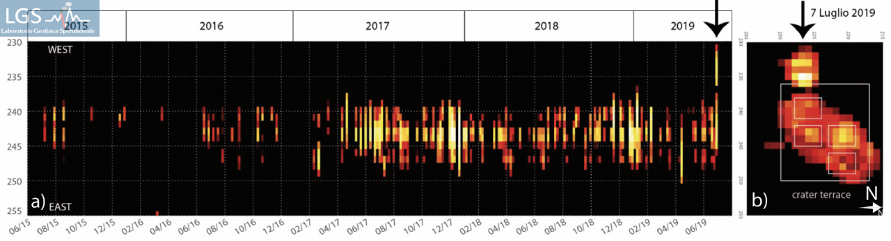
Figure 2. Migration of thermal anomalies following the paroxysmal event evaluated by satellite images. a) time series of the extent of anomalies in the east-west direction. b) cumulative extension of the surface of the anomalies.
The comparison between the Sentinel2 satellite images (Figure 3) and the field survey conducted on 07/07/2019 (Figure 3) shows how this anomaly is located on the new southwestern Crater rim.
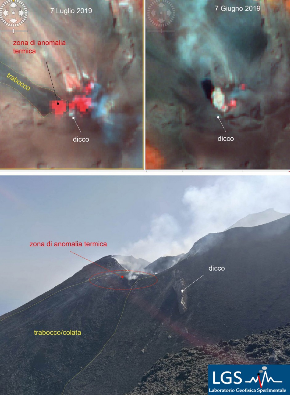
Figure 3. Comparison between Sentinel 2 satellite images and ground surveys. The photo was taken on July 7, 2019 from Portella di Ginostra
This widening of the crater terrace towards the western sector is also confirmed by the visual observations made from Portella di Ginostra before and after the paroxysmal event of July 3 (Figure 4). The images clearly show how the edge of the current crater (red line) has migrated to the west from about 120 to 140 meters.
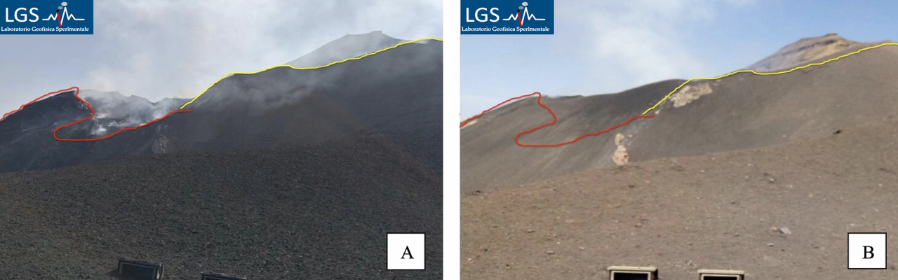
Figure 4. Comparison of images before and after the event of July 3, 2019. July 7, 2019 (A); June 7, 2019 (B).
Even though the phenomena of falling rocks have increased in recent days, there are no conditions of instability on this side of the Sciara del Fuoco.
STROMBOLI VOLCANO 19:00 (LOCAL TIME) NOTICE OF ACTIVITY OF 10/07/2019
Wednesday, July 10, 2019
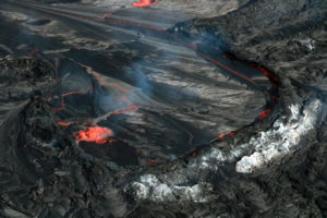
The inspection carried out today in Punta dei Corvi at 15:30 with the help of the thermal camera made it possible to announce that several overflows at the top are active.
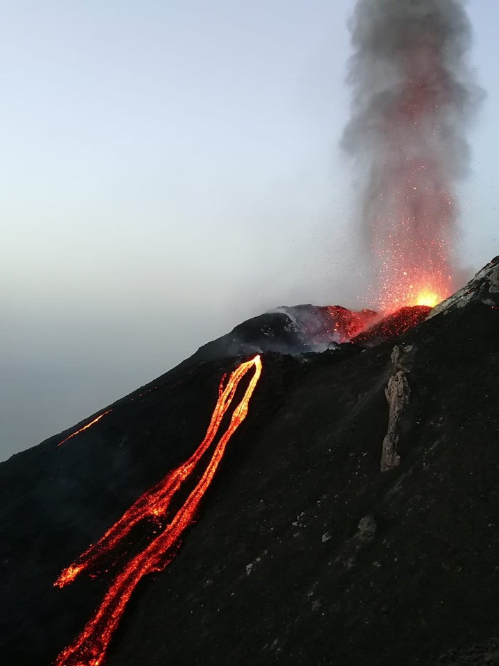
From these two main streams start along the center and the southern flank of the Sciara del Fuoco. The southern front rises at about 600 m altitude, while the front of the central part of the Sciara reaches about 400 m above sea level.
Both flows contribute to the rolling of hot materials that accumulate at the base of the slope forming small deltas.
TSUNAMI RECORDED AT STROMBOLI AFTER THE PAROXYSTIC EVENT OF 07/03/2019
Monday, July 08, 2019
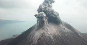
The paroxysmal explosion of July 3, 2019 generated two pyroclastic flows that spread to the sea surface about one kilometer from the shoreline of Sciara del Fuoco (Figure 1).
These flows produced a small wave of tsunami that was recorded by the two Mede Elastici (wave buoys), placed on both sides of the Sciara del Fuoco, about 350 meters from the coast, which were affected by pyroclastic materials (Figure 2).
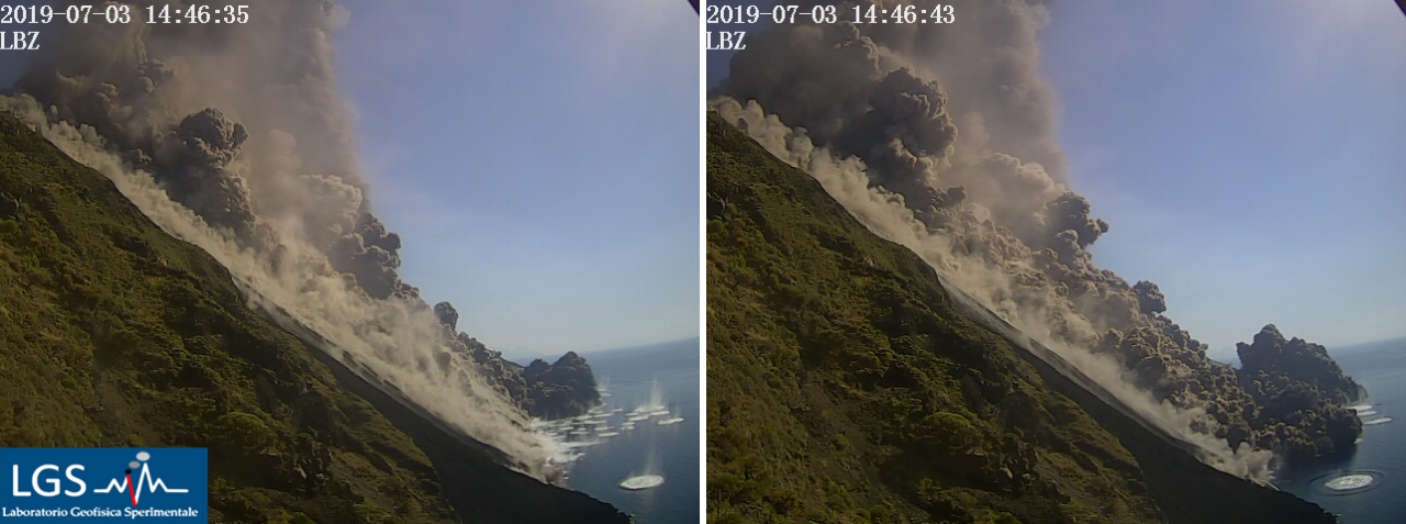
Figure 1. Visible camera images showing the two pyroclastic flows
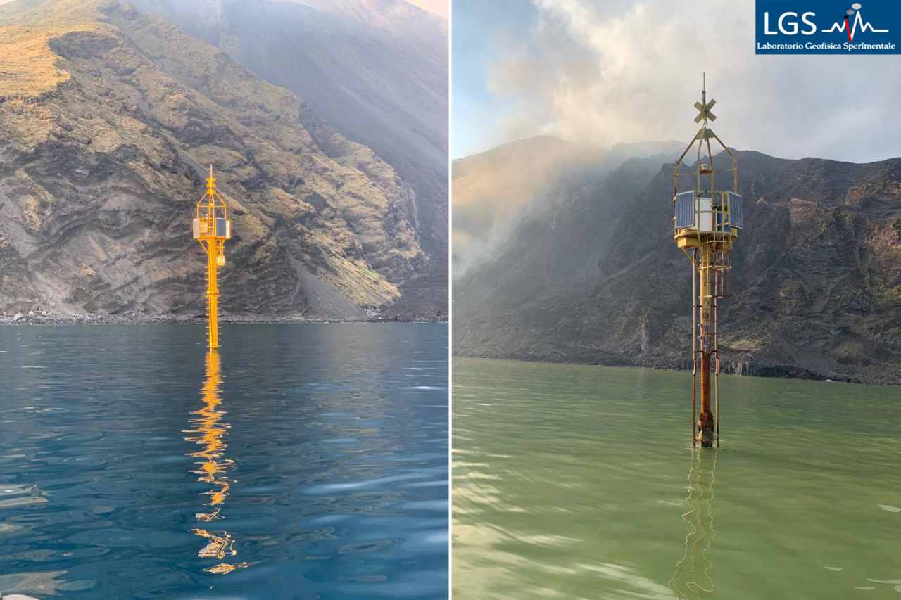
Figure 2: Photos of the two buoys installed in Stromboli. As also shown in Figure 1, PLB and the color of the sea were affected by the pyroclastic flow (provided by the Coast Guard).
The entry into the sea of both flows caused an initial rise in sea level of about 1 meter. The tsunami wave recorded by the buoy closest to the stream (Punta dei Corvi) had a total amplitude of about 2 meters and a duration of 30 seconds (Figure 3). The wave was immediately attenuated and about 2 km from the source (Punta Labronzo), it was only 40 cm high.
This is the first time a tsunami is recorded, generated by a sub-aerial pyroclastic flow at the source of the event.
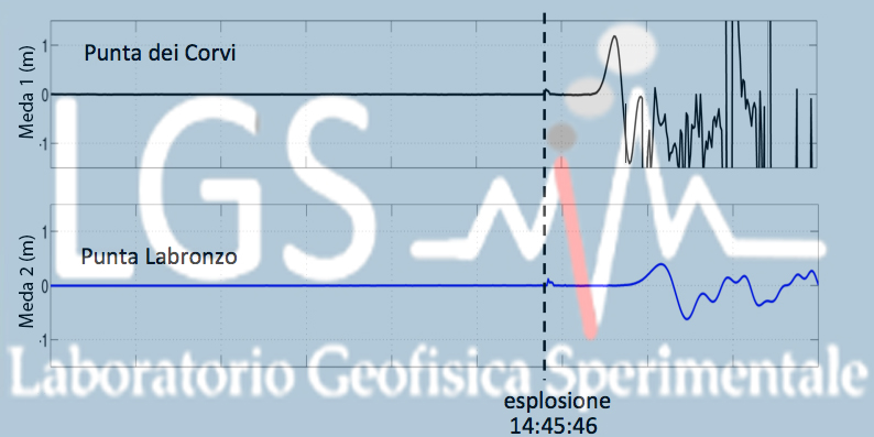
Figure 3: Tsunamis recorded at PDC and PLB stations
Sources : LGS – Laboratorio Geofisica Sperimentale . http://lgs.geo.unifi.it/index.php/blog/comunicato-stromboli-10-luglio-h2130?fbclid=IwAR3KXR6Dhvrck4-Mf-ofMA9wOAMT1QY-0gexUm4ictIGsDIZmPIGfPzN42g
http://lgs.geo.unifi.it/index.php/blog/comunicato-stromboli-9-luglio-h1900
http://lgs.geo.unifi.it/index.php/blog/tsunami-registrato-stromboli-3-luglio-2019
Photo : Adriano Di Pietro (geologo) – guida vulcanologica a Stromboli
Hawaii , Mauna Loa :
19°28’30 » N 155°36’29 » W,
Summit Elevation 13681 ft (4170 m)
Current Volcano Alert Level: ADVISORY
Current Aviation Color Code: YELLOW
Activity Summary:
Mauna Loa Volcano is not erupting. Slightly elevated rates of deformation and seismicity have not changed significantly in the past week.
Observations:
During the past week, approximately 95 small-magnitude earthquakes (less than M2.0) occurred beneath the summit and flanks of the volcano, compared to ~115 earthquakes the week before. Most earthquakes occurred at depths of less than 5 km (3 miles). Additional deeper seismicity at depths less than 10 km (6 miles) was primarily scattered beneath the southwest flank of the volcano.
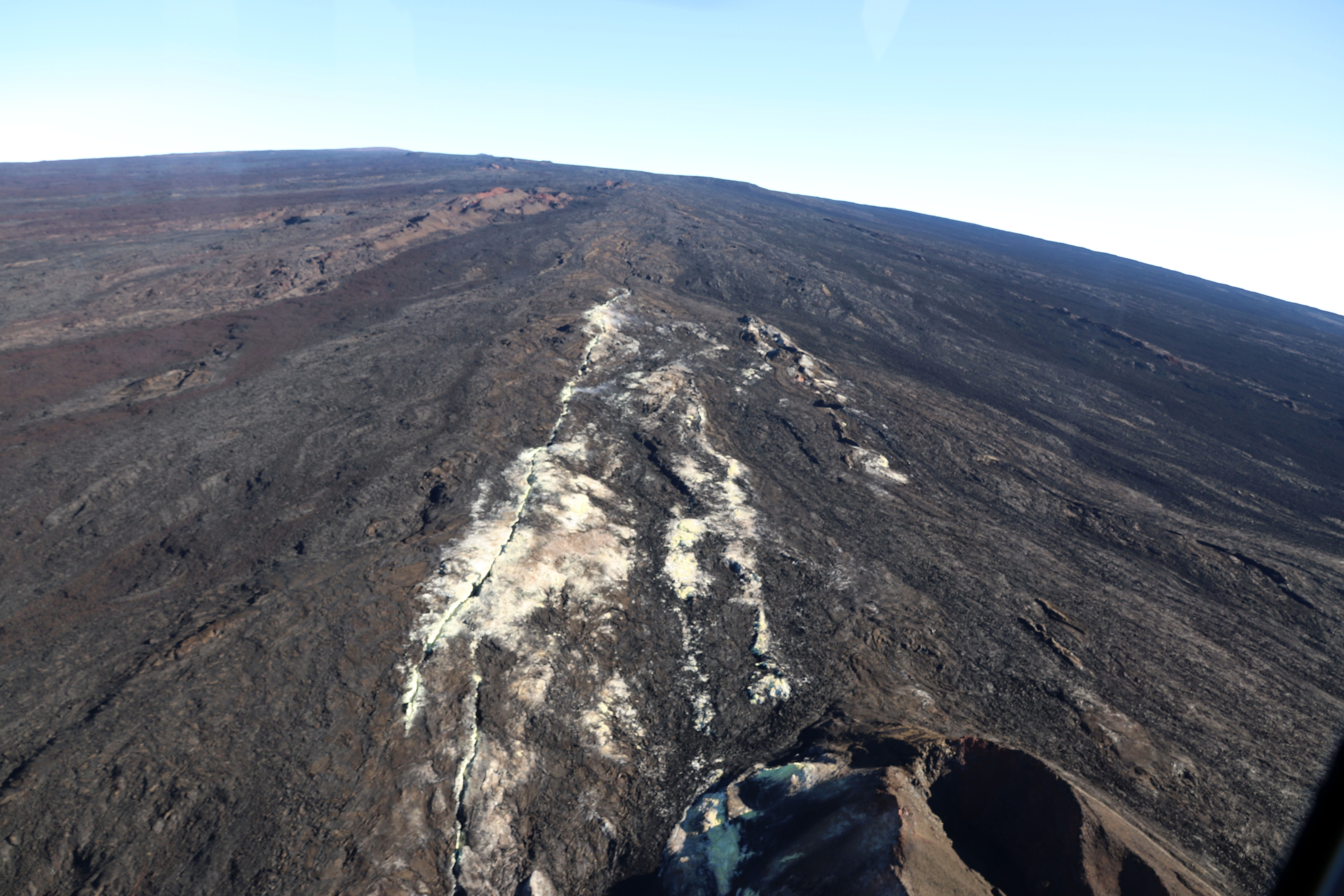
This aerial view looking upslope on Mauna Loa shows the expanse of the volcano’s upper Southwest Rift Zone. The white and yellow altered ground surface is part of the Sulphur Cone area.
Seismicity remains elevated, with an average of at least 50 shallow small-magnitude earthquakes per week following an earthquake swarm in October 2018. This compares to a rate of fewer than 20 earthquakes per week beneath the volcano in the first half of 2018.
Global Positioning System (GPS) and Interferometric Synthetic Aperture Radar (InSAR) measurements show continued summit inflation, suggestive of renewed recharge of the volcano’s shallow magma storage system. This rate of inflation has not changed since the alert level was raised on July 2nd, 2019, and remains consistent with increased rates of inflation following the October 2018 earthquake swarm.
No significant changes in volcanic gas release at Sulphur Cone on the Southwest Rift Zone were measured. Fumarole temperatures at both Sulphur Cone and at the summit remain unchanged
Source : HVO.
Colombia , Chiles / Cerro Negro :
Weekly activity bulletin of Chiles and Cerro Negro volcanoes.
The activity level of volcanoes continues at the level: YELLOW LEVEL ■ (III): CHANGES IN THE BEHAVIOR OF THE VOLCANIC ACTIVITY.
Following the activity of the CHILE and CERRO NEGRO volcanoes , the COLOMBIAN GEOLOGICAL SERVICE (SGC) reports that:
During the period from July 2 to July 8, 2019, the seismic activity did not show any significant variations in the number and energy released compared to the previous period. The predominant type of seismicity was always that associated with rock fracture within the volcanic system, being mainly located in an area to the south and southwest, at epicentral distances less than 5 km from the summit of Chiles volcano, depths of up to 9 km and a maximum local magnitude of 2 on the Richter scale.
No recorded earthquakes were felt by residents of the Chiles – Cerro Negro volcanic complex.
Other geophysical and geochemical parameters of volcanic monitoring did not show significant variations.
The Colombian Geological Service and the Institute of Geology of the National Polytechnic School of Ecuador are attentive to the evolution of the volcanic phenomenon and will continue to report the changes observed as soon as possible.
Source : SGC
Photo : SGC
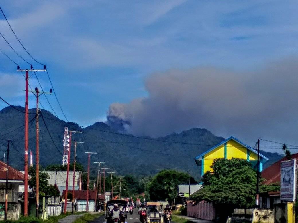
Indonesia , Dukono :
Level of activity at Level II (WASPADA). The Dukono volcano (1229 m above sea level) has continuous eruptions.
Since yesterday and until this morning, the volcanic peak was clear until it was covered with fog. The smoke from the main crater is white / gray, thick, 200 to 400 meters above the summit. The wind was weak in the east.
The seismographs, July 11, 2019 recorded:
1 distant tectonic earthquake
Tremor continuous amplitude 0.5 – 10 mm, dominant value: 2 m
Recommendation:
People around G. Dukono and visitors / tourists do not climb or approach the crater of Malupang Warirang within 2 km.
VOLCANO OBSERVATORY NOTICE FOR AVIATION – VONA .
Issued: July 12 , 2019
Volcano: Dukono (268010)
Current Aviation Colour Code: ORANGE
Previous Aviation Colour Code: orange
Source: Dukono Volcano Observatory
Notice Number: 2019DUK47
Volcano Location: N 01 deg 41 min 35 sec E 127 deg 53 min 38 sec
Area: North Maluku, Indonesia
Summit Elevation: 3933 FT (1229 M)
Volcanic Activity Summary:
Eruption with volcanic ash cloud at 00h48 UTC (09h48 local)
Volcanic Cloud Height:
Best estimate of ash-cloud top is around 5213 FT (1629 M) above sea level, may be higher than what can be observed clearly. Source of height data: ground observer.
Other Volcanic Cloud Information:
Ash cloud moving to north and northeast
Remarks:
Eruption and ash emission is continuing
Source : PVMBG , Magma Indonésie.
Photo : Alex Djangu Trekker