March 12 , 2019.
Indonesia , Bromo :
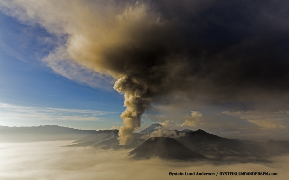
Mount Bromo in the regency of Probolinggo, East Java, has again erupted. According to the VONA (Observatory of the Volcano) page, the aviation color code for Mount Bromo is currently orange, or WASPADA. However, Mount Bromo is still safe to visit.
The eruption occurred Monday morning (11/3/2019). An eruption with volcanic ash clouds at 2:00 UTC (7:00 local time). Eruptions and ash emissions continue. The volcanic ash cloud is estimated at about 9,373 feet, or 2,929 meters above sea level.
VOLCANO OBSERVATORY NOTICE FOR AVIATION – VONA.
Issued: March 11 , 2019
Volcano: Bromo (263310)
Current Aviation Colour Code: ORANGE
Previous Aviation Colour Code: orange
Source: Bromo Volcano Observatory
Notice Number: 2019BRO02
Volcano Location: S 07 deg 56 min 31 sec E 112 deg 57 min 00 sec
Area: East java, Indonesia
Summit Elevation: 7453 FT (2329 M)
Volcanic Activity Summary:
Eruption with volcanic ash cloud at 14h00 UTC (07h00 local). Eruption and ash emission is continuing.
Volcanic Cloud Height:
Best estimate of ash-cloud top is around 9373 FT (2929 M) above sea level, may be higher than what can be observed clearly. Source of height data: ground observer.
Other Volcanic Cloud Information:
White brown and grey, thin to thick Ash-cloud moving to south-west-southwest
Remarks:
Seismic activity is characterized by continous volcanic tremor
Source : viva.co.id , Magma Indonésie .
Photo : Oystein Lund Andersen.
Peru , Sabancaya :
An average of 15 EXP / day was recorded. The activity associated with fluid movements (long period type) continues to predominate. On the other hand, earthquakes associated with the rise of magma (hybrid types) remain very few and low energy.
The columns of gas and eruptive ash reached a maximum height of about 2800 m above the crater. The dispersion of these materials occurred within a radius of about 20 km, mainly in the northwest, west and southwest directions.

The volcanic gas (SO2) flow recorded on March 3 a maximum value of 3360 tons / day, a value considered important.
The SNSE GNSS station, which measures volcanic information, has not recorded significant deformations.
According to the MIROVA system, four thermal anomalies have been recorded, with values of 1 to 12 MW VRP (Radiated Volcano Energy).
In general, eruptive activity maintains moderate levels. No significant changes are expected in the coming days.
Source : IGP Peru.
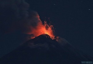
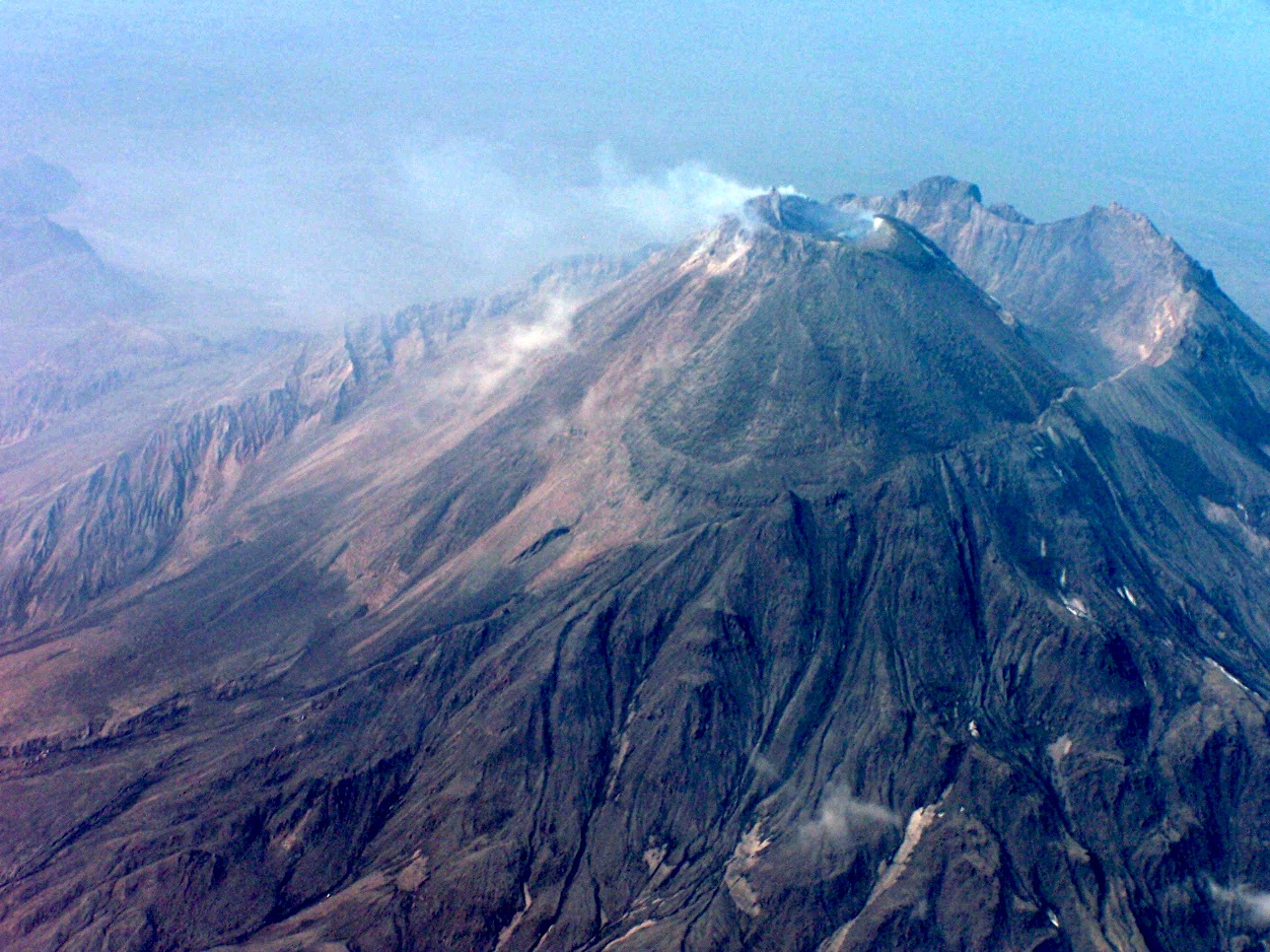
Kamchatka , Bezymianny :
VOLCANO OBSERVATORY NOTICE FOR AVIATION (VONA).
Issued: March 12 , 2019
Volcano:Bezymianny (CAVW #300250)
Current aviation colour code:ORANGE
Previous aviation colour code:orange
Source:KVERT
Notice Number:2019-60
Volcano Location:N 55 deg 58 min E 160 deg 35 min
Area:Kamchatka, Russia
Summit Elevation:9452.96 ft (2882 m)
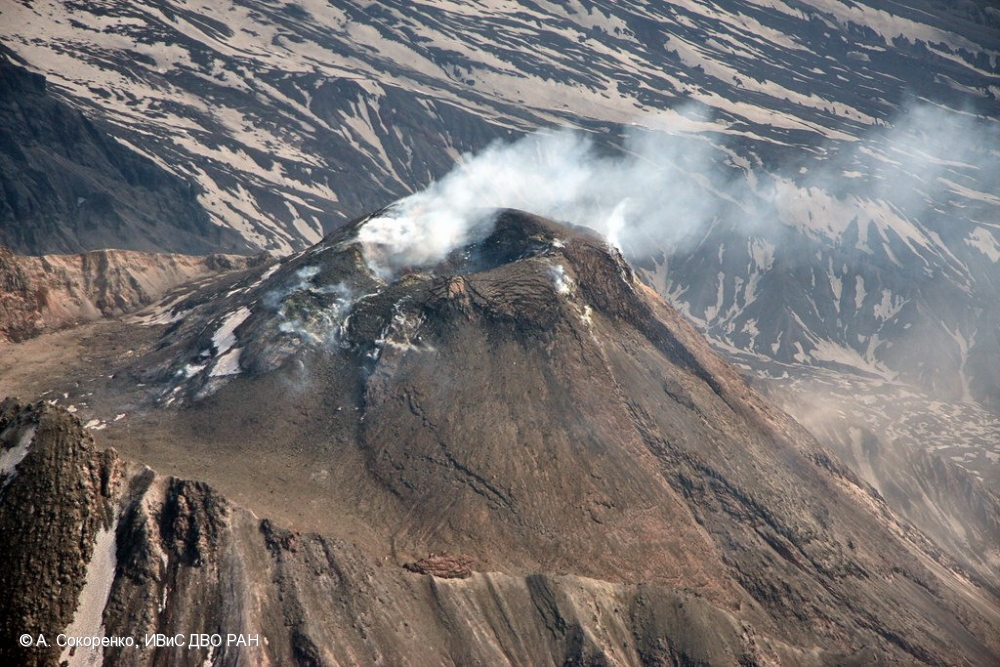
State of Bezymianny volcano on 05.06.2013
Volcanic Activity Summary:
Activity of the volcano continues to increasing. The incandescence of the volcano in the dark time, hot avalanches from lava dome top and sometimes a strong fumarolic activity were obserwing during the last week. Strong ash explosions up to 10-15 km a.s.l. could occur at any time during next week. KVERT continues to monitor Bezymianny volcano.
Activity of the volcano gradually increases. Strong ash explosions up to 32,800-49,200 ft (10-15 km) a.s.l. could occur at any time. Ongoing activity could affect international and low-flying aircraft.
Volcanic cloud height:
NO ASH CLOUD PRODUSED
Other volcanic cloud information:
NO ASH CLOUD PRODUSED
Prior to its noted 1955-56 eruption, Bezymianny had been considered extinct. The modern volcano, much smaller in size than its massive neighbors Kamen and Kliuchevskoi, was formed about 4700 years ago over a late-Pleistocene lava-dome complex and an ancestral edifice built about 11,000-7000 years ago. Three periods of intensified activity have occurred during the past 3000 years. The latest period, which was preceded by a 1000-year quiescence, began with the dramatic 1955-56 eruption. This eruption, similar to that of St. Helens in 1980, produced a large horseshoe-shaped crater that was formed by collapse of the summit and an associated lateral blast. Subsequent episodic but ongoing lava-dome growth, accompanied by intermittent explosive activity and pyroclastic flows, has largely filled the 1956 crater.
This volcano is located within the Volcanoes of Kamchatka, a UNESCO World Heritage property.
Source : Kvert , GVP.
Photo : A. Sokorenko, IVS FEB RAS, Pavel Izbekov / PIRE ( 2006)
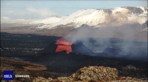
La Réunion , Piton de la Fournaise :
The volcanological observatory of the Piton de la Fournaise (OVPF) recorded seismicity again throughout the day on Sunday, after the eruption ended at 6:30 am the same day. It has since disappeared, which seems to indicate a real return to the calm of the volcano. The possibility of a resumption of activity is no longer on the agenda.
On Monday at dawn, 24 hours after the end of the eruption, incandescences were still visible at the level of the eruptive cone, at 1800 m altitude and in the Great Slopes at the mouth of lava tunnels that continue to drain . And 36 hours later, again, on Monday night, same thing. The same phenomenon had been observed many days after the end of the piton Jacob eruption, in September 2016, on the images relayed by the OVPF camera of the peak of Partage, the importance of the eruptive cone allowing a persistence of the heat.
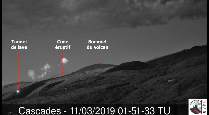
Scientists have planned field missions in the coming days, to collect data and take samples of the flows, while other members of the observatory will fly with the air force for two days to the Glorious (Mozambique Channel) to install a seismological station to complete the existing network to monitor the seismic activity underway since May 2018 in Mayotte related to volcanic activity.
Source : Clicanoo ( https://www.clicanoo.re/Societe/Article/2019/03/11/36-heures-apres-la-fin-de-leruption-la-lave-continue-de-couler_570001?fbclid=IwAR3ursLUueswYtxBsloiyqFj9FyYPItoKIYpB6HavihRwYBRddcSLhGo1SE )
Photo : OVPF
Costa Rica , Turrialba / Poas / Rincon de la Vieja :
Daily report on the state of volcanoes. Date: 10 March 2019, Updated at: 11:05:00.
Turrialba Volcano:
Since March 9, 2019, the Turrialba volcano has been erupting continuously. The column rises to 1,000 meters altitude and 4,340 meters above sea level. (14235.2 ft).
The seismic activity is more important compared to the day yesterday.
At the time of writing, winds are blowing from the north
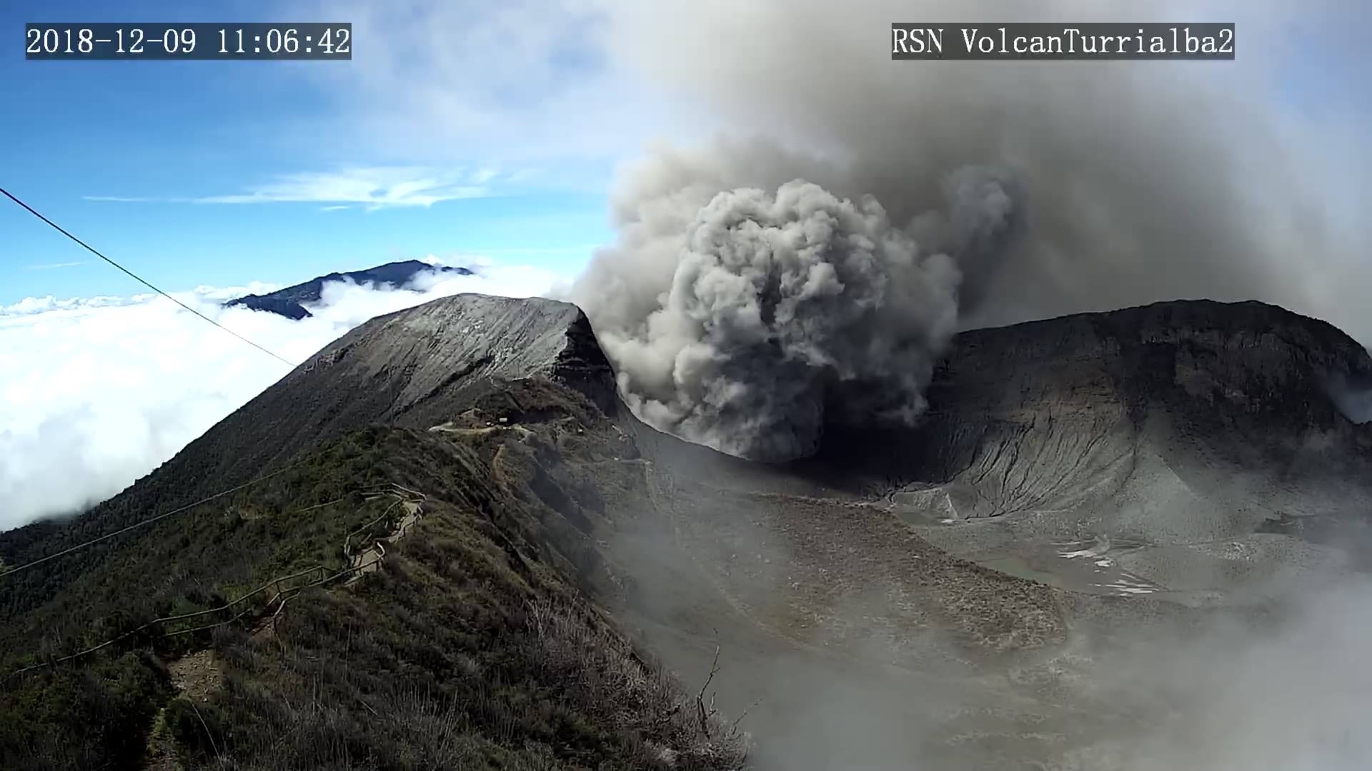
The height of the vapor plume, aerosols and magmatic gases fluctuates between 500 and 1,000 meters above the summit of the volcano. There are sporadic LP-type earthquakes and short-lived, low-amplitude tremors associated with the intermittent release of small amounts of ash into the environment. NASA’s AURA satellite IMO instruments continue to detect emissions of sulfur dioxide, SO2, into the atmosphere, but in significantly lower quantities than those detected by satellites between 2016 and 2018.
Poas Volcano:
Since March 9, 2019, there has been a continuous eruption of the Poas volcano, with a column that rises 500 meters above the crater height and 3208 meters above sea level (10522.24 ft).
The seismic activity is lower compared to the day yesterday.
At the time of this report, winds are blowing from the southwest.
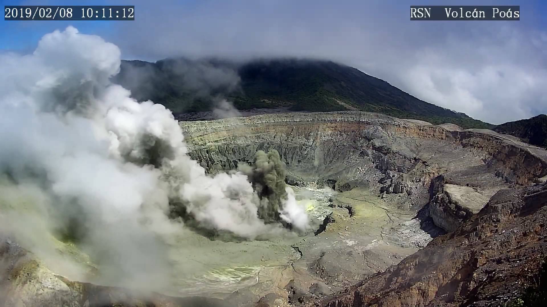
The height of the plume of water vapor, aerosols and magmatic gases fluctuates between 300 and 500 meters above the crater. Some low amplitude LP volcanic earthquakes associated with sporadic and small ash emissions are recorded. Since March 8, 2019, the permanent MultiGAS system for controlling the composition of gases near the west vents of the crater bottom has recorded in the plume a significant decrease in the concentration of magmatic sulfuric gases. (SO2 less than 5 ppm, CO2 / SO2 greater than 1.2 and H2S / SO2 less than 0.3), as well as a slight increase in the proportion of gaseous carbon dioxide, CO2. This indicates a predominance of the hydrothermal system over the magmatic system since the magma that was extruded in 2017 loses gas, cools and gradually crystallizes.
Rincon de la Vieja Volcano:
No eruption is reported.
The seismic activity is lower compared to yesterday.
At the time of this report, the winds are blowing to the northwest.
The level of seismic activity is generally low and stable. There were no LP-type earthquakes or tremors in the last 24 hours.

The heavy rains of the last days transported materials that had been deposited several weeks ago in the upper and middle parts of the northern flank of Rincón, through the rivers Azul, Quebrada Azufre, and Penjamo.
Source : OVSICORI-UNA
Photos : RSN , RSN , Federico Chavarría-Kopper – Ovsicori