November 07 , 2018.
Alaska , Veniaminof :
56°11’52 » N 159°23’35 » W,
Summit Elevation 8225 ft (2507 m)
Current Volcano Alert Level: WATCH
Current Aviation Color Code: ORANGE
Veniaminof volcano continues to erupt, with minor lava spattering, effusion of a lava flow from the cone in the ice-filled summit caldera, and continuous, low-amplitude seismic tremor. Satellite views of the volcano over the past day showed elevated surface temperatures from the active lava effusion. A new high resolution image shows that the current lava flow extends 1.2 km (0.75 mi) from the vent. A diffuse ash plume up to 12,000 ft and drifting to the northeast was visible in satellite images throughout the day and reported by a pilot at 22:51 UTC (13:51 AKST) on November 5. Trace ashfall is possible in nearby communities under favorable wind conditions.
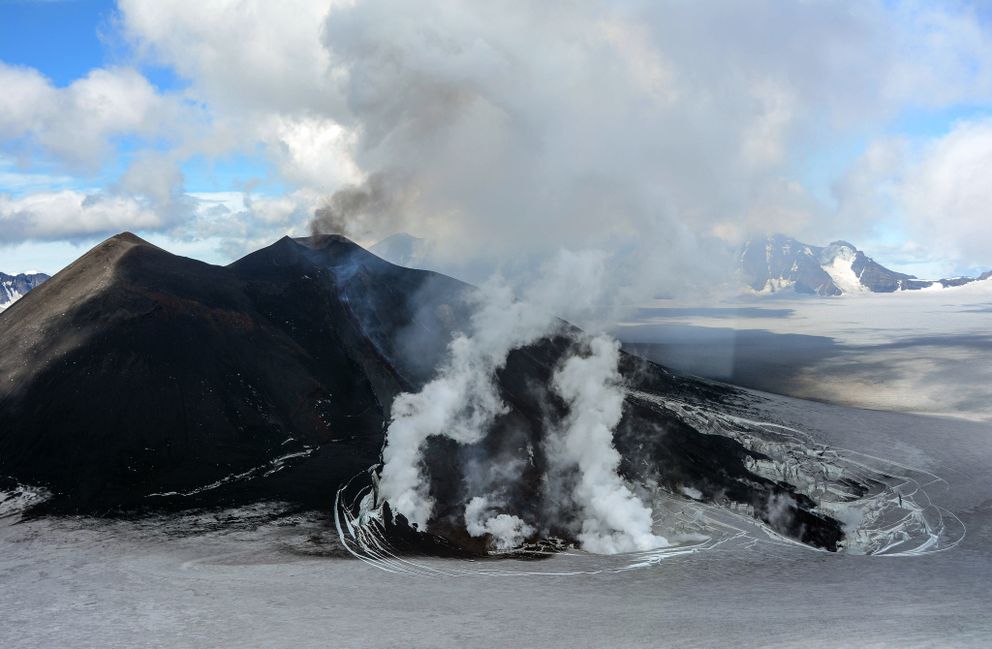
Veniaminof volcano is monitored with a local real-time seismic network, which will typically allow AVO to detect changes in unrest that may lead to a more significant explosive eruption. Rapid detection of such an event would be accomplished using a combination of seismic, infrasound, lightning, and satellite data.
Source : AVO.
Photo : Waythomas, C. F.( juillet 2013)
Colombia , Chiles / Cerro Negro :
Weekly activity bulletin of volcanoes Chiles and Cerro Negro.
The activity level of the volcanoes is maintained at the level: YELLOW LEVEL ■ (III): CHANGES IN THE BEHAVIOR OF THE VOLCANIC ACTIVITY
Following the activity of the CHILE volcanoes and CERRO NEGRO, the COLOMBIAN GEOLOGICAL SERVICE (SGC) reports that:
Between October 30 and November 5, 2018, seismic activity in the Chile – Cerro Negro volcano region recorded a total of nearly 2,600 earthquakes, a slight decrease from the previous week. and with an average of about 370 events per day.
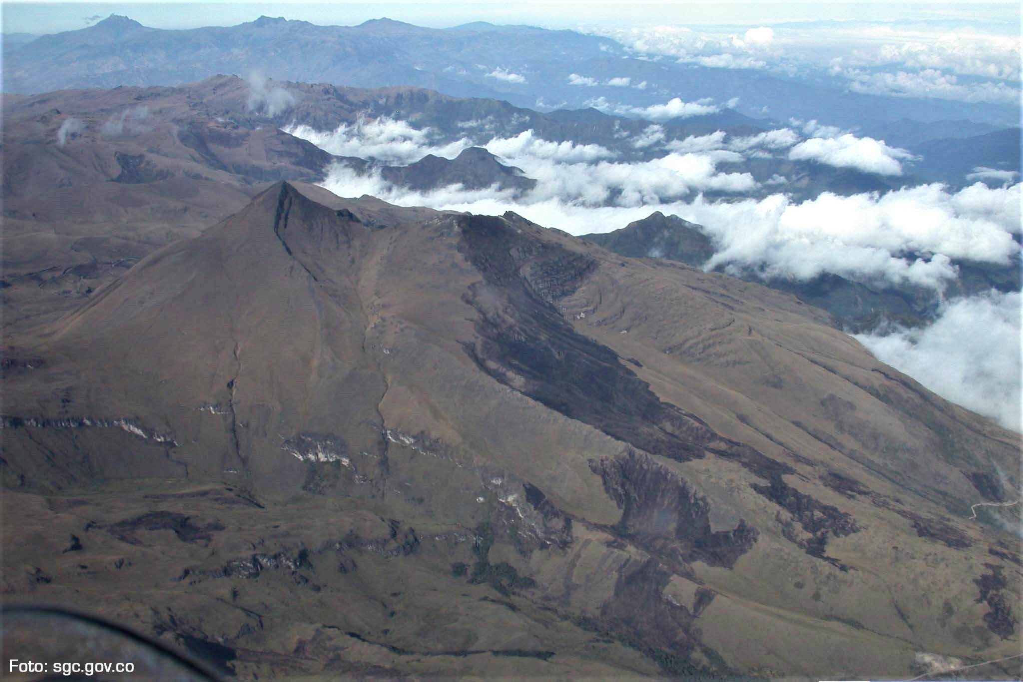
The predominance of seismicity related to the fracturing of the rock inside the volcanic building (volcano-tectonic earthquakes) is maintained. The earthquakes were mainly located in the south and south-west of the Chiles volcano, at distances of up to 5 km, depths between 2 and 6 km from the summit (4700 m altitude) and a maximum local magnitude of 1 , 7 on the Richter scale.
The Colombian Geological Service and the Institute of Geology of the National Polytechnic School of Ecuador closely monitor the evolution of this seismic activity and the volcanic phenomenon and inform in a timely manner on the detected changes.
Source : SGC
Photo : SGC
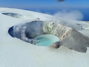
Chile , Villarica :
VOLCÁN VILLARRICA – TUESDAY 6 NOVEMBER
Native name: Quitralpillán
Structure: Caldera-stratovolcan complex
Morphological units: Villarrica I, II and III
Geographical coordinates: 39º25.01S, 71º57.87W
Surface area: 400 km2
Elevation: 2847 meters above sea level
Crater diameter: 200 meters
Adventif eruptive centers: More than 30, some very well preserved
Types of historical lava: Basaltic, basaltic-andesitic
Types of historical eruptions: Hawaiian, phreato-magmatic, vulcanian and strombolian
Last eruption: 2015
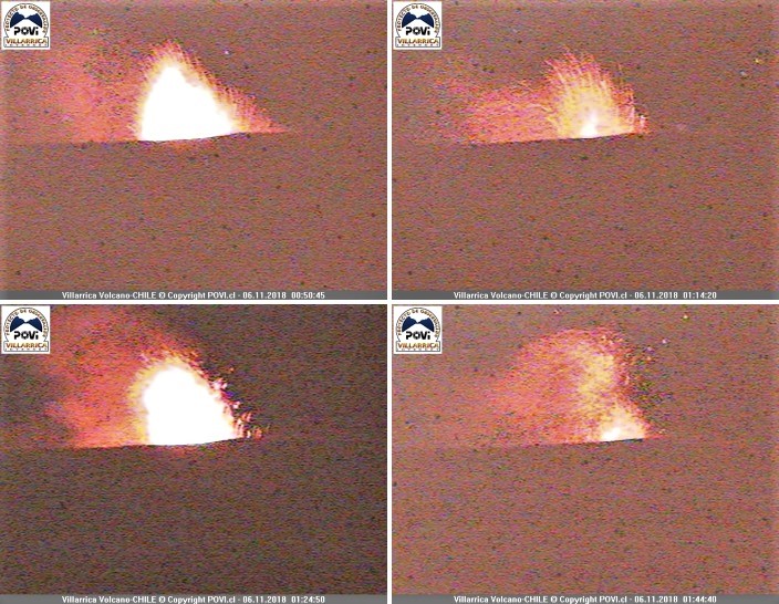
Strombolian explosions eject lava splashes up to about 80 meters high on the edges of the summit. Impact of pyroclasts on the perimeter of the crater.
In mid-February 2017, behavior with similar characteristics was observed.
Source : Werner Kaller / Povi.
Guatemala , Fuego :
SPECIAL BEFGO VULCANOLOGICAL BULLETIN # 199-2018, EFUSEOUS ERUPTION, Guatemala 6 November 2018, 22:00 hours (local time).
Type of activity: Vulcanian
Morphology: Composite Stratovolcano
Geographical location: 14 ° 28’54˝ N Latitude; 90 ° 52’54˝ Longitude W.
Height: 3,763msnm.
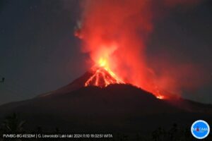
The effusive activity of the Fuego volcano is maintained, the lava flow is approximately 1000 m long, directed to the southwest, it descends into the Ceniza canyon, incandescence is observed due to the lava flow, avalanches in the area of the flow front due to the movement of the flow.
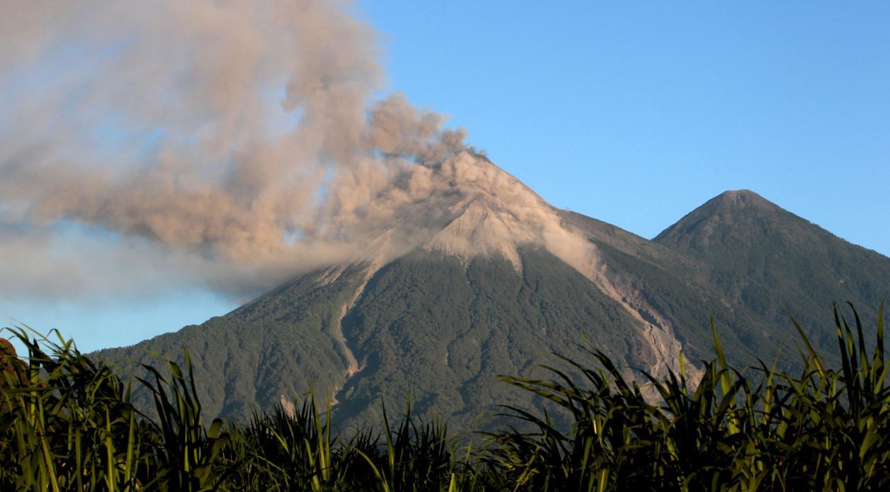
The vibration of the volcanic cone translated into tremor has considerably decreased, as evidenced by the RSAM graph. This generates weak to moderate explosions that emit columns of ash at an altitude of 4800 meters that disperse 12 to 15 km to the southwest and west. Low to moderate sounds similar to those of a locomotive can be heard in 8 to 14 minutes. Incandescent pulses are observed at 150 – 200 m altitude with moderate avalanches on the crater contour. Ash particles fall in the areas of Panimache I, Morelia, Santa Sofia, Sangre de Cristo, Palo Verde Estate, and so on.
At the present time, seismicity has decreased, however, the possibility that new lava flows are generated in the different ravines, as well as events with pyroclastic flows that can be channeled into any of the canyons of the Fuego volcano, are not excluded. It is necessary to pay attention to these sudden changes.
Source : Insivumeh
Photo : emisorasunidas.com.
Hawaï , Kilauea :
Tuesday, November 6, 2018, 3:56 PM HST (Wednesday, November 7, 2018, 01:56 UTC)
19°25’16 » N 155°17’13 » W,
Summit Elevation 4091 ft (1247 m)
Current Volcano Alert Level: ADVISORY
Current Aviation Color Code: YELLOW
Activity Summary:
Kīlauea Volcano is not erupting. Rates of seismicity, deformation, and gas release have not changed significantly over the past week. Deformation signals are consistent with refilling of the middle East Rift Zone.
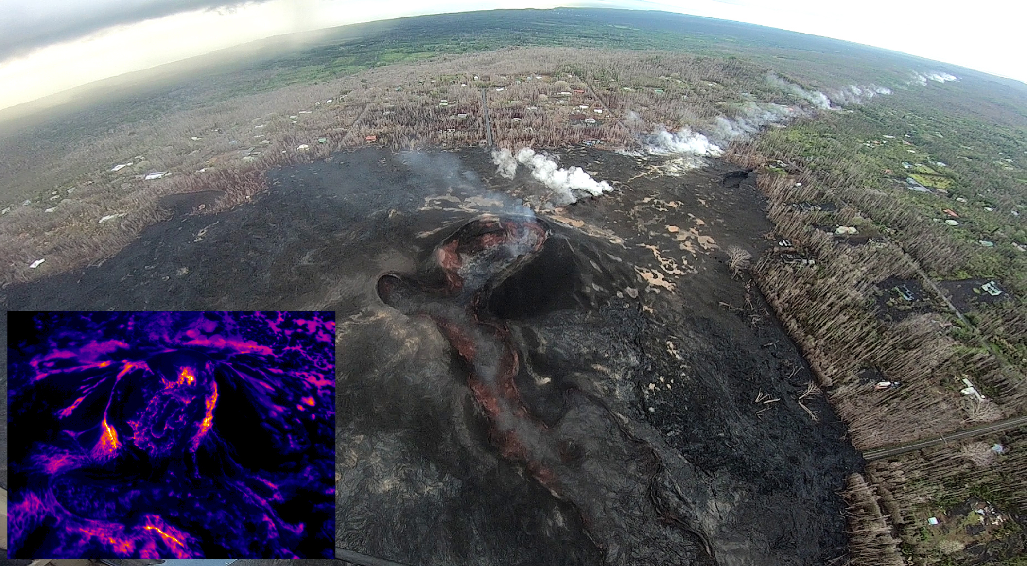
This wide-angle photo shows the fissure 8 cone (center of image) and the long line of steaming areas extending uprift (west), towards the upper right corner of the image. No significant change was observed at fissure 8 during today’s overflight. Thermal images (see inset lower left) show no signs of lava within the cone – the small collapse pit in the center of the crater floor is cold.
Observations:
HVO monitoring during the past week shows low rates of seismicity at the summit and East Rift Zone (ERZ). Earthquakes continue to occur primarily at Kīlauea’s summit area and south flank, with continued small aftershocks of the magnitude-6.9 quake on May 4, 2018. Seismicity remains low in the lower ERZ.
In the ERZ, tiltmeters near Puʻu ʻŌʻō and farther east continue to record an inflationary trend, consistent with refilling of the middle East Rift Zone. At the summit, tiltmeters have recorded a slight inflationary trend.
Sulfur dioxide gas emissions at the summit averaged 50 tonnes/day as reported on October 24, and 75 tonnes/day at Puʻu ʻŌʻō on October 23. There was no sulfur dioxide detected by our instruments in the lower ERZ.
Hazards are still present in the lower East Rift Zone (LERZ) eruption area and at the Kīlauea summit. Residents and visitors near recently active fissures and lava flows should stay informed, heed Hawaii County Civil Defense and National Park warnings, and be prepared, if necessary, to self-evacuate in the unlikely event of renewed activity. Please note that Hawaii County maintains a closure of the entire flow field and the vents and prohibits access to the area unless authorized through Civil Defense.
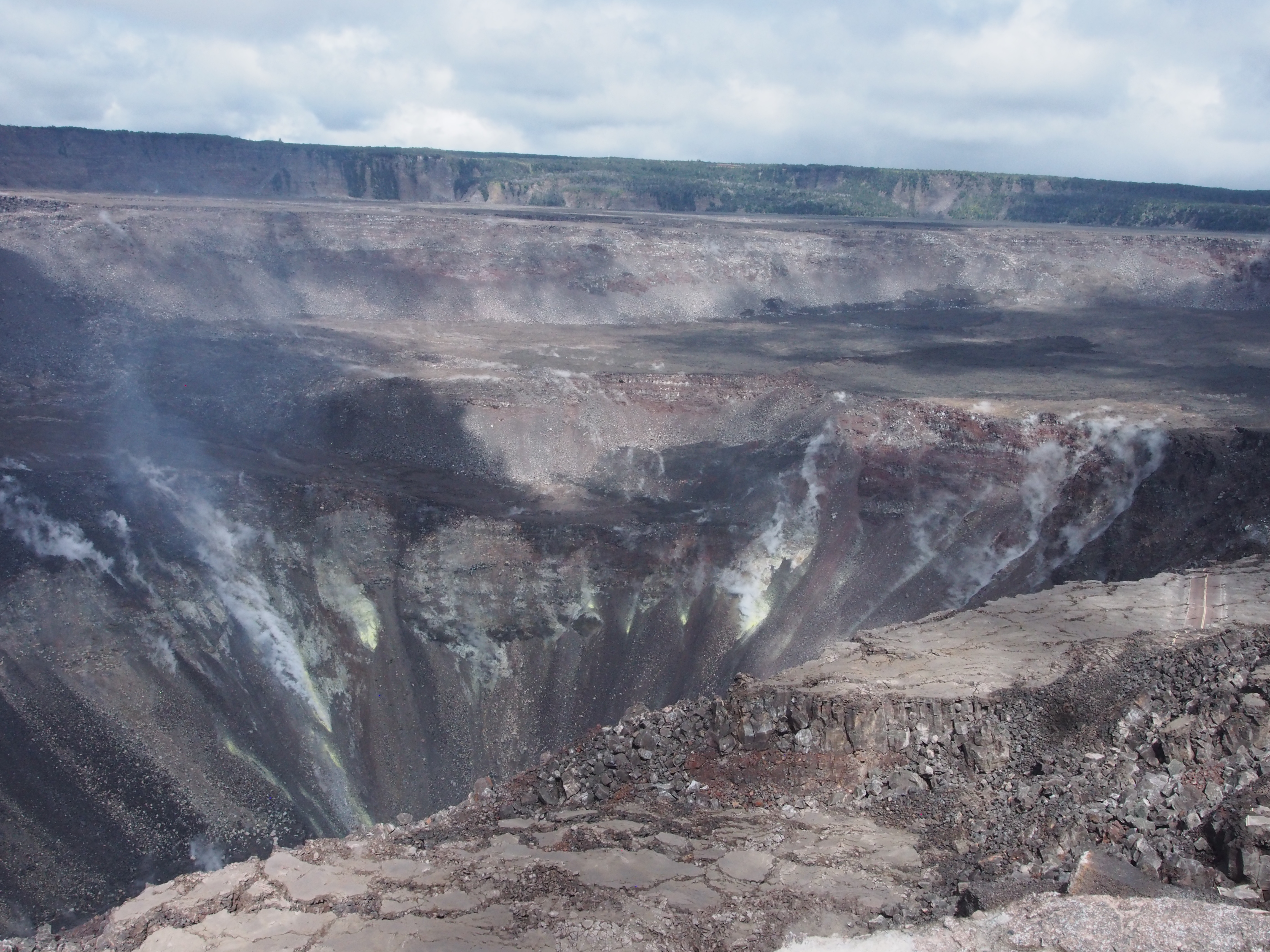
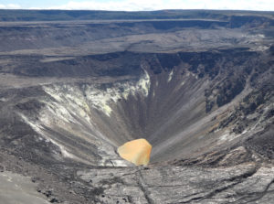
Kīlauea Volcano’s summit, as viewed from the southwest, shows the collapsed area of Halema‘uma‘u and the adjacent caldera floor. A section of Crater Rim Drive preserved on a down-dropped block is visible at the far right. Volcanic gases rising from magma stored beneath the summit continue to escape to the surface, as they have for as long as Kīlauea has existed, resulting in deposits of sulfur on the crater walls.
The Hawaiian Volcano Observatory (HVO) continues to closely monitor Kīlauea’s seismicity, deformation, and gas emissions for any sign of reactivation, and maintains visual surveillance of the summit and the East Rift Zone. HVO will continue to issue a weekly update (every Tuesday) and additional messages as warranted by changing activity.
Source : HVO
Photos : HVO