October 06 , 2018.
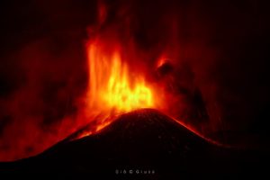
La Réunion , Piton de la Fournaise :
Activity Bulletin from Friday, October 5, 2018 at 16:30 (local time).
The eruption started on September 15th at 4:25 am local time continues. The intensity of the volcanic tremor (indicator of the eruptive intensity at the surface) is always sharply increasing since October 3 at 22h local time (18h UTC).
This increase could be related to the gradual closure of the entire feeding system, from the dike (« feeding duct » of the eruption) to the eruptive cone, favoring a phenomenon of « resonance » more important.
Piston gases (« gas flushes » or « tremor puffs ») at the eruptive site are always recorded by the OVPF seismometers. These « piston gases » mark a change of regime in the degassing of the eruption, and are generally observed when the quantity of available gas is exhausted, and often synonymous with a decrease of activity on the surface.
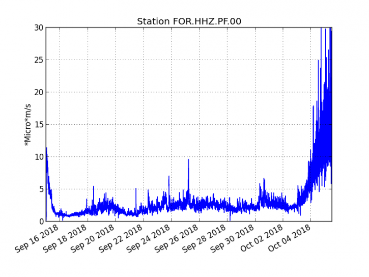
Figure 1: Evolution of the RSAM (indicator of the volcanic tremor and the intensity of the eruption) between 04:00 (00h UTC) September 15 and 16:00 (12:00 UTC) October 5 on the FOR seismic station, located near the crater Chateau Fort (2000 m altitude on the southeast flank of the terminal cone). (© OVPF / IPGP)
– No volcano-tectonic earthquake was recorded during the day of 4 October, nor during the current day.
– An inflation (swelling) of the building, witnessing the influence of a source of pressure at the foot of the volcano, is still perceptible.
– The surface flow rates could not be estimated today because of lava flows that are too weak at the surface.
– The surface activity is still very limited with very rare lava projections inside the cone and no major resurgence visible from the main tunnel. Most of the activity now continues almost exclusively in lava tunnels.
Alert level: Alert 2-2 – Eruption in the Enclos .
Source : OVPF
Alaska , Veniaminof :
56°11’52 » N 159°23’35 » W,
Summit Elevation 8225 ft (2507 m)
Current Volcano Alert Level: WATCH
Current Aviation Color Code: ORANGE
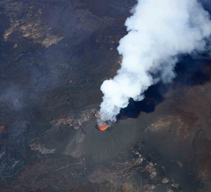
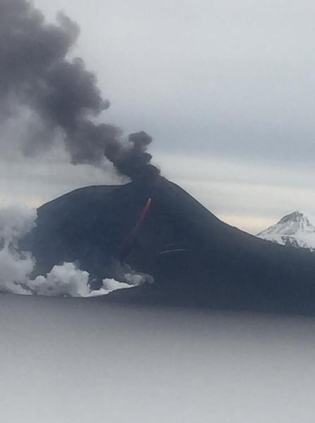
Low-level eruptive activity continues at the intracaldera cone of Veniaminof volcano. Relatively continuous seismic tremor has been occurring throughout the week. This type of seismicity suggests that effusion of lava on the south flank of the intracaldera cone is continuing. A clear satellite image obtained on Oct. 3 indicates that the lava flow was about 1000 m (0.6 mi) in length. No significant ash emissions have been detected in satellite imagery or reported in nearby communities this week. Views of the volcano from the FAA web camera in Perryville recorded incandescence on October 2, but since then clouds have obscured views of the volcano. Satellite data have shown elevated surface temperatures throughout the week. Slightly above background sulfur dioxide gas emissions were detected yesterday (10/4/18) in satellite data.
Mount Veniaminof volcano is an andesitic stratovolcano with an ice-filled 10-km diameter summit caldera located on the Alaska Peninsula, 775 km (480 mi) southwest of Anchorage and 35 km (22 mi) north of Perryville. Veniaminof is one of the largest (~300 cubic km; 77 cubic mi) and most active volcanic centers in the Aleutian Arc and has erupted at least 13 times in the past 200 years. Recent significant eruptions of the volcano occurred in 1993-95, 2005, and 2013. These were Strombolian eruptions that produced lava fountains and minor emissions of ash and gas from the main intracaldera cone. During the 1993-95 activity, a small lava flow was extruded, and in 2013, five small lava flows effused from the intracaldera cone over about five months. Minor ash-producing explosions occurred nearly annually between 2002 and 2010. Previous historical eruptions have produced ash plumes that reached 20,000 ft above sea level (1939 and 1956) and ash fallout that blanketed areas within about 40 km (25 mi) of the volcano (1939).
Source : AVO
Photo : Lopez, Jesse
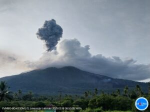
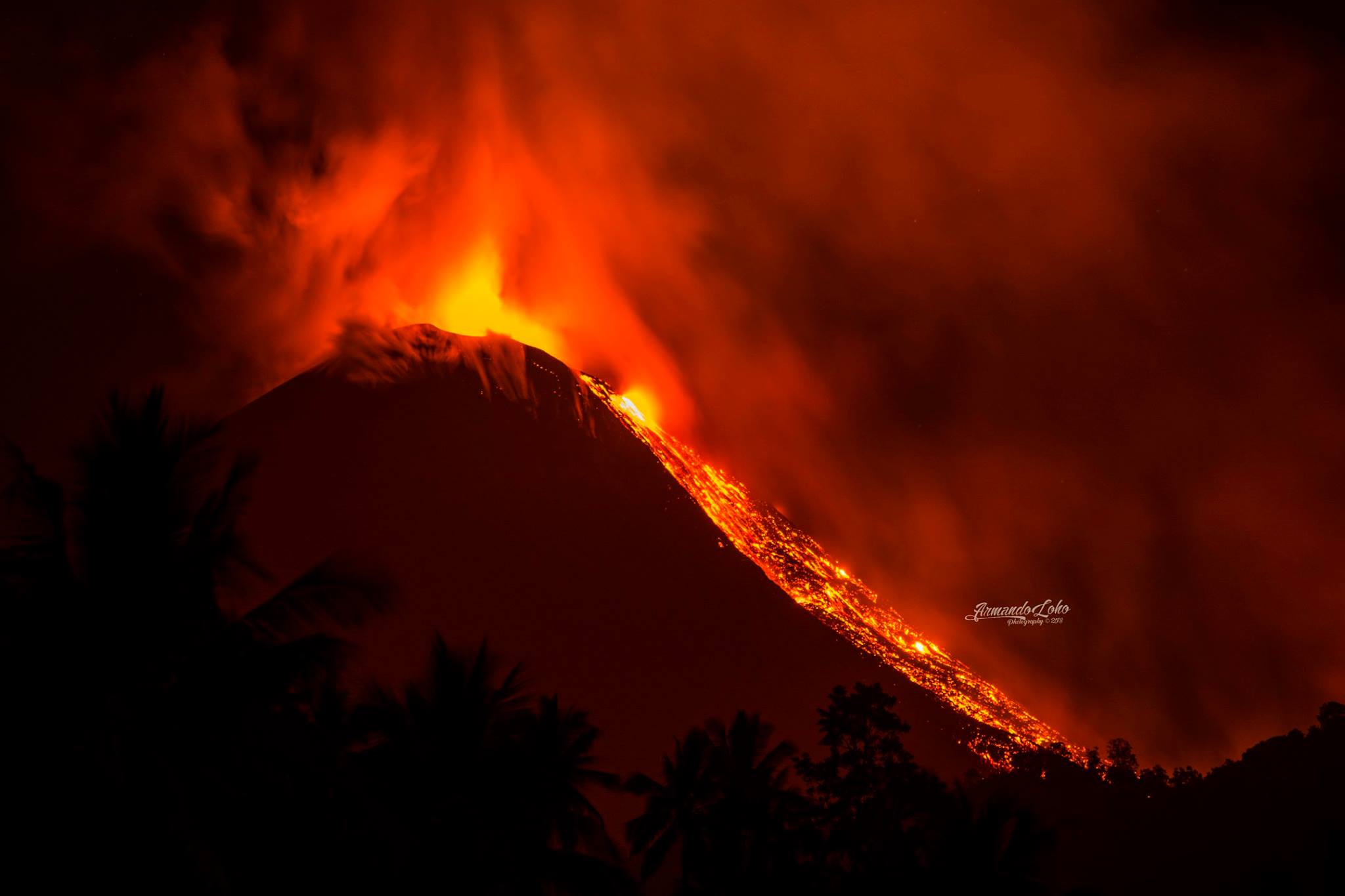
Indonesia , Soputan :
Level of activity at Level III (SIAGA). The volcanic activity of Soputan (1784 m above sea level) increased: from yesterday until this morning, the volcano visually was cleared until it was covered with fog, the smoke column from the crater was white up to 200 m above the summit. The wind was weak in the northwest.
Thanks to the seismographic recordings, on October 5, 2018, it was noted:
95 avalanche earthquakes
60 emission earthquakes.
4 deep volcanic earthquakes
3 distant tectonic earthquakes
A continuous tremor with a maximum amplitude of 0.5 to 5 mm and a dominant value of 2 mm.
Recommendation: Communities should not be active within 4 km of the summit of Mount Soputan or in a west-southwest section of 6.5 km, which is a crater opening area, to avoid the risk of avalanches of lava and avalanches of hot clouds.
VONA: The latest VONA code sent the color code ORANGE, issued October 4, 2018 at 6:36 am, related to an eruption with a column height of ashes of 3309 m above sea level or about 1500 m at above the summit, the wind was blowing West – Southwest.
Source : PVMBG.
Photo : Armando Loho Photography / Sherine France , Facebook.
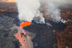
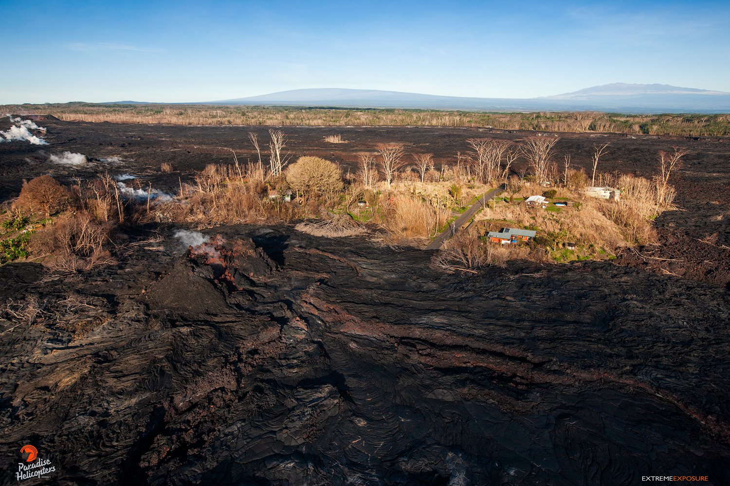
Hawaï , Kilauea :
HVO/USGS Volcanic Activity Notice
Current Volcano Alert Level: ADVISORY
Previous Volcano Alert Level: WATCH
Current Aviation Color Code: YELLOW
Previous Aviation Color Code: ORANGE
Issued: Friday, October 5, 2018, 8:47 AM HST
Source: Hawaiian Volcano Observatory
Notice Number:
Location: N 19 deg 25 min W 155 deg 17 min
Elevation: 4091 ft (1247 m)
Area: Hawaii
Volcanic Activity Summary: It has been 30 days since lava has been active at the surface of Kīlauea Volcano. HVO monitoring shows low rates of seismicity, steady, relatively low rates of deformation across the volcano, and only minor gas emission at the summit and East Rift Zone (ERZ). These observations indicate that resumption of eruption or summit collapse is unlikely in the near-term.
Accordingly, HVO is lowering the Volcano Alert Level for ground based hazards from WATCH to ADVISORY. This means volcanic activity has decreased significantly but continues to be closely monitored for renewed activity. The Aviation Color Code is also being lowered from ORANGE to YELLOW.
Hazards are still present in the lower East Rift Zone (LERZ) eruption area and at the Kīlauea summit. Residents and visitors near recently active fissures and lava flows should stay informed, heed Hawaii County Civil Defense warnings, and be prepared, if necessary, to self-evacuate in the unlikely event of renewed activity. Please note that Hawaii County maintains a closure of the entire flow field and the vents and prohibits access to the area unless authorized through Civil Defense.
Remarks: Background and Prognosis
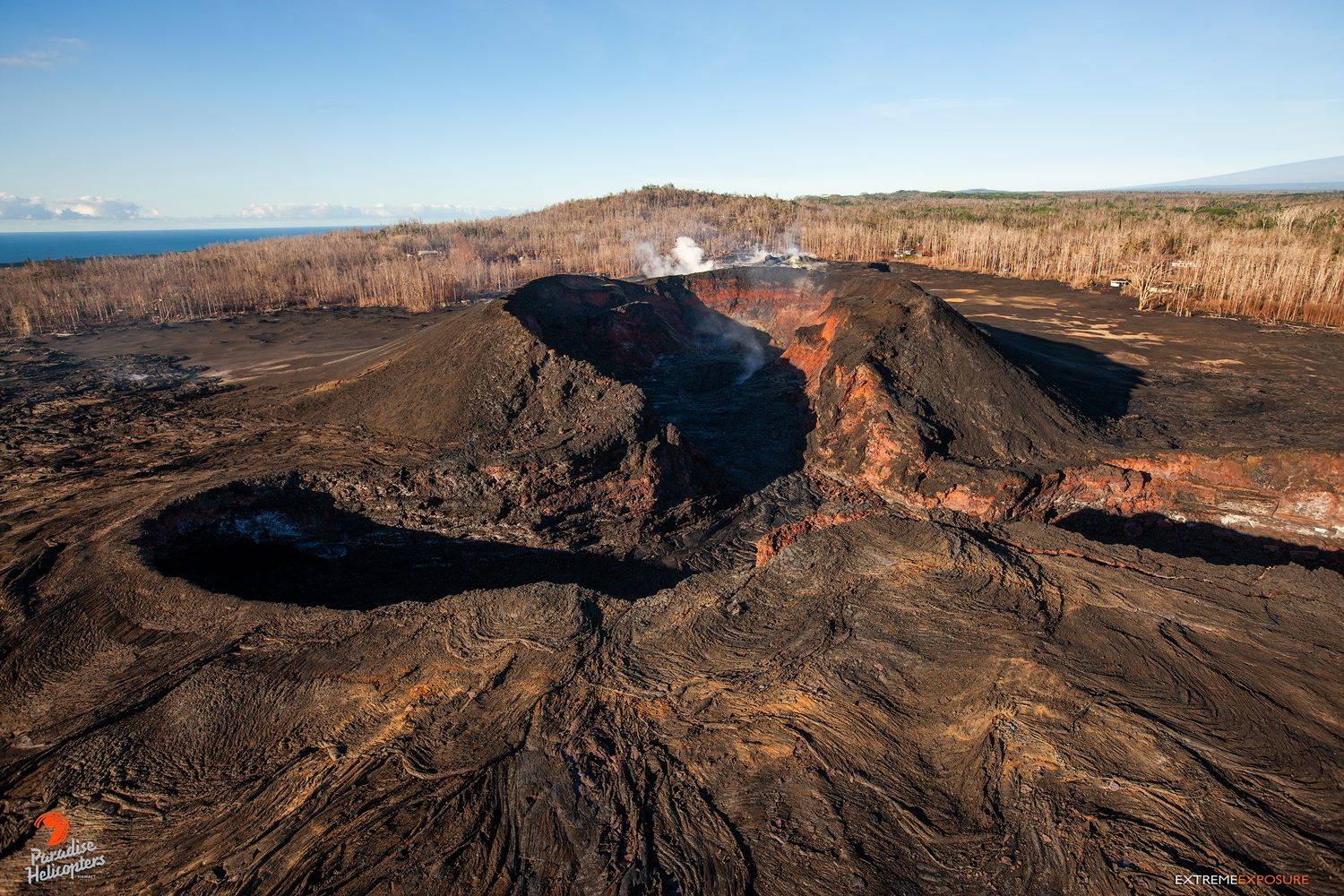
Kīlauea Volcano has maintained a low level of activity over the past two months. The last summit collapse was on August 2, 2018. High rates of seismicity and deflationary deformation at the summit stopped abruptly on August 4, coincident with cessation of major eruptive activity in the LERZ. Lava ceased flowing in the upper portion of the fissure 8 channel system by August 6, and ocean entries were inactive in late August. Active lava was last seen inside the fissure 8 cone on September 5. The total sulfur dioxide (SO2) emission rate from the summit, Puʻu ʻŌʻō, and LERZ fissure vents combined is currently less than 300 tonnes per day.
Seismicity remains low across the volcano. Ground deformation continues, but at rates well below those during the period of major eruptive activity this summer. An exception is within the middle East Rift Zone where data show evidence of reinflation between Puʻu ʻŌʻō and Highway 130. One interpretation of this signal is that the rift zone is refilling with magma following withdrawal during the 2018 eruption. An increase in this refilling rate or other change could result in new eruptive vents along any portion of the East Rift Zone.
While it is impossible to say with certainty what Kīlauea will do next, current monitoring data do not suggest a return to eruptive activity or summit collapse in the near term. HVO continues to closely monitor incoming geologic, seismic, deformation, and gas data for evidence of significant magma shallowing or pressurization that could mean the system was building toward renewed activity.
This change in activity marks the first time since 1986 that lava has not been active at Kīlauea’s surface for a period of 30 or more days (The last long pause was 48.5 days between episodes 39 and 40 of the Puʻu ʻŌʻō eruption.) In the past 200 years, the volcano has experienced periods of quiet ranging from months to years with no eruptive activity. However, Kīlauea is one of the most active volcanoes in the world, and additional eruptions will occur.
Source : HVO
Photos : Bruce Omori