July 22 , 2018.
Chile , Villarica :
Volcano VILLARRICA – FROM JULY 16 TO 20
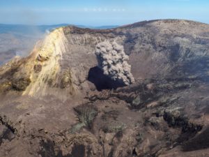
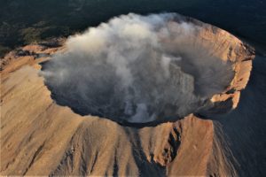
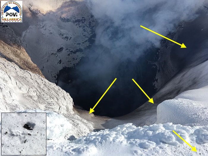
A reconnaissance of the crater of Villarrica volcano, carried out yesterday, July 20th, made it possible to know the level of the lava pit. After 8 months, it is again possible to observe sources and splash of lava on the edges of the crater.
According to what was published by POVI this week, Monday, July 16, the volcano began to emit plumes of water vapor and gas, as has been observed several times. That day, at 10:47, a powerful steam emission was recorded that contained particulate materials, ashes and lapilli. Some pyroclasts were deposited on the inner walls of the crater O-N-E, and some specimens on the edges.
We interpret this particular event as the announcement of a change in the behavior of the volcano, which for 8 months has shown very low activity indices, and that it would be associated with a type of system stress.
Subsequently, on Wednesday, July 18, at about the same time and in a few minutes, 2 more emissions of vapor and gas were captured, containing a smaller volume of particles than on the 16th. hours and 12 hours, one of the satellites of the European Space Agency (ESA) has captured a hot surface on the crater, about 87 x 96 meters (the crater diameter is 200 m). This is the largest area of heat since December 2017. Later, already dark, the images of our highest gain camera revealed that the source of the incandescence – the lava pit – is located more superficially than the previous months.
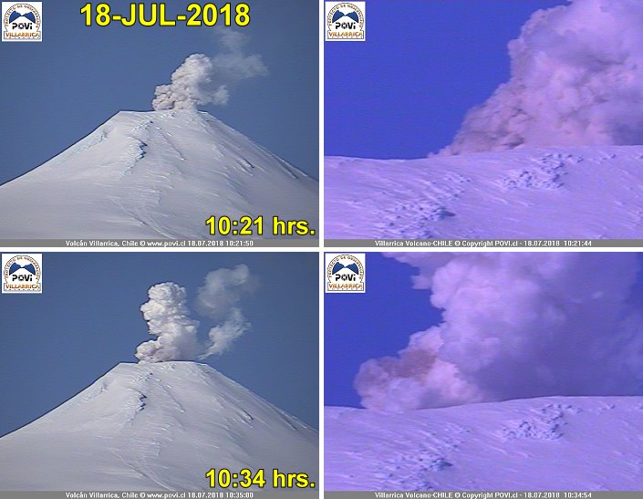
In the early morning of day 20, steam and gas emissions decreased, and a few hours later, around 6:27 am, our seismograph, located 8 km from the crater, recorded a small earthquake, the characteristics of which would classify it as volcano-tectonic type (VT). We can not provide more information because we do not have a network of equipment to locate epicenters and hypocenters.
Since POVI has been studying Villarrica (since 1996), the described behavior has been documented several times, without significantly modifying the associated hazard.
Compared to 2015, 2016 and 2017, the seismic energy remains low (source: POVI seismograph) and the LP (long period) type signals, associated with repeated explosions of gas bubbles on the surface of the lava pit, are still absent.
Each volcano has a character and an individual story. The Villarrica, having its conduit open, usually delivers signals all the time. This week showed the stress that the lava was rising in the chimney. We hope that the level reached will remain stable and that we will be able to resume the most important study for us: the behavior of the lava pit.
Source : Werner Keller , Equipo POVI / Fundación Volcanes de Chile
Hawaï , Kilauea :
Saturday, July 21, 2018, 9:23 AM HST (Saturday, July 21, 2018, 19:23 UTC)
19°25’16 » N 155°17’13 » W,
Summit Elevation 4091 ft (1247 m)
Current Volcano Alert Level: WARNING
Current Aviation Color Code: ORANGE
Kīlauea Volcano Lower East Rift Zone
Fissure 8 continues to erupt lava into the channel leading northeastward from the vent. Overnight UAV flights were grounded due to weather. The most vigorous ocean entry is located a few hundred meters northeast of the southern flow margin with a few tiny pahoehoe toes were entering the ocean from the Kapoho Bay lobe to the north. The southern margin of the flow remains about 500 m (0.3 mi) from the boat ramp at Isaac Hale Park.
No other fissures are active this morning.
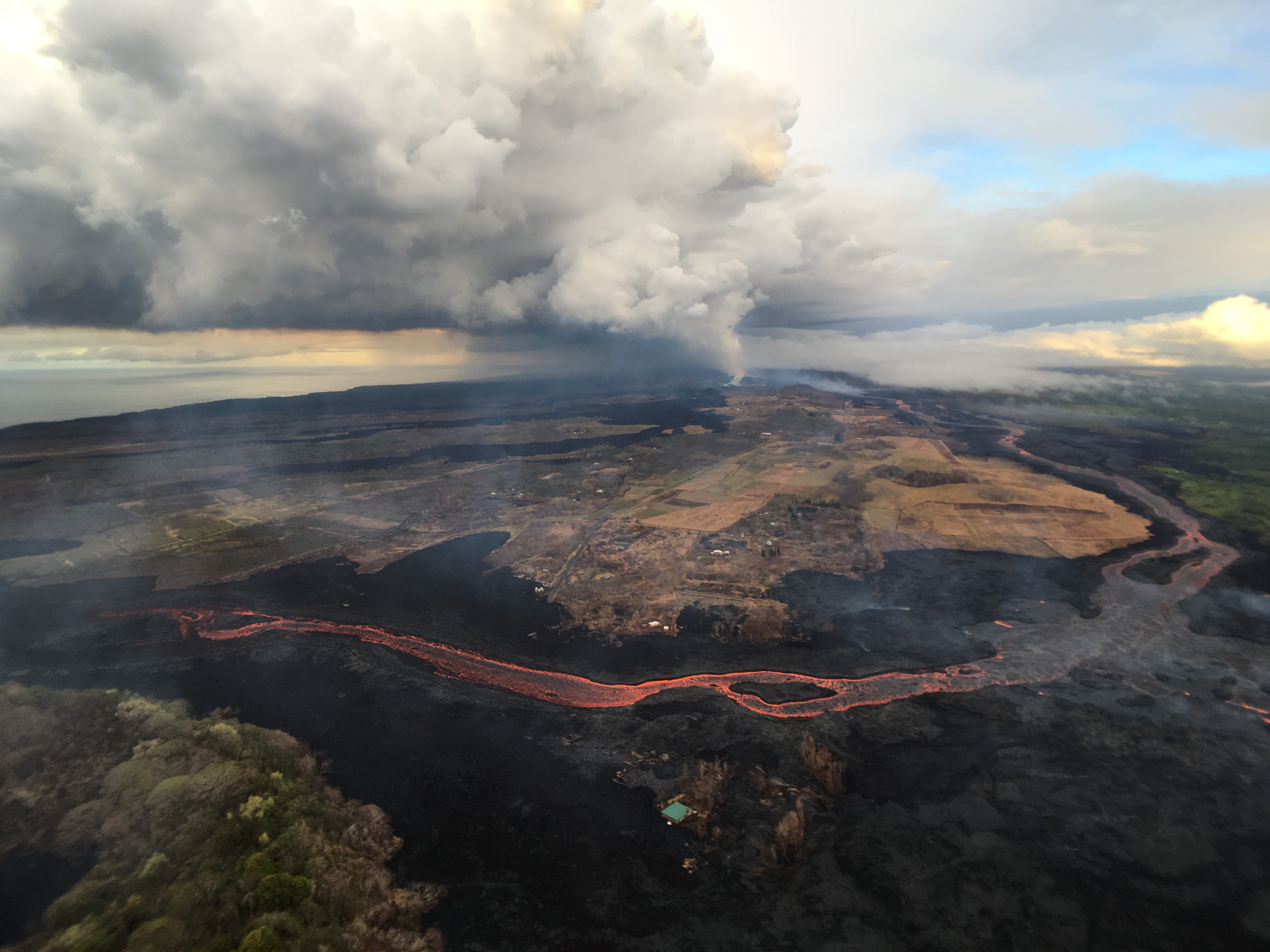
Fissure 8, source of the white gas plume in the distance, continues to erupt lava into the channel heading northeastward from the vent. Near Kapoho Crater (lower left), the channel turns south, sending lava toward the coast, where it enters the ocean in the Ahalanui area (shown in adjacent photo). Channel overflows are visible in the lower right.
Kīlauea Volcano Summit
The last collapse event occurred at 4:36 p.m. HST Thursday (July 19). Seismicity at the summit decreased immediately following the event and is now back to 20-35 earthquakes per hour. The next collapse event is expected this morning.
Source : HVO.
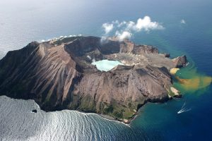
Ecuador / Galapagos , Sierra Negra :
4.5 degree earthquake in the Ecuadorian Galapagos Archipelago.
An earthquake of magnitude 4.5 was recorded today on Isabela Island, the largest in the Ecuadorian archipelago of the Galapagos, where the Sierra Negra volcano erupted last month, the Institute reported. geophysics (IG) of the École Polytechnique.
The IG detailed in its social networks that the earthquake occurred at 11:35 local time (16:35 GMT) at 0.81 degrees South latitude, at 91.13 degrees West longitude, 1 kilometer deep and 21.97 degrees West. kilometers from Puerto Villamil.
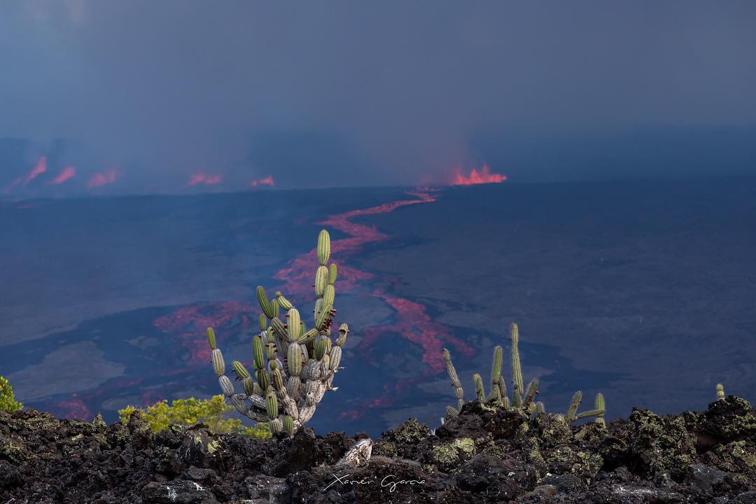
In his Twitter profile, he pointed out that the Sierra Negra volcano on Isabela Island maintains a « high » level of surface activity.
The Sierra Negra volcano, which erupted on June 26, has a large crater 10 kilometers in diameter that has already recorded this type of behavior in 1979 and 2005.
The Galapagos are formed by thirteen islands that have several volcanic buildings, the most important on Isabela and its neighbor Fernandina.
The Galapagos Archipelago was declared in 1978 as the Natural Heritage of Humanity by the United Nations Educational, Scientific and Cultural Organization (Unesco).
Source : el-carabobeno.com
Photo : Xavier García 2018
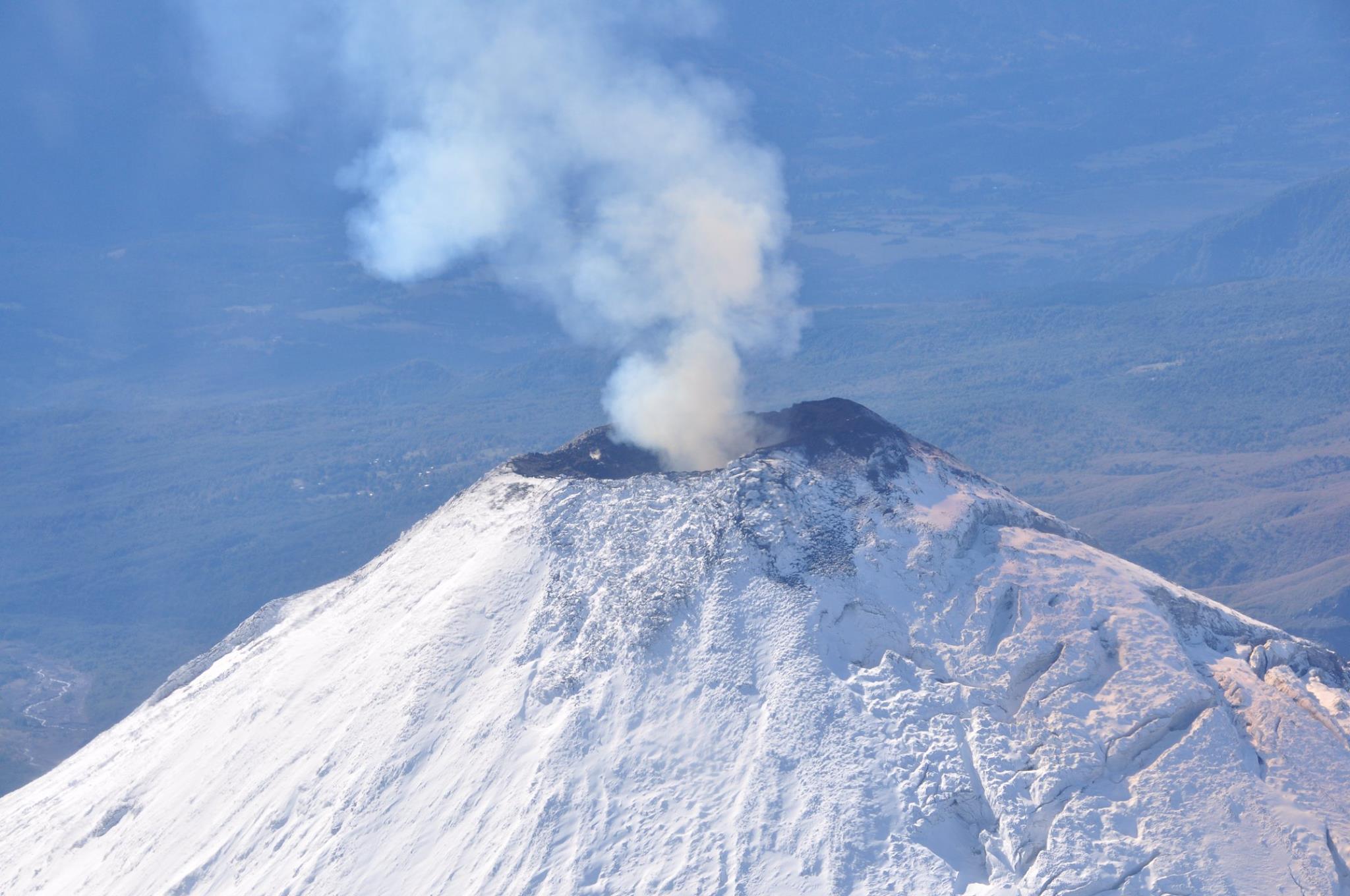
Indonesia , Dukono :
VOLCANO OBSERVATORY NOTICE FOR AVIATION – VONA .
Issued: July 19 ,2018.
Volcano: Dukono (268010)
Current Aviation Colour Code: ORANGE
Previous Aviation Colour Code: orange
Source: Dukono Volcano Observatory
Notice Number: 2018DUK137
Volcano Location: N 01 deg 41 min 35 sec E 127 deg 53 min 38 sec
Area: North Maluku, Indonesia
Summit Elevation: 3933 FT (1229 M)
Volcanic Activity Summary:
Eruption with volcanic ash cloud at 08h50 UTC (17h50 local).
Volcanic Cloud Height:
Best estimate of ash-cloud top is around 5533 FT (1729 M) above sea level, may be higher than what can be observed clearly. Source of height data: ground observer.
Other Volcanic Cloud Information:
Ash cloud moving to East.
Remarks:
Eruption and ash emission is continuing.
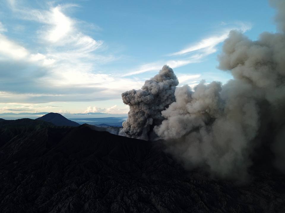
Level II Activity Level (WASPADA). The Dukono (1229 m above sea level) has a continuous eruption. Since yesterday until this morning visually the peak of the volcano can be observed clearly until it is covered with fog. The fumes / ashes emitted from the crater are white to gray, of low pressure and moderate intensity, rising up to 500 m above the summit. The wind is blowing weakly to the Northeast and East. Eruption observed up to 500 meters, color of the smoke: white and gray.
The seismographs dated July 21, 2018 recorded:
1 earthquake of eruption
3 distant tectonic earthquakes
Continuous tremor with a maximum amplitude of 0.5-4 mm (dominant of 2 mm)
Recommendations:
Communities around G. Dukono and visitors / tourists should avoid activities, climbing and approaching the Malupang Warirang Crater within a radius of 2 km.
Source : Magma Indonésie , PVMBG