June 16 , 2018.
Pu’u ‘Ō’ō / Kilauea , Hawai :
Thursday, June 14, 2018, 10:27 PM HST (Friday, June 15, 2018, 08:27 UTC)
19°25’16 » N 155°17’13 » W,
Summit Elevation 4091 ft (1247 m)
Current Volcano Alert Level: WARNING
Current Aviation Color Code: RED
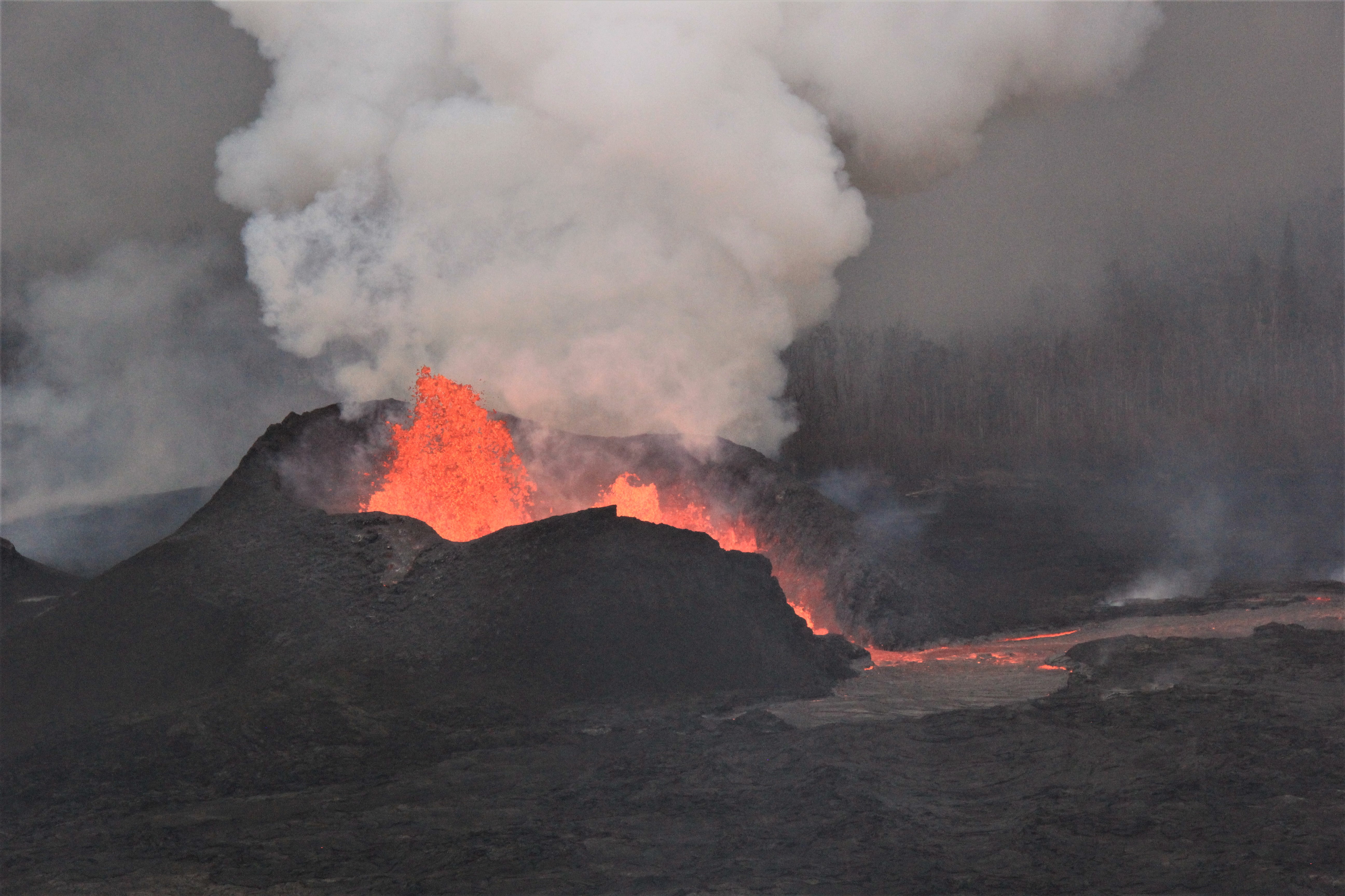
Kīlauea Volcano Lower East Rift Zone
The eruption of lava continues from the lower East Rift Zone (LERZ) in Leilani Estates with little change relative to the past few days.
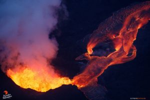
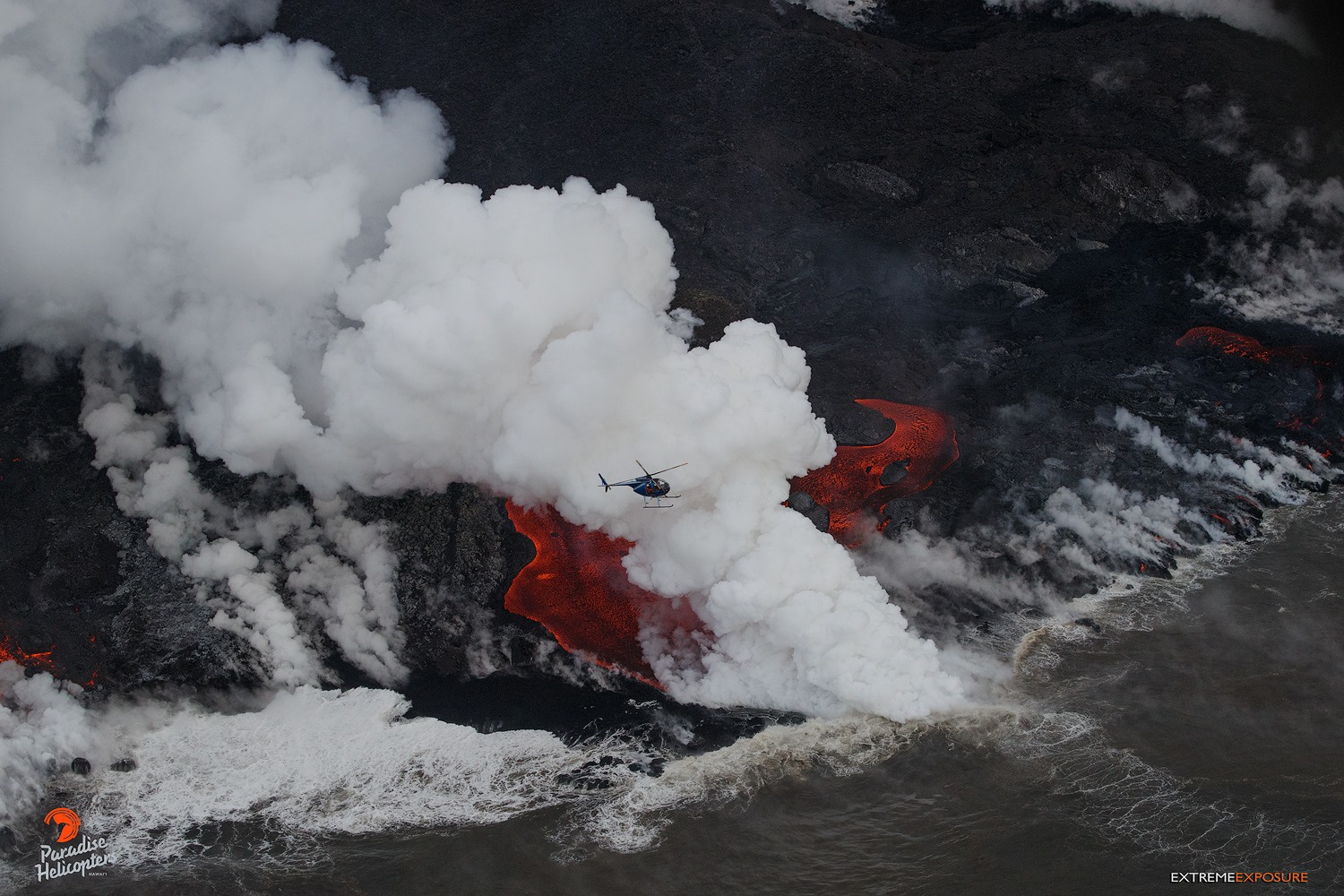
Fissure 8 lava fountains reached heights of 200 ft in the afternoon, and the cinder and spatter cone that is building around the fissure is now about 160 ft at its highest point. Lava is flowing through the well-established channel from fissure 8 to the ocean at Kapoho. Occasionally, lava spills over the channel levees. The ocean entry remained fairly broad with laze blown onshore. Fissures 16 and 18 continue to ooze lava.
Pele’s hair and other lightweight volcanic glass fragments from the lava fountain at Fissure 8 continue to fall downwind of the fissure, dusting the ground within a few hundred meters (yards) of the vent. High winds may waft lighter particles to greater distances. Residents are urged to minimize exposure to these volcanic particles, which can cause skin and eye irritation similar to volcanic ash.
HVO field crews are on site tracking the fountains, lava flows, and spattering from Fissure 8 as conditions allow and are reporting information to Hawaii County Civil Defense. Observations are also collected on a daily basis from cracks in the area of Highway 130; no changes in temperature, crack width, or gas emissions have been noted for several days.
Volcanic gas emissions remain very high from Fissure 8 eruptions. Wind conditions are changing and may bring VOG to the central, south, and western parts of the Island of Hawaii.
https://www.facebook.com/ann.kobsa/videos/10156413016209493/
Kīlauea Volcano Summit
After this morning’s small explosion at Kīlauea’s summit, seismicity levels immediately dropped but gradually increased over the course of the day climbing to about 30 events per hour by nightfall. Inward slumping of the rim and walls of Halema`uma`u continues in response to ongoing subsidence at the summit.
Sulfur dioxide emissions from the volcano’s summit have dropped to levels that are about half those measured prior to the onset of the current episode of eruptive activity. This gas and minor amounts of ash are being transported downwind, with small bursts of ash and gas accompanying intermittent explosive activity.

Friday, June 15, 2018, 9:03 AM HST (Friday, June 15, 2018, 19:03 UTC)
Kīlauea Volcano Lower East Rift Zone
The eruption of lava continues from the lower East Rift Zone (LERZ) in Leilani Estates with little change relative to the past few days.
Lava fountains from Fissure 8 reached heights of 200 ft overnight. The cinder and spatter cone that is building around the fissure is now about 165 ft at its highest point. Lava is flowing through the well-established channel from fissure 8 to the ocean at Kapoho. Occasionally, lava spills over the channel levees. The ocean entry remained fairly broad with laze blown onshore. Fissures 16 and 18 continue to ooze lava.
Kīlauea Volcano Summit
Seismicity increased overnight, climbing to about 40 events per hour with up to 5 magnitude-3+ earthquakes per hour. Many of these earthquakes were felt in the Volcano area. Inward slumping of the rim and walls of Halema`uma`u continues in response to ongoing subsidence at the summit.
Friday, June 15, 2018, 4:59 PM HST (Saturday, June 16, 2018, 02:59 UTC)
Kīlauea Volcano Lower East Rift Zone
The eruption of lava continues from the lower East Rift Zone (LERZ) in Leilani Estates with little change relative to the past few days.
Today, lava fountains from Fissure 8 reached heights between 100 and 130 ft with bursts up to 180 ft while the cinder and spatter cone that is building around the fissure is now about 170 ft at its highest point. Lava is flowing through the well-established channel from fissure 8 to the ocean at Kapoho. Occasionally, lava spills over the channel levees. The ocean entry remained fairly broad with laze blown onshore. Fissures 16 and 18 continue to ooze lava.
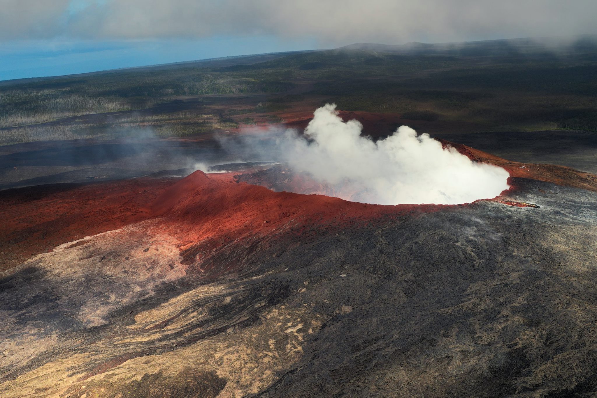
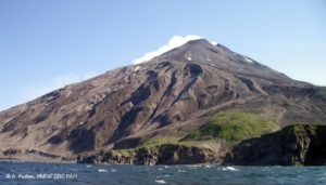
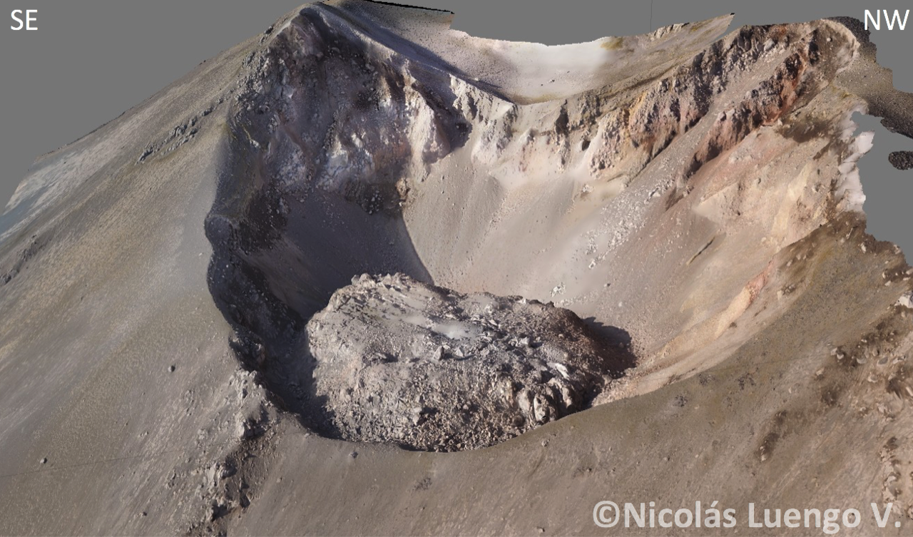
The crater of Pu’u ‘Ō’ō now.
Kīlauea Volcano Summit
Between 6 am and noon, more than 180 earthquakes occurred in the summit area, 18 of which were stronger than magnitude-3.0. An explosive event occurred at noon today that produced an ash and gas plume to nearly 10,000 ft. Seismicity dropped abruptly after the explosive event but is expected to build up slowly over the next hours. Inward slumping of the rim and walls of Halema`uma`u continues in response to ongoing subsidence at the summit.
Sulfur dioxide emissions from the volcano’s summit have dropped to levels that are about half those measured prior to the onset of the current episode of eruptive activity. This gas and minor amounts of ash are being transported downwind, with small bursts of ash and gas accompanying intermittent explosive activity.
Source : HVO
Video : Ann Kobsa
Photo : Bruce Omori , USGS , Harry Durgin .
Nevados de Chillan , Chile :
Volcanic Activity Report (RAV), Volcanological Observatory of the Southern Andes – Ovdas
June 14, 2018 16:00 HL June 14 (15:00 HL) 357070
Current alert level: ORANGE
Volcanic monitoring:
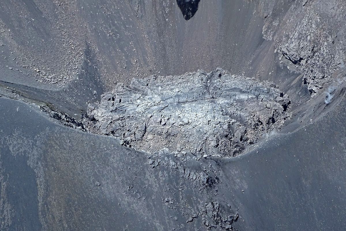
Observations: The most energetic VT event was located 1.5 km north-northwest of the active crater at a depth of 5.8 km.
Seismic activity: During the last 24 hours, the monitoring network of the Nevados volcanic complex in Chillan continues to record long-period seismicity (LP), and episodes of tremor, with seismic energy remaining at a rank considered as These two seismic events are related to the occurrence of explosions that drive the eruptive activity and the growth of a viscous lava dome in the Nicanor crater.
Observations
The meteorological conditions made it possible to visualize a column of mainly white colored gas and sometimes with greyish tones, which leave deposits of particles on the surface of the snow. The lava dome is visible from Portezuelo’s camera.
Other observations
⦁ Infrasound sensors recorded acoustic signals associated with explosions (EX) with maximum values and less than 0.3 Pa (reduced to 1 km as a reference).
⦁ No thermal radiation was reported according to the information processed by the MIROVA group.
⦁ The thermal camera installed at the Portezuelo station showed intermittent emissions highlighted by the incandescent recording.
Danger
Exposure / Specific risks:
These facts establish that, given current conditions, the most likely scenario is the generation of sporadic minor eruptive impulses (columns with an elevation not exceeding 5 km) associated with explosions of gas, particles and pyroclastic projections. ballistic whose range fluctuates around 2 or 3 km around the active crater. Similarly, it is likely that the lava dome may extend beyond the active crater, forming a viscous lava flowing towards the north-northeast. It will eventually be sensitive to gravity collapses, generating high-speed heat flows known as pyroclastic flows, with blocks and ashes, which could affect Gato and Las Minas, who in turn could trigger lahares. in the tributaries of the Nubian River.
In addition, it was considered with a lower probability, a moderate explosive eruptive phase (IEV = 3 to 4) associated with the partial or total destruction of the lava dome nestled in the active crater
Conclusion
The behavior of the Nevados de Chillan volcanic complex continues to evolve as a result of a minor eruption related to the location of a magmatic body that led to the slow growth of a lava dome nestled in the active crater « Nicanor » ( visible from the surveillance camera located north of the active crater), whose internal dynamics lead to an explosive activity of hot gases and pulsatile releases, ballistic particles around the crater, while maintaining the production of seismic events of the type long period and tremors, in ranges of energy considered moderate for this process. Calculated seismic energy has values with similar trends to those of previous weeks.
Source : Sernageomin.
Photo : Trailbyfire, Sernageomin , Nicolas Luengo.
Fuego , Guatemala :
Volcanological SPECIAL BULLETIN BEFGO # 75-2018, lahars in the ravines TANILUYÁ and CENIZA, Guatemala 15 June 2018, 17:40 (local time).
Type of activity: Vulcanienne
Morphology: Stratovolcan Composite
Location: 14 ° 28’54˝ Latitude N; 90 ° 52’54˝ Longitude W.
Altitude: 3,763msnm.
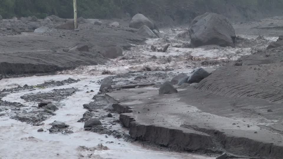
Due to continuous rains in the Fuego volcano region, the descent of lahars in the Taniluyá and Ceniza ravines is currently recorded. Their dimensions are about 20 to 25 meters wide and 2 meters high, which causes vibrations on their way.
The materials of these lahars are very fine, with pasty matter, blocks up to 3 meters in diameter. They slide trunks and branches of trees along their path, and because of the last eruption, they descend hot, feeling the smell of sulfur and giving off steam because of their temperature.
Due to rains that occur in the afternoon and evening, the probability of lahars occurring in one of the main ravines persists.
Source : Insivumeh
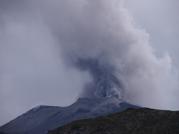
Klyuchevskoy , Kamchatka :
VOLCANO OBSERVATORY NOTICE FOR AVIATION (VONA).
Issued: June 15 , 2018.
Volcano:Klyuchevskoy (CAVW #300260)
Current aviation colour code:ORANGE
Previous aviation colour code:orange
Source:KVERT
Notice Number:2018-51
Volcano Location:N 56 deg 3 min E 160 deg 38 min
Area:Kamchatka, Russia
Summit Elevation:15580 ft (4750 m)
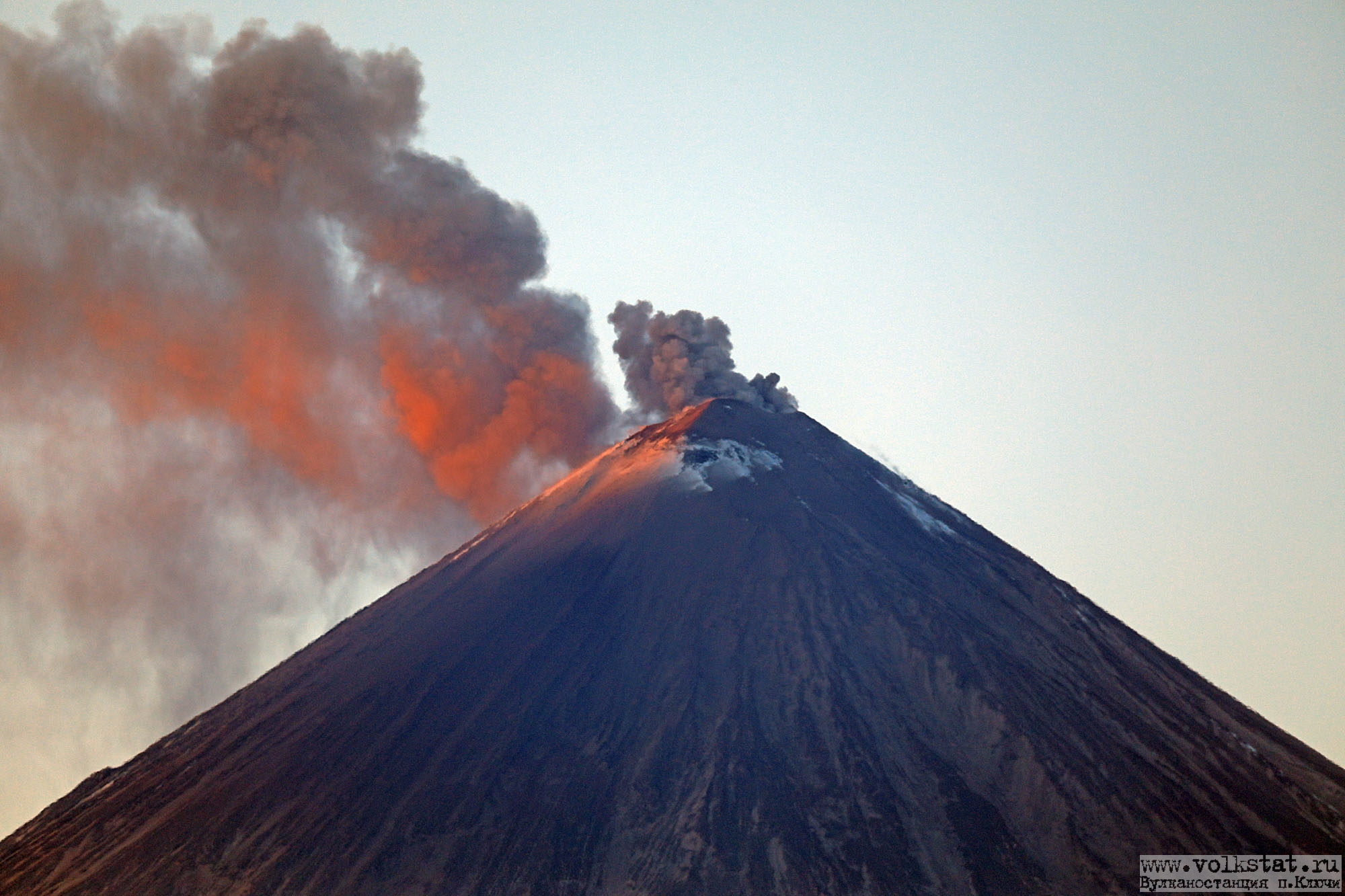
Volcanic Activity Summary:
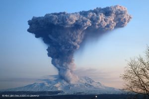
A single moderate explosion sent ash up to 6 km a.s.l. from 2138 UTC, ash plume drift to the south-western direction from the volcano.
A moderate activity of the volcano continues. Ash explosions up to 26,240 ft (8 km) a.s.l. could occur at any time. Ongoing activity could affect international and low-flying aircrafts.
Volcanic cloud height:
19680 ft (6000 m) AMSL Time and method of ash plume/cloud height determination: 20180615/2156Z – Video data
Other volcanic cloud information:
Distance of ash plume/cloud of the volcano: 3 mi (5 km)
Direction of drift of ash plume/cloud of the volcano: SW
Time and method of ash plume/cloud determination: 20180615/2138Z – Video data
Start time of explosion and how determined: /2138Z – unknown
Source : Kvert.
Photo : Yu. Demyanchuck , Volkstat ru.