April 27 , 2018.
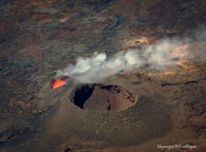
Ioyama , Japan :
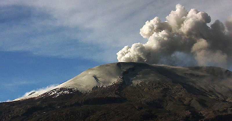
Mount Ioyama in Kyushu erupts for second time in a week, after stirring from 250-year dormancy.
Apr 26, 2018
MIYAZAKI – The volcano in southwestern Japan erupted again on Thursday, a week after it spewed a plume of ash for the first time in 250 years.
The scale of the eruption was very small, the Japan Meteorological Agency said.
Last Friday the agency said that eruptions had stopped at Mount Io, one of the Mount Kirishima group of volcanoes straddling Miyazaki and Kagoshima prefectures. They had begun the previous day.
The latest eruption occurred at around 6:15 p.m., with smoke from the crater reaching heights of more than 200 meters above the ground, the agency said.
As of Thursday the agency maintained an eruption warning of Level 3, which bans climbing on the mountain.
The agency urged caution regarding possible pyroclastic flow or rocks being ejected from the crater, which could reach areas up to about 2 kilometers from the volcanic vent.
Source : Japantimes.
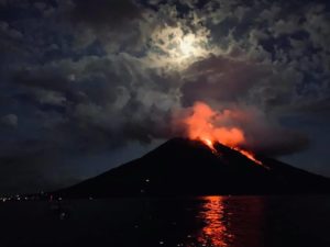
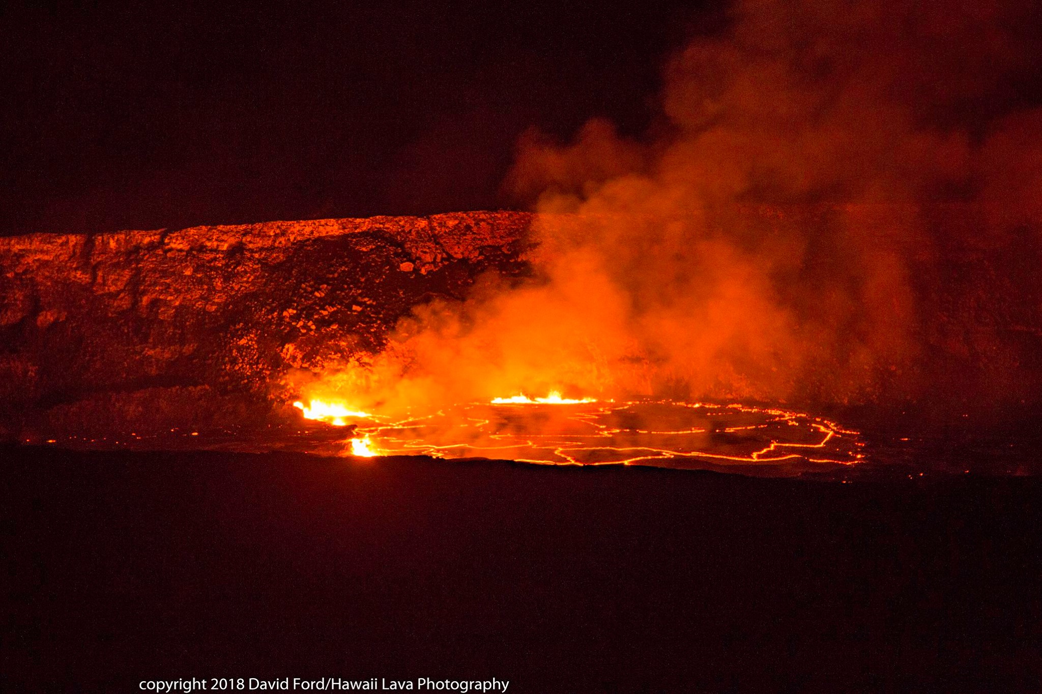
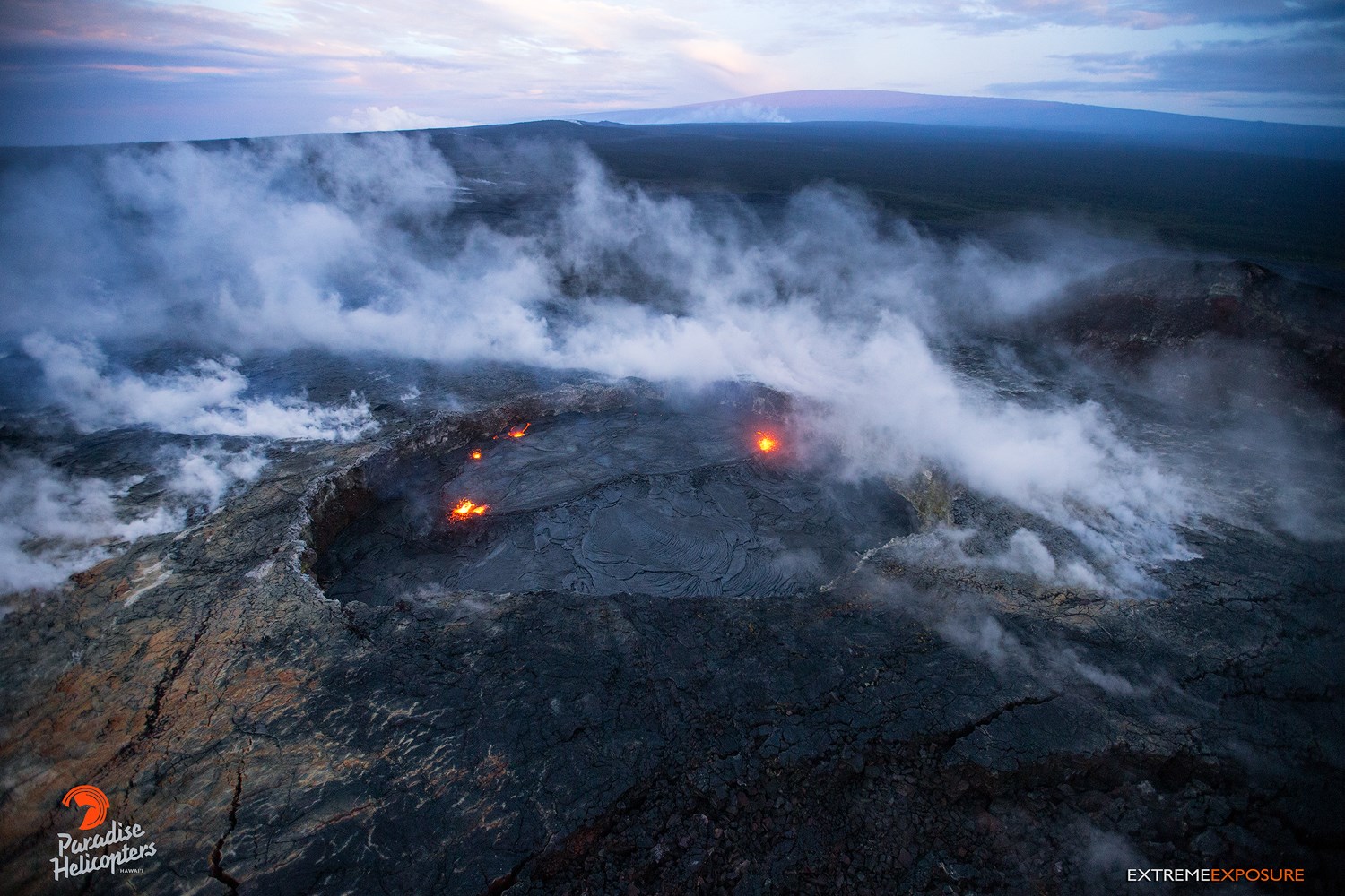
Kilauea , Hawai :
19°25’16 » N 155°17’13 » W,
Summit Elevation 4091 ft (1247 m)
Current Volcano Alert Level: WATCH
Current Aviation Color Code: ORANGE
Activity Summary:
Eruptions continue at Kīlauea Volcano’s summit and East Rift Zone. The summit lava lake has continued to overflow the Overlook crater rim in several pulses overnight and into this morning. Overall, summit tiltmeters continue to record an inflationary signal with brief periods of deflation. Tiltmeters and GPS at Puʻu ʻŌʻō cone continue the overall inflationary trend of the past several weeks, and the Episode 61g lava flow remains active within two kilometers (~1.2 miles) of the vent. The flow does not pose a threat to nearby communities at this time. There is currently no active lava on the pali, the coastal plain, or entering the ocean.
Summit Observations:
The lava lake spilled over the Overlook crater rim onto the floor of Halema’uma’u in several pulses overnight. Active overflow continues this morning. As of 8:00 am, HVO estimates that only about 1/4 of the Halema’uma’u floor remains uncovered by new overflows. Summit tiltmeters continue to record an overall inflationary trend with brief periods of deflation overnight. Seismicity in the summit area has not changed significantly. Tremor amplitude is fluctuating with lava lake spattering and seismometers have recorded a few small earthquakes in the upper East Rift Zone and south part of the caldera. Elevated summit sulfur dioxide emission rates persist.

Puʻu ʻŌʻō Observations:
Inflationary tilt continues to be recorded by a tiltmeter at Puʻu ʻŌʻō. Webcam views are limited by weather this morning but overnight showed no new flows in the crater. Seismicity has not changed significantly. The sulfur dioxide emission rate from the East Rift Zone vents has been steady over the past several months and remains significantly lower than the summit emission rate.
Lava Flow Observations:
There is no lava flow activity from the Episode 61g lava flow on the coastal plain or pali, and no lava is flowing into the ocean. Lava flow activity continues on the upper flow field, above the pali and closer to Puʻu ʻŌʻō, and does not pose a threat to nearby communities at this time. Areas of the upper flow field with active lava flows are located within the Kahaualeʻa Natural Area Reserve, which has been closed to the public by DLNR since 2007 due to volcanic hazards.
Source : HVO
Photos : David Ford , Bruce Omori.
Guallatiri , Chile :
Special Report on Volcanic Activity (REAV)
Region of Arica and Parinacota, Guallatiri volcano, April 26, 2018, 19:17 Local (mainland Chile)
69.2 ° W 69.1 ° W 69 ° W
The National Geological and Mining Service of Chile (SERNAGEOMIN) describes the following preliminary information obtained by the monitoring teams of the National Volcanoes Surveillance Network (RNVV), processed and analyzed by the Volcanological Observatory of the South Andes (OVDAS):
On April 26 at 16:00 local time (19:00 GMT) the monitoring stations installed in the vicinity of the Guallatiri volcano recorded an earthquake associated with rock fracturing (volcano-tectonic type), located 7 km south-southwest of the main crater.
The characteristics of the earthquake are as follows:
Original time: 16:00 local time (19:00 GMT)
Latitude: 18.483 ° S
Longitude: 69.106 ° C
Depth: 8.0 km
LOCAL MAGNITUDE: 3.9 (ML)
OBSERVATIONS:
When this report was issued, there were three (3) replicas at a similar location and smaller amplitude (ML <1).
The volcanic technical alert remains at the level: GREEN.
Source : Sernageomin.
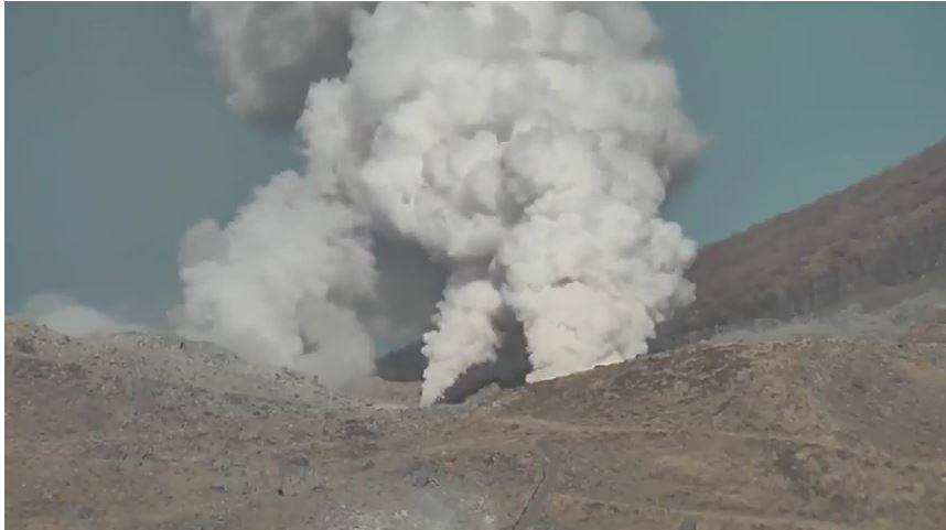
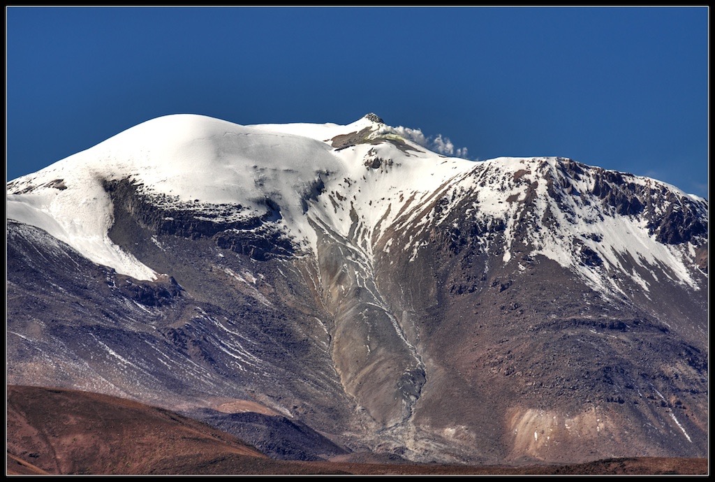
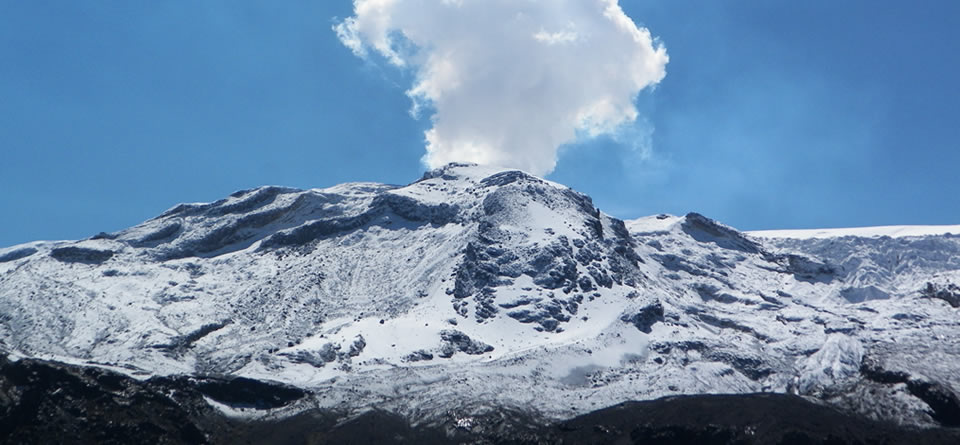
Nevado del Ruiz , Colombia :
Subject: Bulletin of activity of the Nevado del Ruiz volcano.
The level of activity continues at the level: Yellow activity level or (III): changes in the behavior of volcanic activity.
With regard to monitoring the activity of the Nevado del Ruiz volcano, the COLOMBIAN GEOLOGICAL SERVICE informs that:
The seismicity caused by the fracturing of the rocks that make up the volcano, showed similar levels in the number of events and in the released seismic energy, compared with the previous week. This seismicity was mainly northeast and southeast of the volcanic structure and, to a lesser extent, on the southwest and northwest flanks of the volcano, at depths between 1.8 and 7.1. km. The maximum magnitude recorded during the week was 0.7 ML (Local Magnitude) corresponding to an earthquake recorded on April 17, located near the crater Arenas, at a depth of 2.0 km.
The seismic activity associated with the dynamics of the fluids within the channels of the volcanic structure showed an increase in the number of registered earthquakes and released seismic energy, compared to the previous week. This type of activity is mainly characterized by the occurrence of multiple fluidic earthquakes, long periods and very long periods, as well as pulses of tremors. This highlights the recording of an episode of continuous volcanic tremor, of low energy level. The earthquakes were mainly located in the crater of Arenas and its surroundings.
Volcanic deformation measured from electronic inclinometers, Global Navigation Satellite System (GNSS) stations and radar images shows stability behavior without recording significant deformation processes of the volcanic structure.
The volcano continues to emit water vapor and gases into the atmosphere, among which the sulfur dioxide (SO2) is distinguished, as evidenced by the values obtained by the SCANDOAS stations installed on the volcano and the analysis satellite images. In tracking the information provided by the MIROVA and NASA FIRMS portals, no thermal anomalies were recorded.
The column of gas and steam reached a maximum height of 1100 m measured at the top of the volcano, April 22. The direction of the dispersion of the column was governed by the direction of the wind in the area, which during the week prevailed to the northwest relative to the crater Arenas.
The Nevado del Ruiz volcano continues at the level of activity : yellow .
Source : Ingeominas.