April 09 , 2018.
Kilauea , Hawaï :
19 ° 25’16 « N 155 ° 17’13 » W,
Sommet : 4091 pi (1247 m)
Niveau d’alerte volcanique actuel: ATTENTION
Code couleur actuel de l’aviation: ORANGE
Activity Summary:
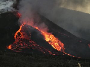
Eruptions at Kīlauea Volcano’s summit and East Rift Zone continue. The summit lava lake rose slightly over the past day, with spattering visible from Jaggar Museum this morning. Puʻu ʻŌʻō cone has been inflating with recent lava flows on the crater floor. The Episode 61g lava flow is active above Pulama pali and does not pose a threat to nearby communities at this time. There is currently no active lava on the pali, the coastal plain, or entering the ocean. Low rates of ground deformation and seismicity continue across the volcano.
Today April 06 , at 10:28 a.m. HST, a partial collapse of the southern Overlook crater wall triggered an explosive event at Kīlauea Volcano’s summit lava lake. A large plume of gas, ash, and lava fragments was seen rising from the lava lake at the Jaggar overlook. The explosion threw debris onto the Halema‘uma‘u crater rim at the old visitor overlook, which has been closed due to ongoing volcanic hazards such as this explosive event.
Summit Observations:
Yesterday at about noon the lake level was measured at 29 m (95 ft) below the floor of Halema`uma`u crater, and the lake rose slightly over the past day. Spattering is visible from HVO and Jaggar Museum this morning. Summit tiltmeters recorded continued inflationary tilt over the past day. The seismicity in the summit area is within normal, background rates, with tremor amplitude fluctuations associated with lava lake spattering. Elevated summit sulfur dioxide emission rates persist.
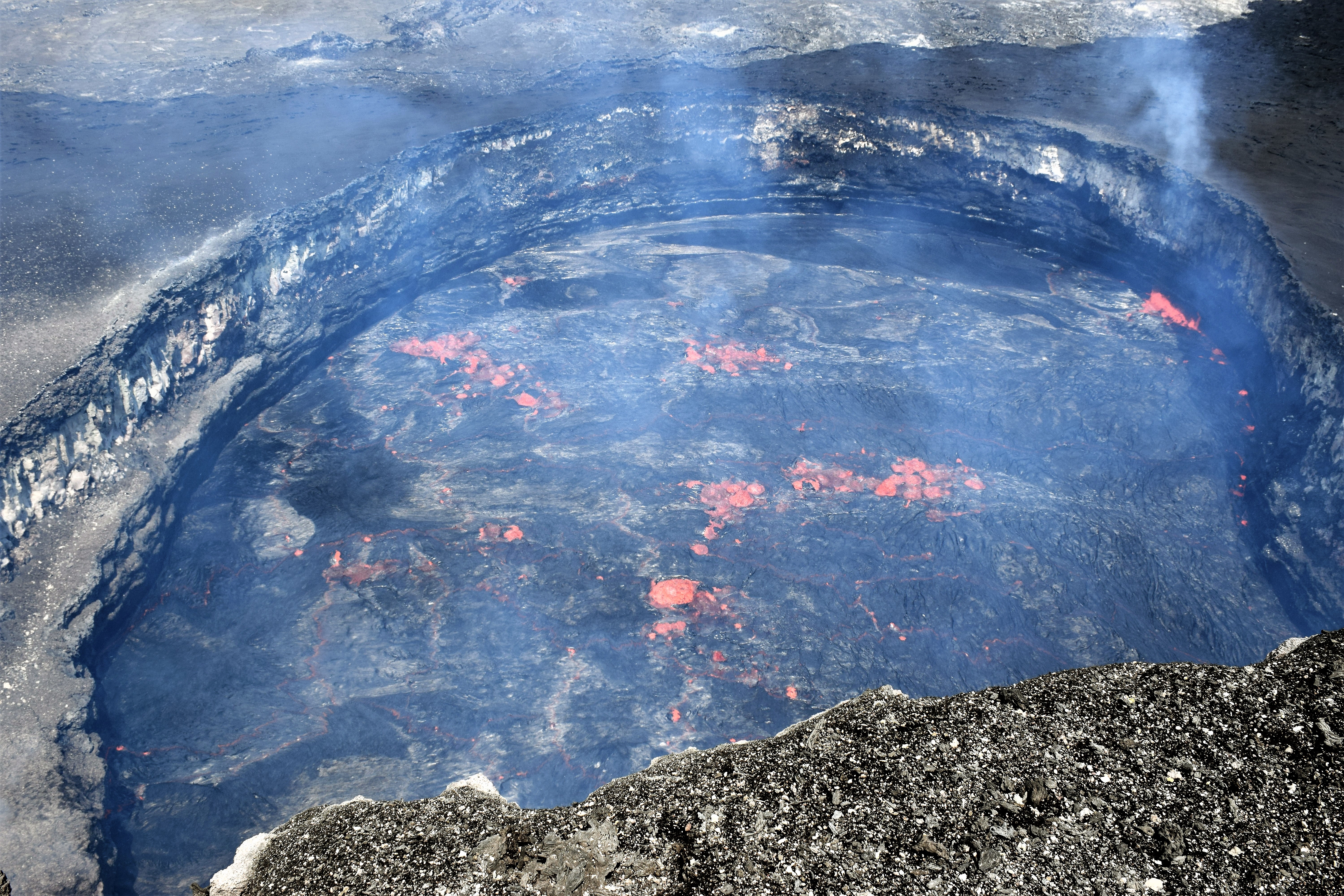
Geologists arrived at Halema‘uma‘u about 40 minutes after the explosive event to document the deposit and check on the webcams and other monitoring equipment. Upon arrival, the surface of the lava lake was still disturbed from the rock falls impact.
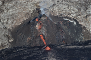
Puʻu ʻŌʻō Observations:
Puʻu ʻŌʻō tiltmeters showed no significant change over the past day, but overall inflation has occurred over the past several weeks. No lava flow activity was observed on the crater floor this morning. Webcam views of spattering from the West Pit lava pond also continue. The sulfur dioxide emission rate from the East Rift Zone vents has been steady over the past several months and remains significantly lower than the summit emission rate.
Lava Flow Observations:
Recent overflight observations confirm that there is no lava flow activity from the Episode 61g lava flow on the coastal plain and pali. No lava is flowing into the ocean. Lava flow activity on the upper flow field, closer to Puʻu ʻŌʻō, continues and does not pose a threat to nearby communities at this time.
Source : HVO
Nevados de Chillan , Chile :
Volcanic Activity Report (VAR), Volcanological Observatory of the Southern Andes – Ovdas
Date: April 8, 2018 4:30 pm HL on April 8 (3:00 pm)
Current alert level: ORANGE
1. Volcanic monitoring
1.1 Seismic activity:
The activity of the volcanic complex Nevados de Chillan, in the last 24 hours, has a level of activity similar to that of previous days, with the recording of explosions correlated by the recordings of IP cameras. The occurrence of LP seismicity and a tremor has a moderate value. The VT type earthquakes continue with a marked absence more characteristic in the eruptive development of the complex.
1.2 Surface activity
Maximum height of the column (km) 0.100.
Direction: East
Main distance Panache (km): not detected.
Source of information: OVDAS IP camera
Incandescence (yes / no): Yes
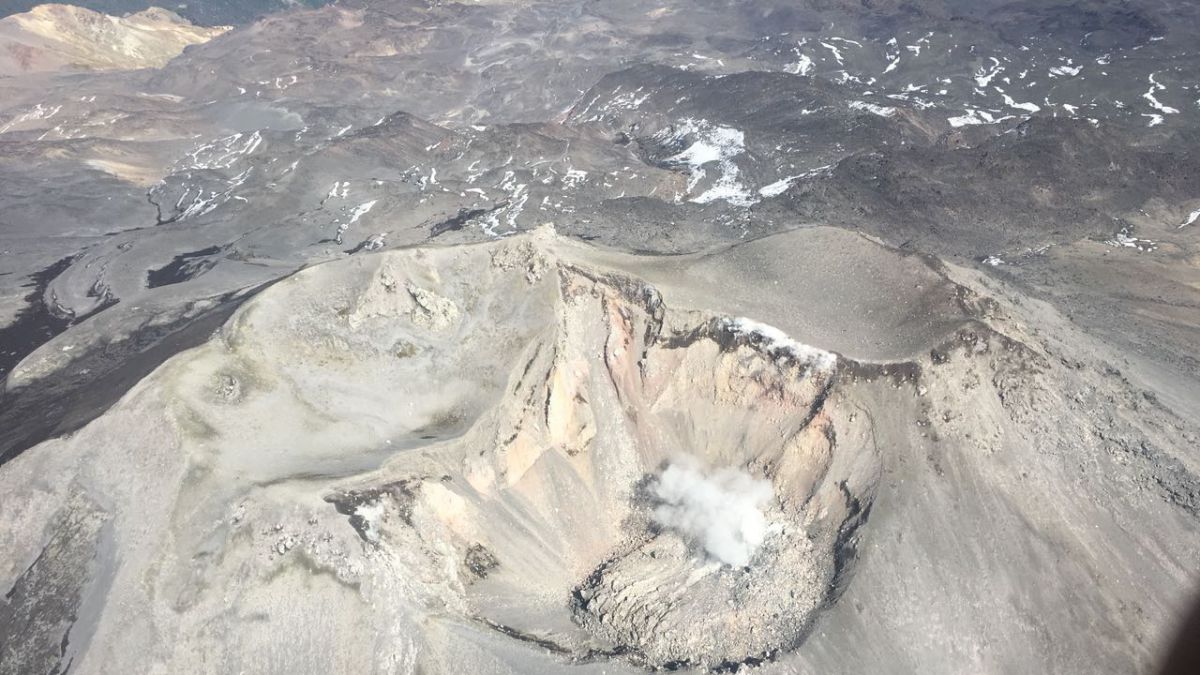
Observations:
The gas columns observed by the IP cameras were weak and quickly dissipated by the current wind regime, showing low heights and mainly whitish colors.
1.3 Other observations
⦁ Due to the low energy in the development of the explosions, the infrasonic sensors did not highlight the signals of this type coming from the Volcanic Complex.
⦁ Information on thermal radiance processed by the MIROVA group and reported on its website did not detect anomalies.
2. Danger
The area of potential danger is determined on the basis of a moderate to high explosive eruptive phase, associated with a partial destruction of the lava dome nestled in the active crater. The procedure planned before this event would be the generation of a 10-kilometer high eruptive column that collapses, which could generate pyroclastic surges that would radially affect the crater.
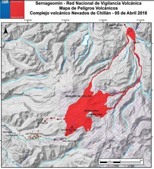
Eventually, depending on the availability of sediments and water, flooding could occur in the large valleys draining the Las Termas sub-complex, mainly towards Estero Renegado, Shangri-La Valley, the Rio’s headwaters. Nuble. In addition, the gravitational collapse of the lava dome of the Northeast crater is envisaged, which could affect the Gato and Las Minas rivers through pyroclastic flows, ash and blocks.
Finally, the most likely scenario is the sporadic generation of minor eruptive impulses (columns no greater than 5 km altitude) associated with explosions of gas, pyroclastic particles whose ballistic projections fluctuate over a distance of 2 to 3 km around the active crater.
Source : Sernageomin.
Popocatepetl , Mexico:
April 8, 11:00 am (April 8, 16:00 GMT)
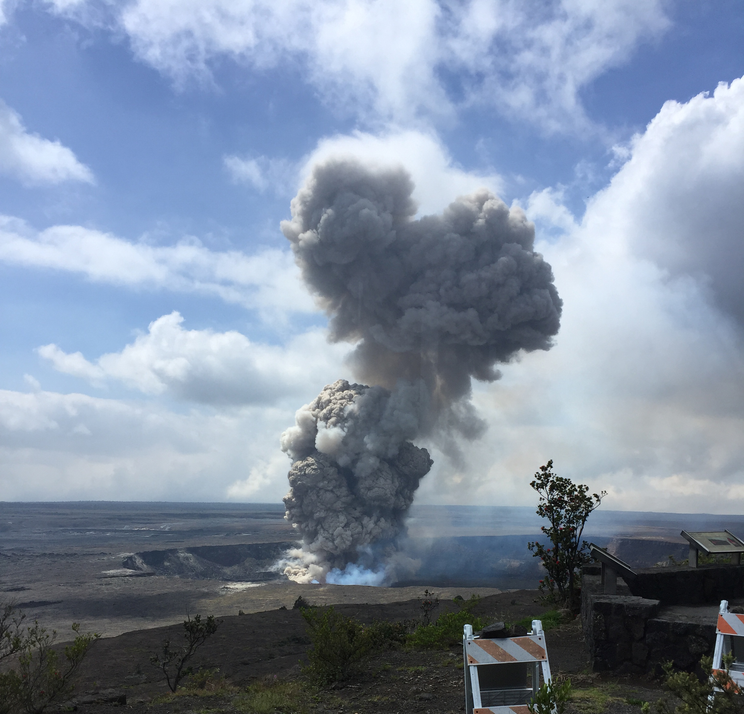
In the last 24 hours, through the monitoring systems of the Popocatépetl volcano, 27 low intensity exhalations have been identified. Despite the presence of cloudiness throughout yesterday, and part of the morning today, a constant fumarole of water vapor and gas was observed. In addition, five volcano-tectonic earthquakes were recorded, with preliminary amplitudes of M2.5 (two of them), M2.4, M2.3 and M2.0.
At the time of this report, there is partial visibility towards the volcano due to clouds. In the previous hours, it was possible to see an emission of water vapor and gas that the winds broadcast to the southwest.
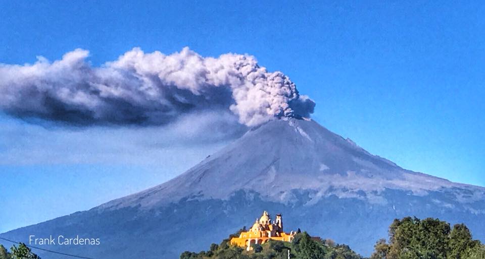
Updated April 8, 4:40 pm (April 8, 9:40 pm GMT)
From 13:11 h, it was noted the increase in the recording of low intensity exhalations accompanied by steam, gas and sometimes small amounts of ash. The height of the column is less than 1000 m. Due to the cloud conditions in the area, it has not been possible to observe the volcano permanently, but for short periods, it has been confirmed that the emissions are dispersed by the wind to the northwest . At the time of this update, the seismic activity returns to the previous levels. This type of activity is considered in the Phase 2 scenarios of the Yellow Volcanic Warning Semaphore. Any changes will be reported in a timely manner
CENAPRED asked not to approach the volcano and in particular the crater, because of the risk of falling of projectiles, and in case of heavy rain to remain far from the bottom of the ravines because of the danger of landslides and flows of mud.
The volcanic warning light of the Popocatepetl volcano is located at Amarillo Phase 2.
Source : Cenapred
Photo : F Cardenas.
San Miguel ( Chaparrastique ) El Salvador :
Special Report No 8
The activity of the Chaparrastic volcano tends to decrease
Date and time of publication: 03 April 2018-, 13:25:00
The activity of the Chaparrastic volcano has shown a tendency to decrease. During the last 24 hours, seismic vibration has varied between 46 and 87 RSAM units, with an average of 55 units (Figure 1), the normal value is between 50 and 150 RSAM units on average.
At 10:12, on this day of April 3, the volcano is partially covered with meteorological cloud, masking the degassing.
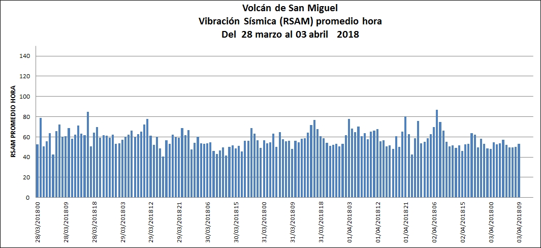
Correlation of Sulfur Dioxide Flow and Seismic Vibrations in RSAMs. Data analysis indicates that both parameters fluctuate within an acceptable threshold with a downward trend over the past few days (Figure 1 ).
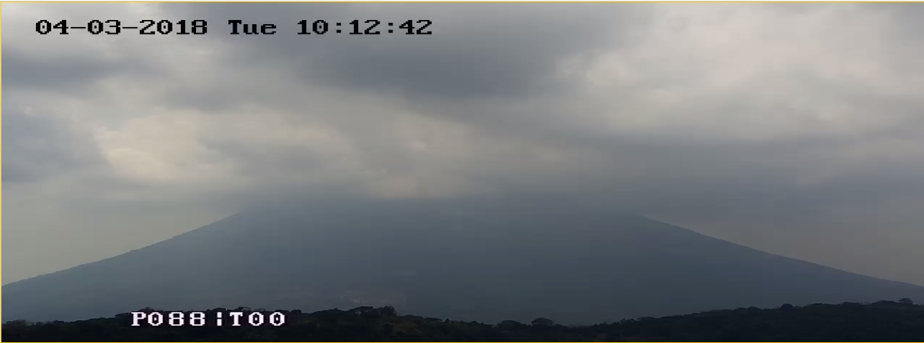
Figure 2. Current situation of Chaparrastic volcano at 10:12. (04.03.2018)
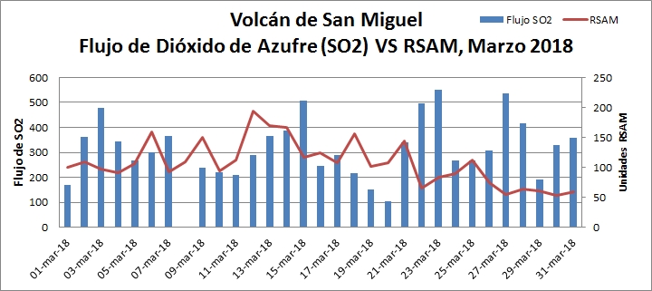
Figure 3. Flow of sulfur dioxide relative to RSAM.
According to the monitoring, the activity of the volcano showed a downward trend, being compatible with the decrease of the seismic vibration and the emission of gas. However, periodic changes in seismicity and degassing suggest the presence of fluids in the system, so it is not excluded that in the future there will be changes.
MARN continues the systematic monitoring of the volcano and maintains close communication with the Directorate General of Civil Protection and local observers. In addition, he calls tourists and mountaineers to stay away from the upper part of the volcano because often there are sudden changes in activity.
Source : Snet .