January 28 , 2024.
Alaska , Great Sitkin :
Eruption of lava within the summit crater of Great Sitkin Volcano continues. Over the past week, satellite imagery showed that the eruption of new lava has been restricted to the center of the active summit lava dome, with little advancement of its outer margins. The center of the lava flow continues to uplift with expansion of radial cracks, and a new lobe of lava has extruded from the northernmost crack and reached about 180 m (590 ft) to the northwest of the vent in January 24 satellite radar imagery. Weakly elevated surface temperatures were observed when satellite views were partly cloudy.
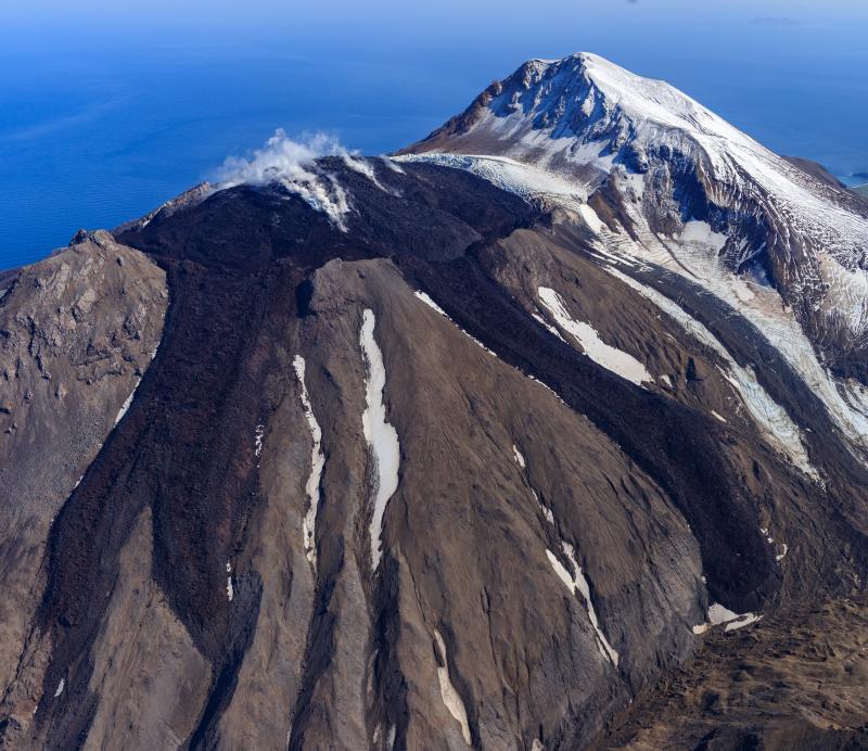
Local monitoring data have been off-line since January 2 due to a storm-related power failure.
The current prolonged period of lava eruption at Great Sitkin Volcano began in July 2021. No explosive events have occurred since a single event in May 2021.
The volcano is monitored by local seismic, geodetic, and infrasound sensors and web cameras (when operational), regional infrasound and lightning networks, and satellite data.
Source : AVO
Photo : Loewen, Matt / Alaska Volcano Observatory / U.S. Geological Survey
Alaska , Edgecumbe :
January 26, 2024, 8:44 am
Following the initial installation of a single temporary seismic and geodetic station on Kruzof Island in May 2022, the Alaska Volcano Observatory (AVO) installed an expanded, permanent local monitoring network at Edgecumbe in July 2023. The network consists of 4 seismic stations and 4 global navigation satellite system (GNSS) sites measuring ground deformation on Kruzof Island. There is also an additional seismic station in Sitka, 24 km (15 miles) to the east of the volcano that is operated by the National Tsunami Warning Center. This network expansion has improved our ability to observe volcanic activity and accurately locate earthquakes and measure ground deformation. After an evaluation period following the 2023 field season, AVO now considers the new network sufficiently reliable to confidently monitor seismic unrest at Edgecumbe, AVO’s main criterion to set an Alert Level and Color Code status. With the establishment of robust monitoring data, Edgecumbe is being moved from UNASSIGNED to Volcano Alert Level NORMAL and Aviation Color Code GREEN.
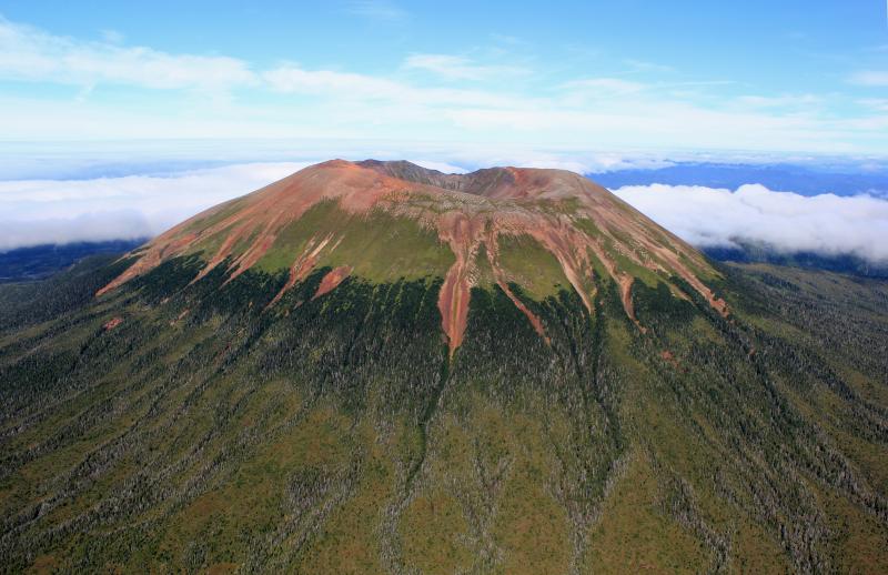
Aerial photo of Mt. Edgecumbe (L’úx Shaa) taken during a helicopter overflight during the summer 2023 geophysical network installation.
Update on long-term low-level activity at Mount Edgecumbe
Low-level unrest at Mount Edgecumbe continues and is consistent with magma intrusion at deep levels in the Earth’s crust (greater than six miles below sea level).
The rate of ground uplift has declined to about 2–3 cm/year (0.8–1.2 inches/year).
Low numbers of primarily small earthquakes continue, and AVO is now able to detect and locate earthquakes smaller than magnitude 1 with the new network.
No anomalous volcanic gases have been detected.
Additional signs of volcanic unrest would likely occur prior to an eruption as magma rises to the surface. Some magma intrusions do not erupt.
Edgecumbe is monitored by local seismic and GNSS sensors, satellite data, a web camera, and remote infrasound and lightning networks.
Source : AVO
Photo : Grapenthin, Ronni / Alaska Volcano Observatory / University of Alaska Fairbanks, Geophysical Institute.
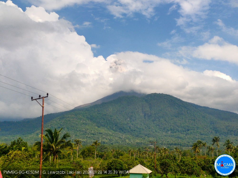
Indonesia , Lewotobi Laki Laki :
An eruption of Mount Lewotobi Laki occurred on Sunday, January 28, 2024 at 2:37 p.m. WITA with the height of the ash column observed at ±500 m above the summit (±2084 m above sea level). The ash column was white to gray in color with moderate to thick intensity, oriented towards the North and Northeast. At the time of writing, the eruption was still ongoing.
SEISMICITY OBSERVATIONS
2 eruption/explosion earthquakes with an amplitude of 47.3 mm and a seismic duration of 43 to 227 seconds.
18 avalanche earthquakes with an amplitude of 8.8 to 47.3 mm and an earthquake duration of 31 to 123 seconds.
3 emission earthquakes with an amplitude of 8.8 to 37 mm and duration of the earthquake from 19 to 37 seconds.
1 Low frequency earthquake with an amplitude of 14.8 mm and an earthquake duration of 37 seconds.
1 hybrid/multiphase earthquake with an amplitude of 25.9 mm, and an earthquake duration of 15 seconds.
RECOMMENDATION
1. Communities around Mount Lewotobi Laki and visitors/tourists do not carry out any activities within a radius of 5 km from the center of the Mount Lewotobi Laki eruption and in an area located 6 km to the North-East.
2. The public should remain calm and follow the instructions of the regional government and not believe rumors whose origin is unclear.
3. Communities around Mount Lewotobi Laki are wary of the risk of lahar flooding in the rivers that originate at the summit of Mount Lewotobi Laki during heavy rains.
Source et photo : Magma Indonésie.
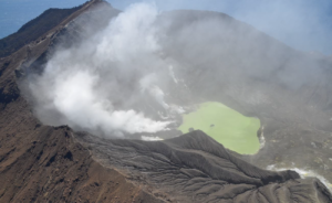
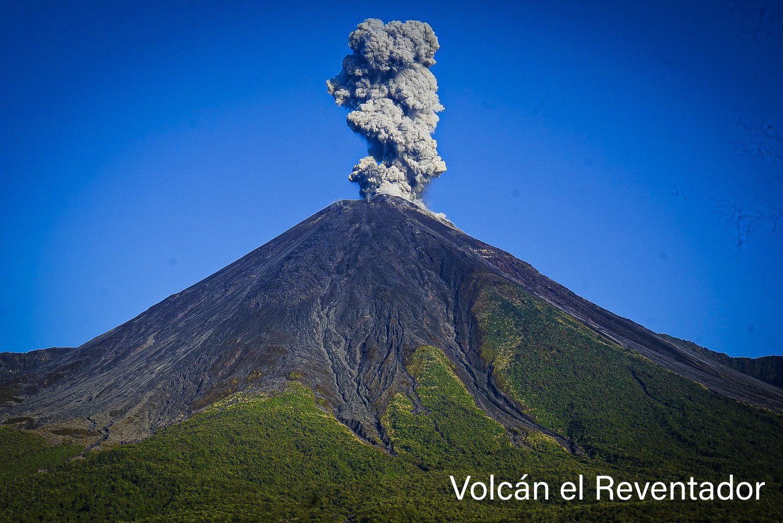
Ecuador , Reventador :
DAILY REPORT ON THE STATE OF THE REVENTADOR VOLCANO, Saturday January 27, 2024.
Information Geophysical Institute – EPN.
Surface activity level: Moderate, Surface trend: No changes
Internal activity level: Moderate, Internal trend: No changes
Seismicity: From January 26, 2024, 11:00 a.m. to January 27, 2024, 11:00 a.m.:
The following table shows the number of seismic events from the reference station over the last 24 hours.
Explosion (EXP) 31
Long Period (LP) 7
Transmitting tremor (TREMI) 12
Precipitation/Lahars:
Rainfall is not recorded. **In the event of heavy rains, these could remobilize the accumulated materials, generating mud and debris flows which would descend the sides of the volcano and flow into adjacent rivers.
Emissions/ash column:
From yesterday afternoon until today morning, thanks to the surveillance camera system, several gas and ash emissions were recorded with heights of 300 to more than 1000 meters above the level of the crater, oriented to the North, West, North-West and West-North-West. On the other hand, the VAAC in Washington published two reports reporting ash emissions at a height of 1,100 meters above the level of the crater, in the northwest direction.
Other monitoring parameters:
The MIROVA-VIIRS satellite system recorded 3 thermal anomalies and the FIRMS system recorded 6 thermal anomalies, over the last 24 hours.
Observation:
Yesterday evening the volcano remained generally clear, allowing us to observe an episode of expulsion of incandescent material up to 200 meters above the level of the crater. At the end of this report, the volcano remained cloudy.
Alert level: Orange.
Source : IGEPN.
Photo : Hosteria el Reventador
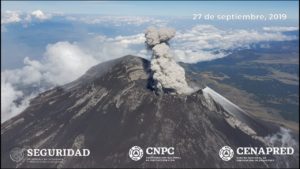
Mexico , Popocatepetl :
January 27, 11:00 a.m. (January 26, 5:00 p.m. GMT)
Activity from the last 24 hours
26 exhalations were detected, in addition 913 minutes of high frequency, low amplitude tremors were identified; Both volcanic events were accompanied by water vapor, other gases and ash.
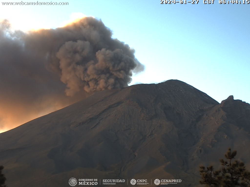
At 09:57 h, an exhalation was recorded which created a column of ash estimated at 2400 m above the crater, which dispersed towards the East-North-East (ENE).
It should be noted that in the last 24 hours only a slight fall of ash was reported yesterday at 11:40 a.m. in the municipalities of Natívitas, San Pablo del Monte, Ixtacuixtla de Mariano Matamoros, Zacatelco, Chiautempan, Santa Ana Nopalucan, Tlaxcala , Totolac and Panotla in the state of Tlaxcala.
During the morning and at the time of this report, a continuous emission of water vapor, volcanic gases and ash is observed, with dispersion towards the East-North-East (ENE).
The Popocatépetl volcanic warning fire is in yellow phase 2.
Source : Cenapred.