December 10 , 2025.
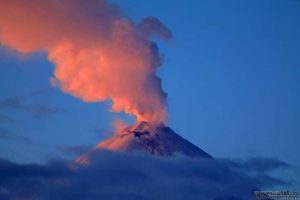
Italy , Stromboli :
WEEKLY BULLETIN, December 1, 2025 to December 7, 2025 (publication date: December 9, 2025)
ACTIVITY SUMMARY
Based on monitoring data, the following points should be noted:
1) VOLCANOLOGICAL OBSERVATIONS: During this period, ordinary Strombolian-type eruptive activity was observed, with ejections originating from the North Crater area. The total hourly frequency varied between average (15 events/hour) and high (24 events/hour). The intensity of the explosions was mostly low to medium in the North and Central-South Crater areas.
2) SEISMOLOGY: The monitored seismic parameters showed no significant variations.
3) GROUND DEFORMATION: The ground deformation monitoring networks did not show any significant variations during the past week.
4) GEOCHEMISTRY: Average SO₂ flux
High CO₂ flux from the ground in the Pizzo area (STR02) (approximately 11,000 g/m²/day)
C/S ratio in the pen: The C/S ratio is average
Dissolved helium isotope ratio (R/Ra) in the thermal aquifer: No updated data are available. The latest available data (November 5, 2025) indicates very high values.
CO₂ flux from the ground in the San Bartolo area: Very high.
CO₂ flux from the ground in the Scari area: Stable at approximately 130 g/m²/day
5) SATELLITE OBSERVATIONS: Satellite-observed thermal activity in the summit area was generally low, with a few isolated thermal anomalies of moderate intensity.
VOLCANOLOGICAL OBSERVATIONS
During the observation period, Stromboli’s eruptive activity was characterized by analyzing images recorded by the INGV-OE monitoring cameras located at 190 m (SCT-SCV) and at Punta dei Corvi (SPCT). Explosive activity was primarily produced by five eruptive vents located in the northern crater area and by at least two vents located in the central-southern area.
Due to heavy cloud cover on December 4, the crater terrace was not visible for a sufficient number of hours for a precise description of the eruptive activity.
Observations of explosive activity captured by the monitoring cameras:
Five active winds were observed in the northern (N) crater area, two in sector N1, and three in sector N2.
These winds produced explosive activity of low intensity (less than 80 m high) and medium intensity (less than 150 m high). The eruptive products were mainly composed of coarse material (bombs and lapilli). In addition, ejection activity was observed in sectors N1 and N2, intense at times in sector N2 from December 1st to 5th and on December 7th. The average frequency of explosions ranged from 10 to 21 events per hour.
In the Central-South (CS) crater area, two main vents were observed, exhibiting explosions of fine material mixed with coarse material of low to medium intensity, respectively.
The average frequency of explosions ranged from 0 to 5 events per hour.
Source : INGV
Photo : Stromboli stati d’animo / Sebastiano Cannavo
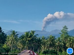
Indonesia , Talang :
Mount Talang, located in the Solok Regency, is one of the most active volcanoes in West Sumatra. This volcano is part of a volcanic complex comprised of the Talang Jantan cone to the east and Talang Betina to the west, separated by approximately 1 km. This complex developed in the central zone of the active Sumatran Fault, specifically in the Sumani and Suliti segments. The northern part of the Sumani segment runs along the northern shore of Lake Singkarak, crosses its southwestern shore, and passes through the towns of Solok, Sumani, and Selayo, terminating north of Lake Diatas, southeast of Mount Talang.
Mount Talang’s activity is strongly influenced by the surrounding tectonic activity. For example, the eruption of April 12, 2005, created two new craters: the Main Crater and the South Crater. This phenomenon is thought to have been triggered by the Mentawai tectonic earthquake (M 6.8) of April 10, 2005. To date, these two craters, as well as the Upper Gabuo and Lower Gabuo fissures, remain at the heart of Mount Talang’s activity.
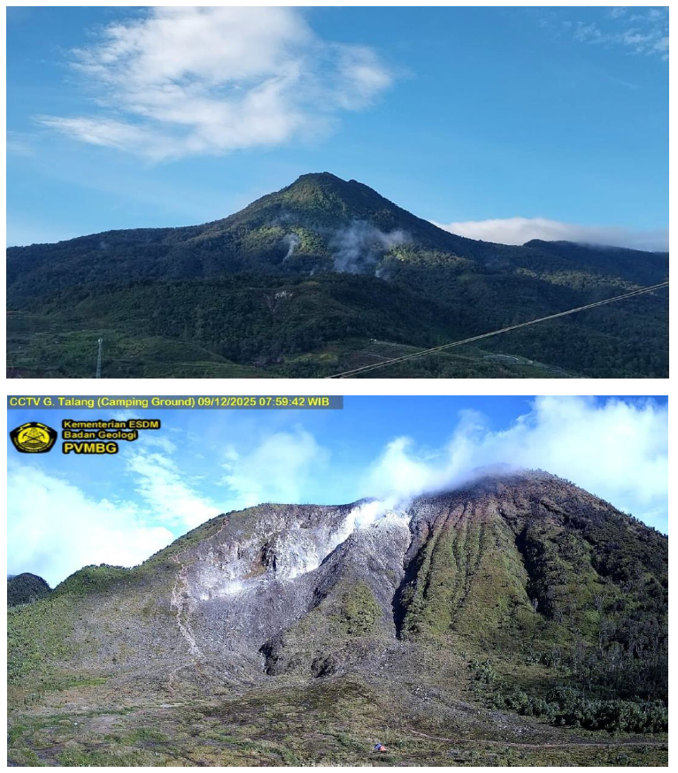
The visual appearance of the crater, as observed from the observation post on Mount Talang in the village of Lembang Jaya (Solok Regency), remains unchanged. White smoke rises between 10 and 75 meters above the summit.
The seismicity of Mount Talang is generally dominated by distant tectonic earthquakes. The number of deep volcanic earthquakes (VT) has been increasing since September 2024. Appendix 2 presents four episodes of intense seismic activity during 2025: April 8, July 25, September 23, and October 9. Seismic activity at Mount Talang between December 1 and 9, 2025, recorded 101 deep volcanic earthquakes (VT), two felt earthquakes of magnitude I to III on the MMI scale, and 14 deep tectonic earthquakes.
On December 10, 2025, at 02:48:27 WIB (Western Indonesian Time), a magnitude 4.7 tectonic earthquake occurred at 0.99° south latitude and 100.71° east longitude, at a depth of 10 km, 18 km from the city of Solok, West Sumatra. Following this tectonic earthquake, by 9:00 WIB (Western Indonesian Time), 227 VT-type earthquakes had been recorded.
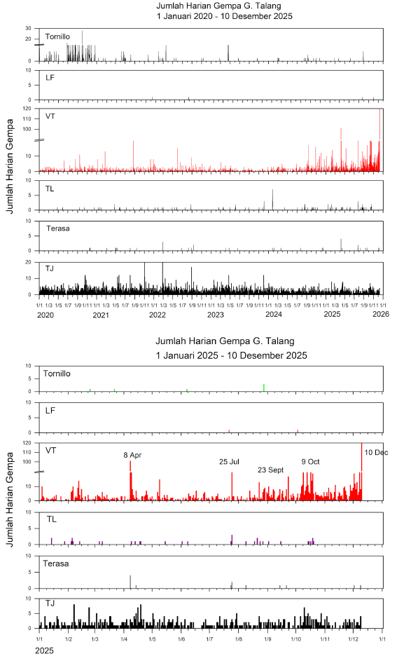
Earthquake swarms occurred four times in 2025: on April 8, July 25, September 23, and October 9 (Appendix 2). The distribution of the epicenters of these swarms shows that the period of September 23 was more concentrated in the crater area than those of April 8 and July 25. Similarly, the depth of the seismic swarms was less on September 23 than on April 8 and July 25. The occurrence of VT-type earthquakes indicates the migration or movement of magma from a deep magma chamber to the surface. Furthermore, VT-type seismic swarms are an indicator of volcanic instability, sometimes followed by eruptions.
Based on visual observations and seismic activity up to December 10, 2025, the activity level of Mount Talang has changed from level I (normal) to level II (WASPADA) on December 10, 2025 at 10:00 AM, Indonesian West Time.
Source et photo : PVMBG.
Colombia , Puracé – Los Coconucos volcanic chain :
Popayán, December 9, 2025, 8:30 a.m.
Regarding the monitoring of activity in the Los Coconucos volcanic chain, the Colombian Geological Survey (SGC), an agency under the Ministry of Mines and Energy, reports the following:
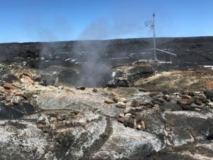
Since the publication of yesterday’s extraordinary bulletin and up to the date of this announcement, earthquakes related to fluid movements within the volcanic edifice have been recorded. These include long-period (LP) earthquakes, tremor pulses (TR), and continuous tremor. This seismicity is primarily located beneath the Puracé volcano crater and is linked to the internal dynamics of gases and their emission into the atmosphere. In addition, low-magnitude seismic signals, associated with rock fracturing, were recorded within a 1.5 km radius around the Purace volcano crater, at depths of less than 3 km.
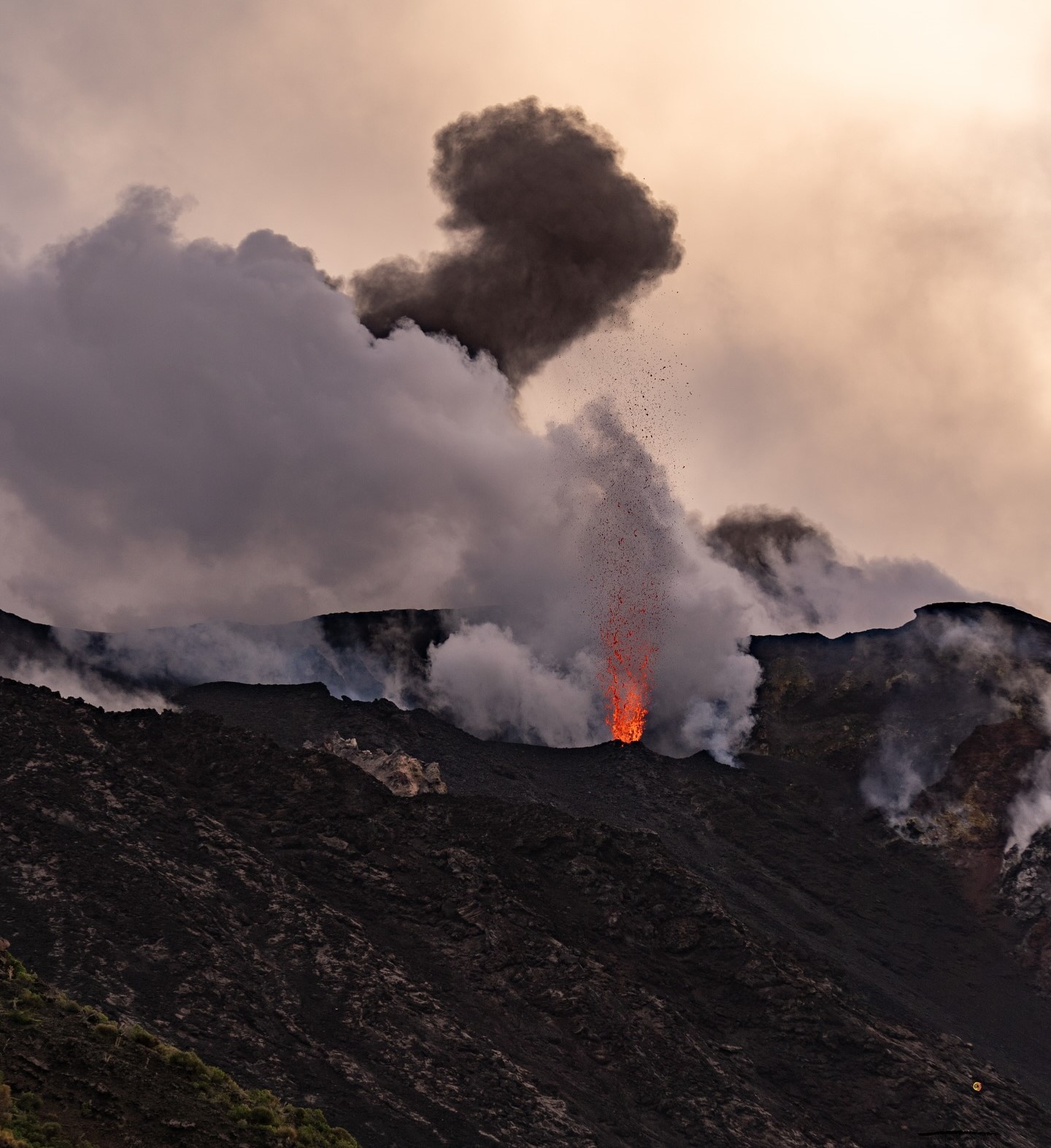
Some seismic activity was accompanied by ash emissions that dispersed mainly to the southeast, following the wind direction. The eruption that occurred this morning at 6:01 a.m. was significant, with ash plumes reaching 1,000 meters above the volcano’s summit. A total of five ash emissions were recorded at the Puracé volcano crater, triggering alerts from the Civil Aviation Authority. Significant levels of sulfur dioxide (SO₂) emissions continue to be detected by satellite, dispersing primarily to the northeast within a 250 km radius of the volcano. Strong sulfur odors were reported by residents of the village of Chapío (Puracé). Furthermore, rising temperatures are still being observed in the crater area, likely related to the emission of hot gases from within the volcano. The orange alert level remains in effect, but temporary fluctuations in volcanic activity are possible, meaning that it may sometimes decrease compared to previous days or weeks.
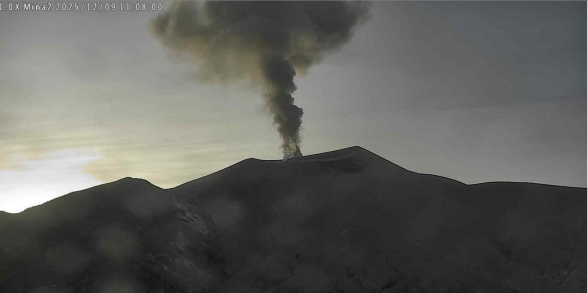
Figure 1. Recording from the Mina camera, located 2.2 km north of the Puracé volcano. Gas and ash column recorded at 6:01 a.m. on December 9, 2025, reaching a height of 1,000 meters above the summit of the Puracé volcano.
In light of the above, the Geological Survey of Colombia (SGC) recommends staying away from the volcano’s crater and surrounding areas, closely monitoring volcanic activity through special bulletins and information published on its official channels, and following the instructions of local and departmental authorities and the National Unit for Disaster Risk Management (UNGRD).
The volcanic activity level remains at ORANGE alert: volcano exhibiting significant variations in monitored parameters.
Source et photo : SGC
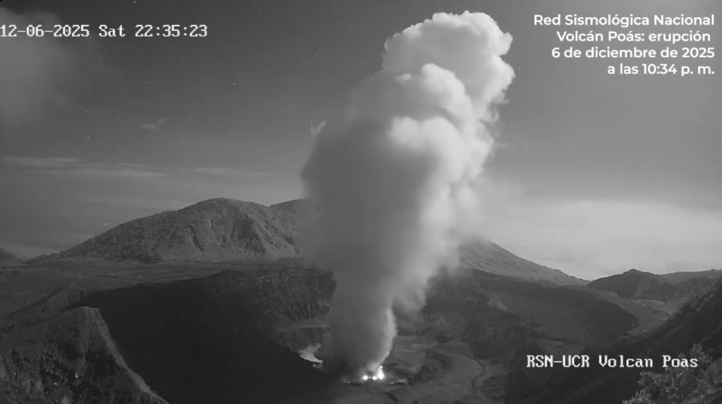
Costa Rica , Poas :
The Poás volcano erupted on December 6, 2025, at 10:34 PM. The eruption lasted approximately 5 minutes and ejected rock debris to a height of 400 to 500 meters above the crater. Ballistic fragments were also ejected around the intracrater lake.
The Seismological Network remains vigilant and is monitoring the activity of this volcano.
Latitude: 10.200
Longitude: -84.233
Altitude: 2,687 m
Observed Activity:
Seismographs and the infrasound network have not detected any eruptions in the last 24 hours. Signs of volcanic tremor are present, with predominant frequency bands at 2.5 and 4.5 Hz. Moderate degassing continues at the fumaroles located at the bottom of the active crater. The Visitor Observatory’s (ExpoGAs) gas detector is recording a SO₂ concentration of less than 0.4 ppm. The OMI instrument on the European SENTINEL satellite detected a mass of 232 tonnes of SO₂ dispersed by wind north of the volcano yesterday, December 7, 2025.
Environmental Conditions:
The area of the active crater remains clear, with prevailing winds blowing from the west.
Activity level: Alert (2)
Sources : RSN , Ovsicori .
Photo : RSN ( capture d’écran).
Guatemala , Santiaguito :
Atmospheric conditions: Partly cloudy
Wind: East
Precipitation: 0.0 mm
Activity:
Constant outgassing is observed above the Caliente dome, reaching a height of 400 meters and dispersing to the west and southwest. Low- to medium-intensity explosions have been recorded, with a column of gas and ash reaching up to 800 meters above the dome, dispersing to the west and southwest.
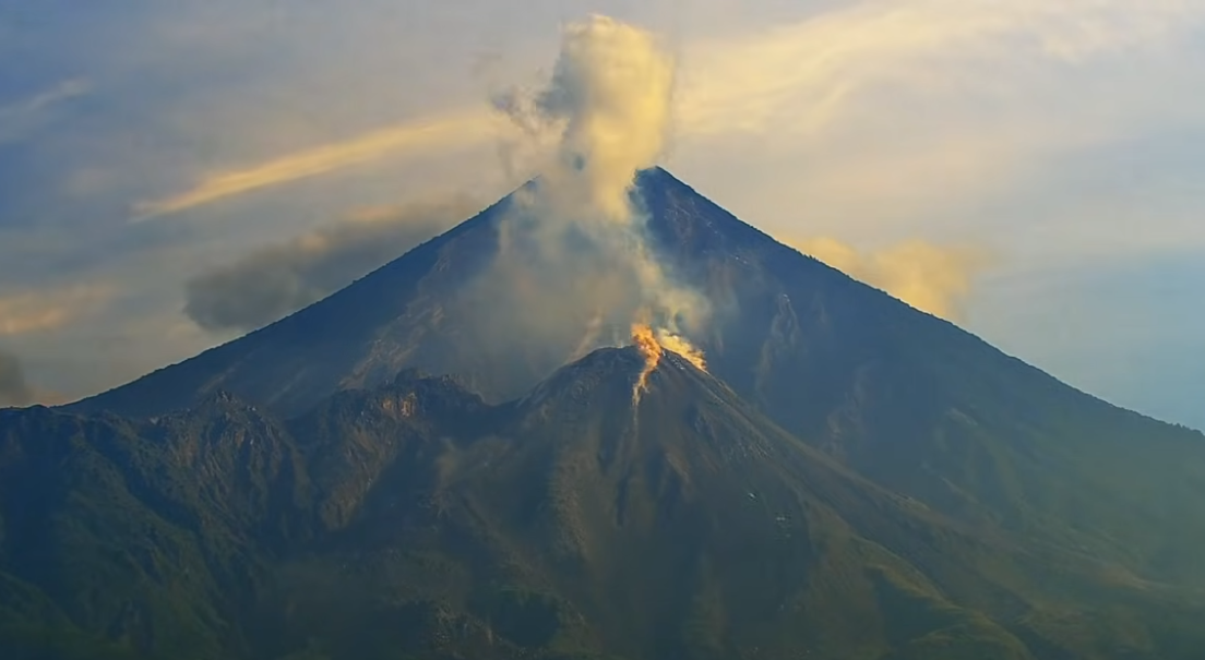
During the night and early morning, incandescence may be observed on the dome and its western and southwestern flanks, resulting from recurring avalanches cascading down these slopes. The possibility of pyroclastic flows cannot be ruled out; therefore, it is necessary to follow the recommendations of Special Bulletin BESAN-063-2025.
In the event of rain in the volcanic zone, lahars of low to moderate intensity may occur along the riverbeds of the southern flank (Nimá, Tambor, Cabello de Angel, among others); therefore, it is necessary to follow the recommendations of Special Bulletin BESAN-012-2025.
Source : Insivumeh
Photo : AFAR TV ( capture d’écran)