December 4 , 2025.
Ethiopia , Ertaale / Hayli Gubbi :
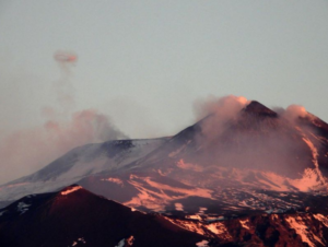
Ertaale :
Satellite images captured Erta Ale and the surrounding region on 23 and 25 November, before and after the 23 November eruption at Hayli Gubbi. The 25 November image showed extensive ashfall across Erta Ale and a new collapsed area, in the northern caldera SE of the previously active pit craters, was about 685 m NNW-SSE and about 385 m ENE-WSW. White plumes rose from both the N and S pit craters in both images.

Hayli Gubbi :
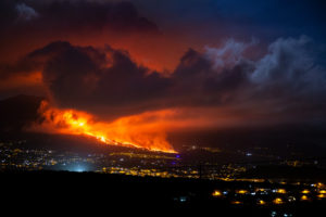
The first recorded explosive eruption at Hayli Gubbi was detected in satellite data at around 1130 on 23 November. Explosions produced a significant gas-and-ash plume that rose 10-15 km (32,800-50,000 ft) a.s.l. and drifted E and ENE over several countries, reaching China by the next day. A plume of pyroclastic material also traveled N about 130 km, spreading about 60 km laterally; it was unknown if the plume was related to a pyroclastic density current (PDC) or ash and gas drifting at a low altitude. Photos in news reports suggested that the eruption produced potentially far-reaching PDCs. According to a Centre for Observation and Modelling of Earthquakes, Volcanoes and Tectonics (COMET) uplift of a few centimeters at most was detected during 13-19 November.
Satellite images captured Hayli Gubbi, Erta Ale, and the region on 23 and 25 November, before and after the eruption. The 25 November image showed extensive ashfall to the NNW, NE, and E. The main crater was enlarged, expanding from around 330 to 390 m in diameter N-S and around 330 to 360 m in diameter E-W. Two new craters had formed. The first was located about 100 m ESE of the main crater and was about 255 m in diameter. The second new crater adjacent to S of the first new crater was smaller, about 110 m in diameter. A white plume was rising from the main crater.
News reports noted that although there were no deaths the ashfall contaminated water and food sources, covering grazing fields for livestock.
Sources: Copernicus, The UK Centre for Observation and Modelling of Earthquakes, Volcanoes and Tectonics (COMET), NDTV, GVP.
Photos : G Vitton. Seifegebreil Shifferaw .
Japan , Sakurajima :
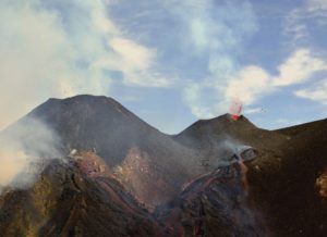
The Japan Meteorological Agency (JMA) reported ongoing eruptive activity at Minamidake Crater (Aira Caldera’s Sakurajima volcano) during 24 November-1 December with five eruptive events and two explosions. Nightly crater incandescence was visible in webcam images. Sulfur dioxide emissions were characterized as extremely high, averaging 4,500 tons per day on 25 November. An explosion at 21h20 on 24 November ejected blocks 600-900 m from the vent; emission characteristics were unknown.
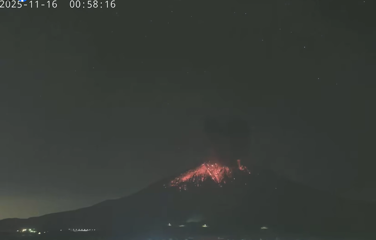
At 02h23 on 27 November an explosion generated an ash plume that rose 3 km above the summit and ejected blocks 300-500 m from the vent. By 08h00 notable ashfall was reported in Kagoshima City (about 10 km W). Ash plumes from eruptive events at 02h54 and at 14h40 on 27 November, at 13h32 on 28 November, and at 16h31 on 30 November rose 1-1.4 km above the crater rim and drifted NE, E, and SE.
The Alert Level remained at 3 (on a 5-level scale), and the public was warned to be cautious within 2 km of both the Minimadake and Showa craters.
Sources : Japan Meteorological Agency (JMA), GVP.
Photo : Webcam
Indonesia , Lewotobi Laki-laki :
SPECIAL REPORT ON THE LEWOTOBI LAKI-LAKI LEVEL IV (AWAS) LAHAR FLOW OF DECEMBER 3, 2025
On December 3, 2025, a lahar flow struck the villages of Klatanlo and Dulipali in Wulanggitang District, East Flores. The flow began at 5:17 a.m. (Central Indonesia Time) and reached a peak amplitude of 47.3 mm at 5:51 a.m. (Central Indonesia Time). Recorded flows ceased at 6:36 a.m. (Central Indonesia Time). Visual monitoring revealed that the mountain was shrouded in mist, preventing observation of crater fumes, but the rumbling of the lahar was audible within a 3 km radius.
On the ground, the initial impacts observed include the Maumere-Larantuka road being blocked by mud and lahar flows, serious damage to three houses in the village of Dulipali, and a house in the village of Klatanlo being buried under 40 cm of mud. This incident also caused power outages following the collapse of several power poles in Dulipali.

Currently, the activity level of Mount Lewotobi Laki-laki remains at Level IV (AWAS). The following recommendations are issued: the public and tourists are advised to avoid all activity within a 6-7 km radius north-northeast of the eruption’s epicenter, to remain calm, and to follow the instructions of local authorities. The public is also urged to disregard information from unreliable sources.
Furthermore, residents of at-risk areas are advised to be vigilant for the risk of mudflows (lahars) during heavy rainfall, particularly in the watersheds originating at the summit of Mount Lewotobi Laki-laki, such as Nawakote, Dulipali, Nobo, Hokeng Jaya, and Nurabelen. Residents affected by ashfall are advised to wear a mask or cover their nose and mouth to protect their respiratory system.
Source et photo : PVMBG.
Kamchatka , Bezymianny :
The Kamchatkan Volcanic Eruption Response Team (KVERT) reported that activity at Bezymianny gradually increased during 21-25 November and intensified during 26-27 November. The Far Eastern Branch of the Russian Academy of Sciences (FEB RAS) reported that during 21-25 November hot avalanches descended the SE flank, the lava dome was occasionally incandescent, and a thermal anomaly was identified in satellite images; weather clouds sometimes obscured views, especially on 23 November. KVERT reported that on 25 November ash plumes from hot avalanches drifted 54 km NE.
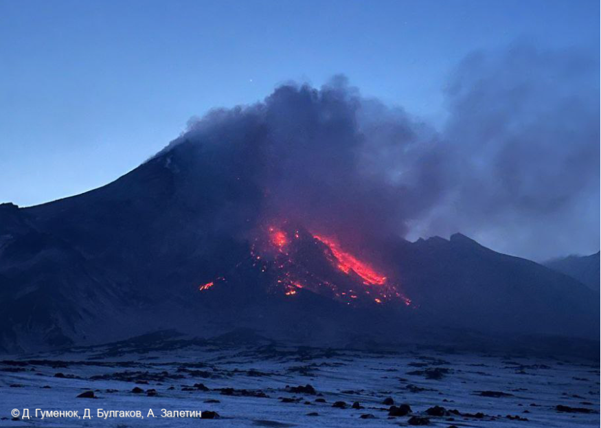
Activity escalated on 26 November. At 02h20 explosions produced ash plumes that rose 7 km (23,000 ft) a.s.l. and drifted 150 km E. At 03h35 explosions generated ash plumes that rose to 10 km (32,800 ft) a.s.l. and drifted E, prompting KVERT to raise the Aviation Color Code to Red (the highest level on a four-color scale). FEB RAS noted that pyroclastic flows traveled down the SE flank. An hour later satellite image captured an ash plume covering a 70 x 50 km area, rising to 11.4 km (37,400 ft) a.s.l. and drifting 70 km W. By 11h19 explosions and ash emissions were no longer being detected so the Aviation Color Code was lowered to Orange. Effusive activity remained high with gas-and-steam emissions and hot avalanches of material descending the flanks. At 21h30 satellite images showed two plumes, one 660 km long and the other 480 km long, each as up to 50 km wide at the leading edge, drifting NW and E. The farthest point of the ash plumes was 1,040 km from the summit. Effusion and hot avalanches continued during 26-27 November. Ash plumes rose 3-4 km a.s.l. and drifted 60 km E from 21h30 on 26 November to 0200 on 27 November; by 03h31 no new ash clouds were visible. At 22h56 the Aviation Color Code was lowered to Yellow. Dates are reported in UTC; specific events are in local time where noted.
Sources: Kamchatkan Volcanic Eruption Response Team (KVERT), Kamchatka Volcanological Station, Institute of Volcanology and Seismology (IVS) of the Far Eastern Branch of the Russian Academy of Sciences (FEB RAS) , GVP.
Photo : D. Gumenyuk, D. Bulgakov, A. Zaletin .
Colombia , Puracé – Los Coconucos volcanic chain :
Popayán, December 3, 2025, 8:45 a.m.
Regarding the monitoring of activity in the Los Coconucos volcanic chain, the Colombian Geological Survey (SGC), an agency under the Ministry of Mines and Energy, reports the following:
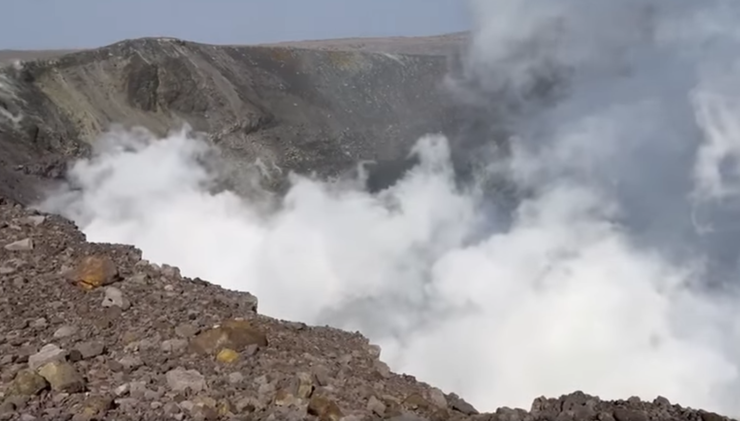
Since the publication of yesterday’s special bulletin and up to the date of this bulletin, seismic signals related to fluid movements, of the tremor (TR) and long-period (LP) type, have been recorded beneath the Puracé volcano crater and are associated with a continuous emission of gas into the atmosphere. Some of these signals were accompanied by small ash emissions, the dispersion of which was primarily influenced by variations in wind patterns.
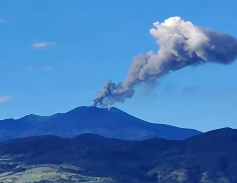
During the period covered by this bulletin, continuous tremor was recorded, and the observed gas and ash plumes reached a height of 100 meters.
A total of five ash emissions were recorded at the Puracé volcano crater, and reports were sent to the Civil Aviation Authority (VONA). These emissions dispersed to the southeast and were reported by the network of ground observers in the Cristales and Agua Hirviendo sectors as light ashfall. The 7:32 a.m. emission yesterday, reported from the village of Río Negro in the Paletará sector, is particularly noteworthy.
As long as the orange alert level remains in effect, temporary fluctuations in volcanic activity are possible. This means that activity may sometimes decrease compared to previous days or weeks, without necessarily indicating a return to a stable level of activity. For a return to a more stable level (yellow alert level), a reasonable time is needed to assess all monitored parameters and determine trends that may indicate reliable stability.
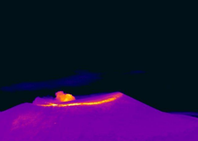
Thermal camera footage from Mina, located 2.2 km north of the Puracé volcano. A plume of gas and ash was recorded at 9:39 PM on December 2, 2025, reaching a height of 100 m above the summit of the Puracé volcano.
Given the above, the Colombian Geological Survey (SGC) recommends staying away from the volcano’s crater and surrounding areas, closely monitoring the situation through special bulletins and other information published on our official channels, and following the instructions of local and departmental authorities and the National Unit for Disaster Risk Management (UNGRD).
The volcanic activity level remains at orange alert: volcano exhibiting significant variations in monitored parameters.
Source : SGC
Photos : sgcol , SGC.