September 11 , 2025.
Philippines , Kanlaon :
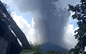
The Philippine Institute of Volcanology and Seismology (PHIVOLCS) reported continuing unrest and an ash emission at Kanlaon during 2-10 September. The seismic network recorded 0-7 daily volcanic earthquakes and daily sulfur dioxide emissions ranged from 762 to 1,922 tonnes per day. Gas-and-steam emissions of variable densities rose 75-700 m above the crater rim and drifted N, NW, and WSW. A period of diffuse ash emissions began at 17h25 on 8 September and lasted about 55 minutes, producing low ash plumes that drifted WSW. At 05h10 on 10 September an ash plume rose 600 m above the crater rim. The Alert Level remained at 2 (on a scale of 0-5); the public was warned to stay out of the 4-km-radius Permanent Danger Zone (PDZ) and pilots were advised to avoid flying close to the summit.
Kanlaon volcano (also spelled Canlaon) forms the highest point on the Philippine island of Negros. The massive andesitic stratovolcano is covered with fissure-controlled pyroclastic cones and craters, many of which are filled by lakes. The largest debris avalanche known in the Philippines traveled 33 km SW from Kanlaon. The summit contains a 2-km-wide, elongated northern caldera with a crater lake and a smaller but higher active vent, Lugud crater, to the south. Eruptions recorded since 1866 have typically consisted of phreatic explosions of small-to-moderate size that produce minor local ashfall.
Sources : Philippine Institute of Volcanology and Seismology (PHIVOLCS), GVP.
Photo : Phivolcs
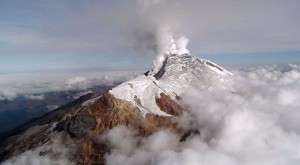
Japan , Shinmoedake :
The Japan Meteorological Agency (JMA) reported that activity continued at Shinmoedake (Shinmoe peak, a stratovolcano of the Kirishimayama volcano group) during 3-9 September. The number of volcanic earthquakes located beneath Shinmoedake, first detected in late October 2024, continued to be frequent; volcanic tremor was detected during 2-3 September. Eruptive events at 11h27 and 13h00 and a period of continuous ash emissions during 13h30-13h42 on 3 September produced ash plumes that rose as high as 2.3 km above the crater rim and drifted SW. Ash plumes from eruptive events at 14h32 and 15h56 later that day rose as high as 1.1 km above the crater rim and drifted SW.
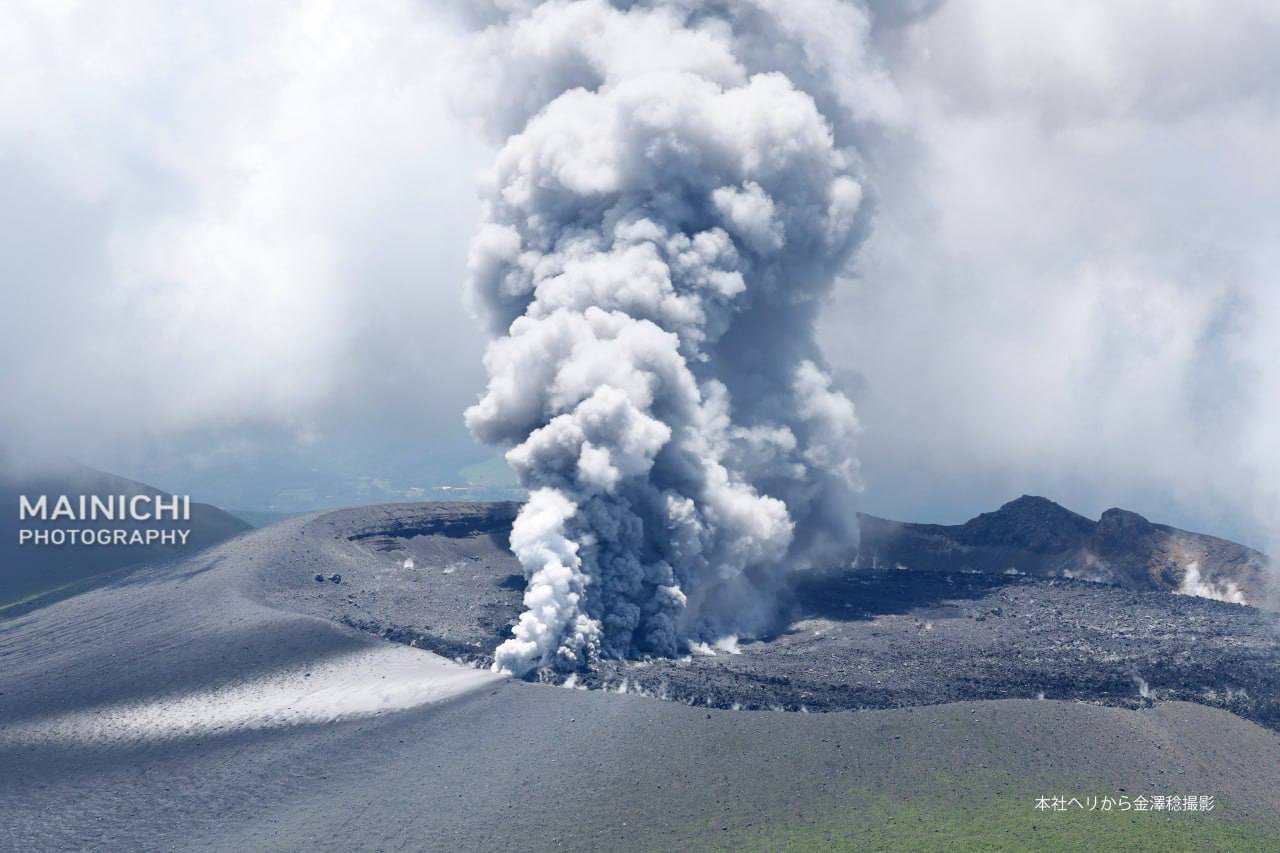
Ashfall reported in areas downwind, including in Kirishima City (21 km SW) and Miyakonojo City (30 km SE), obscured the lines on some roads. Continuous ash emissions during 08h54-10h00 on 5 September rose 100-200 m above the crater rim and drifted SE. At 03h44 on 7 September an ash plume rose 100 m above the crater rim and drifted E. Continuous ash emissions during 20h33-22h31 on 7 September rose 100 m above the crater rim and drifted E. Fumarolic plumes rose as high as 10 m above the fissures on the W flank during 5-8 September.
The Alert Level remained at 3 (on a 5-level scale) and the public was warned to exercise caution within 3 km from Shinmoedake Crater.
Sources: Japan Meteorological Agency (JMA) , GVP.
Photo : Mainichi via Alex Terry / FB.
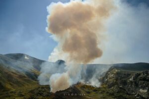
Chile , Planchon Peteroa :
Seismology
Seismological activity during this period was characterized by:
116 VT-type earthquakes, associated with rock fracturing (volcano-tectonics). The most energetic earthquake, with a local magnitude (LM) of 1.0, was located 1.8 km north-northwest of the volcanic edifice, at a depth of 4.0 km.
5,581 LP-type earthquakes, associated with fluid dynamics within the volcanic system (Long Period). The magnitude of the strongest earthquake, evaluated using the reduced displacement (RD) parameter, was 21 cm².
3,481 TR-type earthquakes, associated with sustained fluid dynamics within the volcanic system (TRemor). The magnitude of the strongest earthquake, evaluated using the reduced displacement (RD) parameter, was 8 cm².
Fluid Geochemistry
Three atmospheric sulfur dioxide (SO2) emission anomalies were detected near the volcanic complex using Sentinel-5 image processing via the SO2 Flux Calculator platform on August 25, 26, and 27.
Satellite Thermal Anomalies
During the second half of August, low-power thermal anomalies, reaching a maximum of 0.4 MW, were recorded by the VIIRS 375 sensor. No major anomalies attributable to volcanic activity were reported, according to the Mid-Infrared Volcanic Activity Observation (MIROVA).
Furthermore, no other thermal radiance anomalies were identified during analytical processing of Sentinel 2-L2A satellite images using false-color band combinations.
Geodesy
Geodetic activity for the period was characterized by:
– GNSS vertical deformation rates, with magnitude variations less than 0.2 cm/month, a value considered low. – Horizontal variation rates at GNSS monitoring stations, with variations of around 0.2 cm/month, a value considered low.
– Radar interferometry (InSAR) of Sentinel 1A (Single Look Complex-SLC) images revealed no signs of deformation due to poor coherence caused by the heavy snow cover in the area.
Therefore, no significant changes associated with the deformation of the volcanic system were observed.
Surveillance Cameras
Images provided by the fixed camera installed near the volcanic complex recorded degassing events with a maximum height of 500 m above the crater level on August 23, without any pyroclastic material being identified. No signs of incandescence were observed.
Satellite geomorphological analysis
Based on analysis of Planet Scope and Sentinel 2 L2A satellite images, no morphological changes or recent activity features were identified. No morphological variations attributable to volcanic activity were recorded during this period. The source of the degassing was identified in the Southwest Crater, which hosts a crater lake.
The Planchón-Peteroa volcanic complex maintains activity above its baseline, characterized by high-productivity seismic activity associated with fluid dynamics (LP and tremor), accompanied by transient increases in the RSAM, variations in the SSAM, and a slight increase in the frequency of VT-type earthquakes. Importantly, on August 25, a very low-frequency LP (VLP) signal was recorded, temporally coinciding with the detection of SO₂ by satellite platforms. Taken together, these data suggest heat transfer from deeper levels that activated the surface hydrothermal system, generating increased degassing. A plausible interpretation is the sustained pressurization of the system, which could facilitate a greater gas flow toward the surface. Although other monitoring parameters remain stable, this type of behavior preceded previous eruptive cycles, primarily associated with the emission of pyroclastic material.
YELLOW TECHNICAL ALERT: Changes in the behavior of volcanic activity
Source et photo : Sernageomin .
Indonesia , Bur Ni Telong :
REDUCTION OF MOUNT BUR NI TELONG’S ACTIVITY LEVEL, ACEH PROVINCE, FROM LEVEL II (WASPADA) TO LEVEL I (NORMAL) ON SEPTEMBER 8, 2025
Bur Ni Telong is a stratovolcano with an elevation of 2,624 m and coordinates of 96° 49′ 16″ E and 4° 46′ 10″ N. On August 2, 2025, Mount Bur Ni Telong’s activity level decreased from Level I (Normal) to Level II (Waspada) due to an increase in deep (VA) and shallow (VB) volcanic earthquakes.
Seismic observations in August 2025 showed an increase in VA-type earthquakes on August 12 and 13, 2025, reaching 30 VA-type earthquakes, and on August 21 and 22, 2025, reaching 24 VA-type earthquakes. However, this increase was not accompanied by an increase in shallow volcanic (VB) earthquakes.
From September 1 to 7, 2025, the seismicity of Mount Bur Ni Telong decreased, with only six type VA earthquakes recorded. Visual observations indicated relatively low activity in the crater, with no smoke. This indicates a decrease in pressure and a lack of continuous magmatic activity reaching the surface, thus preventing the release of gas or an increase in crater temperature.
Based on these visual and instrumental observations, the activity level of Mount Bur Ni Telong was lowered from Level II (waspada) to Level I (normal) as of September 8, 2025, at 9:00 a.m. Western Indonesian Time.
Source : PVMBG.
Photo : rafina2802 /wordpress.com
Tonga Archipelago , Home Reef :
The Tonga Geological Services reported no indications of activity at Home Reef during 16 August-1 September. A comparison of satellite images from 11 and 28 August showed minor to no visible changes. Both images showed a diffuse gas plume rising from the crater area and discolored water around the island. There were yellow sulfur deposits in and around the main crater. The dimensions of the main vent crater and of the island were unchanged; the main vent crater was about 210 m N-S and 120 m E-W and the island measured 550 x 420 m. The Aviation Color Code remained at Yellow (the second lowest level on a four-level scale, the Maritime Alert Level remained at Orange (the third level on a four-level scale) with advice to stay at least 2 nautical miles (3.7 km) from the island, and the Alert Level for residents of Vava’u and Ha’apai remained at Green (the first level on a four-level scale).

Home Reef, a submarine volcano midway between Metis Shoal and Late Island in the central Tonga islands, was first reported active in the mid-19th century, when an ephemeral island formed. An eruption in 1984 produced a 12-km-high eruption plume, large amounts of floating pumice, and an ephemeral 500 x 1,500 m island, with cliffs 30-50 m high that enclosed a water-filled crater. In 2006 an island-forming eruption produced widespread dacitic pumice rafts that drifted as far as Australia. Another island was built during a September-October 2022 eruption.
Sources : Tonga Geological Services, Government of Tonga , GVP.
Photo : gvp / P.J.R. Shepherd (Royal New Zealand Air Force; courtesy of John Latter, DSIR, published in SEAN Bull., 1984).