June 20 , 2025.
Italy / Sicily , Etna :
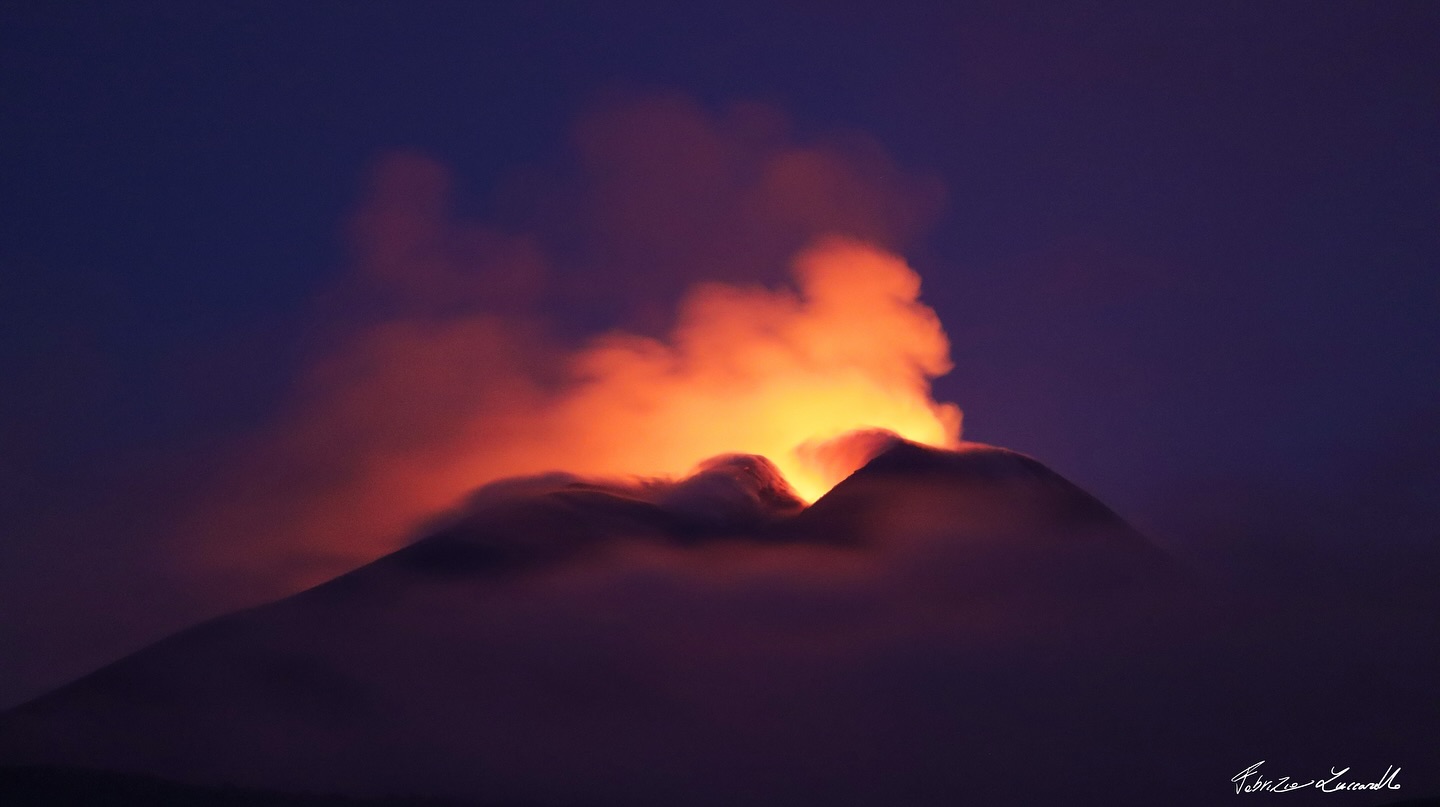
Etna Activity Statement, June 19, 2025, 12:20 PM (10:20 UTC)
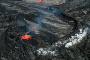
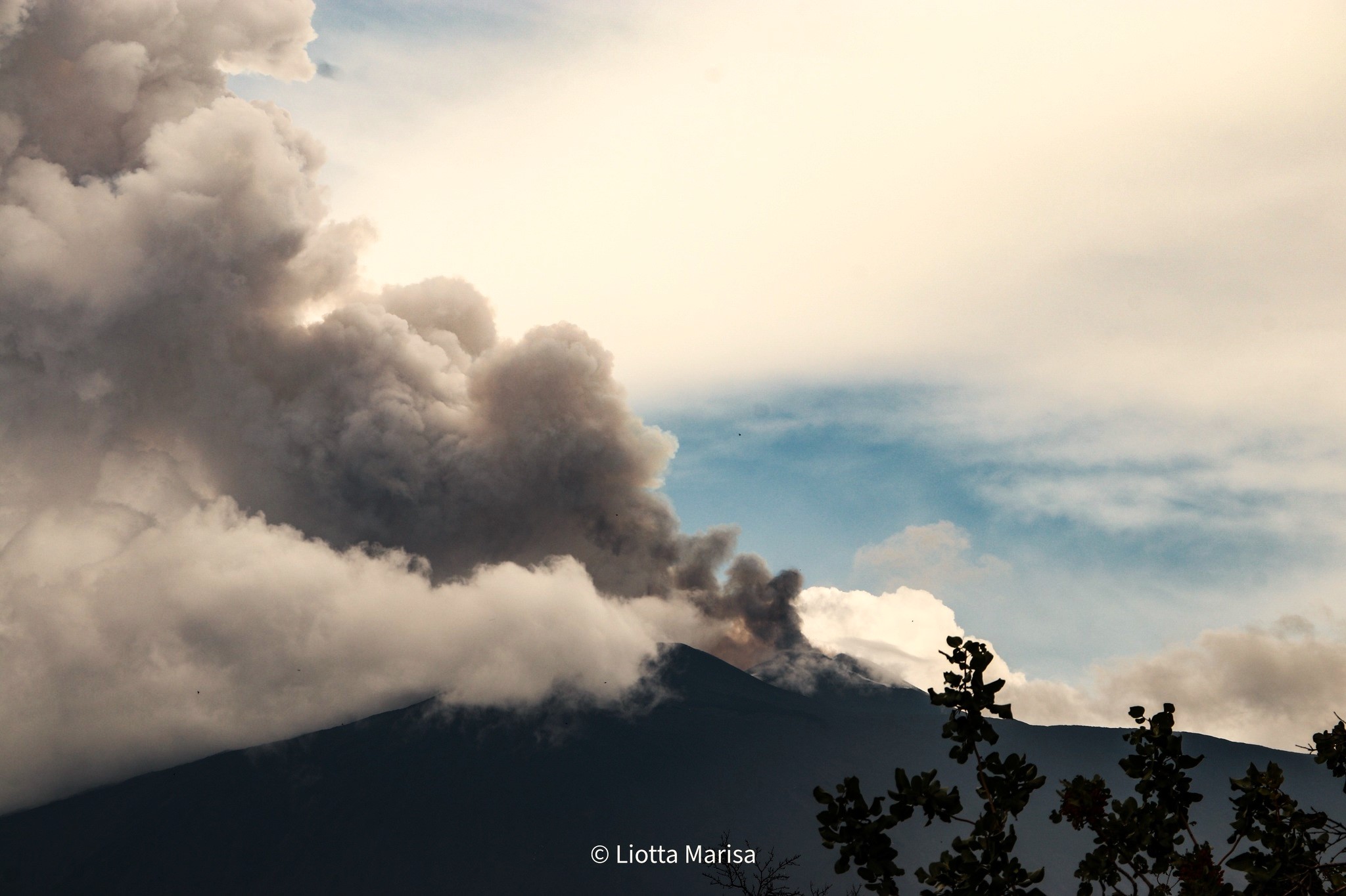
The National Institute of Geophysics and Volcanology, Osservatorio Etneo, reports that the eruptive activity, reported in the 4:01 UTC press release, continued with the formation of Strombolian explosions visible starting around 4:10 UTC. This activity produced a volcanic cloud that, at 7:30 UTC, reached an altitude of approximately 6,000 meters above sea level and is dispersing mainly towards the north.
In addition, a lava flow was observed from the southeast crater, feeding a small flow towards the Valle del Leone, visible on surveillance cameras starting around 3:55 UTC. At 9:35 UTC, a small flow was also visible towards the southeast.
It should be noted that the presence of clouds limits visibility and detailed observation of eruptive activity. Compared to the last press release, the average amplitude of volcanic tremor continued to increase until approximately 4:30 AM (UTC). Thereafter, it showed a quasi-stationary trend with high, albeit oscillating, values until 9:30 AM (UTC), at which time the amplitude values continued to increase. For technical reasons, the location of the centroid of volcanic tremor sources remains unreliable. The detection of infrasonic events, in addition to technical problems, is hampered by the adverse weather conditions affecting the volcano. Along with the increase in the amplitude of volcanic tremor at 9:30 AM (UTC), a significant increase in the amplitude of infrasonic events was observed. The infrasonic events, localized, are located in the Southeast crater. Ground deformation signals showed a variation of about 0.20 microradians at the Punta Lucia inclinometer station and a stress variation of about 106 nanostrains at the Monte Ruvolo dilatometer station.
No significant variation is measured in the available permanent GNSS network data.
Press release on Mount Etna activity, June 19, 2025, 11:47 PM (21:47 UTC).
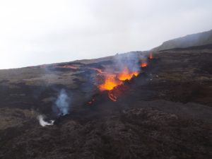
The National Institute of Geophysics and Volcanology, Osservatorio Etneo, announces the end of the eruptive activity described in previous press releases. During the day, due to deteriorating weather conditions, it was not possible to observe the eruptive activity continuously. Images acquired by video surveillance cameras allowed for the observation of sustained Strombolian explosions between 10:00 and 11:00 UTC. An inspection by INGV-OE staff detected the presence of volcanic ash in Randazzo. Slight ash fallout was also reported in Gioiosa Marea. Regarding the lava flow, CCTV footage showed that at 14:35 UTC, the flow toward Valle del Leone was still well fed. This lava flow is currently cooling.
Compared to the last press release, the average amplitude of the volcanic tremor continued to increase, reaching its maximum value around 9:50 UTC. Subsequently, a quasi-stationary trend was observed, with high, albeit fluctuating, values until 1:00 PM (UTC), at which time the amplitude values clearly decreased, finally reaching low amplitude values at 4:20 PM (UTC), comparable to those observed before the eruption. The center of gravity of the volcanic tremor sources is currently located just east of the Voragine crater, at an altitude of approximately 2,900 m above sea level.
Parallel to the phase of decreasing volcanic tremor amplitude, a significant decrease in the amplitude and number of infrasonic events was observed. Subsequently, the few infrasound events recorded were characterized by modest amplitudes and were located in correspondence with the northeast crater. Ground deformation signals showed a total variation of about 0.30 microradians at the Punta Lucia tilt station and a deformation variation of about 150 nanostrains at the Monte Ruvolo station, up to 14:20 UTC.
No significant variation was measured in the data from the permanent GNSS network.
Updates will be provided shortly.
Source : INGV.
Photo : Liotta Marisa , Fabrizio Zuccarello .
Indonesia , Awu :
INCREASED SEISMICITY OF AWU VOLCANO, NORTH SULAWESI, JUNE 19, 2025
Awu Volcano is an active volcano located in the Sangihe Islands Regency, North Sulawesi Province. Its seismic activity has been increasing since April 2024, particularly during shallow volcanic earthquakes. Volcanic swarms occurred on August 24 and 25, 2024, with 364 shallow volcanic earthquakes recorded. Awu Volcano is currently at Level II (Waspada) since February 2, 2025.
Seismic monitoring on June 18, 2025, showed an increase in the seismicity of shallow volcanic earthquakes, reaching 55 events. On June 19, 2025, from 0:00 to 18:00 (local time), 81 shallow volcanic earthquakes, 3 deep volcanic earthquakes, and 1 low-frequency earthquake were recorded. This increase in seismicity should be monitored given the potential hazard of Mount Awu, which may manifest itself through magmatic or phreatic eruptions. A risk of lava dome collapse is also possible if the pressure in the magmatic system increases significantly.
Given the increase in shallow volcanic earthquakes and the activity level remaining at Level II (Waspada), the public is advised not to enter the crater of Mount Awu or to carry out any activities within a 3 km radius of the crater center. The public is urged to remain calm and comply with the recommendations issued by the Geological Agency, through the Center for Volcanology and Geological Disaster Mitigation, and not to be disturbed by false and irresponsible information regarding the activity of Mount Awu.
The activity level of Mount Awu will be reassessed periodically or in the event of a significant change in activity.
Source et photo : PVMBG
Chile , Lascar :
Seismology
Seismological activity during the period was characterized by:
6 VT-type seismic events, associated with rock fracturing (volcano-tectonics).
9 LP-type seismic events, associated with fluid dynamics within the volcanic system (long period). The magnitude of the largest earthquake, estimated using the reduced displacement (DR) parameter, was 4 cm².
Fluid Geochemistry
Sulfur dioxide (SO₂) emission data obtained by differential optical absorption spectroscopy (DOAS), corresponding to the Emu station, located 6 km east-southeast of the active crater, showed an average SO₂ flux of 1,254 t/d for the period evaluated, with a maximum daily value of 2,572 t/d on June 12. These values would be linked to a seasonal effect, with strong winds affecting the measurements of this gas.
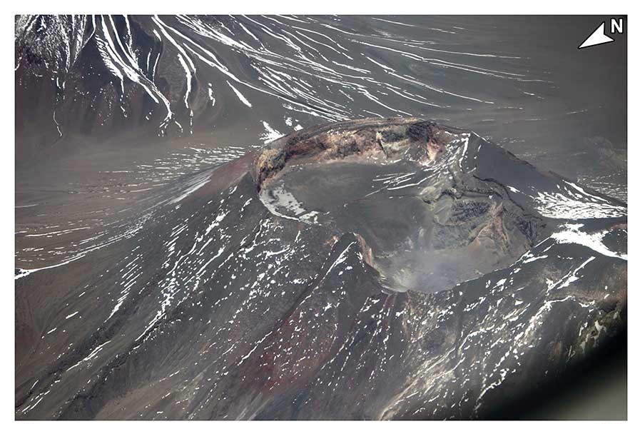
Satellite Thermal Anomalies
During this period, 25 thermal alerts were recorded in the area associated with the volcano, using the MIROVA platform. The maximum value was 3.3 MW for the MODIS sensor on June 3. Sentinel 2-L2A satellite images from June 1, 6, and 11, combined with the bands, show the continuity of the radiance pattern characterized by three zones within the active crater. Similarly, the total radiance area calculated by the NHI (Normalized Hotspot Indices) platform for the active crater indicates 6,300 m² for June 8, a value considered moderate.
Surveillance Cameras
When weather conditions permitted, white degassing columns were recorded, mainly in an east-southeast direction, with a maximum height of 420 m above the crater on June 7. Incandescence was identified on June 6, 9, 10, and 15, and observed intermittently during the nights of the period assessed.
In recent weeks, a gradual decline has been observed in the instrumental data, with a lower occurrence and intensity of seismic activity related to volcanic processes. Meanwhile, daily sulfur dioxide (SO₂) fluxes remain below the threshold considered abnormal for this volcano, and there is no evidence of volcanic deformation. All of the above suggests a stabilization of volcanic dynamics, indicating a low probability of migration to more active states that would stimulate surface activity. However, thermal and radiative anomalies are still recorded in the active crater. It should be noted that Láscar Volcano has historically recorded minor explosions accompanied by few instrumental signals; therefore, this type of phenomenon may still occur.
In view of the above, it is determined that the system has gradually returned to the instrumental parameters considered in its basic threshold, modifying its technical alert to: GREEN TECHNICAL ALERT: Active volcano with stable behavior – No immediate risk.
Source : Sernageomin
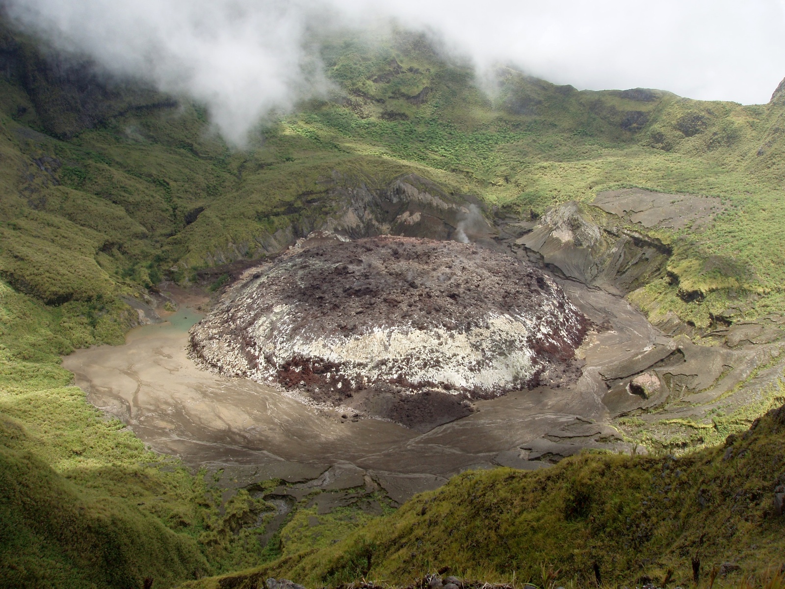
Colombia , Puracé – Los Coconucos volcanic chain:
Popayán, June 17, 2025, 3:30 p.m.
Regarding the monitoring of the activity of the Puracé volcano and the Los Coconucos volcanic chain, the Colombian Geological Survey (SGC), an entity attached to the Ministry of Mines and Energy, reports that:
During the week of June 10-16, 2025, seismic activity recorded an increase in the number of earthquakes compared to the previous week; however, the energy released remained low.
The earthquakes associated with rock fracturing were located mainly between the Puracé and Piocollo volcanoes, at depths between 1 and 3 km, with magnitudes less than 1.0. The remaining seismic activity was scattered northwest and southwest of the Puracé volcano, at distances between 15 and 18 km from the crater. The earthquakes linked to fluid movements were located under the crater of the Puracé volcano, at a depth of less than 1 km, and are characterized by their low energy input.
Satellite and ground-based detection instruments recorded moderate levels of sulfur dioxide (SO₂) emissions. Furthermore, the slow deformation process continued between the Puracé, Piocollo, and Curiquinga volcanic edifices.
Visible and infrared webcam images continued to reveal degassing processes and thermal anomalies within the Puracé volcano crater and its lateral fumarole, respectively.
On June 14, two events associated with minor secondary mudflows were recorded over the Cocuy ravine basin, caused by the action of precipitation on ash deposited on the slopes of the volcanic chain. In conclusion, continuous degassing from the lateral fumarole and crater of the Puracé volcano continued throughout the week, accompanied by moderate SO₂ emissions, localized seismic activity beneath the Puracé and Piocollo volcanoes, and slow ground deformation, indicating the persistence of an active volcanic system.
In view of the above, the SGC recommends closely monitoring the evolution of volcanic activity through weekly and special bulletins, in addition to information published through official channels, and following the instructions of local and departmental authorities and the National Disaster Risk Management Unit (UNGRD).
The yellow alert remains in effect for volcanic activity: an active volcano exhibiting changes in the baseline behavior of monitored parameters and other manifestations.
Source : SGC.
Photo : Cric-colombia .org
Guatemala , Santiaguito :
Weather conditions: Partly cloudy.
Wind: Southeast.
Precipitation: 16.8 mm.
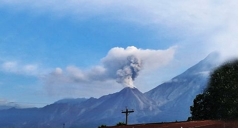
Activity:
Activity has been reported at the Caliente dome of the Santa María-Santiaguito volcanic complex, characterized by white degassing reaching up to 500 meters above the crater. Weak to moderate explosions have been reported, potentially generating columns of gas and ash rising up to 3,500 meters. The ash can disperse 15 to 30 km to the west and northwest, causing fine ashfall on farms and communities near the volcano. During the night and early morning, intense incandescence was observed in the dome’s crater. Collapse and descent of incandescent volcanic material toward the north, southeast, south, and southwest flanks of the dome also occurred. Activity remains high, so it is possible that due to the accumulation of material, explosions or the action of gravity, new collapses will occur, generating large-scale pyroclastic flows towards the southwest, south and southeast.
Source : Insivumeh .
Photo : Conred