May 24 , 2025.
Hawaii , Kilauea :
Friday, May 23, 2025, 9:40 AM HST (Friday, May 23, 2025, 19:40 UTC)
19°25’16 » N 155°17’13 » W,
Summit Elevation 4091 ft (1247 m)
Current Volcano Alert Level: WATCH
Current Aviation Color Code: ORANGE
Activity Summary:
Episode 23 precursory activity continues but summit inflation has slowed significantly. Sustained fountaining is likely to start between today and Sunday. The notable decrease in the rate of summit inflation has likely delayed the onset of sustained fountaining compared to previous episodes.
Kīlauea’s current eruption in Halemaʻumaʻu crater within Kaluapele (the summit caldera) began on December 23, 2024. There have now been 22 episodes separated by pauses in activity. All eruptive activity remains within Hawaiʻi Volcanoes National Park. No significant activity has been noted along Kīlauea’s East Rift Zone or Southwest Rift Zone. Current hazards include volcanic gas emissions and windblown volcanic glass (Pele’s hair) and tephra that have impacted Hawaiʻi Volcanoes National Park and nearby communities.
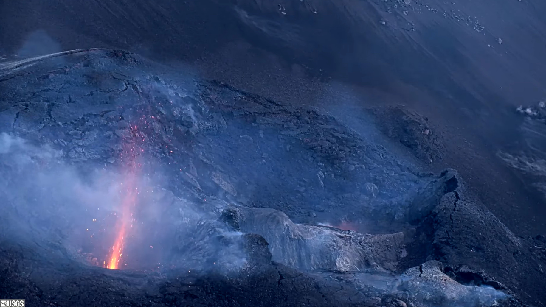
Summit Observations:
Strong glow and intermittent spatter was visible in both vents overnight with occasional flames seen in the north vent. This is similar to activity seen in the lead up to previous sustained fountaining episodes. Precursory activity is expected to increase further before the onset of sustained fountains.
The rate of summit inflation has slowed significantly, with tiltmeters at Uēkahuna (UWD) and Sandhill (SDH) recording net zero inflation since Wednesday. Small variations in summit tilt rates are not uncommon, but this represents a departure from previous inter-episode trends. Total inflationary tilt recorded at UWD is approximately 9 microradians since the end of episode 22 on May 16. Low level tremor continues beneath Halemaʻumaʻu crater.
The average sulfur dioxide (SO2) emission rate remains around 1,200 tonnes per day (t/d), similar to rates recorded during prior pauses.
Source et photo : HVO.
Alaska , Spurr :
Friday, May 23, 2025, 12:15 PM AKDT (Friday, May 23, 2025, 20:15 UTC)
61°17’56 » N 152°15’14 » W,
Summit Elevation 11070 ft (3374 m)
Current Volcano Alert Level: ADVISORY
Current Aviation Color Code: YELLOW
Unrest continues at Mount Spurr. The level of activity is still above background, but lower than observed in early 2025. The likelihood of an eruption has declined since March, but fluctuations in unrest are not uncommon, and explosive eruptions like those in 1953 and 1992 are still possible. Should unrest escalate, we expect seismicity at higher levels than present, lasting weeks or months, more robust gas emissions, and higher deformation rates.
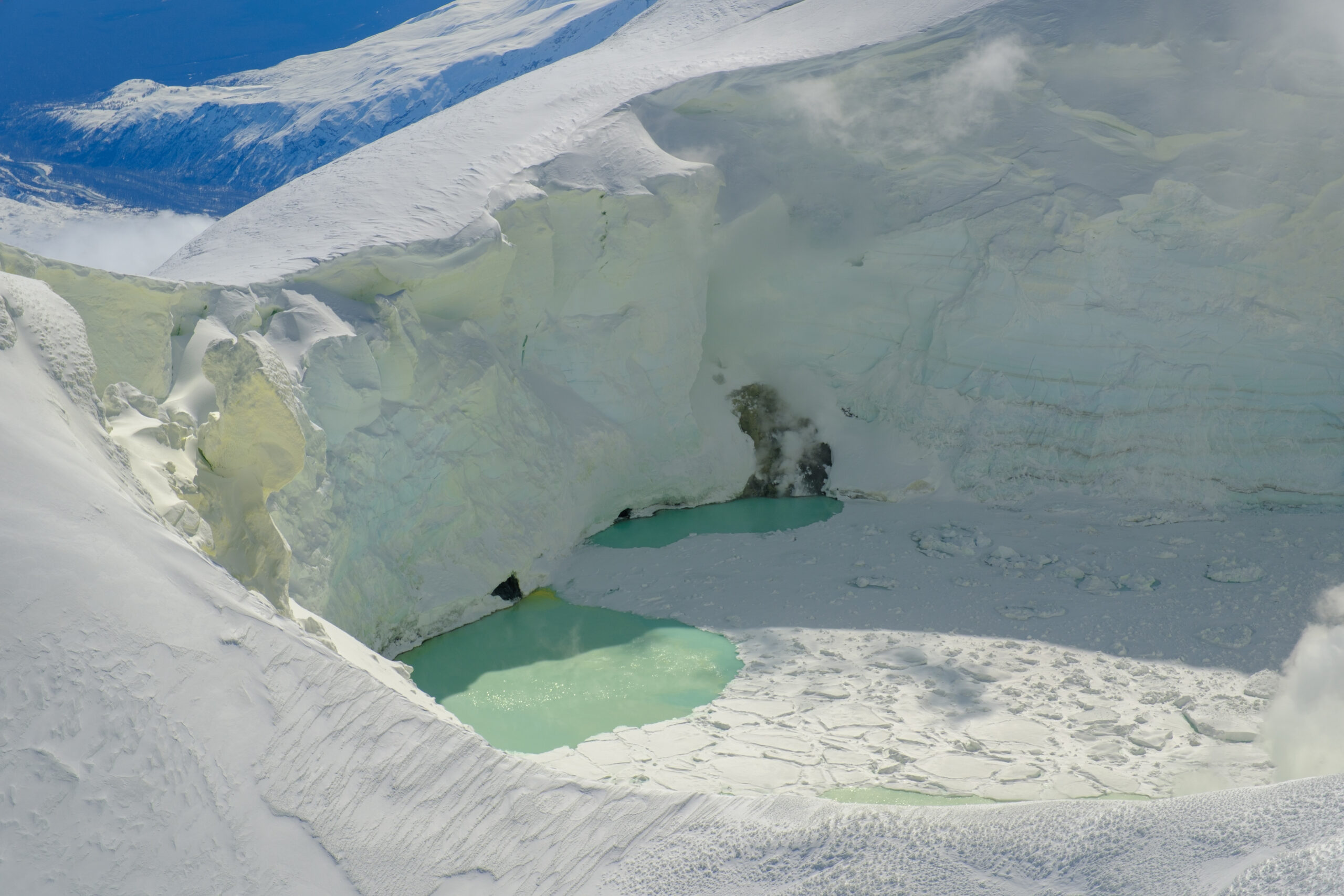
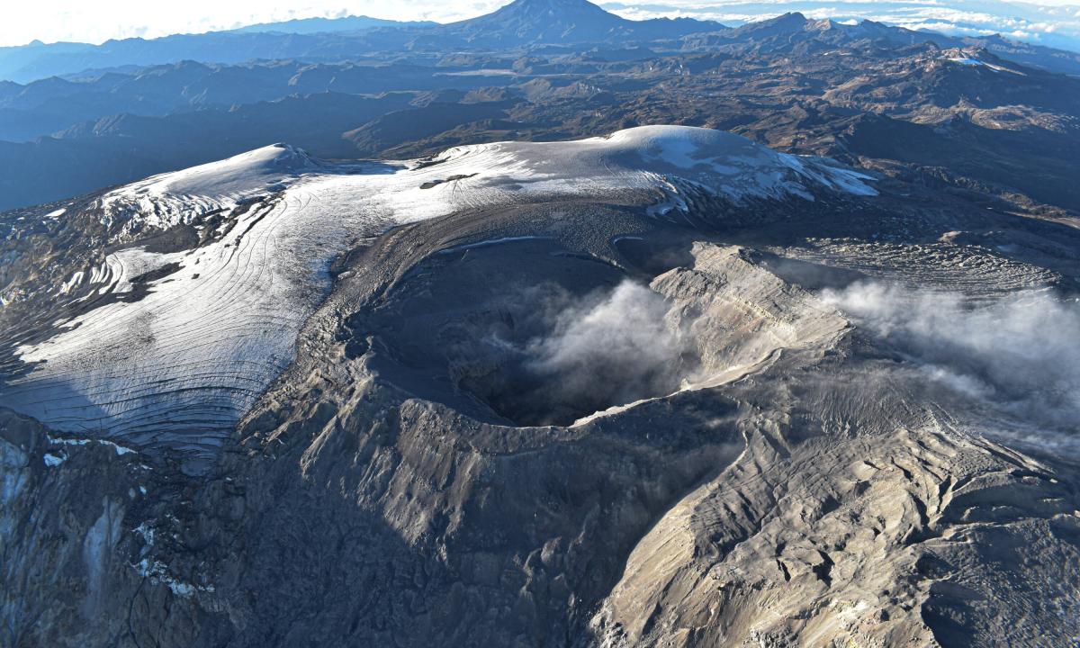
View of the Mount Spurr summit crater lake on an April 25 overflight and gas survey. The water is greenish blue to yellow, due to suspected sulfur precipitates in the water. Floating ice covers the southern half of the lake. The image is looking southeast with two fumarolic areas exposed under recently melted ice visible.
During the past week, 115 earthquakes were located with most of the quakes smaller than magnitude 1. This is a slight increase in located earthquakes compared to the previous eight weeks. Smaller quakes that cannot be located also occur several times per hour. Ground deformation at Mount Spurr has slowed over the past month, like the pause that occurred for several weeks in November and December 2024. Although it has slowed over the past month, an apparent increase in observed deformation over the past two weeks is likely due to seasonal environmental factors affecting the equipment.
Views of the summit from local web cameras showed a vapor plume when viewing conditions were clear. No significant surface changes were observed at Crater Peak. Weak sulfur dioxide emissions were detected several times in satellite data this week when clouds did not obscure the volcano summit.
Source : AVO.
Photo : Loewen, Matt / AVO/USGS.
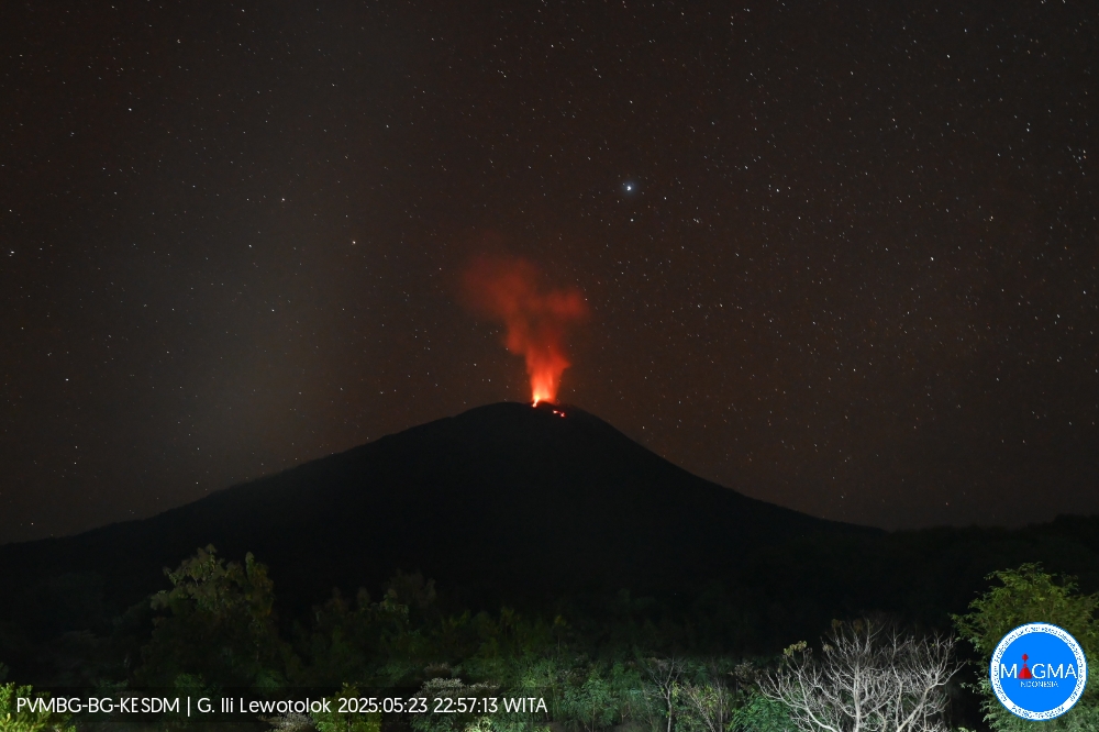
Indonesia , Ili Lewotolok :
An eruption of Mount Ili Lewotolok occurred on Friday, May 23, 2025, at 10:57 PM WITA with an observed ash column height of ± 400 m above the peak (± 1823 m above sea level). The ash column was observed to be gray with moderate intensity, oriented northwest. This eruption was recorded on a seismograph with a maximum amplitude of 19.7 mm and a duration of 65 seconds.
VOLCANO OBSERVATORY NOTICE FOR AVIATION – VONA
Issued : May 23 , 2025
Volcano : Ili Lewotolok (264230)
Current Aviation Colour Code : ORANGE
Previous Aviation Colour Code : orange
Source : Ili Lewotolok Volcano Observatory
Notice Number : 2025LEW014
Volcano Location : S 08 deg 16 min 19 sec E 123 deg 30 min 18 sec
Area : East Nusa Tenggara, Indonesia
Summit Elevation : 4554 FT (1423 M)
Volcanic Activity Summary :
Eruption with volcanic ash cloud at 14h57 UTC (22h57 local).
Volcanic Cloud Height :
Best estimate of ash-cloud top is around 5834 FT (1823 M) above sea level or 1280 FT (400 M) above summit. May be higher than what can be observed clearly. Source of height data: ground observer.
Other Volcanic Cloud Information :
Ash cloud moving to northwest. Volcanic ash is observed to be gray. The intensity of volcanic ash is observed to be medium.
Remarks :
Eruption recorded on seismogram with maximum amplitude 19.7 mm and maximum duration 65 second.
Source et photo : Magma Indonésie .
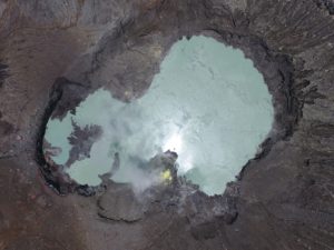
Colombia , Nevado del Ruiz :
Manizales, May 20, 2025, 5:15 a.m.
Monitoring the activity of the Nevado del Ruiz volcano, the Colombian Geological Survey (SGC), an entity affiliated with the Ministry of Mines and Energy, reports that:
During the week of May 13-19, 2025, the volcano continued to exhibit unstable behavior. Compared to the previous week, the main variations in the monitored parameters were:
– Seismic activity associated with rock fracturing processes within the volcanic edifice increased in the number of recorded earthquakes and the seismic energy released. The earthquakes were located mainly in the Arenas crater and on the south-southwest and northeastern flanks of the volcano, at distances less than 6 km from the crater. To a lesser extent, they were found scattered on other flanks of the volcano, at distances of up to 12 km from the crater. The depth of the earthquakes ranged from less than 1 km to 7 km from the volcanic summit. The highest magnitude of the week was 2.0, corresponding to the earthquake recorded on May 15 at 3:16 a.m., located 3 km south-southwest of the crater, at a depth of 4 km measured from the volcanic summit. This earthquake occurred during a slight increase in seismic activity.
– Seismic activity related to the lava dome located at the crater floor continued to be recorded, showing a slight decrease in the number of events and an increase in their seismic energy, while remaining at low levels.
– Seismic signals related to fluid dynamics in volcanic conduits decreased in the number of recorded earthquakes and in the seismic energy released. The energy levels of the seismic signals remained at low values. Thanks to the cameras (conventional or thermographic) used to monitor the volcano, it was possible to confirm a pulsatile emission of ash.
– The emission of water vapor and volcanic gases into the atmosphere, mainly sulfur dioxide (SO₂), through the Arenas crater varied throughout the week. The estimated values of the flux associated with SO₂ degassing were similar to those recorded the previous week, despite the fact that atmospheric conditions (wind direction and speed) were not conducive to data collection. Satellite monitoring, which is being carried out in addition to the evaluation of this parameter, also revealed significant SO₂ releases.
– The vertical height of the gas column remained mainly below the 500 m measured above the volcanic summit, with a maximum of 700 m. In terms of dispersion, the column also reached a maximum height of 700 meters during the only confirmed gas and ash emission of the week, recorded on May 17 at 8:37 a.m. The dispersion direction showed a preferential trend toward the northwest flank of the volcano, and occasionally, toward the west and west-northwest. – When monitoring thermal anomalies at the floor of Arenas Crater using satellite monitoring platforms, detection was limited due to persistent cloudy atmospheric conditions in the area. Despite this, some reports of low energy levels were obtained.
Source et photo : SGC
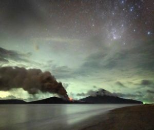
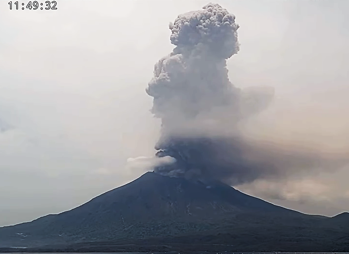
Japan , Sakurajima :
Published on May 23 at 7:22 PM:
An eruption occurred at Sakurajima (Minami-dake summit crater) at 6:56 PM on the 23rd, and a cloud of smoke and ash rose over 3,500 m above the crater rim.
Assuming the smoke reaches 4,000 m above the crater rim, the cloud will rise northward from the crater (toward Kajiki, Aira City).
The ash was blown away, and by 1:00 AM on the 24th, a relatively large amount of ash had fallen on Kagoshima City (Sakurajima), and the ashfall was expected to reach Kuju City, Oita Prefecture.
It is estimated that the amount of ash expected in every city, town, and village by 1:00 a.m. on the 24th will be quite significant.
In areas where relatively large amounts of ash are expected, please take precautions against ash by using an umbrella or mask, etc., and drive slowly.
Source : JMA.
Photo : Capture d’écran webcam .