May 09 , 2025.
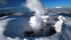
Alaska , Spurr :
Unrest continues at Mount Spurr volcano. Small volcanic earthquakes were detected beneath the volcano over the past day. No noteworthy activity was observed in clear satellite views. Clear web camera views yesterday morning showed a vapor plume at the summit. Possible sulfur dioxide emissions were evident in TROPOMI satellite data from yesterday morning. Clouds obscure the volcano today and nothing of note was observed. Although low-level unrest continues, no changes have been observed in the monitoring data to indicate that the volcano is moving closer to an eruption.
Based on previous eruptions, changes from current activity in the earthquakes, ground deformation, summit lake conditions, and fumarolic activity would be expected if magma began to move closer to the surface. Therefore, if an eruption occurred, it would be preceded by additional signals allowing warning.
The volcano is monitored using local seismic, infrasound, web camera, and GNSS (GPS) stations along with regional infrasound, lightning networks, and satellite data.
Source : AVO .
Photo : Loewen, Matt / AVO/USGS.
Philippines , Bulusan :
The Philippine Institute of Volcanology and Seismology (PHIVOLCS) reported continuing unrest at Bulusan during 30 April-5 May. The seismic network recorded 50-127 daily volcanic earthquakes, including 2-52 periods of volcanic tremor during 30 April-3 May that each lasted 1-58 minutes. Gas-and-steam emissions of variable densities rose as high has 500 m above the summit and drifted E, WNW, W, and WSW; views were obscured on 2 May. Daily averages of sulfur dioxide emissions ranged from 809 to 2,131 tonnes per day. The Alert Level remained at 1 (the second lowest level on a scale of 0-5). The public was reminded not to enter the 4-km-radius Permanent Danger Zone (PDZ) and to be vigilant within the 2-km Extended Danger Zone (EDZ) on the SE flank.
Luzon’s southernmost volcano, Bulusan, was constructed along the rim of the 11-km-diameter dacitic-to-rhyolitic Irosin caldera, which was formed about 36,000 years ago. It lies at the SE end of the Bicol volcanic arc occupying the peninsula of the same name that forms the elongated SE tip of Luzon. A broad, flat moat is located below the topographically prominent SW rim of Irosin caldera; the NE rim is buried by the andesitic complex. Bulusan is flanked by several other large intracaldera lava domes and cones, including the prominent Mount Jormajan lava dome on the SW flank and Sharp Peak to the NE. The summit is unvegetated and contains a 300-m-wide, 50-m-deep crater. Three small craters are located on the SE flank. Many moderate explosive eruptions have been recorded since the mid-19th century.
Sources: Philippine Institute of Volcanology and Seismology (PHIVOLCS), GVP.
Photo : Drew Zuñiga
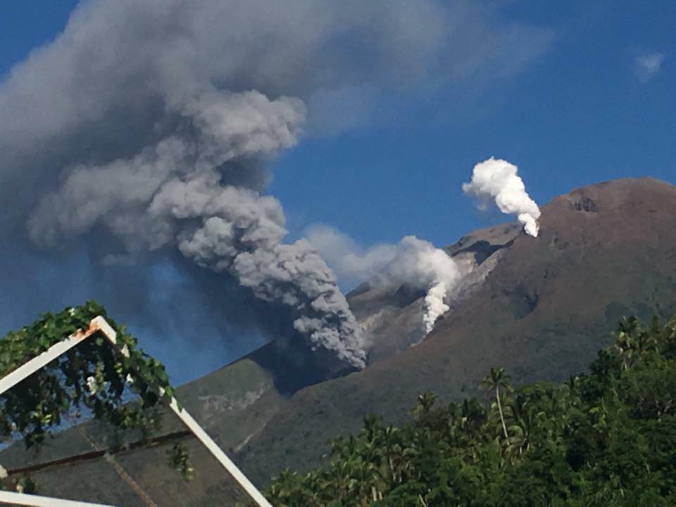
Indonesia , Ibu :
An eruption of Mount Ibu occurred on Thursday, May 8, 2025, at 10:57 PM WIT with an observed ash column height of ± 600 m above the peak (± 1925 m above sea level). The ash column was observed to be gray in color with a thick intensity, oriented toward the Southeast. This eruption was recorded on a seismograph with a maximum amplitude of 28 mm and a duration of 68 seconds.

VOLCANO OBSERVATORY NOTICE FOR AVIATION – VONA
Issued : May 08 , 2025
Volcano : Ibu (268030)
Current Aviation Colour Code : ORANGE
Previous Aviation Colour Code : orange
Source : Ibu Volcano Observatory
Notice Number : 2025IBU745
Volcano Location : N 01 deg 29 min 17 sec E 127 deg 37 min 48 sec
Area : North Maluku, Indonesia
Summit Elevation : 4240 FT (1325 M)
Volcanic Activity Summary :
Eruption with volcanic ash cloud at 13h57 UTC (22h57 local).
Volcanic Cloud Height :
Best estimate of ash-cloud top is around 6160 FT (1925 M) above sea level or 1920 FT (600 M) above summit. May be higher than what can be observed clearly. Source of height data: ground observer.
Other Volcanic Cloud Information :
Ash cloud moving to southeast. Volcanic ash is observed to be gray. The intensity of volcanic ash is observed to be thick.
Remarks :
Eruption recorded on seismogram with maximum amplitude 28 mm and maximum duration 68 second.
Source et photo : Magma Indonésie .
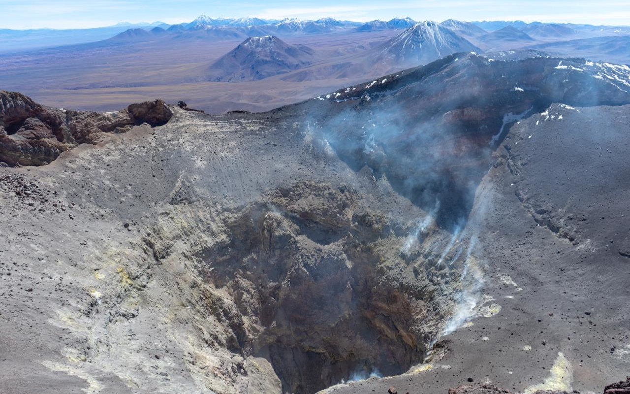
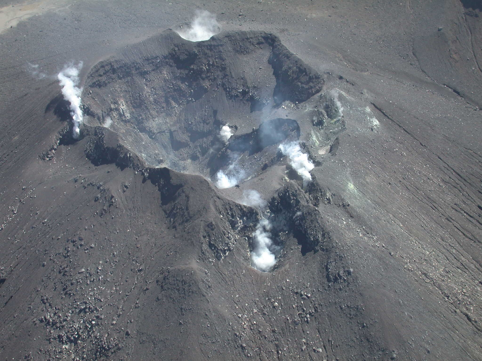
Chile , Lascar :
Seismology
The seismological activity for the period was characterized by the recording of:
13 VT-type seismic events, associated with rock fracturing (Volcano-Tectonic). The most energetic earthquake had a local magnitude (LM) value of 1.5, located 0.9 km east-southeast of the volcanic structure, at a depth of 1.9 km.
15 LP-type seismic events, associated with fluid dynamics within the volcanic system (Long Period). The size of the largest earthquake, estimated using the reduced displacement (RD) parameter, was 6 cm².
1 TR-type seismic event (TRemor), associated with sustained fluid dynamics within the volcanic system over time. The size of the earthquake, estimated using the reduced displacement (RD) parameter, was 2 cm². 1 TO (TOrnillo) type seismic event, associated with fluid dynamics within the volcanic system characterized by its particular waveform. The earthquake size (DR) was less than 0.1 cm2.
Fluid Geochemistry
Sulfur dioxide (SO2) emission data obtained using Differential Optical Absorption Spectroscopy (DOAS) equipment at the Emu station, located 6 km east-southeast (ESE) of the active crater, showed an average SO2 flux value of 1,102 t/d for the period under review, with a maximum daily value of 1,438 t/d on April 18.
Seven anomalies were reported in satellite images obtained by the Tropospheric Monitoring Instrument (TROPOMI) in sulfur dioxide (SO2) emissions into the atmosphere in areas near the volcano. The maximum emission value was recorded on April 23, reaching 166 tons of SO2 mass. These data were published by the Mounts Project and Global Sulfur Dioxide Monitoring.
Satellite Thermal Anomalies
During the period, 30 thermal alerts were recorded in the area associated with the volcano, on the MIROVA platform. The maximum value was 4.9 MW in MODIS (April 26) and 7.9 MW in VIIRS (April 16). Sentinel 2-L2A satellite images from April 17, 19, 22, and 27, combined across multiple bands, show the continued presence of a radiance pattern characterized by three zones within the active crater. Similarly, the total radiant area of the hotspots calculated by the NHI TOOLS platform indicates 10,800 m² for April 29, a value considered moderate.
Geodesy
Geodetic data provided by three GNSS stations measuring the deformation of the volcanic system show values very similar to those of the previous two weeks:
– Low-amplitude displacements of the vertical components of the GNSS stations, not exceeding 0.3 cm/month.
– Slight decrease in the distance between GNSS stations crossing the massif (control line between GNSS stations), at a rate of less than 0.4 cm/month.
Furthermore, it is reported that, based on radar interferometry, no variations have been identified that could be associated with the deformation of the volcanic edifice.
Therefore, there is no evidence of changes in the deformation of the volcanic system.

Surveillance Cameras
Images provided by surveillance cameras installed around the volcano, when weather conditions permitted, recorded whitish degassing columns in an easterly and southeasterly direction, with a maximum value of 700 m above the crater on April 22. Incandescence was observed until April 20 and was not identified again during the period under review.
Instrumental data suggest that the volcanic system continues to experience anomalous internal and surface activity. Recorded seismic activity has been remarkably low compared to previous periods, with a significant decrease since mid-March. Regarding surface activity, recurrent degassing persists, with columns of similar heights to those of the previous two weeks.
Daily sulfur dioxide (SO₂) fluxes remain below the threshold considered abnormal for this volcano. However, satellite alerts continue to be recorded regarding SO₂ emissions, thermal anomalies, and radiation in the active crater, demonstrating the persistence of the anomalous process.
It is hypothesized that the current cycle could be influenced by a greater contribution from the magmatic component, reflected in the persistence of these geochemical and thermal signals, with the possibility of an evolution toward a state of greater activity.
YELLOW TECHNICAL ALERT: Changes in the behavior of volcanic activity
Source : Sernageomin
Photos : Vulcanopro , RudiR/ commons.wikimedia.org .
Colombia , Galeras :
San Juan de Pasto, May 6, 2025, 4:20 p.m.
Monitoring the activity of the Galeras Volcano, the Colombian Geological Survey (SGC), an entity affiliated with the Ministry of Mines and Energy, reports that:
During the week of April 29 to May 5, 2025, the main variations in the monitored parameters compared to the previous week were:
● A slight decrease in seismic activity was observed, while seismic activity related to rock fracture processes within the volcanic edifice remained predominant.
● Earthquakes related to rock fracture were mainly located near the volcanic crater, at depths less than 4 km from the summit of the Galeras Volcano (4,200 m above sea level). Other earthquakes were scattered throughout the volcanic area, reaching distances of up to 15 km, with depths of 15 km from the summit and a maximum magnitude of 0.8.
● Small gas emissions were observed, mainly from the fumarole fields of El Paisita, to the north; and Las Chavas, to the west of the active cone, with low white columns and variable dispersion determined by wind direction.
● Other volcanic monitoring parameters showed stability.
Based on the above, the SGC recommends closely monitoring developments through weekly bulletins and other information published through our official channels, as well as instructions from local and departmental authorities and the National Disaster Risk Management Unit (UNGRD).
Volcanic activity remains on Yellow alert: Active volcano with changes in the baseline behavior of monitored parameters and other manifestations.
Source et photo : SGC.