May 06 , 2025.
Italy / Sicily , Etna :
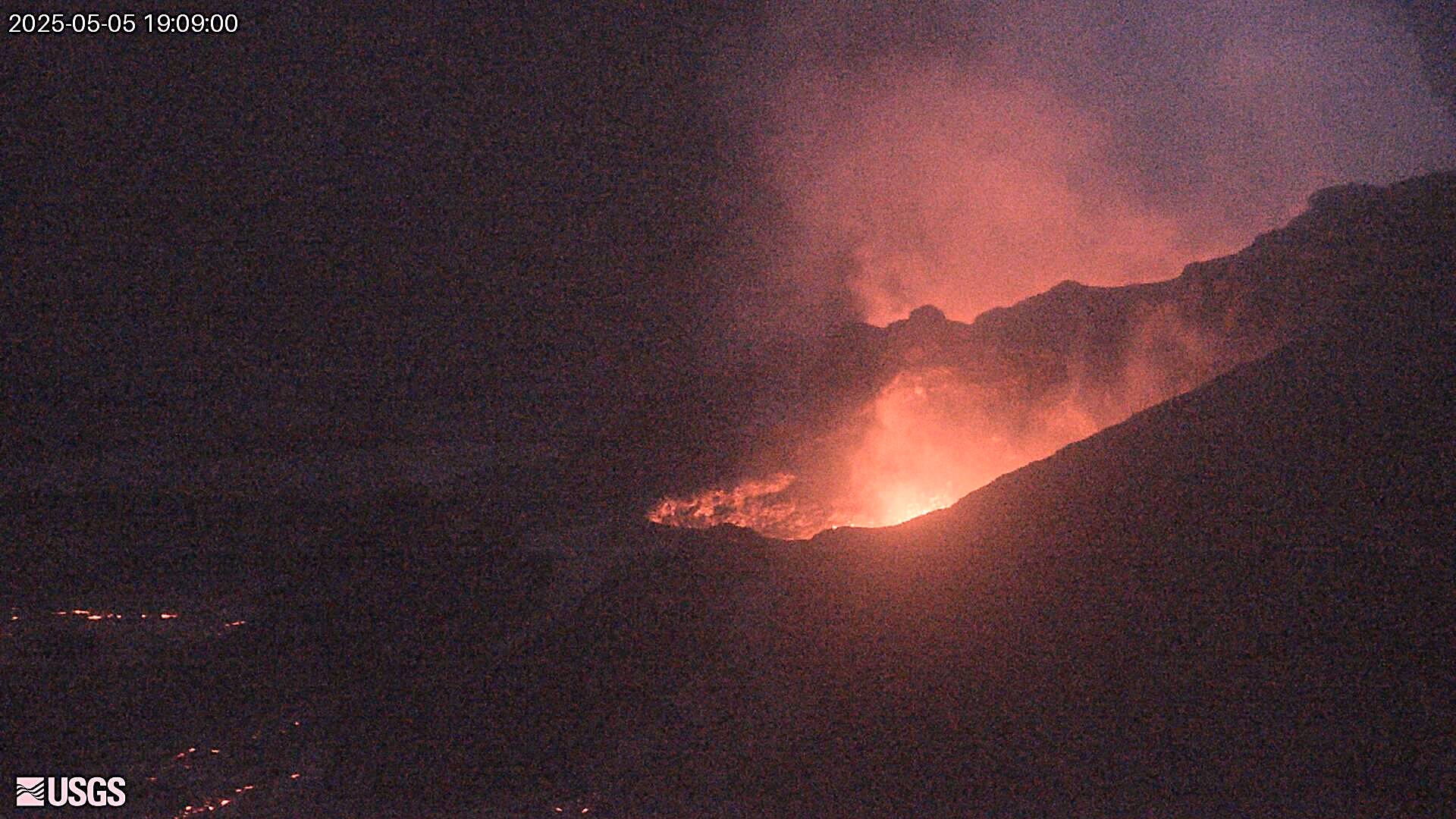
Etna Activity Update, May 5, 2025, 3:06 PM (1:06 PM UTC).
The National Institute of Geophysics and Volcanology, Osservatorio Etneo, reports that due to persistent cloud cover over the volcano’s summit area, it is not possible to observe the ongoing eruptive activity with the video surveillance system. The forecast model indicates that any eruptive clouds produced by the ongoing activity would disperse in an east-northeast direction.
From a seismic perspective, starting around 07:00 UTC, the average amplitude of volcanic tremor showed a rapid increase, reaching the high range around 12:00 UTC. Currently, the values are high, with a tendency to increase further. The centroid of the tremor sources is located in the southeast crater area at an altitude of approximately 2,900 m above sea level. Infrasound activity is currently low, and infrasound events are currently located in the southeast crater area with medium to low amplitudes.
Deformation monitoring networks do not currently show any significant variations.
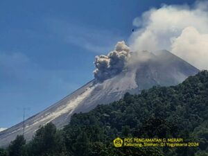
Etna Activity Update, May 6, 2025, 07:21 (05:21 UTC).
The National Institute of Geophysics and Volcanology, Etnean Observatory, reports that eruptive activity at the Southeast Crater continued, in a decreasing manner, during yesterday evening and ended during the night. Two lava flows were emitted, one towards the southeast, dividing into two or three branches, and a smaller one towards the south. During the most intense phase of activity in the afternoon, a slight ash fall occurred in the Fiumefreddo di Sicilia area. From a seismic point of view, the average amplitude of the volcanic tremor reached its maximum value around 14:00 UTC on May 5; subsequently, a continuous decrease in amplitude was observed, down to the medium-low values at which it currently stands. The location of the tremor source centroid is currently in the northeast crater area at an altitude of approximately 2,000 m above sea level. Infrasonic activity appears to be weak and confined to the southeast crater. Deformation data from monitoring networks do not show significant variations. The eruptive phenomenon recorded a modest variation of approximately 17 nanostrains on the DRUV dilatometer.
Further updates will be provided shortly.
Source : INGV.
Photo : Boris Behncke .
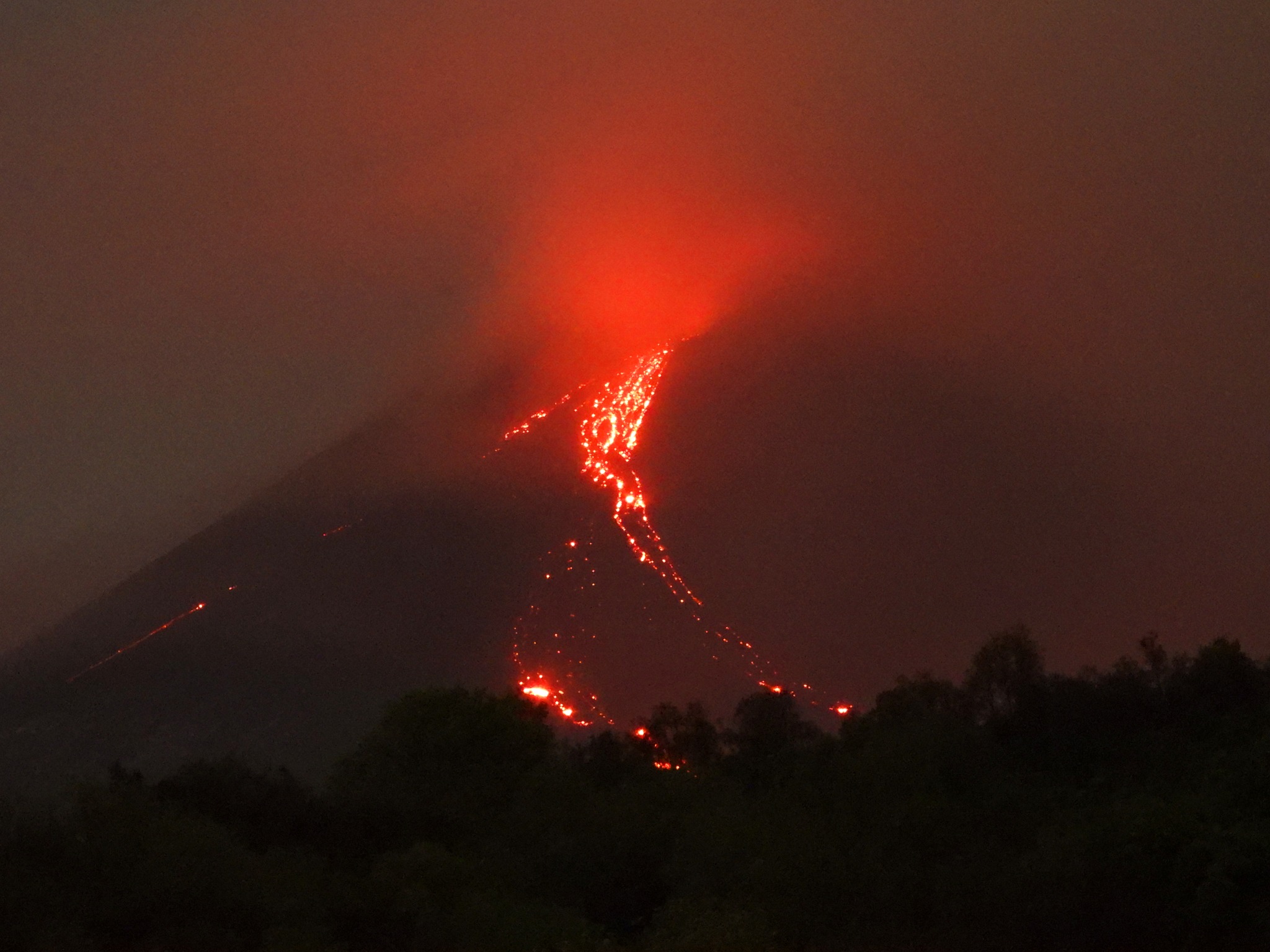
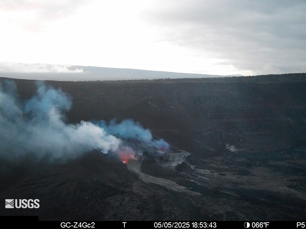
Hawaii , Kilauea :
2025-05-05 11:51:56 HST
A small, slow moving lava flow began erupting from the south vent at about 11:23 am HST. Cyclic dome fountaining continues in the north vent. This behavior may continue as precursory activity to the episode 20 main fountaining.
Monday, May 5, 2025, 8:04 AM HST (Monday, May 5, 2025, 18:04 UTC)
19°25’16 » N 155°17’13 » W,
Summit Elevation 4091 ft (1247 m)
Current Volcano Alert Level: WATCH
Current Aviation Color Code: ORANGE
Activity Summary:
Episode 19 of the ongoing Halemaʻumaʻu eruption ended on May 2. Episode 20 is likely to start in the next 1–3 days.
Kīlauea’s current eruption in Halemaʻumaʻu crater within Kaluapele (the summit caldera) began on December 23, 2024. There have now been 19 episodes separated by pauses in activity. All eruptive activity remains within Hawaiʻi Volcanoes National Park. No significant activity has been noted along Kīlauea’s East Rift Zone or Southwest Rift Zone. Current hazards include volcanic gas emissions and windblown volcanic glass (Pele’s hair) and tephra that have impacted Hawaiʻi Volcanoes National Park and nearby communities.
Summit Observations:
Glow was visible in the north and south vents overnight in multiple summit webcams, with some occasional spatter from the north vent seen in the V1cam. The UWD tiltmeter has recorded over 5 microradians of inflation since the end of episode 19. A sulfur dioxide (SO2) emission rate measured on May 2 was approximately 1,750 tonnes per day, which is typical during the eruption pauses. Strands of volcanic glass known as Pele’s hair from previous episodes are still present throughout the summit area of Hawaiʻi Volcanoes National Park and surrounding communities, and can be remobilized by wind.
Source et photos : HVO
Alaska , Atka Volcanic Complex:
AVO/USGS Volcanic Activity Notice
Current Volcano Alert Level: NORMAL
Previous Volcano Alert Level: ADVISORY
Current Aviation Color Code: GREEN
Previous Aviation Color Code: YELLOW
Issued: Monday, May 5, 2025, 12:00 PM AKDT
Source: Alaska Volcano Observatory
Notice Number: 2025/A289
Location: N 52 deg 19 min W 174 deg 8 min
Elevation: 5030 ft (1533 m)
Area: Aleutians
Volcanic Activity Summary:
No further explosive activity has been detected at the Atka volcanic complex since the small explosive event at 10:34 AKDT on April 25 (18:34 UTC on April 25). Thus, the Aviation Color Code and Alert Level are being reduced to GREEN/NORMAL.
Brief explosive events at Korovin Volcano can occur without significant precursory unrest. Fallout of ash is unlikely to extend much beyond the upper flanks of the volcano.Possible ash clouds generated by such events are expected to be small and dissipate quickly.
Remarks:
The Atka volcanic complex forms the northern part of Atka Island, located about 16 km north of the community of Atka and 1,761 km southwest of Anchorage. The Atka volcanic complex includes a possible older caldera and several younger vents, including Korovin Volcano, Mount Kliuchef, and Sarichef Volcano. Korovin Volcano, a 1553-m-high (5030 ft) stratovolcano, has been the site of most historical volcanic activity, and has a small, roiling crater lake that occasionally produces energetic steam emissions. Korovin has erupted several times in the past 200 years, including 1973, 1987, and 1998, and has likely had small ash emissions as recently as 2005. Typical recent Korovin eruptions produce minor amounts of ash and occasional but small lava flows. Reports of the height of the ash plume produced by the 1998 eruption ranged as high as 10,600 m (35,000 feet) above sea level. Mount Kliuchef is composed of a series of five vents aligned northeast–southwest. The two main summit vents of Kliuchef appear relatively young and the easternmost was probably the source of an 1812 eruption that is sometimes attributed to Sarichef.
Source : AVO
Photo : Lopez, Taryn / AVO / USGS / University of Alaska Fairbanks.
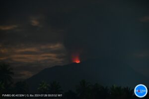
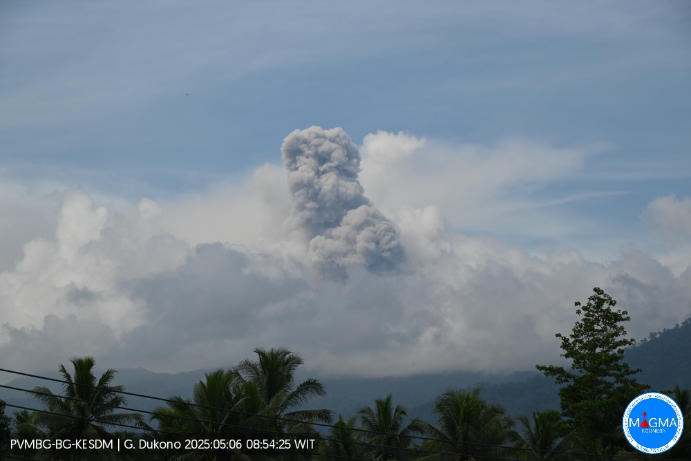
Indonesia , Dukono :
An eruption of Mount Dukono occurred on Tuesday, May 6, 2025, at 09:53 WIT with an observed ash column height of ± 1500 m above the peak (± 2587 m above sea level). The ash column was observed to be white to gray in color with moderate to thick intensity, oriented toward the southeast. At the time of writing, the eruption was still ongoing.
VOLCANO OBSERVATORY NOTICE FOR AVIATION – VONA
Issued : May 6 , 2025
Volcano : Dukono (268010)
Current Aviation Colour Code : ORANGE
Previous Aviation Colour Code : orange
Source : Dukono Volcano Observatory
Notice Number : 2025DUK085
Volcano Location : N 01 deg 41 min 35 sec E 127 deg 53 min 38 sec
Area : North Maluku, Indonesia
Summit Elevation : 3478 FT (1087 M)
Volcanic Activity Summary :
Eruption with volcanic ash cloud at 00h53 UTC (09h53 local).
Volcanic Cloud Height :
Best estimate of ash-cloud top is around 8278 FT (2587 M) above sea level or 4800 FT (1500 M) above summit. May be higher than what can be observed clearly. Source of height data: ground observer.
Other Volcanic Cloud Information :
Ash cloud moving to southeast. Volcanic ash is observed to be white to gray. The intensity of volcanic ash is observed from medium to thick.
Remarks :
Eruption and ash emission is continuing. Eruption recorded on seismogram with maximum amplitude 34 mm. Tremor recorded on seismogram with maximum amplitude 3 mm.
Source et photo : Magma Indonésie .
Costa Rica , Poas :
Daily Volcano Status Report. Date: May 5, 2025, Updated at: 2:50:00 PM.
Latitude: 10.2
Longitude: -84.233
Altitude: 2,687 meters
Observed Activity:
The Poás Volcano continues to erupt, emitting gases, water vapor, aerosols, and ash. Eruptive activity continues with a pattern similar to that observed since March 23, 2025: relatively passive phases of material eruption alternating with phases or pulses of greater gas and ash emission. Seismographs record volcanic tremors with frequency bands between 0.8 and 6 Hz, with a particularly prominent low-frequency signal between 0.8 and 1 Hz associated with fluid transport (water, gas, magma, etc.). Yesterday, May 4, 2025, several eruptive pulses were observed using surveillance cameras, seismographs and infrasound sensors, including one during the night at 8:59 p.m. local time through the Boca A fumarole with ejection of hot ballistic projections (rocks) at low altitude which fell back into the crater area.
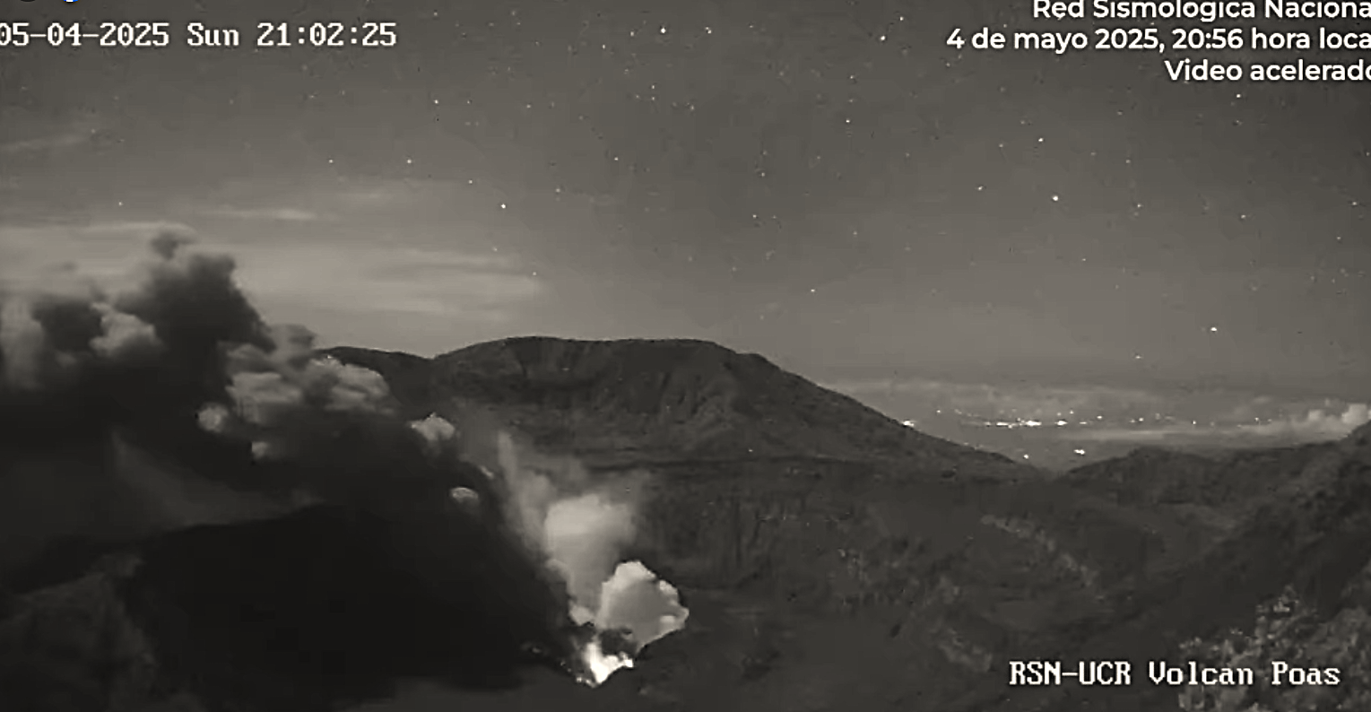
Between May 1 and 5, 2025, molten sulfur was observed burning at night, releasing energy in the form of bright visible light. Sulfur is highly flammable under oxidizing conditions such as those found at the crater floor. The SO2 gas flux measured today, May 5, using mobile DOAS transects yielded an average reading of 3,190 +/- 560 tons/day, slightly lower than those similarly measured in April but still high for what has been historically measured on Poás (de Moor, J.M., direct communication). On April 26, 2025, the SENTINEL satellite detected 2,263 tons/day of SO2.
Environmental Conditions:
At the summit, winds predominate toward the west of the volcano, transporting most of the gas and ash toward this area.
Activity Level: Caution (3)
Source : Ovsicori .
Photo : RSN /UCR , Capture d’écran 06 Mai 2025 .