April 17 , 2025.
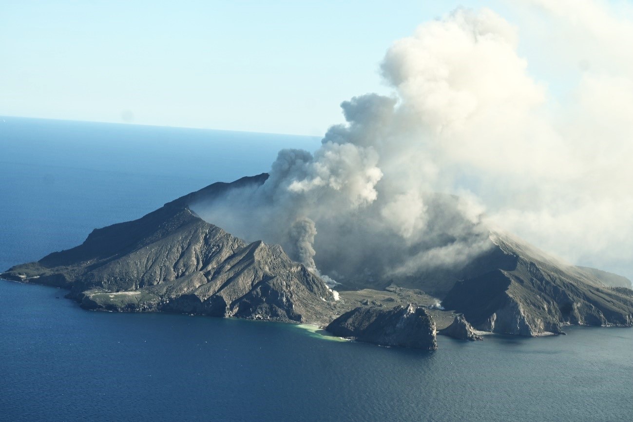
New Zealand , White Island :
Volcanic Activity Bulletin , Thu Apr 17 2025 1:40 PM;
Volcanic Alert Level is raised to 3
Aviation Colour Code remains at Orange
Over the past few months, volcanic ash has been identified more frequently in the Whakaari/White Island steam and gas plume. Evidence of intermittent explosive activity has also been observed during recent observation and gas flights. This gradual increase in volcanic activity leads us to raise the Volcanic Alert Level to Level 3 whereas the Aviation Colour Code remains at Orange.
Despite limited direct observations of activity over the last few weeks, images from the webcams at Whakatāne and Te Kaha continue to record an increase in volcanic ash in the steam and gas plume at Whakaari/White Island. Over the same period, our colleagues at MetService have been able to detect minor amounts of volcanic ash in the plume using satellite imagery. From the coast, this can be seen as a hazy plume trailing downwind from the volcano. These observations indicate that there has been a gradual increase in eruptive activity and in response, the Volcanic Alert Level is now raised to Level 3.
Recent gas and observation flights, and satellite data have confirmed that there has been a gradual increase in the amount of volcanic ash in the plume from Whakaari/White Island. Volcanic ash emissions remain minor and during periods of northerly winds, the plume of gas and ash may be noticed by residents on the coast as sulphur odours. We do not expect ash fall to affect the Bay of Plenty coastline at this time.
During recent observation flights, we have observed impact craters on the main crater floor, indicating that on occasions, more explosive activity has occurred, ejecting rocks several hundreds of metres away from the vent. Explosive events like these are common at Whakaari as active vents grow, periodically become clogged, or gas flux increases.
Monitoring data from our gas flights, thermal InfraRed temperature measurements and the sulphur dioxide (SO₂) emissions detected by satellite, all show slight increases, which is consistent with an overall increase in volcanic activity, and more frequent ash emissions.
Steam, gas, and volcanic ash emissions remain variable as they have been for the past few months and due to our lack of on-island monitoring, it is possible that short-duration eruptions are occurring without being directly recorded. Recent activity is consistent with a low level of eruptive activity and therefore, the Volcanic Alert Level is raised to Level 3. The continued presence of volcanic ash emissions mean that the Aviation Colour Code remains Orange. These levels acknowledge the gradually increased volcanic activity but also reflect the increased level of uncertainty.
Source : Geonet / Geoff Kilgour / Duty Volcanologist .
Photo : Geonet.
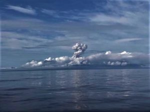
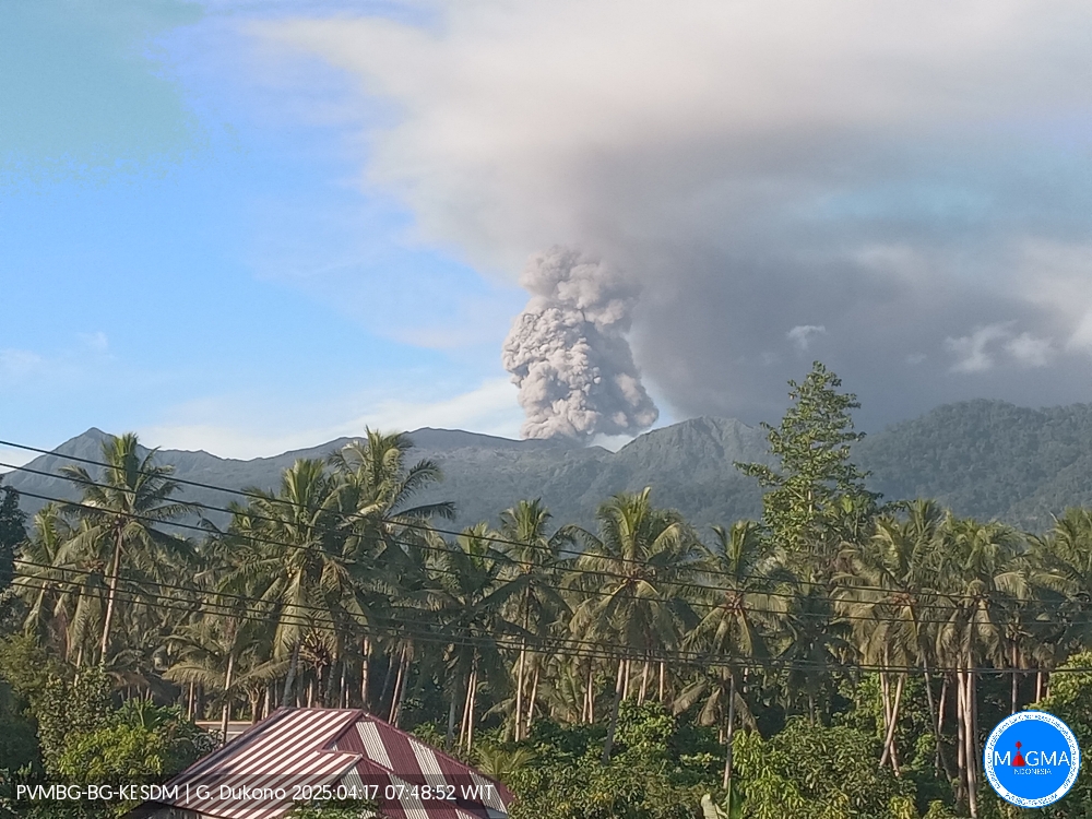
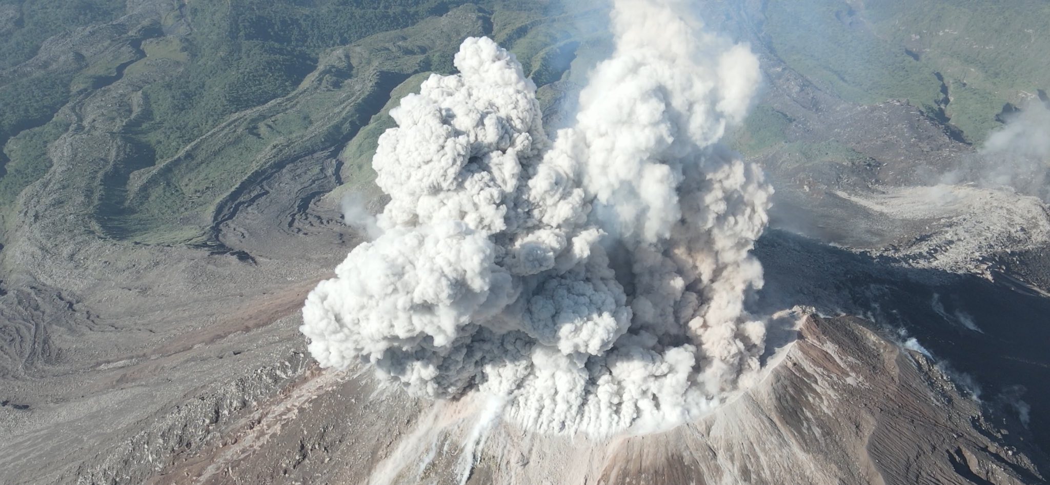
Indonesia , Dukono :
An eruption of Mount Dukono occurred on Thursday, April 17, 2025, at 07:45 WIT with an observed ash column height of ± 900 m above the peak (± 1987 m above sea level). The ash column was observed to be white to gray in color with a thick intensity, oriented northwest. At the time of writing, the eruption was still ongoing.
Seismicity Observation:
288 eruption earthquakes with an amplitude of 6 to 34 mm and a duration of 33.87 to 175.37 seconds.
7 distant tectonic earthquakes with an amplitude of 14 to 30 mm and an earthquake duration of 70.62 to 97.1 seconds.
1 continuous tremor earthquake with an amplitude of 1-4 mm, dominant value 2 mm.
Recommendation
(1) People around Mount Dukono and visitors/tourists should not engage in activities, climb, or approach the Malupang Warirang crater within a 4 km radius. (2) Since volcanic ash eruptions occur periodically and the distribution of ash follows the direction and speed of the wind, so the area where the ash lands is not constant, people around Mount Dukono are recommended to always carry masks/nose and mouth covers to use when needed to avoid the threat of volcanic ash to the respiratory system.
Source et photo : Magma Indonésie .
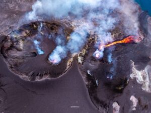
Costa Rica , Poas :
The Observatorio Vulcanológico y Sismológico de Costa Rica-Universidad Nacional (OVSICORI-UNA) reported ongoing inflation and frequent explosions at Poás during 9-15 April. Sulfur dioxide emissions recorded by a mobile Differential Optical Absorption Spectroscopy (DOAS) instrument measured an average of 223 ± 210 tonnes per day (t/d) and a maximum flux of 5,524 ± 854 t/d on 9 April. Seismographs and infrasound sensors recorded volcanic tremor and acoustic signals. Gas-and-ash emissions typically rose 100-400 m above the crater.
At 21h44 on 8 April a large phreatomagmatic event lasting 15-20 minutes produced an ash plume that rose 1.5 km above the crater and drifted SW. Blocks were ejected onto the crater floor. Frequent ash emissions rising less than 100 m above the crater continued following this event. The Washington VAAC reported that an ash plume rose 1.5 km above the crater and drifted S at 23h50 on 8 April, based on webcam imagery. At 07h38 on 9 April there was a transition to continuous ash emissions that rose 300 m above the crater and drifted W.
Light ashfall and a sulfur odor was reported, along with damage to nearby vegetation and crops, on the middle and upper parts of the W flank near San Luis (11 km SW) and Trojas de Grecia. According to the Washington VAAC, at 08h20 on 9 April an ash plume rose to 3 km (9,800 ft) a.s.l. and drifted W, based on webcam images.
During 11h16 and 11h26 on 11 April several short, intense, eruptive events were recorded. Residents of Poás, Grecia (16 km SW), and Zarcero reported a sulfurous odor and symptoms that included headaches, nausea, sore throat, teary eyes, nasal drip, and allergies relating to the gas emissions and volcanic particles. During 12-13 April ash emissions and higher energy tremors and acoustic infrasound signals were recorded; the height of the ash emissions could not be determined due to cloudy weather conditions. On 12 April at 07h10 the Washington VAAC reported a possible ash plume that rose to 3 km (9,800 ft) a.s.l. and drifted SW, though cloudy weather obscured clear views of the summit. The volcano’s Alert Level remained at 3 (the second highest level on a four-level scale) and the Aviation Color Code remained at Orange (the second highest color on a four-color scale).
Sources : Observatorio Vulcanologico y Sismologico de Costa Rica-Universidad Nacional (OVSICORI-UNA), Washington Volcanic Ash Advisory Center (VAAC), GVP.
Photo : Armando Pineda .
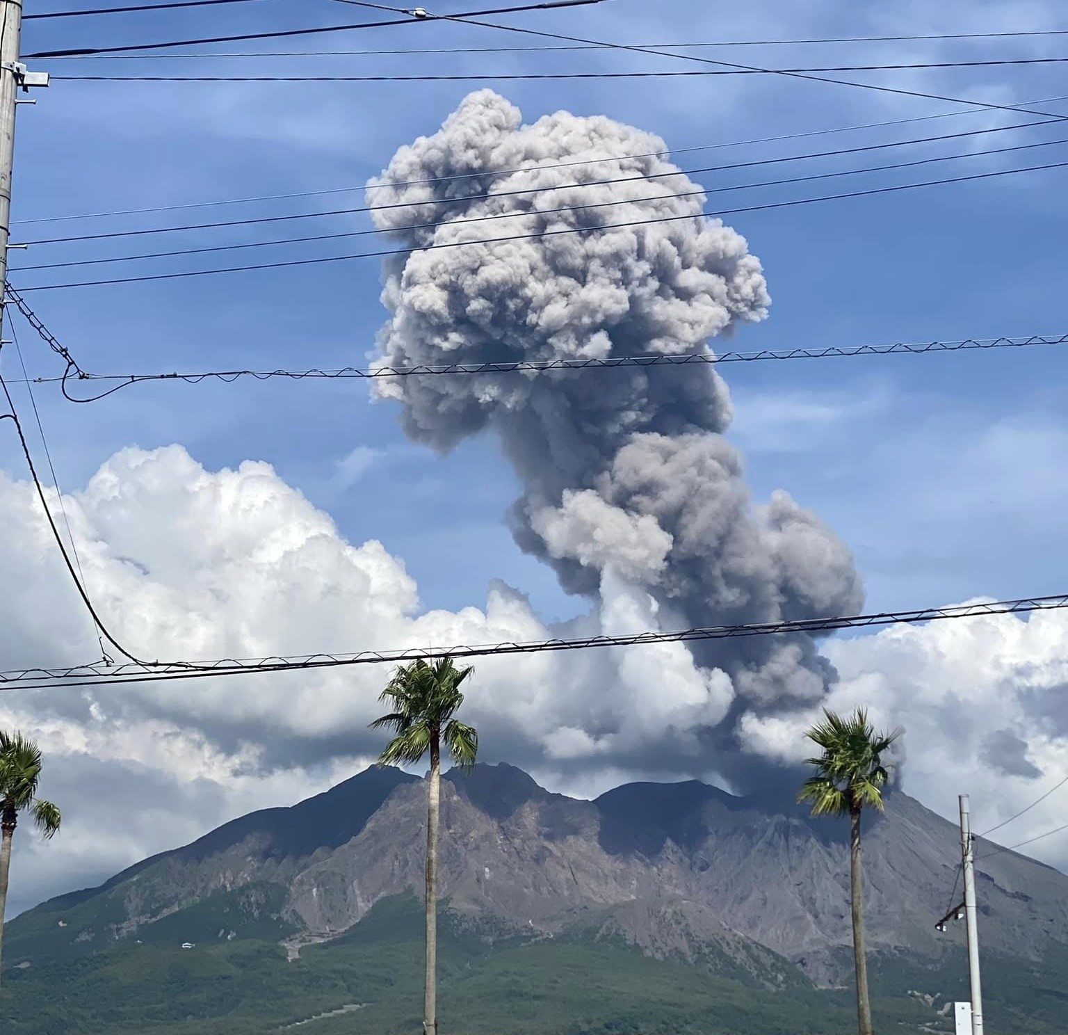
Japan , Sakurajima :
The Japan Meteorological Agency (JMA) reported ongoing eruptive activity at Minamidake Crater (Aira Caldera’s Sakurajima volcano) during 7-14 April. Nightly crater incandescence was visible in webcam images. An explosion at 11h48 on 7 April generated an ash plume that rose 2.9 km above the crater rim and drifted SE. Large blocks were ejected 600-900 m from the vent. An eruptive event at 12h27 on 7 April generated an ash plume that rose 1.3 km above the crater rim and drifted SE. An explosion at 22h20 on 13 April generated an ash plume that rose 1.2 km above the crater rim and drifted E. Large blocks were ejected 500-700 m from the vent. On 7 April sulfur dioxide emissions were slightly higher than average at 1,800 tons per day. The Alert Level remained at 3 (on a 5-level scale), and the public was warned to stay 2 km away from both the Minimadake and Showa craters.
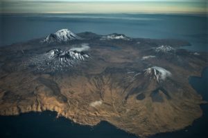
The Aira caldera in the northern half of Kagoshima Bay contains the post-caldera Sakurajima volcano, one of Japan’s most active. Eruption of the voluminous Ito pyroclastic flow accompanied formation of the 17 x 23 km caldera about 22,000 years ago. The smaller Wakamiko caldera was formed during the early Holocene in the NE corner of the caldera, along with several post-caldera cones. The construction of Sakurajima began about 13,000 years ago on the southern rim and built an island that was joined to the Osumi Peninsula during the major explosive and effusive eruption of 1914. Activity at the Kitadake summit cone ended about 4,850 years ago, after which eruptions took place at Minamidake. Frequent eruptions since the 8th century have deposited ash on the city of Kagoshima, located across Kagoshima Bay only 8 km from the summit. The largest recorded eruption took place during 1471-76.
Sources: Japan Meteorological Agency (JMA), GVP.
Photo : Kumiko Nagai
Colombia , Chiles / Cerro Negro :
San Juan de Pasto, April 15, 2025, 4:15 p.m.
Monitoring the activity of the Chiles/Cerro Negro volcanoes, the Colombian Geological Survey (SGC), an entity affiliated with the Ministry of Mines and Energy, reports that:
Between April 8 and 14, 2025, and compared to the previous week, the most notable changes in the volcano’s behavior were:
● A decrease in seismic activity and an increase in the total energy released.
● The predominance of seismicity associated with rock fracturing within the volcanic system continued, followed by the recording of events associated with fluid dynamics (some of them with very low frequency content).
● Localized seismicity showed a concentration similar to that of previous weeks, both at the summit and in the collapse zone of Chiles Volcano, at distances of less than 3 km, with depths between 3 and 5 km from its summit (4,700 m above sea level). Other events were located scattered southeast of Chiles Volcano, at distances of up to 10 km, at depths between 6 and 11 km, and with a maximum magnitude of 2.1. No earthquakes were reported as felt.
● Evaluation of information from satellite sensors and ground stations to detect the deformation of volcanic structures continued to reveal changes associated with deformation processes in the volcanic area. Based on the assessment and correlation of monitored parameters, the SGC recommends closely monitoring their developments through weekly bulletins and other information published through our official channels, as well as instructions from local and departmental authorities and the National Disaster Risk Management Unit (UNGRD).
Volcanic activity remains on Yellow alert: Active volcano with changes in the baseline behavior of monitored parameters and other manifestations.
Source et photo : SGC.