April 15 , 2025.
Philippines , Kanlaon :
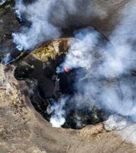
Ongoing ash emission at Kanlaon Volcano which began at 11:52 AM today, 14 April 2025 has been generating voluminous ash plumes as tall as 800m from the summit crater. Ash is currently being drifted west-northwest of the volcano. Residents of La Carlota City, Bago City, and other nearby towns should expect ashfall. Alert Level 3 prevails over Kanlaon Volcano.
Ash emission has ended at 02:12 PM.
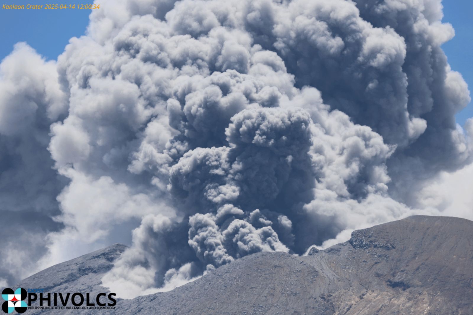
A second ash emission event at Kanlaon Volcano began at 02:53 PM today, 14 April 2025, generating a voluminous ash plume as tall as 600 m from the summit crater. Ash is currently being drifted west-northwest of the volcano. Residents of La Carlota City, Bago City, and other nearby towns should expect ashfall. Alert Level 3 prevails over Kanlaon Volcano.
Source et photo : Phivolcs
Indonesia , Dukono :
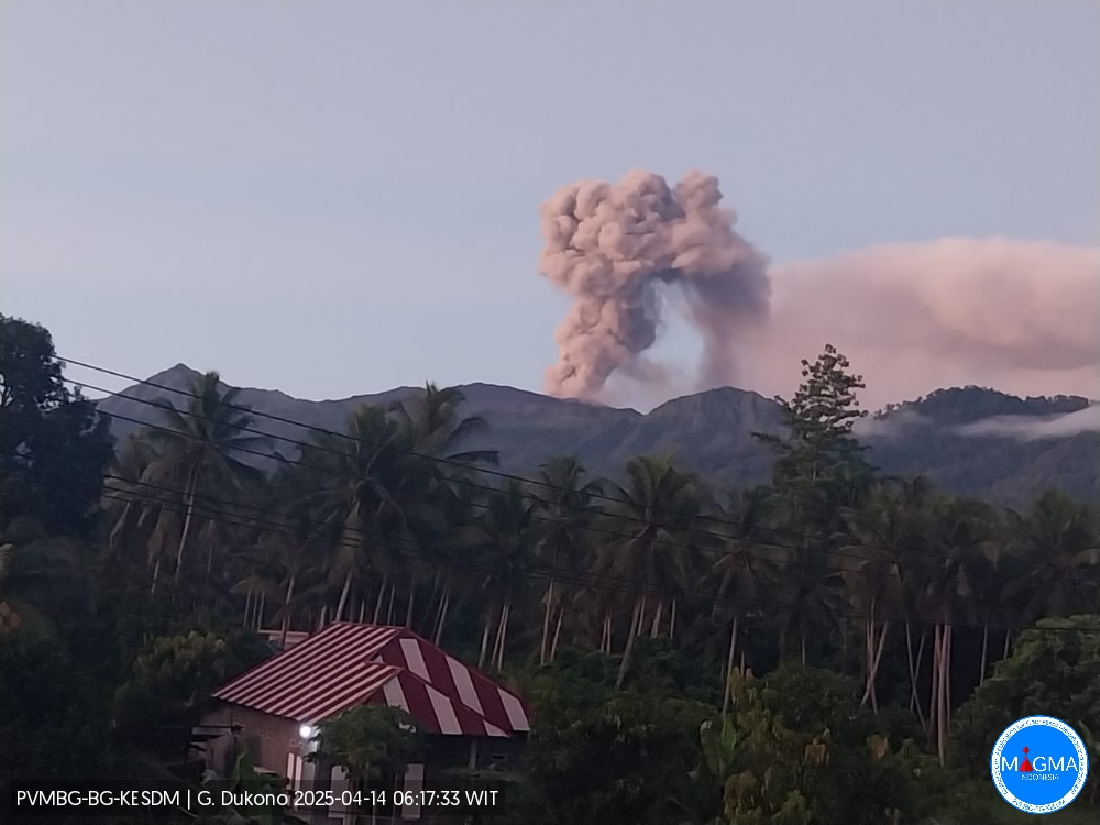
An eruption of Mount Dukono occurred on Monday, April 14, 2025, at 06:05 WIT with an observed ash column height of ± 900 m above the peak (± 1987 m above sea level). The ash column was observed to be white to gray in color with a thick intensity, oriented northwest. At the time of writing, the eruption was still ongoing.
Seismicity Observation:
236 eruptive earthquakes with an amplitude of 6 to 34 mm and a duration of 31.05 to 66.99 seconds.
1 Continuous Tremor earthquake with an amplitude of 2-5 mm, dominant value 3 mm.
Recommendation
(1) People around Mount Dukono and visitors/tourists should not engage in activities, climb, or approach the Malupang Warirang crater within a 4 km radius.
(2) Given that volcanic ash eruptions occur periodically and the distribution of ash follows wind direction and speed, such that the area where the ash lands is not constant, people around Mount Dukono are recommended to always wear masks/nose and mouth coverings to use when needed to avoid the threat of volcanic ash to the respiratory system.
Source et photo : Magma Indonésie .
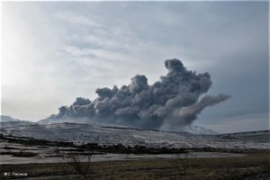
Kamchatka , Bezymianny :
VOLCANO OBSERVATORY NOTICE FOR AVIATION (VONA)
Issued: April 11 , 2025
Volcano: Bezymianny (CAVW #300250)
Current aviation colour code: ORANGE
Previous aviation colour code: orange
Source: KVERT
Notice Number: 2025-17
Volcano Location: N 55 deg 58 min E 160 deg 35 min
Area: Kamchatka, Russia
Summit Elevation: 2882 m (9452.96 ft)
Volcanic Activity Summary:
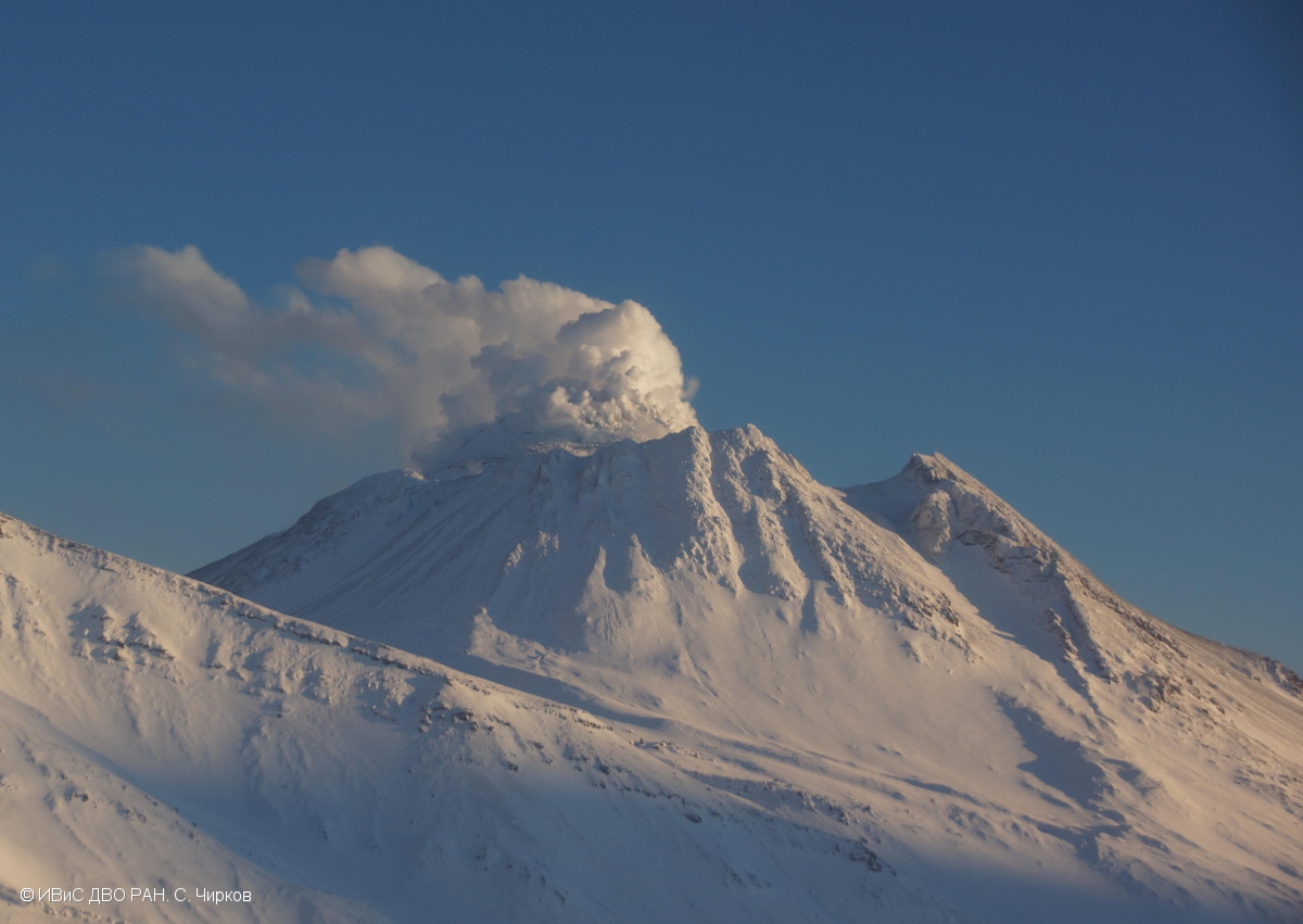
An extrusive-effusive eruption of the volcano increased significantly on 11 April: hot avalanches collapsed on the eastern slopes of the lava dome, and the ash from which rose up to 3-4 km a.s.l. Satellite data by KVERT showed an ash plume extending about 90 km to the north-east of the volcano.
An effusive activity of the Bezymianny volcano is gradually increasing, probably the volcano is preparing for a strong explosive eruption. Ash explosions up to 10-15 km (32,800-49,200 ft) a.s.l. could occur at any time. Ongoing activity could affect international and low-flying aircraft.
Volcanic cloud height:
3000-4000 m (9840-13120 ft) AMSL Time and method of ash plume/cloud height determination: 20250411/1910Z – Himawari-9 14m15
Other volcanic cloud information:
Distance of ash plume/cloud of the volcano: 90 km (56 mi)
Direction of drift of ash plume/cloud of the volcano: NNE / azimuth 16 deg
Time and method of ash plume/cloud determination: 20250411/1910Z – Himawari-9 14m15
Source : Kvert
Photo : S. Chirkov, IVS FEB RAS ( 2023 )
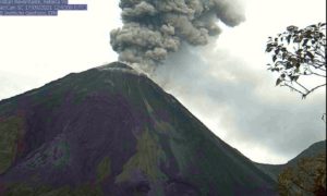
Costa Rica , Poas :
Latitude: 10.2
Longitude: -84.233
Height: 2,687 meters
Observed Activity:
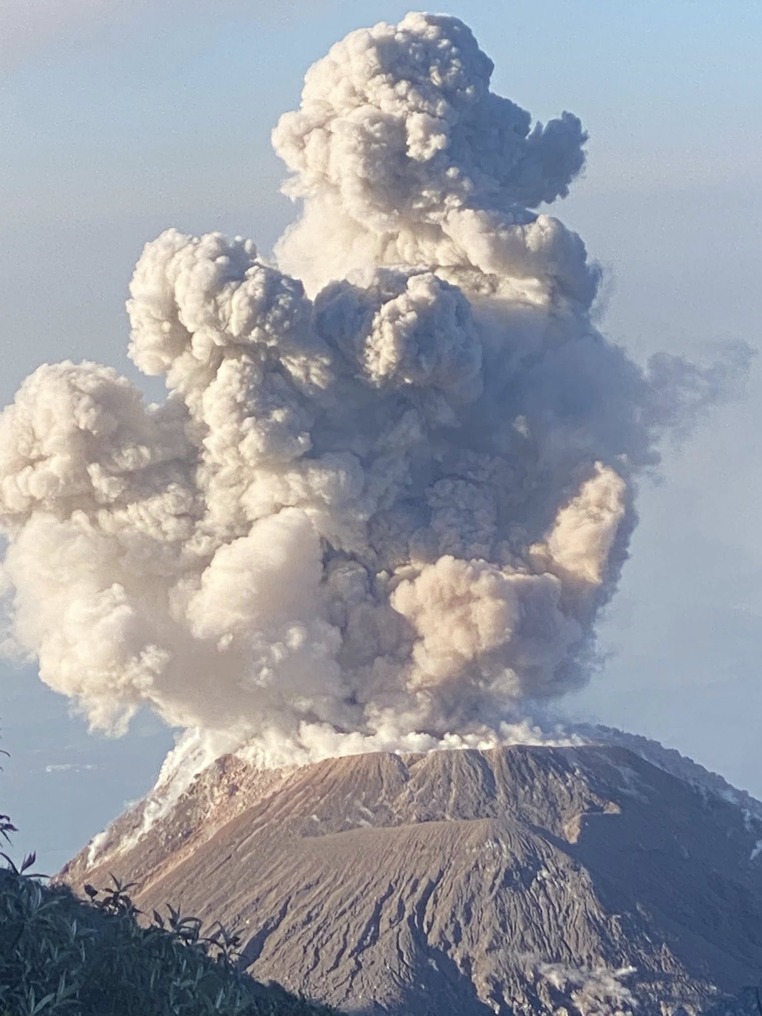
Eruptive activity at Poás is virtually continuous, with plumes rich in gas, water vapor, ash, and rock rising to heights between 100 and 400 meters from the crater floor. Seismographs and infrasound sensors record volcanic tremor signals and numerous acoustic signals in a sustained manner, with frequent variations in signal amplitudes associated with periods of partial blockage of the conduits and periods of partial opening of the conduits.
The SENTINEL satellite detected a mass of SO2 from Poás of 249 tons on April 9, a significantly lower quantity than the amount recorded on April 8 (1,300 tons). The OVSICORI-UNA air quality reference station located in Coronado San José detected SO2 gas from the Poás Volcano between 4 and 19 parts per billion (ppb) between April 7 and 8. Meanwhile, the LAQAT-UNA gas and particle analyzer located on the roof of the Poás Volcano National Park visitor building detected ambient air SO2 concentrations between 3,000 and 6,000 ppb between April 7 and 8, two orders of magnitude higher than the SO2 gas concentrations detected in Coronado. From noon on April 8 to today, the average ambient air SO2 concentration in Coronado is 1.5 ppb.
Environmental Conditions:
The prevailing wind at the summit of Poás is blowing west at 45 km/h at the time of this report (IMN). Residents west of the volcano are reporting illnesses in humans and animals (sore throat, headache, watery eyes, runny nose, allergies). To protect themselves from ash, adults without respiratory problems can wear N95 or FFP2 masks. Animals should be kept indoors or in the house (pets). It is important to protect water and food and feed from ash, as these same chemicals, at certain concentrations, are harmful to people and animals and reduce the quality of water, soil, and air. The ash emitted by Poás is rich in sulfates, chlorides, and fluorides. Excess sulfate and fluoride in water, soil, and food causes digestive health problems in humans and animals (diarrhea), and in the case of fluoride, excess of this chemical causes serious damage to the bones and teeth of animals and humans (skeletal and dental fluorosis).
Activity Level: Caution (3)
Source : Ovsicori.
Photo : Armando Pineda. 13 avril 2025.
Chile , Puyehue / Cordon Caulle :
For the period evaluated, a slight increase was observed in the number of volcano-tectonic (VT) events, associated with rock fracturing within the volcano, compared to the previous period. However, their energy levels remained similar.
The highest-energy VT event recorded had a local magnitude (LM) of 2.1 and was located 1.8 km east-northeast (ENE) and at a depth of 4.3 km from the 2011 emission center.
Activity associated with fluid movement within the volcano (LP) showed similar levels to the previous period in the number of recorded events. The reduced displacement (RD) value of the highest-energy event was 8.1 cm².
The occurrence of a Tornillo-type seismic event (TO) was highlighted, associated with fluid dynamics within the volcanic system; whose energy, measured from its reduced displacement, was 6.9 cm².
Based on information obtained via the GNSS network, it is observed that the uplift process maintained deformation rates similar to those of the previous period, with maximum values of 1.1 cm/month in the vertical component and 0.9 cm/month in the horizontal component.
Low-power thermal anomalies were detected northeast of the 2011 active crater, with a maximum volcanic radiative power (VRP) of 1.4 MW on March 18, according to MIROVA.
Surveillance camera images did not indicate any surface activity associated with the volcanic complex. However, following the onset of moderate to strong winds from the west (the Puelche wind) on March 23, the remobilization and resuspension of ash deposited during the 2011 eruption were recorded. This was reported by the VAAC (Volcanic Ash Advisory Center) in Buenos Aires.
Source : Segemar / OAVV .
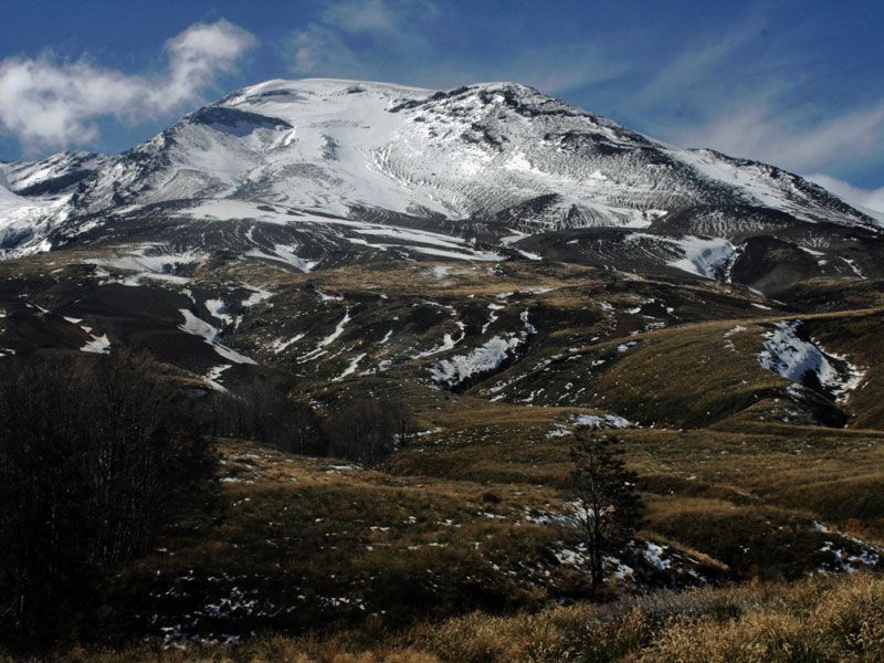
Photo : Huella Andina Expeditions